


North Peak Resources Ltd. (TSX-V: NPR) (OTCQB: NPRLF) announces results from the remaining holes of the 2025 RC drill program at the Dean Cave and Lower PME targets (Areas 3 and 4 in Figure 3) on its 100% owned Prospect Mountain property, Nevada.
The latest results from the Lower PME area have returned a significant, broad intersection around the Hamburg-Dunderberg (Ch/Cd) contact, indicating that the same contact generating the large mineralizing system present to the east of the Property, on the Windfall trend (currently being drilled by McEwen Mining Inc.) continues downdip onto the Property.
Drilling Highlights:
“Finding 90 meters of continuous mineralization in the Lower PME area is a pivotal moment for our exploration thesis,” said Rupert Williams, CEO of North Peak. “While the average grade is modest, the sheer scale of the alteration and the consistency of the gold and silver values are classic hallmarks of being on the doorstep of a much larger system. Given the extensive drilling activity of McEwen Mining at the same contact zone immediately to the east and south of the Property, we think this is a very important result for the Company.”
Area 4: Lower PME – Three holes were drilled into this area totaling 1416m with only PM25-014RC hitting the target contact zone of the Hamburg Dolomite (Ch) and the Dunderberg Shale (Cd). This contact is regionally important for controlling mineralization and is associated with the Windfall trend mineralization and Ruby Deeps resource. The zone is significant in that it was consistently mineralized throughout, and although mostly oxidized, was only weakly bleached. The intersection is typically enriched in Au, Ag, As, Tl, Zn and Pb, and is very similar to historic hole HRH1725 mentioned above, which also encountered mineralized Ch above the Cd contact. The area is structurally complex, and further drilling needs to be undertaken to understand the significance of this new intersection in the context of the historical hole and the other holes which were finished too soon to reach target. Drill targeting is difficult, as the Ch-Cd contact is hidden beneath barren cover rocks. The company intends to seek permission for further pads in this area with the intention of drilling later in 2026.
Area 3: Dean Cave complex – Three holes were drilled to completion in this area totaling 1419m and two holes were abandoned due to excessive deviation and a stuck hammer respectively. The holes were aimed to test for the upward continuation of mineralization from the Dean and East Cave complexes along the projected fault intersections. Despite promising alteration and gossan being present in the upper part of the holes, in the vicinity of the historic Orange tunnel, gold values were only weakly anomalous. A best assay of 1.01 g/t Au over 5ft is recorded in hole PM25-012RC. Long intersections of anomalous zinc are associated with the alteration and gossans suggesting the holes were slightly distal to main mineralization.
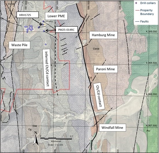
Figure 1: Lower PME area in relation to the Windfall trend currently being drilled by McEwen mining.
The Company also continues to progress assessing the waste pile economic viability and metallurgical tests are ongoing, with results now expected in Q2 2026. These results will enable the Company to assess and formalize toll processing options.
| Hole ID | from (m) | to (m) | interval (m) | interval (ft) | Au g/t | Ag g/t | Pb % | Zn % |
| PM25-012RC* | 25.91 | 27.43 | 1.52 | 5 | 1.01 | 161 | 0.74 | 0.56 |
| PM25-014RC * | 30.1.75 | 303.28 | 1.53 | 5 | 1.1 | 13.6 | 0.51 | 0.36 |
| PM25-014RC | 425.20 | 513.59 | 88.39 | 294 | 0.24 | 15.7 | 0.55 | 1.68 |
Table 1: Significant assay intervals, reported with a 0.1 g/t Au cutoff and 10m internal dilution. True widths are unknown but expected to be >70% of the intervals. Intersections marked with * are with a 0.5 g/t Au cutoff.
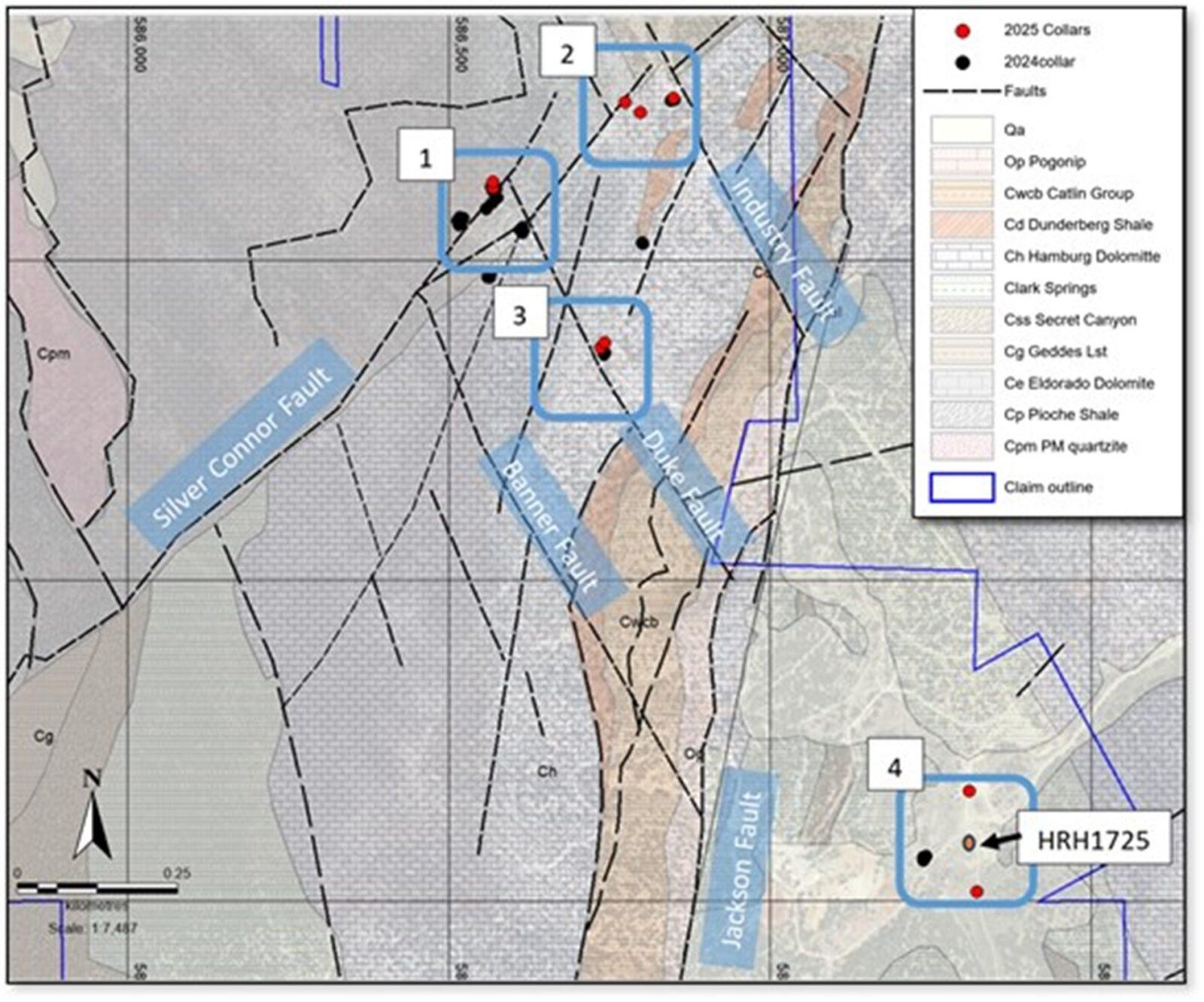
Figure 2. Geology map showing drill areas for 2025 campaign (numbered light blue boxes), and their geologic context. 1) Wabash/Williams, 2) Industry Tunnel, 3) Dean Cave, 4) Lower Prospect Mountain East (Lower PME).
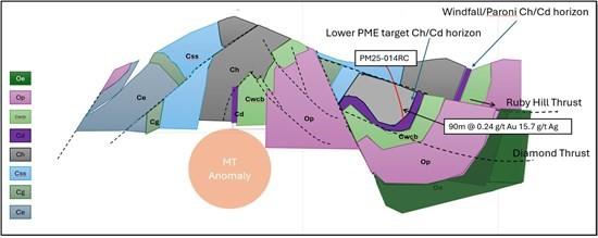
Figure 3. Section showing one possible interpretation of the critical ChCd horizon and mineralization on PM Property.
| Hole | Total Depth (m) |
Total Depth (ft) |
Easting | Northing | Elev_m | Azimuth | Dip | Area | Comment |
| PM25-007RC | 260.6 | 855 | 164879 | 8524283 | 2592 | 222 | -57 | 3 | Abandoned |
| PM25-008RC | 492.3 | 1615 | 164880.7 | 8524284 | 2598 | 222 | -50 | 3 | |
| PM25-009RC | 510.5 | 1675 | 164880 | 8524282 | 2597 | 215 | -43 | 3 | |
| PM25-010RC | 327.7 | 1075 | 165442.4 | 8523591 | 2343 | 92 | -60 | 4 | |
| PM25-011RC | 510.5 | 1675 | 165439.9 | 8523587 | 2337 | 125 | -60 | 4 | |
| PM25-012RC | 291.1 | 955 | 164879.9 | 8524285 | 2585 | 205 | -44 | 3 | Abandoned |
| PM25-013RC | 416.1 | 1365 | 164882.1 | 8524284 | 2596 | 206 | -44 | 3 | |
| PM25-014RC | 577.6 | 1895 | 165450.2 | 8523433 | 2348 | 114 | -58 | 4 |
Table 2: Drill hole coordinates and data.
Review by Qualified Person, Quality Control and Reports
Mr. David Pym, CGeol., independent Consulting Geologist for the Company, is the Qualified Person, as defined under National Instrument 43-101 – Standards of Disclosure for Mineral Projects, who reviewed and approved scientific and technical disclosure in this press release. The Qualified Person has not reviewed the mineral tenure, nor independently verified the legal status and ownership of the Property or any underlying property agreements.
Drilling and Sampling: Drilling was carried out using a Canadian built tracked MultiPower Explorer RC drilling unit, the rig has jacks and a blade and is capable of working on small pads on steep ground to minimise ground prep. It is capable of drilling to 609m (2000ft) using 4-inch pipe and a 5 1/4-inch bit. Holes were cased down to 5-30ft with 8-inch steel casing drifted in using a tricone bit. RC drilling uses a hammer, that is not face sampling but samples 4ft away from the hammer. A face sampling hammer was also used in areas of expected grade. Under Nevada law, dry sampling is not allowed due to dust restrictions, so RC drilling is done wet, with water actively pumped down the hole mixing with pulverised sample and coming through the cyclone to an 8-compartment rotary fan wet splitter. Each compartment can be shut off giving control of the amount of split material. Rotary splitter was set up with 1:8 split, with the eighth split going into two calico bags housed in buckets, for an assay sample and a field duplicate for permanent reference. The remainder of the sample falls to the ground and runs into the sump. Each assay sample is for a 5ft (1.52m) interval. The splitter and cyclone are flushed every 4 samples or on noticing a change in colour. Chips were collected from the splitter reject and put into chip trays for reference. Calico bags are pre-labelled with hole number and footage, with an FD for field duplicate added to the sample number for the field duplicate. The drilling team are responsible for changing the bags and the clearly labelled footage intervals on the bags avoids sample mix-ups. Filled sample bags are laid on the ground in order so a visual check can be easily performed when collecting samples. Samples are loaded into a plastic crate and dispatched daily to the ALS Global prep-lab in Elko, Nevada. A standard, a blank and a field duplicate were inserted after every 20 samples, for a QA/QC rate of 15%. Six standards from CDN Resource Laboratories were rotated through the samples. The standards had gold values ranging from 0.433 to 7.34 ppm. Samples are dried crushed and pulverised and assayed for gold with a 30g fire assay and a 44 element ICP MS suite. Overlimit samples for gold, silver, lead, zinc and copper are automatically re-assayed by suitable methods.
About North Peak
The Company is a Canadian based gold exploration and development company listed on the TSX Venture Exchange under the symbol “NPR” and the OTCQB under the symbol “NPRLF”. Launched by the founding team behind both Kirkland Lake Gold and Rupert Resources, the team has a strong track record of acquiring mining assets, applying modern exploration techniques and taking them into operational mines.
North Peak’s flagship property is the Prospect Mountain Mine complex which lies in the Battle Mountain Eureka trend, in an area known as the Southern Eureka Gold Belt, where three styles of mineralization have been identified, gold, silver Carlin style mineralization, Carbonate Replacement gold, silver, lead, zinc mineralization (CRD) and carbonate hosted Porphyry Related Skarn lead, zinc and gold mineralization associated with cretaceous intrusions. At the Property, the CRD mineralization is heavily oxidized to depths of at least 610m (2,000ft) below the top of the ridge line.
A Plan of Operations is in place which covers part of the Property and entitles an operator to pursue surface exploration (totaling 189 acres), underground mining of up to 365,000 tons per annum and certain infrastructural works. A more complete description of the Property’s geology and mineralization, including at the Wabash area, can be found in the NI 43-101 Technical Report on the Prospect Mountain Property, Eureka County, Nevada, USA dated and with an effective date April 10, 2023, prepared by David Pym (Msc), CGeol. of LTI Advisory Ltd. and Dr Toby Strauss, CGeol, EurGeol., of Merlyn Consulting Ltd., which has been filed on SEDAR+ at www.sedarplus.ca under the profile of the Company and on the Company’s website.
First Phosphate Corp. (CSE: PHOS) (OTCQX: FRSPF) (OTCQX ADR: FPH... READ MORE
Highlights: Hole NO-26-21a returned 11.37 m grading 4.92 g/t gold... READ MORE
Guanajuato Silver Company Ltd. (TSX-V:GSVR) (OTCQX:GSVRF) is pl... READ MORE
Falco Resources Ltd. (TSX-V:FPC) is pleased to announce the resul... READ MORE
TDG Gold Corp. (TSX-V: TDG) (OTCQX: TDGGF) is pleased to provide ... READ MORE


