Uncategorized
XIMEN’S QUARTZ MOUNTAIN PROJECT: 2022 Soil and Rock Geochemical Highlights

Ximen Mining Corp. (TSX-V: XIM) (FRA: 1XMA) (OTCQB: XXMMF) announces results from rock and soil geochemical surveys conducted on the Quartz Mountain property in 2022. Rock sampling of the Anderson’s Pit area yielded 12.2 g/t Au, 62.2 g/t Ag, and 2.9 wt.% Pb on a channel sample of 1.2 m.
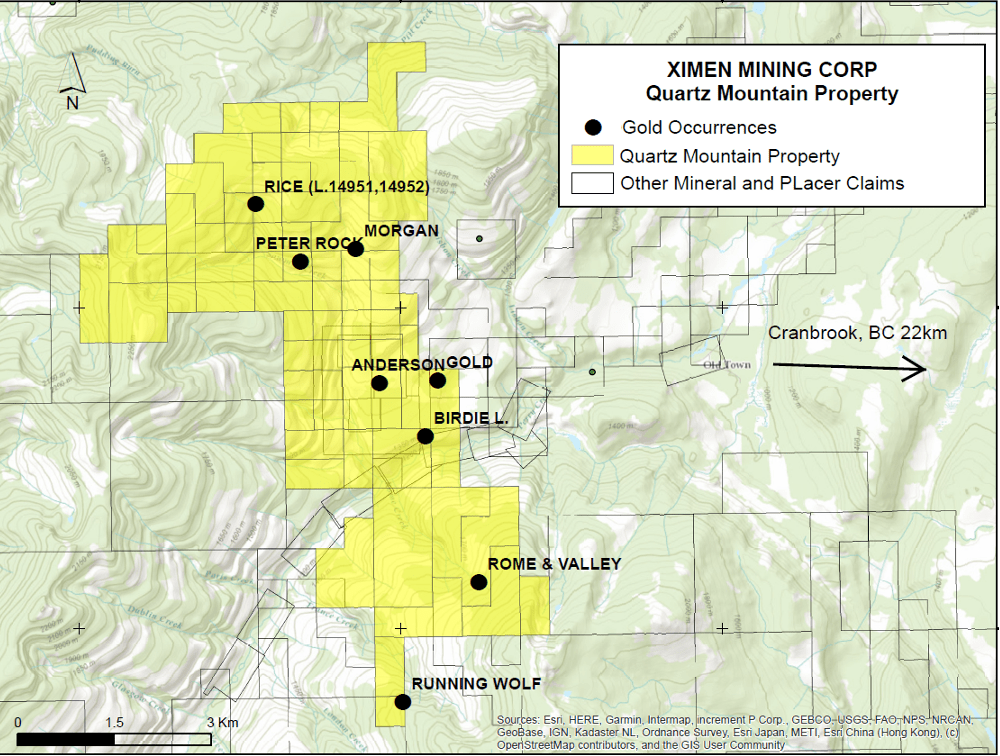
Ximen’s Quartz Mountain property is located 12.5 km southwest of Kimberly, B.C. and 22 km west of Cranbrook, BC. The property consists of two blocks of claims covering 3,829 hectares and 13 mineral occurrences. The northern block was explored in 2022 and covers 8 mineral occurrences with past production and known showings of gold. Field work in 2022 consisted of GPS surveying of historic workings, verification sampling of known gold occurrences, soil geochemistry, and drone photogrammetry.
The Quartz Mountain property straddles Perry Creek, on which there are modern and historic placer gold workings. Perry Creek lies near the center of the 100 km long and 30 km wide Kimberley Gold Trend, which covers placer gold deposits on the Wild Horse River, Perry Creek and the Moyie River. Originally discovered in 1864, available information suggests at least 1.5 million ounces of gold have been recovered and small placer operations continue on each of these water courses today, 150 years after discovery. A significant lode gold source for the rich placer deposits has not been discovered, although many occurrences have been located (Geoscience BC Report 2015-1). The Kimberley Gold trend is centered around the St. Mary’s and Moyie faults and overlies the Vulcan basement tectonic zone which influenced structural development and helped focus fluid flow during Jurassic and Cretaceous folding, faulting and intrusion (Thompson, 2010).
Map showing soil geochemical survey and rock sample results from Anderson’s pit area
On the Quartz Mountain property, Anderson’s pit was mined historically (381 tonnes, 102 ounces gold, 167 ounces silver and 200 kg lead according to BC Minfile records). It consists of a quartz vein with a true thickness of about 2.5 m that is oriented 175/40°W. Rock chip sampling in 2022 yielded 12.2 g/t Au, 62.2 g/t Ag, and 2.9 wt.% Pb on a channel sample of 1.2 m. A soil geochemical survey conducted northeast from Anderson’s pit showed a gold anomaly extending along the projection of the vein (see map). Analytical results ranged from the detection limit of 0.001 to 0.167 ppm gold. The results are also encouraging because the orientation of the vein and trend of the soil anomaly coincides with the orientation of the Perry Creek fault, suggesting this fault is a fundamental control on the location of the gold mineralization. A subparallel gold anomaly is seen further east, and an isolated anomaly occurs on the easternmost extent the soil grid that coincides with another occurrence named “Gold”. The local geological structure is an antiform within the Creston Formation, and the interpreted hinge area coincides with the Perry Creek fault, close to the Anderson’s pit. This fold structure may be another control on the localization of gold.
Plans for 2023 are to extend the soil geochemical grid to the east. Geochemical surveys will also be done at other occurrences on the property.
Soil geochemical analyses reported herein consisted of aqua regia digestion and ICPMS (Inductively coupled plasma – Mass Spectroscopy) determination on a 50-gram sample. This multielement package provides results for 51 elements including gold and silver. Quality control blank and certified reference samples were inserted into the sample stream at a frequency of 1 in 20 for each type, or one control sample every 10 samples. Rock geochemical analyses reported herein were by fire assay of a 50 gram sample and determination by atomic absorption spectrometry.
Readers are cautioned that historical records referred to in this News Release have been examined but not verified by a Qualified Person. Further work is required to verify that historical records referred to in this News Release are accurate.
Dr. Mathew Ball, P.Geo., VP Exploration for Ximen Mining Corp. and a Qualified Person as defined by NI 43-101, approved the technical information contained in this News Release.
Posted May 11, 2023
MORE or "UNCATEGORIZED"
Red Pine Provides Further Update On Assay Results for Wawa Gold Project
Red Pine Exploration Inc. (TSX-V: RPX) (OTCQB: RDEXF) further to... READ MORE
May 10, 2024
Getty Copper Intersects High-grade Copper Mineralization in the First Drill Holes, Glossie Occurrence, Highland Valley Area, Southern B.C.
Getty Copper Inc. is pleased to report drill results from the fir... READ MORE
May 10, 2024
Guanajuato Silver Announces Closing of C$11.35 Million Brokered Financing
Guanajuato Silver Company Ltd. (TSX-V:GSVR) is pleased to announc... READ MORE
May 10, 2024
Hot Chili Closes A$24.9 Million Private Placement and Announces Full Underwriting of A$5 Million Share Purchase Plan
Positioning for Near-Term, Meaningful, Copper Production H... READ MORE
May 10, 2024
Barksdale Announces San Javier Preliminary Economic Assessment
Barksdale Resources Corp. (TSX-V: BRO) (OTCQX: BRKCF) is pleased ... READ MORE
May 9, 2024


