








West Point Gold Corp. (TSX-V: WPG) (OTCQX: WPGCF) (FSE: LRA0) is pleased to announce the drilling of additional shallow gold mineralization at the Black Dyke prospect located 4 kilometres west of the Tyro Main Zone at its Gold Chain Project in Arizona (Figure 1). The results are highlighted by GC26-144, which intersected 7.6 metres of 2.22 grams per tonne gold, and GC26-146, which intersected 16.8m of 0.90 g/t Au, both within less than 75m from surface. All holes intersected mineralization. Mineralization in the area suggests the potential to add future resource ounces to the project and warrants additional test work and drilling.
The initial program (PR link) consisted of six RC holes for a total of 626.4 metres, with follow-up drilling consisting of five holes totalling 603.4m. These holes were part of the recently completed 21,079m 2025-2026 drilling campaign at its flagship Gold Chain Project in Arizona. The Company recently acquired a significant amount of historical data for the Black Dyke target, which includes high-grade drill results completed by prior operators. West Point Gold’s drilling to date, along with the recently acquired historic data, is expected to improve targeting at the Black Dyke target when drilling resumes.
Highlights:
“Our drill results from 2026, combined with the recently acquired historical drill data, provide West Point Gold with a clearer view of the potential at Black Dyke. Our drilling, along with the recently acquired historical data, suggests that this target warrants further drilling. The Company continues to believe that additional drilling at the target area may result in a satellite resource at the Gold Chain project,” stated Derek Macpherson, President and CEO.
Table 1: Drill Results
| Holes | From (m) | To (m) | Width (m) | Grade (g/t Au) |
| GC26-143 | 54.9 | 61.0 | 6.1 | 1.49 |
| GC26-144 | 62.5 | 70.1 | 7.6 | 2.22 |
| GC26-146 | 71.6 | 88.4 | 16.8 | 0.90 |
| GC26-149 | No Significant Intercepts | |||
| GC26-150 | No Significant Intercepts | |||
Note: All widths shown are downhole; true widths are greater than 80% of downhole widths.
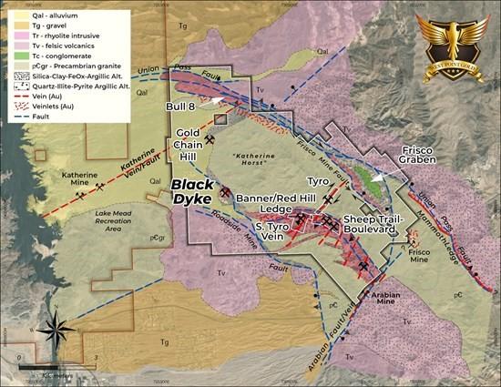
Figure 1. Simplified geologic map of the Gold Chain Project and surrounding area showing the location of the Black Dyke prospect.
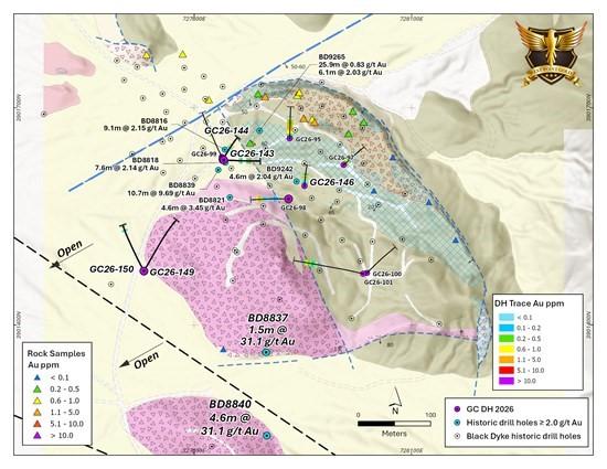
Figure 2. Geologic map of the Black Dyke prospect showing drill holes and surface samples. The holes reported within are highlighted along with historical holes exceeding 2 g/t Au.
Black Dyke Exploration Update
The Black Dyke Mine is located 4.8km east of the Katherine Mine and 4.0km west of the Tyro Mine (Figure 1). The mine’s history and geologic setting were previously summarized (PR link). Recent drilling, shown in Figure 2 and Table 1, reflects a shallow, southwest-dipping structure referred to as the Black Dyke, which is hosted by the Precambrian granite. The mineralized zone has been described as a “vein breccia, up to 30 metres wide, composed of broken chalcedony vein and breccia cemented by a massive to banded, coarsely crystalline gray calcite with elevated manganese”. It is noteworthy that the Katherine Mine was productive in similar quartz-calcite-adularia veins, veinlets and breccia to a depth up to 300m below the current surface. This depth, along with the steam-generated alteration in the volcanic rocks above the Black Dyke zone, supports West Point Gold’s belief that current exploration at Black Dyke is within the uppermost levels of a deeper gold system.
West Point Gold has recently purchased a data package including results from several historical drilling campaigns across the Black Dyke prospect (Figure 3). The data contains 74 holes drilled by Western States Mining Company (“Western States”) from 1986 to 1992, including geochemical data, collar locations and geological cross-sections. The data also includes reference to 57 holes drilled by American Copper and Nickel Company (“ACNC”) but only includes collar locations. All holes drilled by Western States and ACNC were reverse-circulation holes. A total of 32 of the ACNC holes were drilled to aid geologic mapping by measuring alluvial cover and noting bedrock geology; the holes did not exceed 30.5m in depth. The purchased data is proving useful to West Point Gold for targeting purposes but is considered NI43-101 non-compliant.
Figure 3 provides a view of the recently acquired data in and around the Black Dyke prospect. A few observations emerge from this data:
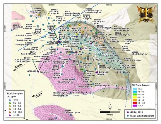
Figure 3. Geologic map of the Black Dyke prospect and surrounding area showing West Point Gold’s 2026 drill holes along with non-compliant historical holes drilled in 1986 – 1992 and 2009. Hole number and reported gold grades are shown.
Current exploration at the Northeast Tyro zone is revealing that a strong vein and breccia body can grade into weakly mineralized and altered Precambrian granite over a short distance (i.e. <10m) and be essentially ‘blind’ to surface exploration. Upper levels at Tyro Northeast reveal weak argillic (illite) and moderate to strong propylitic alteration. In surface exposures, iron oxide replacement of the chlorite may be the only visual guide to mineralization.
The Black Dyke prospect sits along the western flank of the Katherine Horst, and structures here are likely part of the Roadside Mine fault zone, along the Banner-Sheep Trail trend. The surface expression may be subtle, hosting only tectonized Precambrian granite and propylitic alteration (iron oxides at surface). The widespread distribution of thick alluvium accumulations with local hills composed on altered volcanic rocks (inselbergs) makes definition of the Roadside Mine fault difficult.
Geophysical studies (Figures 4 and 5) conducted by West Point Gold are employed to potentially identify controlling structures such as the Roadside Mine fault. As noted above, exploration results at Black Dyke suggest a distal position in the epithermal system. This observation, along with two historical drill intercepts (> 30 g/t Au) beneath strongly altered volcanic rocks, supports a potential concealed ‘feeder’ structure as part of the Roadside Mine fault system. Inspection of both the gravity (Figure 4) and magnetic (Figure 5) data suggests a northwest-trending structure, perhaps a splay of the Roadside Mine fault (normal), to be connected to the Black Dyke gold mineralization.
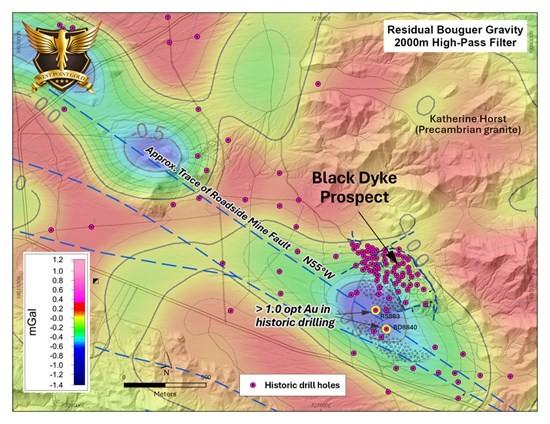
Figure 4. Residual gravity map over the Black Dyke prospect and surrounding area. Gravity lows (blue) are believed to reflect a structural break along the Roadside Mine fault, and the southwest margin of the Katherine Horst) and spatially coincide with altered volcanic rocks in the hanging wall of the fault.
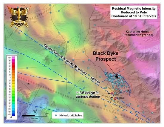
Figure 5. Residual magnetic intensity (RMI) map over the Black Dyke prospect and surrounding area. The magnetic lows (cooler colours) are believed to reflect felsic volcanic and/or intrusive rocks or hydrothermally altered rocks along the margin of the Katherine Horst. A probable splay of the Roadside Mine fault is shown as a blue line.
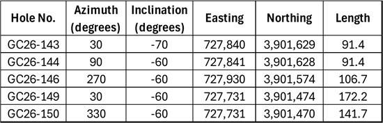
Table 2: Drill hole locations and descriptions
Qualified Person
Robert Johansing, M.Sc. Econ. Geol., P. Geo., the Company’s Vice President, Exploration, is a qualified person as defined by NI 43-101 and has reviewed and approved the technical content of this press release. Mr. Johansing has also been responsible for overseeing all phases of the drilling program, including logging, labelling, bagging and transport from the project to American Assay Laboratories of Sparks, Nevada. Drillholes have a diameter of about 10cm, and samples have an approximate weight of 5 to 10kg. Samples were then dried, crushed and split, and pulp samples were prepared for analysis. Gold was determined by fire assay with an ICP finish, and over-limit samples were determined by fire assay and gravimetric finish. Silver plus 15 other elements were determined by Aqua Regia ICP-AES (IM-2A16), and over-limit samples were determined by fire assay and gravimetric finish. Both certified standards and blanks were inserted on site along with duplicates, standards and blanks inserted by American Assay. The results summarized above have been carefully reviewed with reference to the QA/QC results. Standard sample chain of custody procedures were employed during drilling and sampling campaigns until delivery to the analytical facility.
The QP has not completed sufficient work to verify the historical information received on the Black Dyke target, particularly with regard to historical drill results. However, the QP believes that prior drilling and analytical results were completed to industry standard practices at the time they were drilled.
About West Point Gold Corp.
West Point Gold is an exploration and development company focused on unlocking value across four strategically located projects along the prolific Walker Lane Trend in Nevada and Arizona, USA, providing shareholders with exposure to multiple discovery opportunities across one of North America’s most productive gold regions. The Company’s near-term priority is advancing its flagship Gold Chain Project in Arizona.
Brutus Mining Inc. (CSE: BRU) (FSE: ZI3) is pleased to announce that it has closed its non-brokered ... READ MORE
Jaguar Uranium Corp. (NYSE American: JAGU) is pleased to announce an independent Mineral Resource E... READ MORE
Auro Metals Inc. (TSX-V: AURO) (OTCQB: AURFF), is pleased to announce the assay results of the fina... READ MORE
Endeavour Silver Corp. (NYSE: EXK) (TSX: EDR) is pleased to announce that repairs to the primary bal... READ MORE
Scorpio Gold Corp. (NASDAQ: SGLD) (TSX-V: SGLD) (OTCQB: SRCRF) (FSE: RY9) is pleased to announce re... READ MORE


