


Viscount Mining Corp. (TSX-V: VML) (OTCQB: VLMGF) is pleased to announce it has received additional drill results which have confirmed the recent geophysical and geochemical study at its Silver Cliff property in Colorado.
Viscount is currently wrapping up phase 2, and beginning planning for phase 3 of the multi-phase exploration program. This was an experimental phase, and has made us better understand trends that exists in the Kate Resource area. It has helped us define the relationships between geophysical, geochemical expressions and subsurface data. This exercise was successful, and additional surface soil samples have been collected, and analysis are pending. Several of the drill holes were designed to test the outer limits of the Kate area, and will guide the phase 3 program, that will be designed to expand the Kate Resource area. An additional three holes were drilled in the Passiflora target, and are currently being analyzed to better understand trends and future exploration targets.
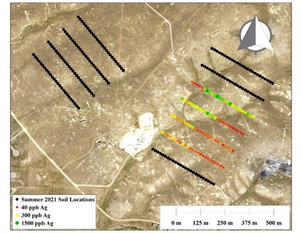
Q2 Soil Locations
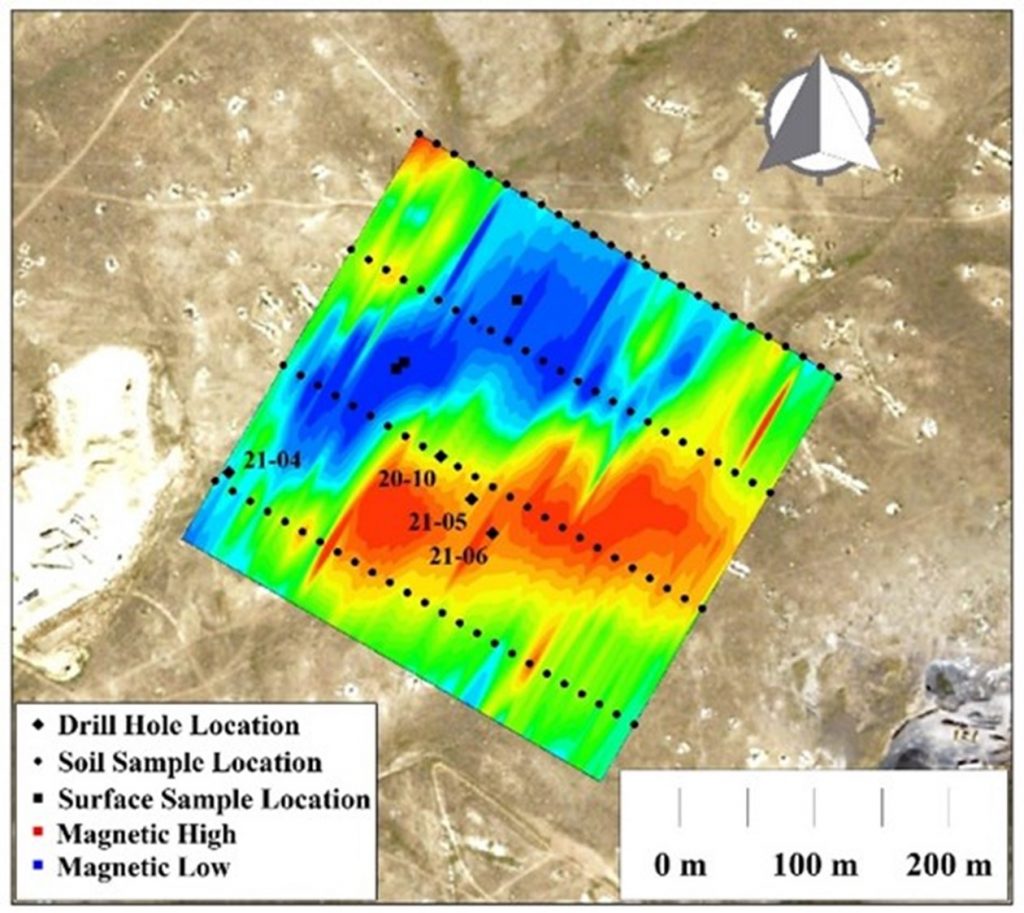
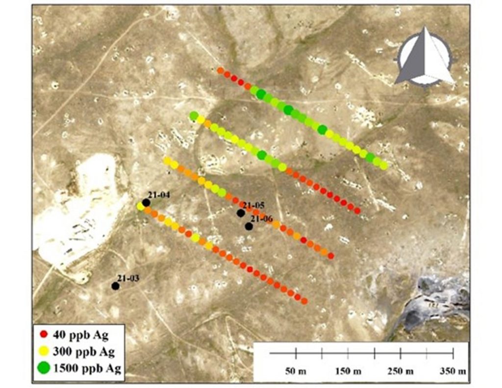
In early March, Viscount Mining conducted an initial soil sampling survey over the Kate East deposit. The results from this 100-sample survey showed the surficial variance of silver concentration, indicating areas of probable silver deposition closer to the surface. In response to these promising results, Viscount Mining decided to conduct a second round of soil sampling. As shown in the image above, this second round of soil sampling includes 175 additional samples. 75 of these account for expanding the area of the initial survey, with one line added to the south, and two lines combined to the higher-concentrated northern area. The last 100 samples of this second soil survey are being collected to the northwest of the current known extent of the Kate deposit. Historic drilling around this area shows some silver deposition near the surface, but no recent data has been collected in this region. Results from this second round of soil sampling will aid in guiding future drilling campaigns and could be key in determining the further extent of the Kate deposit. Analytical results from all five holes drilled in the Kate East zone in Spring 2021 have been received. DDH-21-03, 04, 05, 06 locations are shown on the two maps below, and the holes relation to the soil samples and geomagnetic signature. Hole DDH-21-03 is located outside of the survey areas, but showed 24.4 meters of 51.4 g/t from 14 meters to 34.4 meters, including 128.9g/t silver over 4.4 meters from 27.1 meters to 31.5 meters.
Soil/ Magnetometer Locations
Soil: Silver (ppb)
The first graphic above illustrates higher concentrations of silver seem to appear at the surface above areas of lower magnetism. The concentration of silver in the soil correlates positively with zinc and lead, which is very similar to what we found in the analysis of the core from the 2020 drill program.
From the graphic on the above they both demonstrate that Drill hole DDH-21-04 is located towards the South-West of the survey area in a low magnetic region. It had a medium strong soil sample associated with it. It had two mineralized intervals, one from 0 to 7.6 meters assayed 75.1 g/t silver, and the second from 15.2 meters to 23.5 meters assayed 69.5 g/t silver. The results for DDH-21 – 05 and 06 showed no significant silver concentrations, though both holes showed silver throughout its entire length, with some individual assays of good grade. Holes DDH -2021-05 and 06 were stepped out 50 and 70 meters respectively from the NI 43-101 defined resource. These holes were found to be in a lower grade zone, as was later confirmed by the soil and magnetometer surveys. Hole DDH–2021-06 had a 1.5 meter sample that started at 19.8 meters and assayed 68.4 g/t silver and another 1.5 meter sample that started at 22.9 meters and assayed 61.9 g/t silver respectively. These assays are above the cutoff level for resource calculation according Viscount’s NI 43-101 dated April 15, 2018 that was prepared by Dr. Gilles Arseneau, Ph.D., P. Geo. They do contribute to our understanding of the relationships that exist in the zone.
Both of these holes are in the magnetic high region, and soil geochemical low area. This is a relationship that was anticipated. The magnetic minerals that was present when the hydrothermal fluids altered the rhyolite were destroyed and replaced by the silver bearing fluids.
Phase 2 was designed as an exploration program to test unknown areas and confirm our understanding of the magnetic and soil geochemical areas. Our QP targets in this current program provided him with the ore body direction of mineralization and understanding of additional areas of mineralization. In Phase 3 based on the successful results, Viscount will add further exploration holes to expand the current deposit beyond the historical deposit area.
Holes DDH-21-05 to 07 were used to test limits to the deposit. These holes were of considerable distance from the defined resource established in Viscount’s NI 43-101. Hole DDH-21-07 was located 495 meters from Viscount’s NI 43-101 defined silver resource and was going to twin WH_255_CONO that had a shallow 4.57 meter intercept of 132.39 g/t silver. High voltage powerlines have been installed over the historic hole. This necessitated Viscount to have to move the hole 150 feet away from the power line (MSHA regulations). This was an untested area and the hole still showed anomalous silver mineralization throughout its 125 meter length. Further exploration in this area will be proceeded by soil Geochem or geophysics or both.
KATE EAST ZONE
SUMMARY OF VISCOUNT DRILLED HOLES
| HOLE ID | FROM | TO (M) | LENGTH | AG | INCLUDING | |
| (M) | (M) | G/T | ||||
| K16-1 | 15.8 | 32 | 16.2 | 837.4 | 6.1 M @ 1778.5 G/T | |
| K16-3 | 17.3 | 34.1 | 16.8 | 141.5 | ||
| K16-4 | 15.6 | 36.9 | 21.3 | 179.1 | 13.7 M @ 250.7 G/T | |
| K16-5 | 19.8 | 33.5 | 13.7 | 388.6 | 6.1 M @ 757.3 G/T | |
| K16-6 | 29 | 36.6 | 7.6 | 47.3 | ||
| K16-7 | 23.5 | 38.7 | 15.2 | 153.2 | 7.6 M @ 252.6 G/T | |
| K16-8 | 32.2 | 52.9 | 20.7 | 228.8 | 6.1 M @ 542.3 | |
| K16-9 | 25.9 | 41.1 | 15.2 | 136.6 | ||
| P17-03 | 15.1 | 30 | 15.1 | 702.7 | 9 M @ 477 G/T | |
| P17-05 | 9.5 | 24.5 | 15 | 219.4 | ||
| P17-06 | 0 | 24.5 | 24.5 | 129.3 | ||
| P17-07 | 0 | 25.5 | 25.5 | 50.8 | ||
| DDH20-01 | 19.5 | 41.1 | 21.6 | 100.6 | ||
| DDH20-02 | 15.5 | 25.6 | 10.1 | 63.9 | 7.6 M @ 1259.1 G/T | |
| DDH20-03 | 15.1 | 30 | 14.9 | 702.7 | ||
| DDH20-04 | 15.6 | 30.8 | 15.2 | 105.1 | ||
| DDH20-10 | 0 | 19.5 | 19.5 | 51.9 | 10 M @ 236 G/T | |
| DDH21-01 | 11 | 29.6 | 18.6 | 147.6 | ||
| DDH21-02 | 24.4 | 36.6 | 12.2 | 27.6 | ||
| DDH21-03 | 14 | 38.4 | 24.4 | 51.4 | ||
| DDH21-04 | 0 | 7.6 | 7.6 | 75.1 | ||
| DDH21-04 | 15.2 | 23.5 | 8.2 | 69.4 | ||
| DDH21-05 | 12.2 | 13.7 | 1.5 | 22.6 | ||
| DDH21-06 | 19.8 | 29 | 9.1 | 33.2 | ||
| DDH21-07 | 0 | 30 | 30 | 7.6 |
Jacob Hooker, Exploration Manager at Silver Cliff, “We are improving our understanding and proving out the Kate Silver Deposit. The recent results have reinforced to us that the Kate East Zone has proved to be open in all directions which will make our goal of expanding the current NI 43-101 resource possible. Our Phase 3 exploration program including the next phase of drilling set to begin this summer under the direction of our QP will strategically focus the next set of holes for resource expansion.”
Tenneco Minerals leased the Kate property in 1987. They had previous drill data available to them, which was the results from 11,930 meters in 249 drill holes that had been done since 1968.
The following two years Tenneco drilled an additional 143 holes totaling 7,949 meters. Based on the accumulated data and feasibility study, Tenneco Minerals made the decision to construct a $35,000,000 milling operation for the extraction of the silver reserves at Silver Cliff. Shortly thereafter Tenneco’s parent company was sold, and the planned milling operation was abandoned.
Upon competition and receipt of the current geophysical and geochemical study, Viscount will complete our selection of the Phase 3 drill locations. The number of drill holes in Phase 3 will be determined by our QP and the data required to complete an expanded NI 43-101.
The report titled Mineral Resource Estimate for the Silver Cliff Property, Custer County, Colorado, USA dated April 15, 2018 was prepared by Dr. Gilles Arseneau, Ph.D., P. Geo of Arseneau Consulting Services in accordance with the Canadian Institute of Mining, Metallurgy and Petroleum Definition Standards incorporated by reference in National Instrument 43-101 for its Silver Cliff property in Colorado.
Quality Assurance/Quality Control Measures, Chain of Custody:
All the drilling to date has been core. The company has implemented a rigorous quality assurance/quality control program at the Silver Cliff project. Core is retrieved from the drill site to a locked storage facility, where it is logged and then cut by independent geologists. Half of the core is bagged, and standards, blanks and duplicates are frequently inserted in to the sample stream. These are then boxed and then shipped via USPS to Skyline Labs in Tucson, Arizona. Pulps and rejects will then be retrieved, and stored with the split core at our locked facility.
Qualified Persons
The scientific and technical information contained in this news release has been reviewed and approved by Harald Hoegberg PG, an independent consulting geologist who is a “Qualified Person” as such term is defined under National Instrument 43-101 – Standards of Disclosure for Mineral Projects (“NI 43-101”).
About Viscount Mining
Viscount Mining is a project generator and an exploration company with a portfolio of silver and gold properties in the Western United States, including Silver Cliff in Colorado and Cherry Creek in Nevada.
The Silver Cliff property in Colorado lies within the historic Hardscrabble Silver District in the Wet Mountain Valley, Custer County, south-central Colorado. It is located 44 miles WSW of Pueblo, Colorado, and has year-around access by paved road. The property consists of 2,319.48 hectares where high grade silver, gold and base metal production came from numerous mines during the period 1878 to the early 1900’s. The property underwent substantial exploration between 1967 and 1984.
The property is interpreted to encompass a portion of a large caldera and highly altered sequence of tertiary rhyolitic flows and fragmental units which offers potential to host deposits with both precious and base metals. This has been demonstrated in the mineralization historically extracted from the numerous underground and surface mining operations. Drilling in the 1980s by Tenneco resulted in a historical pre-feasibility study on which basis it was planned to bring the property to production. The plan was abandoned following a takeover by another company.
The Cherry Creek exploration property is in an area commonly known as the Cherry Creek Mining District, located approximately 50 miles north of the town of Ely, White Pine County, Nevada. Cherry Creek consists of 293 unpatented and patented claims as well as mill rights and is comprised of more than 2,442 hectares.
Cherry Creek includes more than 20 past producing mines. In January 2021, Viscount entered into an exploration earn – in agreement with a wholly owned subsidiary of Centerra Gold Inc. Centerra is a Canadian-based gold mining company focused on operating, developing, exploring and acquiring gold properties in North America, Asia and other markets worldwide and is one of the largest Western-based gold producers in Central Asia.
Kootenay Silver Inc. (TSX-V: KTN) is pleased to announce that the... READ MORE
U.S. Gold Corp. (NASDAQ: USAU), is pleased to announce that it h... READ MORE
Getchell Gold Corp. (CSE: GTCH) (OTCQB: GGLDF) (FWB: GGA1) is ple... READ MORE
Imperial Metals Corporation (TSX:III) reports quarterly copper an... READ MORE
ALX Resources Corp. (TSX-V: AL) (FSE: 6LLN) (OTC: ALXEF) is pleas... READ MORE


