








Prince Silver Corp. (CSE: PRNC) (OTCQX: PRNCF) (FSE: T130) is pleased to report results from nine reverse circulation drill holes at its Prince Silver Project in Nevada, highlighted by two near-surface intersections hosting the broadest polymetallic mineralization delivered by the Company’s ongoing drill program to date.
Drill holes PRC-59 and PRC-60 intersected 47.24 metres at 68.17 g/t Ag (119.13 g/t AgEq) and 36.58 metres at 86.30 g/t Ag (146.27 g/t AgEq), respectively, within the Lyndon Limestone near historical mine workings. The results underscore the scale and continuity of mineralization at the Prince Silver Project and further demonstrate the potential for significant mineralization beyond the historical workings.
The latest drilling continues to intersect substantial silver-polymetallic mineralization across multiple prospective horizons, including the Lyndon Limestone, Pioche Shales and Combined Metals Bed. These results add important current drill data to the Company’s geological model as Prince Silver advances toward a maiden mineral resource estimate.
New Drilling Highlights (Silver Equivalent “AgEq” grades do not include Manganese)
PRC-59:
PRC-60:
PRC-54:
PRC-55:
PRC-58:
Illustrative AgEq basis excluding Mn: AgEq (g/t) = 0.80 × [Ag + 70 × Au + 17.14285 × Zn% + 10.97142 × Pb%]. Prices: US$50/oz Ag, US$3,500/oz Au, US$1.25/lb Zn and US$0.80/lb Pb. The 80% recovery is assumed for each included metal; AgEq is divided by the silver price without a further recovery adjustment. AgEq values are rounded to two decimal places. Mn is excluded. Recoveries have not been established for every interval; payability and costs are excluded.
Element symbols: Ag = silver; Au = gold; Zn = zinc; Pb = lead; Mn = manganese.
Derek Iwanaka, Chief Executive Officer, commented: “PRC-59 and PRC-60 have delivered two of our most substantial broad polymetallic intersections to date. It is especially exciting to find shallow intervals of this scale near historical workings: they show that meaningful mineralization remains around the old mine. We are also repeatedly encountering mineralization in the Lyndon Limestone, Pioche Shale and Combined Metals Bed. PRC-60 offers a close comparison with historical underground drilling, while the pending twin-hole assays will help test the historical database. Together, these modern results are sharpening our geological model and building confidence in the technical foundation for a maiden mineral resource estimate.”
As of September 27, 2026, the Company has completed 41 holes totaling 11,251 metres of drilling in its ongoing RC program at Prince.
Drilling Interpretation
The Lyndon Limestone intervals in PRC-59 and PRC-60 are wider than the Company’s previously reported 27.43 metres grading 93.7 g/t Ag in PRC-45. These broad intersections show meaningful mineralization remains in the tested ground near historical workings. Their assays and geological observations add control to the interpretation of this horizon and allow comparison with historical mine plans.
PRC-60 also intersected the Combined Metals Bed near two Prince 835-level historical underground holes, estimated to be within 26 and 38 metres from the PRC-60 intersection. This intersection allows the Company to compare zone continuity and assays with the underground records and assess the historical holes for possible use in the maiden resource estimate.
PRC-51 through PRC-55, PRC-57 and PRC-58 add data from the Combined Metals Bed and Pioche Shale units. The repeated zone picks align with the historical interpretation of stacked replacement horizons in a faulted corridor. The new assays and geological observations help correlate those horizons with historical drill hole logs and mine plans and confirm how local faulting affects their relative positions.
The Company and its independent resource consultants are incorporating these observations and data into the geological model as historical information is validated. These correlations will help confirm mineralized domains for a maiden NI 43-101 mineral resource estimate targeted for early 2027. No mineral resource has yet been established for Prince.
Significant New Drill Intervals
Table 1 presents the significant intervals from PRC-51 through PRC-60, including shorter intervals within broader intersections and outcome of PRC-56. Depths and lengths are downhole measurements.
| DDH No. | From (ft) |
To (ft) |
Length (ft) |
Apparent Width (m)* |
Au (g/t) |
Ag (g/t) |
Mn (%) |
Zn (%) |
Pb (%) |
Zone of Mineralization |
|||||||||||
| PRC-51 | 690 | 735 | 45 | 13. | .18 | 77. | .29 | 2.16 | 0.71 | Combined Metals Bed | |||||||||||
| including | 690 | 695 | 5 | 1.52 | 0.10 | 265.00 | 5.36 | 1.24 | 0.68 | ||||||||||||
| including | 695 | 705 | 10 | 3.05 | 0.07 | 98.90 | 4.92 | 2.44 | 0.60 | ||||||||||||
| including | 705 | 715 | 10 | 3.05 | 0.06 | 30.40 | 3.80 | 2.62 | 0.54 | ||||||||||||
| including | 715 | 720 | 5 | 1.52 | 0.53 | 69.00 | 7.81 | 2.77 | 1.11 | ||||||||||||
| including | 720 | 735 | 15 | 4. | .24 | 35. | .67 | 1. | .78 | ||||||||||||
| and | 970 | 985 | 15 | 4.57 | 3.04 | 83. | .26 | 2.32 | 0.30 | Pioche “D” Shale | |||||||||||
| including | 970 | 975 | 5 | 1.52 | 0.39 | 3. | .52 | 0.39 | 0.09 | ||||||||||||
| including | 975 | 980 | 5 | 1.52 | 7.97 | 240.00 | 0.09 | 5. | .68 | ||||||||||||
| including | 980 | 985 | 5 | 1.52 | 0.76 | 6. | .18 | 0.79 | 0.12 | ||||||||||||
| PRC-52 | 650 | 655 | 5 | 1.52 | 0.02 | 58.50 | 5.72 | 1. | .51 | Combined Metals Bed | |||||||||||
| and | 840 | 845 | 5 | 1.52 | 3.24 | 29. | .05 | 3.04 | 0.06 | Pioche “D” Shale | |||||||||||
| PRC-53 | 710 | 720 | 10 | 3.05 | 0.08 | 75.20 | 18.13 | 6.97 | 1.69 | Pioche “A” Shale | |||||||||||
| and | 995 | 1005 | 10 | 3.05 | 0.02 | 41.10 | 5.09 | 1.58 | 0.56 | Pioche Shale (Susan Duster) | |||||||||||
| PRC-54 | 595 | 605 | 10 | 3.05 | 0.07 | 77.10 | 9.89 | 1.82 | 0.63 | Combined Metals Bed | |||||||||||
| including | 595 | 600 | 5 | 1.52 | 0.12 | 133.00 | 18.70 | 3.28 | 1.18 | ||||||||||||
| including | 600 | 605 | 5 | 1.52 | 0.01 | 21.20 | 1.07 | 0. | .08 | ||||||||||||
| and | 865 | 875 | 10 | 3.05 | 2.11 | 619.60 | 0.10 | 3. | .15 | Pioche “D” Shale | |||||||||||
| including | 865 | 870 | 5 | 1.52 | 4.16 | 1,215.00 | 0.08 | 6.67 | 0.13 | ||||||||||||
| including | 870 | 875 | 5 | 1.52 | 0.05 | 24.10 | 0.11 | 0.64 | 0.16 | ||||||||||||
| PRC-55 | 660 | 675 | 15 | 4.57 | 1.82 | 106.10 | 13.00 | 2.98 | 1.29 | Combined Metals Bed | |||||||||||
| including | 660 | 665 | 5 | 1.52 | 0.45 | 35.30 | 10.70 | 2.23 | 0.85 | ||||||||||||
| including | 665 | 675 | 10 | 3.05 | 2.50 | 141.50 | 14.15 | 3.36 | 1.51 | ||||||||||||
| and | 795 | 800 | 5 | 1.52 | 0.84 | 24.20 | 0. | .50 | 0.08 | Pioche “D” Shale | |||||||||||
| PRC-56 | Hole lost and abandoned at 137.2 metres. | ||||||||||||||||||||
| PRC-57 | 600 | 610 | 10 | 3.05 | 0.05 | 42.00 | 9.26 | 1.45 | 0.81 | Combined Metals Bed | |||||||||||
| and | 675 | 680 | 5 | 1.52 | 2.13 | 43.40 | 7.97 | 2.76 | 1.21 | Pioche “D” Shale | |||||||||||
| PRC-58 | 555 | 570 | 15 | 4.57 | 0.05 | 55.57 | 8.74 | 3.92 | 2.09 | Pioche “B” Shale | |||||||||||
| including | 555 | 560 | 5 | 1.52 | 0.09 | 109.00 | 12.25 | 4.68 | 2.40 | ||||||||||||
| including | 560 | 570 | 10 | 3.05 | 0.04 | 28.85 | 6.99 | 3.54 | 1.94 | ||||||||||||
| and | 740 | 760 | 20 | 6.10 | 0.05 | 40.13 | 4.24 | 0.77 | 0.47 | Pioche Shale (Susan Duster) | |||||||||||
| and | 765 | 780 | 15 | 4.57 | 0.10 | 58.07 | 10.16 | 2.41 | 1.28 | Pioche “C” Shale | |||||||||||
| including | 765 | 770 | 5 | 1.52 | 0.03 | 32.90 | 14.25 | 2.50 | 0.29 | ||||||||||||
| including | 770 | 775 | 5 | 1.52 | 0.15 | 111.00 | 14.80 | 3.79 | 2.28 | ||||||||||||
| including | 775 | 780 | 5 | 1.52 | 0.11 | 30.30 | 1.42 | 0.94 | 1.26 | ||||||||||||
| and | 1050 | 1060 | 10 | 3.05 | 2.16 | 51.47 | 0.07 | 4.48 | 0.90 | Pioche “D” Shale | |||||||||||
| including | 1050 | 1055 | 5 | 1.52 | 3.59 | 95.70 | 0.05 | 8.38 | 1.57 | ||||||||||||
| including | 1055 | 1060 | 5 | 1.52 | 0.72 | 7.23 | 0.08 | 0.58 | 0.23 | ||||||||||||
| PRC-59 | 145 | 155 | 10 | 3.05 | 0.11 | 84. | .46 | 2.08 | 2.79 | Highland Peak Limestone | |||||||||||
| including | 145 | 150 | 5 | 1.52 | 0.09 | 69.70 | 7.61 | 3.84 | 2.55 | ||||||||||||
| including | 150 | 155 | 5 | 1.52 | 0.14 | 99.00 | 3. | .31 | 3.03 | ||||||||||||
| and | 185 | 205 | 20 | 6.10 | 0.22 | 142.50 | 10.95 | 4.05 | 3.01 | Chisholm Shale | |||||||||||
| including | 185 | 195 | 10 | 3.05 | 0.17 | 120.00 | 9.35 | 1.24 | 3.17 | ||||||||||||
| including | 195 | 200 | 5 | 1.52 | 0.39 | 220.00 | 14.50 | 8.46 | 3.91 | ||||||||||||
| including | 200 | 205 | 5 | 1.52 | 0.16 | 110.00 | 10.60 | 5.24 | 1.77 | ||||||||||||
| and | 205 | 360 | 155 | 47.24 | 0.26 | 68.17 | 9.57 | 2.40 | 1.95 | Lyndon Limestone | |||||||||||
| including | 205 | 225 | 20 | 6.10 | 0.30 | 136.25 | 9.37 | 3.48 | 2.49 | ||||||||||||
| including | 225 | 235 | 10 | 3.05 | 0.75 | 38.60 | 1.72 | 0.66 | 0.85 | ||||||||||||
| including | 235 | 250 | 15 | 4.57 | 0.64 | 72.67 | 7.10 | 1.25 | 2.59 | ||||||||||||
| including | 250 | 255 | 5 | 1.52 | 0.57 | 44.70 | 3.95 | 0.93 | 1.62 | ||||||||||||
| including | 255 | 270 | 15 | 4.57 | 0.20 | 86.07 | 10.38 | 2.63 | 1.66 | ||||||||||||
| including | 270 | 280 | 10 | 3.05 | 0.13 | 58.70 | 9.47 | 1.89 | 1.19 | ||||||||||||
| including | 280 | 290 | 10 | 3.05 | 0.30 | 84.50 | 10.71 | 1.48 | 2.43 | ||||||||||||
| including | 290 | 300 | 10 | 3.05 | 0.20 | 60.75 | 12.60 | 2.09 | 1.89 | ||||||||||||
| including | 300 | 315 | 15 | 4.57 | 0.10 | 45.47 | 11.00 | 2.03 | 2.17 | ||||||||||||
| including | 315 | 330 | 15 | 4.57 | 0.09 | 38.33 | 8.64 | 2.15 | 1.88 | Lyndon Limestone | |||||||||||
| including | 330 | 335 | 5 | 1.52 | 0.04 | 61.40 | 8.58 | 2.63 | 2.37 | ||||||||||||
| including | 335 | 350 | 15 | 4.57 | 0.05 | 36.70 | 14.07 | 4.84 | 1.41 | ||||||||||||
| including | 350 | 360 | 10 | 3.05 | 0.13 | 69.75 | 12.10 | 3.03 | 2.33 | ||||||||||||
| and | 400 | 405 | 5 | 1.52 | 0.02 | 64.70 | 6.35 | 0.82 | 0.33 | Pioche “A” Shale | |||||||||||
| PRC-60 | 145 | 155 | 10 | 3.05 | 0.16 | 75.20 | 5.53 | 2.30 | 4.00 | Highland Peak Limestone | |||||||||||
| including | 145 | 150 | 5 | 1.52 | 0.21 | 48.40 | 1.95 | 1.50 | 4.94 | ||||||||||||
| including | 150 | 155 | 5 | 1.52 | 0.10 | 102.00 | 9.11 | 3.10 | 3.06 | ||||||||||||
| and | 210 | 330 | 120 | 36.58 | 0.28 | 86.30 | 9.46 | 3.08 | 2.20 | Lyndon Limestone | |||||||||||
| including | 210 | 220 | 10 | 3.05 | 0.35 | 74.40 | 6.03 | 7.13 | 2.30 | ||||||||||||
| including | 220 | 235 | 15 | 4.57 | 0.29 | 190.33 | 15.25 | 3.31 | 3.01 | ||||||||||||
| including | 235 | 250 | 15 | 4.57 | 0.83 | 62.70 | 6.30 | 1.58 | 2.04 | ||||||||||||
| including | 250 | 280 | 30 | 9.14 | 0.23 | 94.27 | 9.97 | 3.44 | 2.35 | ||||||||||||
| including | 280 | 295 | 15 | 4.57 | 0.17 | 69.23 | 12.93 | 3.49 | 2.18 | ||||||||||||
| including | 295 | 300 | 5 | 1.52 | 0.15 | 99.90 | 10.95 | 2.70 | 1.97 | ||||||||||||
| including | 300 | 310 | 10 | 3.05 | 0.16 | 57.95 | 6.67 | 1.40 | 1.86 | ||||||||||||
| including | 310 | 315 | 5 | 1.52 | 0.15 | 29.40 | 3.98 | 1.83 | 1.18 | ||||||||||||
| including | 315 | 330 | 15 | 4.57 | 0.09 | 48.30 | 7.86 | 2.18 | 1.83 | ||||||||||||
| and | 345 | 350 | 5 | 1.52 | 0.09 | 58.70 | 11.75 | 3.24 | 3.11 | Lyndon Limestone | |||||||||||
| and | 355 | 370 | 15 | 4.57 | 0.08 | 41. | .38 | 3.34 | 1.49 | Lyndon Limestone | |||||||||||
| including | 355 | 360 | 5 | 1.52 | 0.12 | 52.20 | 8.85 | 3.81 | 2.45 | ||||||||||||
| including | 360 | 370 | 10 | 3.05 | 0.06 | 36.85 | 3.65 | 3.11 | 1.01 | ||||||||||||
| and | 540 | 550 | 10 | 3.05 | 0.18 | 40.35 | 15.93 | 8.14 | 1.84 | Pioche “A” Shale | |||||||||||
| and | 760 | 770 | 10 | 3.05 | 0.03 | 49.70 | 9.87 | 2.29 | 2.21 | Pioche Shale (Susan Duster) |
|||||||||||
| and | 850 | 905 | 55 | 16. | .21 | 85. | .61 | 1.50 | 1.66 | Combined Metals Bed | |||||||||||
| including | 850 | 855 | 5 | 1.52 | 0.03 | 90.40 | 10.00 | 2.48 | 2.48 | ||||||||||||
| including | 855 | 865 | 10 | 3.05 | 0.05 | 47.45 | 5.65 | 1.98 | 1.89 | ||||||||||||
| including | 865 | 885 | 20 | 6.10 | 0.16 | 32.35 | 2.64 | 0.88 | 1.36 | ||||||||||||
| including | 885 | 890 | 5 | 1.52 | 0.38 | 146.00 | 7.36 | 1.45 | 1.49 | ||||||||||||
| including | 890 | 895 | 5 | 1.52 | 0.88 | 347.00 | 4.96 | 1.48 | 2.13 | ||||||||||||
| including | 895 | 905 | 10 | 3.05 | 0.14 | 69.05 | 8.78 | 1.84 | 1.46 | ||||||||||||
| * Apparent widths are estimated from the relatively flat to gently dipping bedding. The geological model under construction will refine estimates of bedding dip and true widths in individual units. | |||||||||||||||||||||
Drilling and Resource Work
PRC-56 did not reach its target depth; however, PRC-65 was drilled as a replacement hole and was recently completed. Assays for holes PRC-61 through PRC-65 are currently pending.
PRC-59 was terminated at 158.5 metres after technical difficulties, before reaching the deeper Combined Metals Bed target. It nonetheless intersected 47.24 metres grading 68.2 g/t Ag, 9.57% Mn, 2.40% Zn, 1.95% Pb and 0.26 g/t Au in the Lyndon Limestone, one of the broadest mineralized intervals in the current program. These results provide assay and geological data near historical mine workings.
PRC-61 and PRC-62 were drilled as twins of 2012 historical holes PRC-10 and PRC-17, respectively. Once assays are reviewed, comparisons of geology, mineralized interval positions and grades will help assess the historical drilling database for possible use in the maiden resource estimate.
Drill Hole Collar Information
Table 2 summarizes the collar coordinates and orientations of the nine assayed holes and abandoned PRC-56. Coordinates are NAD83 UTM Zone 11N. Final collar information is subject to qualified person verification.
| UTM Coordinates (NAD83Z11N) | ||||||||||
| Hole No. | Easting | Northing | Elev. (m) | Azi. | Incl. | Length (m) | ||||
| PRC-51 | 722038 | 4197988 | 1784.96 | 0 | -90 | 310.90 | ||||
| PRC-52 | 721913 | 4197989 | 1788. | -90 | 274.32 | |||||
| PRC-53 | 722305 | 4197638 | 1763.90 | 250 | -75 | 394.72 | ||||
| PRC-54 | 721861 | 4198199 | 1799.10 | 0 | -90 | 292.61 | ||||
| PRC-55 | 721927 | 4198455 | 1809.50 | 0 | -90 | 252.98 | ||||
| PRC-56 | 722290 | 4197716 | 1766.90 | 0 | -90 | 137.20 | ||||
| PRC-57 | 721845 | 4198554 | 1810.30 | 0 | -90 | 268.20 | ||||
| PRC-58 | 722106 | 4197726 | 1778.76 | 0 | -90 | 334.37 | ||||
| PRC-59 | 722215 | 4197741 | 1774. | -90 | 158.50 | |||||
| PRC-60 | 722211 | 4197739 | 1774.80 | 0 | -90 | 312.42 | ||||
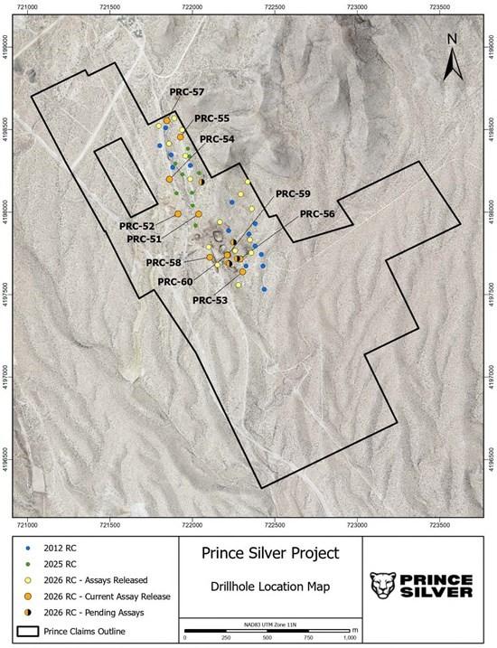
Figure 1 Drill Hole Location Map
The map shows drill hole locations and distinguishes the current assay release from holes with assays pending.
Quality Assurance and Quality Control
The RC assays in this release are supported by finalized ALS Geochemistry certificates. The Company inserts two certified reference standards, one blank, one pulp duplicate and one reject duplicate into a typical batch of 45 rock samples. Control-sample results are plotted and monitored, and returned pulps are selected for check assaying at a second independent laboratory.
Samples are shipped under chain-of-custody procedures to ALS in Reno, Nevada, for preparation and then to ALS in Vancouver, British Columbia, for analysis. Au is determined by Au-ICP22 fire assay, with additional follow-up assays where required; Ag and other elements are analyzed using the AuME-TL44 aqua regia method. Overlimit Ag, Mn, Zn and Pb results are determined using follow-up methods identified in the ALS certificates. Selected samples from different lithologies are also submitted for specific gravity measurements.
Qualified Person
The scientific and technical information in this news release has been reviewed and approved by Patrick Toth, P.Geo., the Company’s Exploration Manager and a non-independent Qualified Person as defined under NI 43-101.
About Prince Silver Corp.
Prince Silver Corp. is a mineral exploration company advancing its flagship Prince Silver Project in Nevada, USA. The Company is undertaking drilling, metallurgical studies and geological modelling toward a maiden NI 43-101 mineral resource estimate. Prince Silver also holds an interest in the Stampede Gap project in Nevada.
1911 Gold Corporation (TSX-V: AUMB) (OTCQX: AUMBF) (FRA: 2KY) is pleased... READ MORE
Prospector Metals Corp. (TSX-V: PPP) (OTCQB: PMCOF) (FSE: 1ET) p... READ MORE
Sun Summit Minerals Corp. (TSX-V: SMN) (OTCQB: SMREF) is please... READ MORE
Maiden Drilling at Lynx Expands Scale of Project Including 420 Me... READ MORE


