


![]()
Sun Summit Minerals Corp. (TSX-V: SMN) (OTCQB: SMREF) is pleased to report final analytical and petrographic results from the 2025 field program at its Theory Project, in the Toodoggone Mining District, north-central British Columbia.
The Theory Project borders Thesis Gold Inc.’s Ranch Project to the north and is located 10 km to the northwest of Sun Summit’s JD Project. Sun Summit has an exclusive option agreement with Eagle Plains Resources Ltd. to earn up to a 100% interest in the project, located in the highly prospective Toodoggone Mining District (for additional information on the Theory Project see the Company’s press release dated October 22, 2025).
Highlights:
New high-grade copper discovery: Saboteur Zone
Fred-DM-DMR Zone:
BEV Zone:
Table 1 2025 Rock Sample Highlights
| Sample | Zone | Cu % | Au g/t | Ag g/t |
| BLTHR051 | Fred/DM | 6.42 | 0.088 | 99.0 |
| JBTHR008 | Fred/DM | 0.65 | 12.60 | 3150.0 |
| LSTHR040 | Saboteur | 4.78 | 0.635 | 48.6 |
| JBTHR059 | Saboteur | 4.02 | 0.596 | 61.1 |
| MHTHR037 | Saboteur | 3.27 | 4.290 | 121.0 |
| JBTHR010 | Bev-N | 2.73 | 0.255 | 17.2 |
| LSTHR020 | Saboteur | 2.8 | 0.0025 | 7.4 |
| BLTHR029 | Bev-Main | 1.44 | 0.043 | 12.8 |
| THTHR032 | Bev-Main | 0.1 | 0.169 | 0.3 |
“We are pleased to announce very exciting results from the 2025 Theory exploration program”, said Niel Marotta, CEO of Sun Summit Minerals. “The work confirms the strong high-grade copper-gold potential at several of the known zones, and also at the newly defined Saboteur Zone, which likely hasn’t seen boots on the ground in more than 30 years.
Mapping and sampling at the BEV zone has established significant scale potential which remains open in all directions across the corridor. More fieldwork is warranted in the 2026 exploration season to define future drill targets, and we look forward to continuing to work with Eagle Plains and Terralogic as we advance the Theory Project towards its first-ever inaugural drill campaign.”
2025 Exploration Program
The 2025 exploration goals at the Theory Project were to identify and assess new areas of interest and to refine drill targets generated through integrating historical exploration data with new geophysical and geochemical surveys. Eagle Plains and Sun Summit commissioned TerraLogic Exploration Inc. of Cranbrook, BC. to design and execute the 2025 satellite (remote sensing) data acquisition, and field program.
2025 work included:
Comprehensive data interpretation and analyses is underway to define and prioritize targets for 2026 fieldwork and detailed IP geophysical surveys to generate and refine targets for future diamond drill testing.
Field Results
All primary targets of interest were prospected and geologically mapped and sampled. Most targets are underlain by mafic volcanic sequences of the Takla Group, with Jurassic aged Hazelton Group intermediate and mafic volcanics and related sediments encountered at the Stik, DAR and southernmost Bev areas. The volcanic stratigraphy is mostly homoclinal at scale of 100’s to 1000+ meters, with shallow dips (15-35°) towards the N or NE the most common, such that a layer-cake stratigraphy approximates the general structural layout of the property – a pattern that is also evident in the airborne RTP magnetics.
Many mineralized veins and fractures exploit bedding parallel structures, but there are also a significant number of steep mineralized structures with NE and NW strikes, with smaller subsets of E or N striking veins and fractures.
The Takla group stratigraphy comprises a repetitive sequence of fine mafic tuff, feldspar ± pyroxene crystal tuff with some pillow basalt, trachyitic basalt, and crystal-lithic lapilli ± bomb proximal vent basalts. More mapping is required to establish the detailed relationship between mineralized structures and volcanic stratigraphy.
The most common mineralized structures, comprise copper minerals (chalcopyrite, bornite, chalcocite) with lesser to equal proportions of pyrite or pyrrhotite, and associated malachite and azurite, in quartz-carbonate-epidote gangue. Azurite intensity appears coincident with presence of bornite and/or chalcocite. Wall rocks are usually moderately to strongly epidote-carbonate ± hematite altered, with, variable but commonly, high magnetics that is more a function of primary lithology (fine mafic tuffs are commonly the most magnetic). Barite veins are commonly spatially associated with these copper mineralized structures.
At the Bev showing, gossans are widespread with large zones ranging 10’s to over 100 meters. A quartz-sericite-pyrite (QSP) alteration-mineralization assemblage is typical of the gossans, and finely disseminated. The QSP alteration generally obscures protolith textures, but certainly does transcend lithological boundaries, having relatively steep orientation rather than being bedding parallel. Veining in this zone is quartz-pyrite ± sericite dominant.
Table 2 2025 Rock Sample Results – Summary Statistics
| 2025 Theory Rocks All | Au ppb | Ba ppm | As ppm | Cu ppm | Mo ppm | Pb ppm | Sb ppm | Zn ppm | Ag ppm |
| Count | 258 | 258 | 258 | 258 | 258 | 258 | 258 | 258 | 258 |
| Minimum | 2.5 | 10 | 0.1 | 2.1 | 0.12 | 0.8 | 0.07 | 8 | 0.01 |
| Maximum | 12600 | 10000 | 285 | 64200 | 404 | 5570 | 980 | 39900 | 3150 |
| Mean | 127.3 | 925.3 | 18.7 | 3940.9 | 4.2 | 86.0 | 8.3 | 305.5 | 21.0 |
| Median | 5.5 | 575 | 8.2 | 296 | 0.86 | 9 | 1.64 | 93.5 | 0.47 |
| Std Dev. | 843.6 | 1120.6 | 38.9 | 8875.0 | 25.8 | 411.0 | 62.4 | 2499.1 | 197.6 |
| 75 percentile | 25.25 | 1192.5 | 14.8 | 3252.5 | 1.9725 | 22 | 3.1325 | 160.25 | 3.6975 |
| 90 percentile | 149.8 | 2241 | 33.09 | 11365 | 4.652 | 104.05 | 8.426 | 245.3 | 21.38 |
| 95 percentile | 471 | 3003.5 | 77.93 | 25625 | 13.4625 | 436.15 | 17.06 | 431.85 | 61.12 |
| 99 percentile | 2673.4 | 5668.1 | 243.84 | 50629 | 49.309 | 1978.4 | 135.84 | 2887.85 | 219.85 |
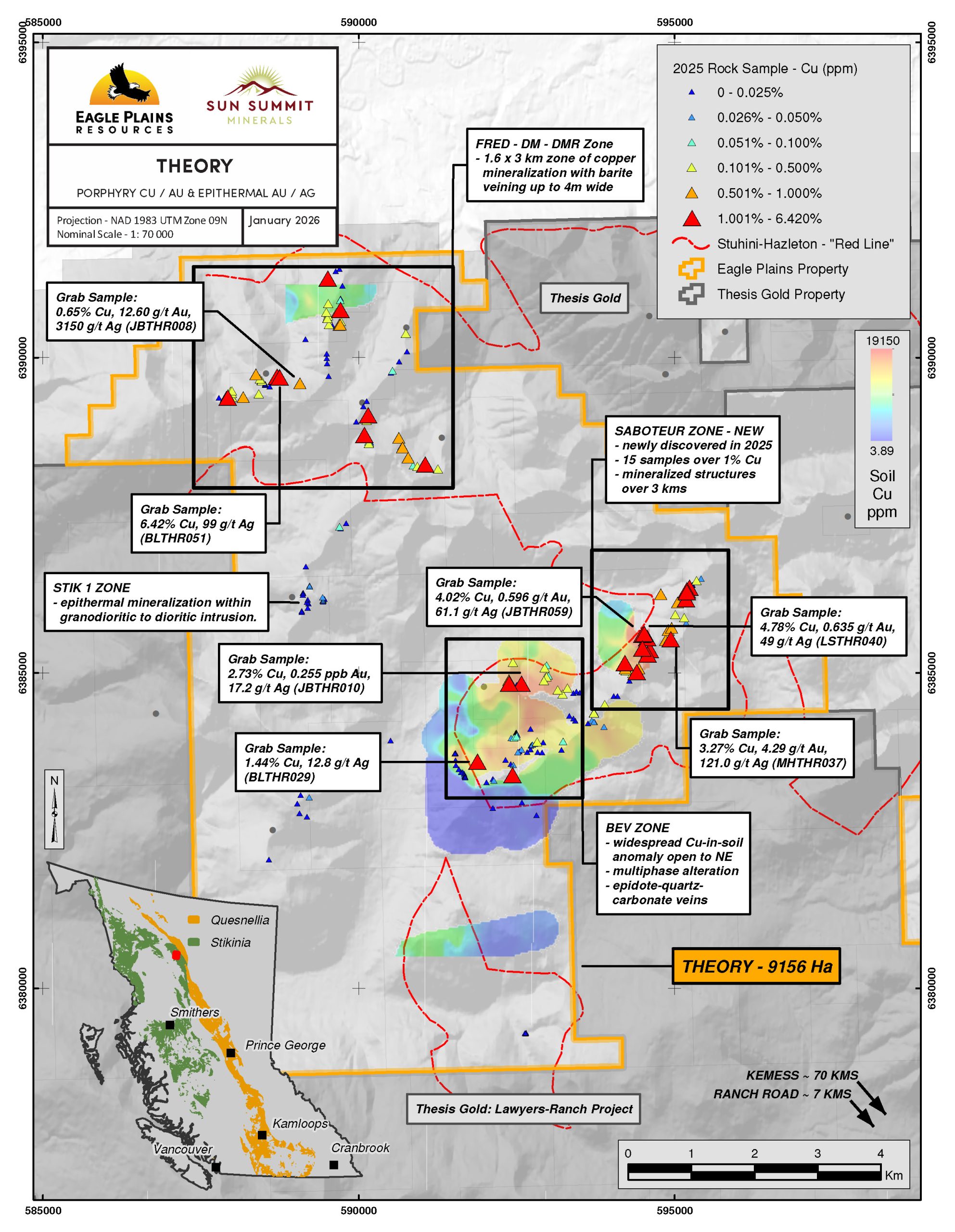
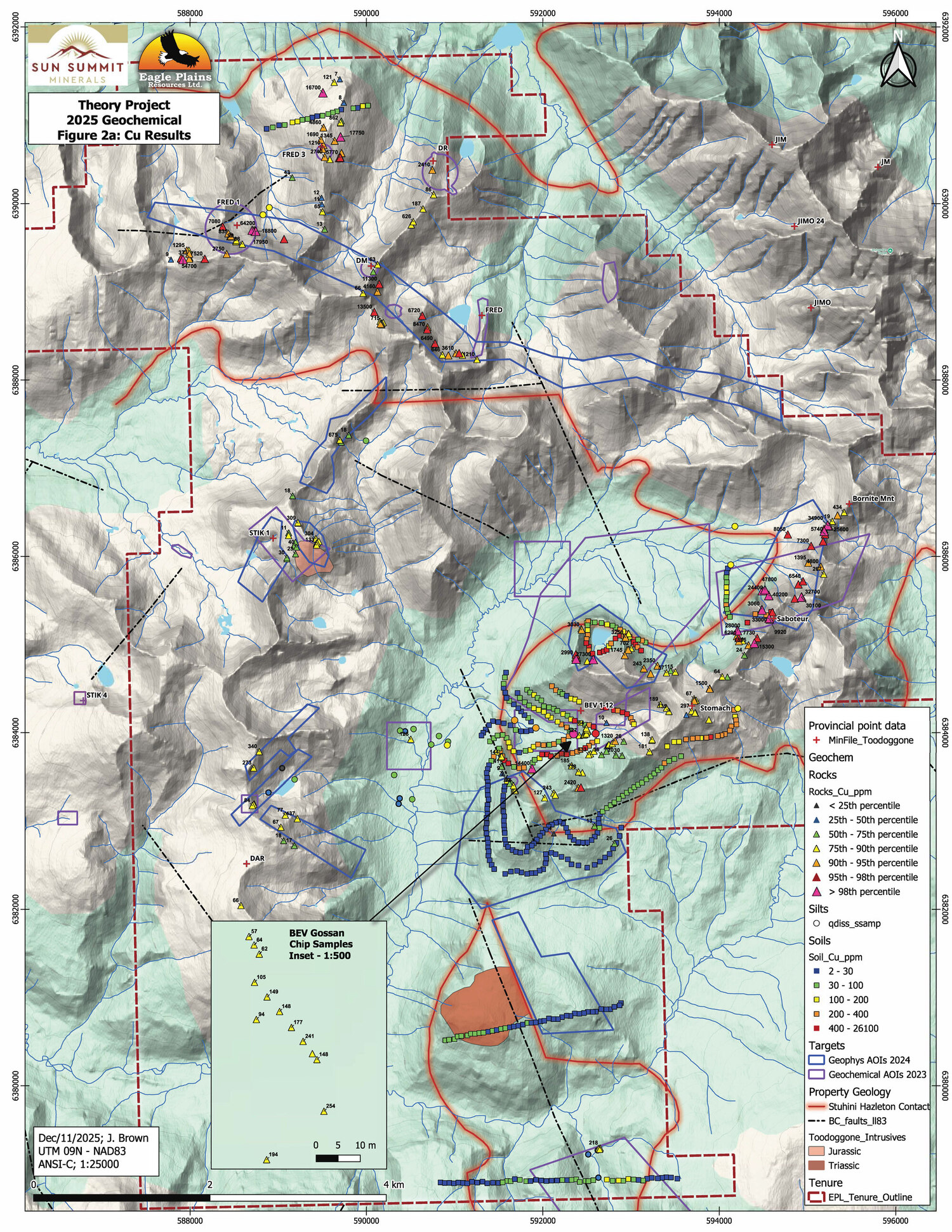
Saboteur Zone (Figures 2 and 3)
The newly discovered Saboteur Zone is defined by a 3 km long NE trending magnetic high with consistent copper mineralization (chalcopyrite, bornite and chalcocite) associated with epidote-quartz-carbonate veins and fractures. Highlights include grab samples LSTHR040 with 4.7% copper, 0.635 g/t gold, 49 g/t silver; JBTHR059 with 4.0% copper, 0.596 g/t gold, 61 g/t silver; and MHTHR037 with 3.3% copper, 4.290 g/t gold, 121 g/t silver.
Grab samples from the adjacent Provocateur and BEV-N targets include LSTHR020 with 2.8% copper, 0.0025 g/t gold, 7.4 g/t silver; and (Bev-N): JBTHR010 with 2.73% copper, 0.255 g/t gold, 17.2 g/t silver.
Soil samples collected on Saboteur peak returned a maximum of 2.61% copper, 0.410 g/t gold, and 10.4 g/t silver (MHTHD130).
BEV Zone (Figures 2 and 3)
The best grab sample from the BEV-main zone returned 1.44% copper, 0.043 g/t gold, 12.8 g/t silver (BLTHR029). Soil and stream-silt results from this main drainage at the Bev zone returned some of the best geochemical results of the 2025 program, defining a multi-element copper dominant geochemical anomaly approximately 1 km x 700 meter, open in three directions. Detailed geological mapping in the BEV area defined a broad zone of multiphase alteration associated with copper mineralization in epidote-quartz–carbonate veins, and peripheral quartz-sericite-pyrite (QSP) altered gossans, highlighting the possibility of a large buried porphyry system.
FRED-DM-DMR Zone (Figures 2 and 3)
Prospecting at the Fred-DM area focused on an approximately 5 km linear magnetic high-low transition zone. Copper mineralization in veins and fractures are associated with NNE trending barite veins, up to 4m in width, that are exposed over 150-meter length. Grab samples from Fred-DM corridor returned the highest values from the 2025 program. Highlight samples include BLTHR051 with 6.42% copper, 0.088 g/t gold, 99 g/t silver; and JBTHR008 with 0.65% copper, 12.6 g/t gold, 3,150 g/t silver. Soil sampling and prospecting indicate that the strike length of the barite mineralization exceeds over 1 kilometer.
STIK 1
Fieldwork at the STIK1 identified epithermal style alteration and mineralization within a granodioritic to dioritic intrusion, as well as in metasediments along the intrusive contact.
Petrographic Results and Interpretation
Twelve select samples were prepared by Precision Petrographics of Vancouver BC for thin section analyses and interpretation. The petrographic work identified strong epidote-chlorite-carbonate alteration directly associated with hypogene copper mineralization (chalcopyrite – bornite – chalcocite). This type of mineralization and alteration assemblage is interpreted to represent the inner shell of a porphyry system, which may indicate a proximal source for some of the Theory mineralization.
Next Steps
Planning is now underway for a significant exploration program across the Theory Project in 2026. Details of the program will be released once targets ranks are prioritised and all new analytical data have been interpreted. A priority focus will be on the BEV to Saboteur trend of strong copper mineralization.
Table 3 Significant 2025 Silt Sample Results
| Sample_# | Sample | Ag_ppm | Au_ppb | Cu_ppm | Mo_ppm |
| MHTHS007 | Silt | 0.40 | 84.30 | 1385 | 20.5 |
| MHTHS008 | Silt | 0.67 | 25.60 | 986 | 1.1 |
| JBTHS005 | Silt | 0.38 | 60.50 | 954 | 12.2 |
| LSTHS004 | Silt | 0.37 | 48.70 | 826 | 7.7 |
| MHTHS009 | Silt | 0.96 | 49.60 | 382 | 1.3 |
Table 4 Significant 2025 Soil Sample Results
| Sample_# | Sample | Ag_ppm | Au_ppb | Cu_ppm | Mo_ppm |
| MHTHD130 | Soil | 10.50 | 410.00 | 26100 | 0.9 |
| MHTHD011 | Soil | 0.82 | 21.60 | 833 | 0.8 |
| MHTHD058 | Soil | 0.47 | 12.60 | 798 | 2.4 |
| MHTHD034 | Soil | 0.25 | 3.20 | 794 | 0.8 |
| MHTHD009 | Soil | 0.17 | 11.20 | 749 | 0.5 |
| MHTHD068 | Soil | 0.81 | 14.80 | 634 | 1.3 |
![]()
Figure 1. Map of the Toodoggone District showing the location of the Theory Project in relation to the Company’s flagship JD Project and other development and exploration projects. Data sourced from Thesis Gold Inc., TDG Gold Corp. and Centerra Gold Inc.’s respective corporate websites. The QP has been unable to verify the information and the information is not necessarily indicative to the mineralization on the property that is the subject of the disclosure.
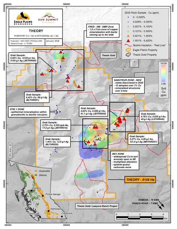
Figure 2. Highlighted sample locations and values by Zone at the Theory Project.
![]()
Figure 3. Cu results at the Theory Project.
![]()
Figure 4. Au results at the Theory Project
Quality Assurance and Quality Control
Rock and soil/silt samples collected during the 2025 surface program were submitted to ALS Geochemistry in North Vancouver, BC – an ISO/IEC 17025–accredited laboratory. Samples were sealed in the field, stored securely, and transported by Terralogic personnel to maintain chain of custody. Analytical methods for rocks included full multi-element characterization by four acid digestion with ICP finish (ALS method ME-MS61). Gold was analyzed by 30 g fire assay with AAS finish (ALS method Au AA23). Samples returning >10 g/t Au were re assayed using fire assay with gravimetric finish (ALS method Au GRA21). Soils and silts were analyzed via full multi-element characterization by ICP ultra-trace analysis on aqua-regia digestion (ALS package: ST43-PKG). The ST43-PKG includes ICP method ME-MS41, plus supertrace gold analysis on a larger 25g aliquot. ALS used a number of internal gold and copper standards all of which passed ALS internal screening.
National Instrument 43-101 Disclosure
This news release has been reviewed and approved by Sun Summit’s Vice President Exploration, Ken MacDonald, P. Geo., a “Qualified Person” as defined in National Instrument 43-101 Standards of Disclosure for Mineral Projects of the Canadian Securities Administrators. Mr. MacDonald has verified the data disclosed in this press release, including the sampling, analytical and test data underlying this information that has been collected by Terralogic. Verification procedures include industry standard quality control practices. Some technical information contained in this release is historical in nature and has been compiled from public sources believed to be accurate. The historical technical information has not been verified by Sun Summit and may in some instances be unverifiable dependent on the existence of historical drill core and grab samples. Management cautions that past results are not necessarily indicative of the results that may be achieved on the property.
Community Engagement
Sun Summit is engaging with First Nations on whose territory our projects are located and is discussing their interests and identifying contract and work opportunities, as well as opportunities to support community initiatives. The Company looks forward to continuing to work with local and regional First Nations with ongoing exploration.
December Private Placement
Further to the Company’s news release dated December 23, 2025, the Company announces an update to the compensation provided to finders in connection with the non-brokered private placement closed on December 23, 2025 (the “Private Placement“). In connection with the Private Placement, the Company paid aggregate cash finder’s fees of $305,130 and granted an aggregate of 3,101,900 non-transferable common share purchase warrants of the Company (each, a “Finder Warrant“) to arm’s length finders of the Company in connection with the Private Placement. Each Finder Warrant entitles the holder thereof to purchase one common share in the capital of the Company, at an exercise price of $0.14 per common share until December 23, 2027.
About the Theory Project
The 9,676ha Theory Project is located in northern BC within the Toodoggone Mining District. The district is endowed with both epithermal gold and porphyry copper-gold deposits, most notably the past producing Kemess Mine owned by Centerra Gold. The Omineca Resource Road provides access to the region from Mackenzie, BC. Recent road upgrades completed in 2023 by Thesis Gold on their Lawyers-Ranch Project brought road access to within 8 kms of the Theory Project.
Geology in the Theory region is primarily comprised of lower Jurassic Hazelton Group volcanics which unconformably overlie late Triassic Takla Group volcanics. The entire package of rocks is intruded by late Triassic and early Jurassic stocks. The majority of the Theory property encompasses the highly prospective Triassic-Jurassic unconformity (~200 Ma), termed by the BC Geologic Survey as the ‘Red-Line’, which is known to have a high spatial correlation to many of the known deposits throughout the Golden Triangle and Toodoggone.
Exploration by previous operators has been intermittent since the mid-1960’s and regional government surveys are sparse, however encouraging mineralization and alteration commonly associated with both epithermal and porphyry systems has been documented.
The most significant documented work was completed in 1988 in the north and west areas of the Theory project area. Work consisted primarily of alpine ridge and subalpine prospecting traverses as well as reconnaissance soil sample lines in areas where no outcrop was present.
This work documented occurrences of low-sulphidation epithermal-related mineralization including quartz-barite veins with up to 8.2 g/t Au, 195 g/t Ag, and 6.2% Cu at the DM occurrence (BC Minfile 094E 231)1; and a quartz carbonate vein system with up to 6.8 g/t Au and 1,480 g/t Ag at the Fred-1 occurrence (BC Minfile 094E 402)2. The BEV occurrences (BC Minfile 094E 259)3, interpreted as a Cu-Au porphyry target, returned select historical rock results up to 0.47% Cu, 10.5 g/t Ag, and 0.13 g/t Au. Detailed soils revealed a 1.6 by 2-kilometre copper-in-soil anomaly with peak soil results to 920 ppm Cu4. Very little work is documented in the south and eastern parts of the property.
In late 2023 Eagle Plains acquired the property through staking and third-party agreements. After undertaking initial compilation and interpretation of historical data on the project, Eagle Plains completed a property wide, high resolution airborne magnetic and radiometric survey in July 2024.
About the JD Project
The JD Project is located in the Toodoggone mining district in north-central British Columbia, a highly prospective deposit-rich mineral trend. The project covers an area of over 15,000 hectares and is in close proximity to active exploration and development projects, such as Thesis Gold’s Lawyers and Ranch projects, TDG Gold’s Baker-Shasta projects, Amarc Resource’s AuRORA project, Centerra Gold’s Kemess East and Underground projects, as well as the past-producing Kemess open pit copper-gold mine (Figure 5).
The project is 450 kilometres northwest of the city of Prince George, and 25 kilometres north of the Sturdee airstrip. It is proximal to existing infrastructure in place to support the past-producing Kemess mine, including roads and a hydroelectric power line.
The JD Project is in a favourable geological environment characterized by both high-grade epithermal gold and silver mineralization, as well as porphyry-related copper and gold mineralization. Some historical exploration, including drilling, geochemistry and geophysics, has been carried out on the property, however the project area is largely underexplored.
About Sun Summit
Sun Summit Minerals is a mineral exploration company focused on the discovery, expansion and advancement of district scale gold and copper assets in British Columbia. The Company’s diverse portfolio includes the JD and Theory projects in the Toodoggone region of north-central B.C., and the Buck Project in central B.C.
Further details are available at www.sunsummitminerals.com.
References
1Aussant, C.H. & Davis, J.W. (1988): Geological, Geochemical, and Prospecting Report on the ‘Toodoggone Properties’, Liard Mining Division, British Columbia; for Prolific Resources Ltd., BC Assessment Report #18465
2Beattie, B.C. (1988): Reconnaissance Geological and Prospecting Report on the Fred 1 Mineral Claim, Liard Mining Division, British Columbia; for Prolific Resources Ltd., BC Assessment Report #17247
3Birkeland, A.O. (2007): Geochemical – Prospecting – Geological Report on the Gaucho Claim group, Omineca Mining Division, British Columbia; BC Assessment Report #29313
4Dyson, C. (1974): Bev 1 – 12 Mineral Claims, Liard Mining Division, British Columbia; for UMEX Corp., BC Property File #PF016736
Link to Figures
Hudbay Minerals Inc. (TSX:HBM) (NYSE: HBM) today released its ann... READ MORE
Strategic acquisition of an established operating gold mine, loca... READ MORE
Cerro de Pasco Resources Inc. (TSX-V: CDPR) (OTCQB: GPPRF) (FRA: ... READ MORE
The Garneau Titanium Project Features Ilmenite-Rich Boulder with ... READ MORE
ValOre Metals Corp. (TSX‐V: VO) (OTCQB: KVLQF) (Frankfurt: KEQ0... READ MORE


