


![]()
Sun Summit Minerals Corp. (TSX-V: SMN) (OTCQB: SMREF) is pleased to provide an overview of its upcoming 2026 exploration drill program at the JD Project, Toodoggone Mining District, north-central British Columbia. Drilling is set to commence in early June with over 10,000 meters planned across the Creek and Finn zones.
Highlights:
Drilling scheduled for June: Preparations are underway to mobilize crews to the project in the coming weeks. Drill crews will arrive once camp is re-opened with drilling anticipated to begin in early June.
“We are excited to kick off the most significant drill program at JD since the late 1990s, as we advance towards an inaugural mineral resource estimate, expected in Q1 of 2027,” said Niel Marotta, CEO of Sun Summit Minerals. “The 2026 drill program has been carefully designed to achieve a clear goal of defining a significant resource. Our 3D modeling to date suggests that drilling has defined the upper levels of potentially much larger systems, which remain open at depth and along strike — pointing to meaningful expansion potential at both the Finn and Creek zones. With 10,000 metres of planned drilling, metallurgical testing underway, and a mineral resource estimate targeted for Q1 2027, we will continue to unlock value at JD and capitalize on exploration success in the world-class Toodoggone mining district.”
Significant Drill Program
Drilling in 2026 at the JD project is designed with two primary goals, 1) establish an inaugural mineral resource estimate for the Finn and Creek zones, and 2) explore the lateral and vertical extents of near surface, epithermal-related gold-silver-base metal mineralization at both targets.
2026 drill program details include:
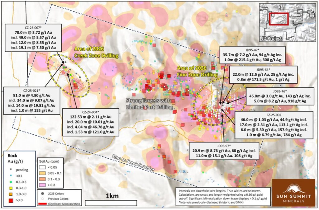
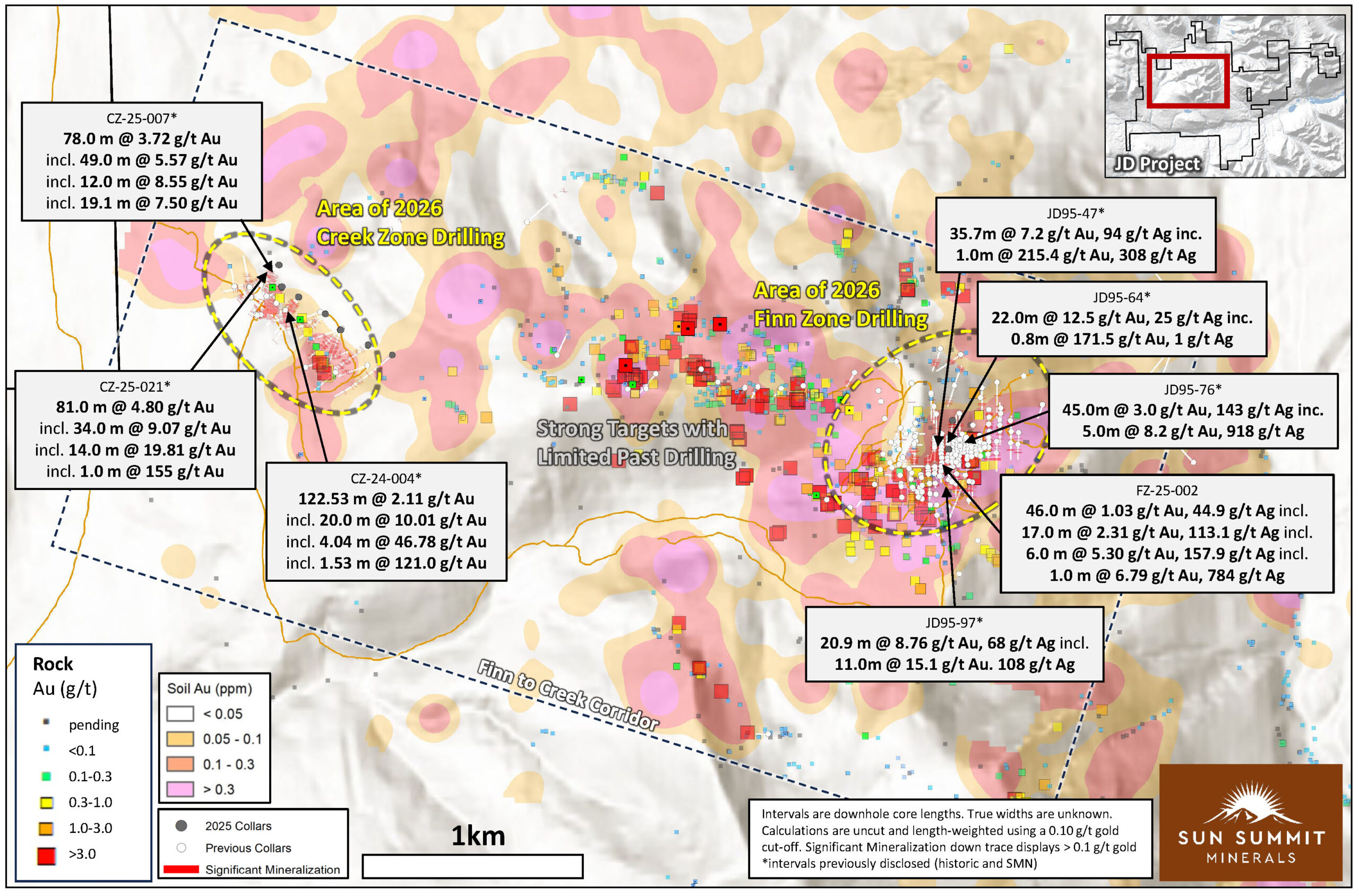
Figure 1. Plan map highlighting the ~4.5 km Finn to Creek Corridor showing drill collar locations as well as results from recent and historical rock and soil geochemical surveys (see October 29th, 2025 news release). The areas marked by the dashed yellow ovals will be the focus for the majority of the 2026 drilling. Targets between will be ranked and prioritised for potential drill testing. See references for sources of historical data.
Mineral Resource Estimate
Over 46,000 meters of drilling in 366 drill holes, including results from 2024 and 2025 by Sun Summit, have been completed across the JD project. Most of the previous drilling was focused on the Finn and Creek zones (Figure 1). These compiled data, together with results from 2026 drilling and results from an ongoing metallurgical testing (see April 8th, 2026 News Release), will form the basis of the mineral resource estimate, planned for Q1 of 2027.
The Company has engaged Dahrouge Geological Consulting USA Ltd. to complete an inaugural mineral resource estimate for the JD Project. The MRE will include historical and modern drilling from the Finn and Creek epithermal-related gold-silver mineralized zones. Dahrouge will review and validate the project database and 3D geological domains and will also assist with drill targeting, compositing, statistical analysis, and block model estimation using the supplied geological interpretations. The completed MRE will be classified and reported in accordance with NI 43-101 – Standards of Disclosure for Mineral Projects and Canadian Institute of Mining, Metallurgy and Petroleum standards.
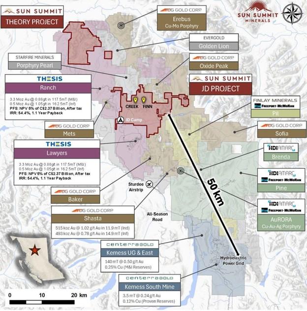
Figure 2. Map of the Toodoggone District showing the location of the JD Project in relation to other development and exploration projects. Data sourced from Thesis Gold & Silver Inc., TDG Gold Corp. and Centerra Gold Inc.’s respective corporate websites. The qualified person has been unable to verify the information and that the information is not necessarily indicative to the mineralization on the property that is the subject of the disclosure.
National Instrument 43-101 Disclosure
This news release has been reviewed and approved by Sun Summit’s Vice President Exploration, Ken MacDonald, P. Geo., a “Qualified Person” as defined in National Instrument 43-101 Standards of Disclosure for Mineral Projects of the Canadian Securities Administrators. Mr. MacDonald has verified the data disclosed in this press release, including the sampling, analytical and test data underlying this information that has been collected by Sun Summit. Verification procedures include industry standard quality control practices. Some technical information contained in this press release is historical in nature and has been compiled from public sources believed to be accurate. The historical technical information has not been verified by Sun Summit and may in some instances be unverifiable dependent on the existence of historical drill core and grab samples. Management cautions that past results are not necessarily indicative of the results that may be achieved on the property.
About Dahrouge USA.
Dahrouge USA is a leading and highly experienced group of qualified professional geologists and mining engineers who provide independent consulting services to the mining and exploration sectors. Jacob Anderson (CPG) is the independent qualified person who will lead the modeling validation and estimation team for Dahrouge.
Mr. Anderson is a resource geologist and is a Certified Professional Geologist (CPG) with the American Institute of Professional Geologists (AIPG). He has significant experience in gold deposits, including stratigraphic, epithermal, vein hosted and porphyry. (1)
(1) For clarity, Mr. Anderson has not independently verified and is not responsible for the technical content and disclosure in this news release. Thetechnical content herein was reviewed and approved by Sun Summit’s Vice President Exploration, Ken MacDonald, P. Geo., as described above in “National Instrument 43-101 Disclosure”.
Community Engagement
Sun Summit is engaging with First Nations on whose territory our projects are located and is discussing their interests and identifying contract and work opportunities, as well as opportunities to support community initiatives. The Company looks forward to continuing to work with local and regional First Nations with ongoing exploration.
About the JD Project
The JD Project is located in the Toodoggone mining district in north-central British Columbia, a highly prospective deposit-rich mineral trend. The project covers an area of over 15,000 hectares and is in close proximity to active exploration and development projects, such as Thesis Gold and Silver Inc.’s Lawyers and Ranch projects, TDG Gold Corp’s Baker-Shasta projects, Amarc Resource Ltd.’s AuRORA project, Centerra’s Gold Inc’s Kemess East and Underground projects, as well as the past-producing Kemess open pit copper-gold mine (Figure 2).
The project is 450 kilometres northwest of the city of Prince George, and 25 kilometres north of the Sturdee airstrip. It is proximal to existing infrastructure in place to support the past-producing Kemess mine, including roads and a hydroelectric power line.
The JD Project is in a favourable geological environment characterized by both high-grade epithermal gold and silver mineralization, as well as porphyry-related copper and gold mineralization. Some historical exploration, including drilling, geochemistry and geophysics, has been carried out on the property, however the project area is largely underexplored.
About Sun Summit
Sun Summit Minerals is a mineral exploration company focused on the discovery, expansion, and advancement of district-scale gold and copper assets in British Columbia. The Company’s portfolio is anchored by its flagship JD Project, alongside the Theory Project in the prolific Toodoggone region of north-central BC, and the Buck Project in central B.C.
References
CPM Group’s 10-Year Copper Outlook are now available. ... READ MORE
Arizona Gold and Silver Inc. (TSX-V: AZS) (OTCQB: AZASF) is ple... READ MORE
Brixton Metals Corporation (TSX-V: BBB) (OTCQX: BBBXF) is pleased... READ MORE
Valkea Resources Corp. (TSX-V: OZ) is pleased to announce the clo... READ MORE
Tiger Gold Corp. (TSX-V: TIGR) (FSE: D150) (OTCQB: TGRGF) is plea... READ MORE


