








Sonoro Gold Corp. (TSX-V: SGO | OTCQB: SMOFF | FRA: 23SP) is pleased to announce that drilling has extended near-surface gold mineralization at Diana and intersected gold-silver mineralization beneath the historic El Batamote mine. The Company has now completed 104 reverse circulation drill holes totaling 21,345.12 meters as part of its ongoing 50,000-meter exploration drilling program at the Company’s flagship Cerro Caliche gold project in Sonora, Mexico.
HIGHLIGHTS
Diana Mineralization Extended: Step-out holes collared up to approximately 245 meters east to southeast of the previously announced higher-grade SCR-387 drill hole extended mineralization with all 21 new drill holes returning gold above the cut-off. Near surface mineralization began within the first 30m downhole in 20 of the 21 drill holes.
El Batamote Gold-Silver Intercepts: Initial five drill holes below the historical workings intersected high-grade gold-silver mineralization, indicative of higher level epithermal-style mineralization often seen above high-grade feeder veins.
The recently acquired Diana and El Batamote concessions are located approximately two kilometers north of the proposed open-pit, heap leach mining operation as outlined in a Preliminary Economic Assessment (the “PEA”) filed April 24, 2026. Results from 21 drill holes completed at Diana and five drill holes completed at El Batamote support the Company’s strategy of acquiring and systematically exploring prospective ground surrounding Cerro Caliche’s current mineral resources.
“Drilling at Diana continues to build upon our previous higher-grade gold intercepts and improve our understanding of the mineralized corridors extending northward from El Rincón and Bellotoso. Results at El Batamote support the interpreted continuation of these corridors across the post-mineral fault into our recently acquired northern concessions,” said Sonoro President & CEO Kenneth MacLeod. “All 26 holes in this release intersected gold mineralization, with mineralized intervals starting within the first 30 meters downhole in 22 of them. These results reinforce our decision to acquire and explore this ground. The mineralization reported here is not included in the mine plan evaluated in our current PEA but offers potential for future resource growth, subject to further exploration and technical evaluation. We remain focused on advancing permitting for Cerro Caliche, and we have only begun to explore the concessions acquired in 2026.”
The map below illustrates the proposed mine footprint, including the open pits, the original 1,350-hectare property boundary, the Diana concession, interpreted mineralized corridors, and mapped and projected faults. Drill hole locations are differentiated by category.
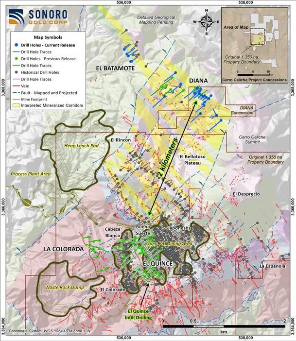
Figure 1: Cerro Caliche Gold Project
Mineralized Corridors
In the northern part of the Cerro Caliche project, a northeast-trending post-mineral fault separates the Bellotoso–Diana plateau from El Batamote located at the foot of the plateau. The El Batamote block is interpreted to have been downthrown relative to the plateau, and this structural setting suggests concealed extensions of the gold-bearing vein systems identified at Cerro Caliche and Diana. Further drilling is required to confirm extensions are present at depth, as well as continuity and grade.
The plateau is capped by erosion-resistant rhyolite domes. Extensive geological mapping has identified northwest-trending veins, breccias and rhyolite dikes with characteristics similar to those associated with gold mineralization in the proposed open-pit area. The recently completed 26 drill holes investigated two important inquiries at Diana and El Batamote.
First, drilling investigated whether the northwest-trending vein corridors at the top of the Diana plateau, located northeast of El Rincón and Bellotoso, represent extensions of the same mineralized structural system. Drilling followed up on the previously reported higher-grade intercepts and included both step-out drilling and tests of mineralization at depth.
Second, drilling at El Batamote investigated whether the interpreted extensions of Diana’s mineralized vein corridors across the post-mineral fault and beneath the historic workings at El Batamote host gold mineralization. El Batamote lies approximately 1.2 km west-northwest of Diana, at an elevation approximately 300m lower than the main Diana drilling area.
Below are selected drill results containing interval grading of 1.0 g/t Au or greater.
| Table 1: Cerro Caliche Project, Holes Composites with Cut-off 0.13 g/t Au | |||||||
| Hole | Target | From | To | Interval | Au | Ag | |
| Meters | g/t | g/t | |||||
| SCR-399 | Diana | 27.43 | 36.58 | 9.15 | 1.286 | 0.56 | |
| includes | 28.96 | 33.53 | 4.57 | 2.366 | 0.67 | ||
| SCR-404 | Diana | 1.52 | 51.82 | 50.30 | 0.823 | 2.30 | |
| includes | 30.48 | 32.00 | 1.52 | 9.372 | 8.50 | ||
| SCR-406 | El Batamote | 67.06 | 86.87 | 19.81 | 1.127 | 15.10 | |
| includes | 74.68 | 76.20 | 1.52 | 3.603 | 58.50 | ||
| includes | 80.77 | 85.34 | 4.57 | 2.350 | 12.70 | ||
| SCR-408a | El Batamote | 70.10 | 73.15 | 3.05 | 1.441 | 8.10 | |
| and | 89.92 | 92.96 | 3.04 | 1.668 | 6.90 | ||
| SCR-419 | Diana | 32.00 | 44.20 | 12.20 | 0.763 | 2.40 | |
| includes | 33.53 | 35.05 | 1.52 | 4.016 | 4.80 | ||
| SCR-420 | Diana | 0.00 | 28.96 | 28.96 | 0.440 | 1.20 | |
| includes | 4.57 | 7.62 | 3.05 | 1.454 | 2.20 | ||
| SCR-422 | Diana | 7.62 | 57.91 | 50.29 | 0.513 | 2.50 | |
| includes | 18.29 | 24.38 | 6.09 | 2.038 | 8.40 | ||
| SCR-423 | Diana | 16.76 | 102.11 | 85.35 | 0.333 | 1.00 | |
Reported intervals are downhole lengths, not true widths. Reported grades are uncut averages and includes identified subintervals within a larger interval, not additional intercepts. The 3.05 m highlight in SCR-408a is included within the 4.58m interval as shown in Table 2 below.
The below map illustrates the drill hole locations for the Diana and El Batamote areas and includes selected gold and silver intercepts, rhyolite dikes and domes, Jurassic sedimentary rocks, veins, mapped and projected faults, and artisanal workings. Drill holes are differentiated by category.
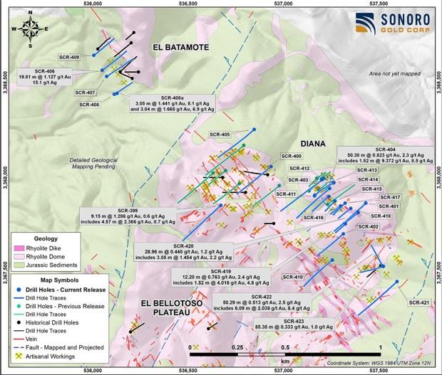
Figure 2: Dill Hole locations
Diana hosts gold mineralization, including higher-grade intervals, with similar structural characteristics to those observed at El Rincón and Bellotoso, areas previously described as marking the northern extent of the Cerro Caliche mineral resource. El Batamote lies on the opposite side of a post-mineral fault and also hosts gold-silver mineralization. Together, these results support the interpretation that Cerro Caliche’s mineralized structural corridors extend northward onto the recently acquired concessions.
The mineralization reported in the Diana and El Batamote areas is not included in the current MRE or the mine plan outlines in the PEA. These results could support future mineral resource updates and subsequent economic assessments, subject to further exploration, resource estimation and technical evaluation.
Diana Mineralized Zone
At the Diana mineralized zone, the Company completed 21 drill holes over 4,690.84 m confirming the expansion of at or near surface gold mineralization. All 21 holes returned intervals grading at or above the 0.13 g/t Au reporting cut-off, with qualifying intervals starting within the first 30m downhole in 20 of the 21 drill holes.
A total of 10 step-out drill holes follow up on previously reported higher-grade drilling results. Drill hole SCR-412 was collared approximately 97m northeast of previously disclosed drill hole SCR-387 which returned 28.95m @ 2.598 g/t Au, including 13.72m @ 5.101 g/t Au, while drill holes SCR-414 to SCR-420 were collared approximately 74 to 245m east to southeast of SCR-387. These distances are horizontal collar-to-collar measurements. SCR-411 and SCR-413 were collared close and at steeper inclinations to SCR-387 and previously disclosed SCR-391 which returned 32m @ 1.846 g/t Au, including 4.57m @ 10.430 g/t Au.
Highlights:
A total of eight drill holes tested the corridors at depth and along strike from 274.32m to 384.05m downhole. Drill hole SCR-404 returned a near-surface interval of 50.30m @ 0.82 g/t Au from 1.52m to 51.82 m, including 1.52m @ 9.37 g/t Au and 8.5 g/t Ag from 30.48m to 32.00m.
Drill hole SCR-399 returned 9.15m @ 1.29 g/t Au from 27.43m to 36.58m, including 4.57m @ 2.37 g/t Au from 28.96m to 33.53m, whereas drill hole SCR-421 returned 21.34m @ 0.28 g/t Au from 19.81m to 41.15m.
Below approximately 60m downhole, results generally returned shorter mineralized intervals. Notable results include drill hole SCR-402 which returned 3.05m @ 0.93 g/t Au from 190.50m to 193.55m, including 1.52m @ 1.67 g/t Au from 190.50m to 192.02 m, and drill hole SCR-404 which returned 1.53m @ 1.11 g/t Au from 92.96m to 94.49m. These intercepts demonstrate the presence of gold mineralization at depth, but further drilling is required to establish its continuity and test for higher-grade shoots.
Drill hole SCR-422 returned 50.29m @ 0.51 g/t Au from 7.62 to 57.91m downhole, including 6.09m @ 2.04 g/t Au from 18.29 to 24.38m. Drill hole SCR-423 returned 85.35m @ 0.33 g/t Au from 16.76m to 102.11m, the longest mineralized interval reported at Diana from the 21 drill holes.
El Batamote Mineralized Zone
Drilling at the historic El Batamote mine site, located approximately 1.2 km west-northwest of Diana, hosts mineralization interpreted to represent a continuation of the Diana mineralized corridors within a block downthrown by post-mineral faulting.
As previously disclosed, the Company acquired data from prior drilling at El Batamote completed by Paget Southern Resources in 2012. The historical data was used to assist in the development of the current RC drilling program at El Batamote.
The Company completed five drill holes over 970.78m at the historic workings which all intersected gold-silver mineralization. El Batamote sits at the foot of the Bellotoso–Diana plateau, at an elevation approximately 300m lower than the main Diana drilling area. All five holes returned mineralized intervals within the approximate 45–95m downhole range, with additional intervals intersected at or near surface and at greater downhole depths. Assuming a constant hole inclination of 45°, the 45–95m downhole range corresponds to approximately 32–67m vertically below the respective collar elevations.
These vertical distances are referenced to each collar elevation and do not necessarily represent depths below the local topographic surface.
Reported mineralized intervals generally demonstrate higher silver-to-gold grade ratios at El Batamote than at Diana, although the ratios vary between intervals.
Highlights:
Results at El Batamote support the interpretation that the Cerro Caliche mineralized corridors extend across the post-mineral fault into the northern concessions. The interpreted downthrown block may host concealed extensions of the vein systems identified at Cerro Caliche and Diana. The higher silver-to-gold ratios reported in parts of El Batamote do not, on their own, establish its vertical position within the mineralizing system. Further structural, mineralogical and geochemical evaluation, together with drilling, is required to test the potential for additional mineralization and higher-grade gold zones at depth.
Next Steps in Exploration
Below are selected drill results containing interval grading of 1.0 g/t Au or greater.
| Table 2: Cerro Caliche Project, Holes Composites with Cut-off 0.13 g/t Au | |||||||
| Hole | Target | From | To | Interval | Au | Ag | |
| Meters | g/t | g/t | |||||
| SCR-399 | Diana | 27.43 | 36.58 | 9.15 | 1.286 | 0.56 | |
| includes | 28.96 | 33.53 | 4.57 | 2.366 | 0.67 | ||
| SCR-401 | Diana | 13.72 | 19.81 | 6.09 | 0.550 | 1.20 | |
| includes | 13.72 | 15.24 | 1.52 | 1.555 | 3.20 | ||
| SCR-403 | Diana | 47.24 | 53.34 | 6.10 | 0.738 | 2.30 | |
| includes | 48.77 | 50.29 | 1.52 | 2.150 | 5.90 | ||
| SCR-404 | Diana | 1.52 | 51.82 | 50.30 | 0.823 | 2.30 | |
| includes | 7.62 | 9.14 | 1.52 | 1.219 | 3.30 | ||
| includes | 15.24 | 16.76 | 1.52 | 1.572 | 3.60 | ||
| includes | 22.86 | 24.38 | 1.52 | 1.001 | 0.50 | ||
| includes | 30.48 | 32.00 | 1.52 | 9.372 | 8.50 | ||
| includes | 35.05 | 36.58 | 1.53 | 1.436 | 1.70 | ||
| includes | 50.29 | 51.82 | 1.53 | 1.373 | 0.30 | ||
| and | 92.96 | 94.49 | 1.53 | 1.114 | 1.30 | ||
| SCR-406 | El Batamote | 67.06 | 86.87 | 19.81 | 1.127 | 15.10 | |
| includes | 74.68 | 76.20 | 1.52 | 3.603 | 58.50 | ||
| includes | 80.77 | 85.34 | 4.57 | 2.350 | 12.70 | ||
| SCR-408a | El Batamote | 70.10 | 74.68 | 4.58 | 1.089 | 8.50 | |
| and | 89.92 | 92.96 | 3.04 | 1.668 | 6.90 | ||
| includes | 89.92 | 91.44 | 1.52 | 3.033 | 8.50 | ||
| 71.63 | 86.87 | 15.24 | 0.713 | 10.10 | |||
| SCR-409 | El Batamote | includes | 74.68 | 77.72 | 3.04 | 1.769 | 28.40 |
| and | 123.44 | 131.06 | 7.62 | 0.345 | 6.40 | ||
| includes | 126.49 | 128.02 | 1.53 | 1.086 | 3.50 | ||
| 13.72 | 38.10 | 24.38 | 0.320 | 0.30 | |||
| SCR-411 | Diana | 24.38 | 45.72 | 21.34 | 0.501 | 0.90 | |
| SCR-414 | Diana | includes | 38.10 | 41.15 | 3.05 | 1.349 | 1.40 |
| and | 53.34 | 65.53 | 12.19 | 0.397 | 0.70 | ||
| 12.19 | 28.96 | 16.77 | 0.333 | 0.60 | |||
| SCR-415 | Diana | and | 56.39 | 59.44 | 3.05 | 1.500 | 7.70 |
| includes | 56.39 | 57.91 | 1.52 | 2.824 | 13.50 | ||
| 1.52 | 28.96 | 27.44 | 0.224 | 0.60 | |||
| SCR-416 | Diana | 1.52 | 22.86 | 21.34 | 0.393 | 0.70 | |
| SCR-417 | Diana | 0.00 | 32.00 | 32.00 | 0.347 | 0.70 | |
| SCR-418 | Diana | 32.00 | 44.20 | 12.20 | 0.763 | 2.40 | |
| SCR-419 | Diana | includes | 33.53 | 35.05 | 1.52 | 4.016 | 4.80 |
| 0.00 | 28.96 | 28.96 | 0.440 | 1.20 | |||
| SCR-420 | Diana | includes | 4.57 | 7.62 | 3.05 | 1.454 | 2.20 |
| and | 92.96 | 94.49 | 1.53 | 1.022 | 0.40 | ||
| 19.81 | 41.15 | 21.34 | 0.279 | 2.30 | |||
| SCR-421 | Diana | 7.62 | 57.91 | 50.29 | 0.513 | 2.50 | |
| SCR-422 | Diana | includes | 18.29 | 24.38 | 6.09 | 2.038 | 8.40 |
| 16.76 | 102.11 | 85.35 | 0.333 | 1.00 | |||
| SCR-423 | Diana | 27.43 | 36.58 | 9.15 | 1.286 | 0.56 | |
The reported gold and silver grades are analytical results taken directly from assay certificates issued by Bureau Veritas and are reported uncut. The drill results presented herein are exploration results and do not constitute an updated mineral resource estimate. The results will be incorporated into the geological model and evaluated as part of a future mineral resource estimate update prepared in accordance with NI 43-101.
Mineralized intervals were composited using a nominal reporting cut-off grade of 0.13 g/t Au. This reporting criterion is used solely to present the continuity of the intercepted mineralization and does not represent a new mineral resource estimate or an assessment of economic viability.
True widths are estimated to represent approximately 60% to 90% of the reported drilled interval lengths. Drill holes were completed at inclinations of –45° and were oriented to intersect the mineralized structures as close to perpendicular as practicable. The mineralized structures generally have steep dips approaching vertical.
Drill collar locations, azimuths and dips for the drill holes included are provided in the table below.
| Drill Collar Locations (NAD 1927 UTM Zone 12N) | |||||||
| Hole ID | Zone | East | North | Elevation | Depth (m) | Az | Dip |
| SCR-399 | Diana | 536,672 | 3,367,855 | 1,431 | 359.66 | 230 | -45 |
| SCR-400 | Diana | 536,935 | 3,368,059 | 1,431 | 335.28 | 230 | -45 |
| SCR-401 | Diana | 537,432 | 3,367,866 | 1,490 | 344.42 | 230 | -45 |
| SCR-402 | Diana | 537,315 | 3,367,705 | 1,490 | 274.32 | 230 | -45 |
| SCR-403 | Diana | 537,202 | 3,367,989 | 1,498 | 384.05 | 230 | -45 |
| SCR-404 | Diana | 537,243 | 3,367,943 | 1,486 | 353.57 | 230 | -45 |
| SCR-405 | Diana | 536,848 | 3,368,253 | 1,391 | 353.57 | 230 | -45 |
| SCR-406 | Batamote | 536,050 | 3,368,564 | 1,202 | 225.55 | 55 | -45 |
| SCR-407 | Batamote | 536,073 | 3,368,531 | 1,189 | 228.6 | 55 | -45 |
| SCR-408 | Batamote | 536,114 | 3,368,437 | 1,182 | 187.45 | 55 | -45 |
| SCR-408a | Batamote | 536,128 | 3,368,442 | 1,183 | 106.68 | 55 | -45 |
| SCR-409 | Batamote | 536,006 | 3,368,642 | 1,211 | 222.5 | 55 | -45 |
| SCR-410 | Diana | 537,257 | 3,367,567 | 1,436 | 313.94 | 230 | -45 |
| SCR-411 | Diana | 537,163 | 3,367,905 | 1,487 | 134.11 | 50 | -65 |
| SCR-412 | Diana | 537,212 | 3,367,995 | 1,498 | 121.92 | 230 | -60 |
| SCR-413 | Diana | 537,265 | 3,367,975 | 1,492 | 152.4 | 243 | -60 |
| SCR-414 | Diana | 537,239 | 3,367,901 | 1,477 | 164.59 | 230 | -45 |
| SCR-415 | Diana | 537,271 | 3,367,877 | 1,472 | 103.63 | 230 | -45 |
| SCR-416 | Diana | 537,301 | 3,367,851 | 1,484 | 97.54 | 230 | -45 |
| SCR-417 | Diana | 537,324 | 3,367,866 | 1,483 | 124.97 | 230 | -45 |
| SCR-418 | Diana | 537,354 | 3,367,838 | 1,489 | 118.87 | 230 | -45 |
| SCR-419 | Diana | 537,326 | 3,367,757 | 1,491 | 94.49 | 230 | -45 |
| SCR-420 | Diana | 537,393 | 3,367,817 | 1,490 | 121.9 | 230 | -45 |
| SCR-421 | Diana | 537,596 | 3,367,452 | 1,472 | 359.66 | 230 | -45 |
| SCR-422 | Diana | 537,521 | 3,367,535 | 1,460 | 201.17 | 330 | -45 |
| SCR-423 | Diana | 537,525 | 3,367,533 | 1,460 | 176.78 | 260 | -45 |
Quality Assurance/Quality Control Measures and Analytical Procedures
RC drill samples are collected through an airstream cyclone and passed through a sample splitter three consecutive times to improve sample homogeneity. A representative split comprising approximately 40% of each sample is then placed in a bag, identified, sealed, and sent to the laboratory. As part of the QA/QC program, blanks, certified reference materials (standards), and duplicate samples are systematically inserted into the sample stream.
Personnel from either Sonoro Gold Corp. or Bureau Veritas (BV) collect the samples directly from the drill site and transport them to BV’s sample preparation laboratory in Hermosillo, Sonora. At the laboratory, the entire sample received is crushed, and a split of approximately 250 grams is obtained and pulverized.
A pulp portion of approximately 90 grams from each sample is sent to BV’s laboratories in Hermosillo, Sonora, or Reno, Nevada. A 30-gram aliquot of this material is analyzed for gold using fire assay with an atomic absorption finish. Additionally, a separate pulp portion of approximately 10 grams is sent to BV’s laboratory in Vancouver, Canada, for multi-element analysis, including silver, using aqua regia digestion followed by inductively coupled plasma (ICP) analysis.
A review of the inserted control-sample results associated with the analytical results reported in this release identified no significant QA/QC issues.
Qualified Person Statement
Stephen Kenwood, P.Geo., an Independent Director of Sonoro Gold Corp., is a Qualified Person as defined in National Instrument 43-101 (NI 43-101) and has reviewed and approved the scientific and technical information contained in this news release.
Drill Hole Intervals and Collar Locations
SCR-399 to SCR-423, including SCR-408a. Selected intervals are drawn from the Company’s composite table prepared using a 0.13 g/t Au cut-off. Intervals grading less than 0.5 g/t Au and measuring less than 5m downhole are omitted from this selected-results table. Grades are uncut averages. Intervals are downhole lengths, not true widths. Included subintervals are not additional intercepts.
About Sonoro Gold Corp.
Sonoro Gold Corp. is a publicly listed exploration and development company holding the near-development-stage Cerro Caliche project and the exploration-stage San Marcial project in Sonora State, Mexico. The Company has highly experienced operational and management teams with proven track records for the discovery and development of natural resource deposits.
Inventus Mining Corp. (TSX-V: IVS) is pleased to announce that al... READ MORE
Pacific Booker Minerals Inc. (TSX-V: BKM) (OTC Pink: PBMLF) annou... READ MORE
Benton Resources Inc. (TSXV: BEX) is pleased to announce that, further t... READ MORE
Drilling Confirms High-Grade Mineralization Within the Planned Oc... READ MORE