







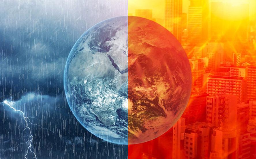
A severe heat wave hit the just-completed 2026 Indian Wells professional tennis tournament in California, with temperatures soaring toward 39 degrees Celsius or 102 Fahrenheit. Players faced stifling conditions, with temperatures exceeding 90F in the shade.
A heat dome in March?
Indian Wells is in the Coachella Valley desert, so heat this time of year isn’t unusual. What is different is the fact that an early heat wave has spread across much of the Western United States.
NBC News reports that Highs above 90 degrees Fahrenheit are expected to be widespread in Southern California, with parts of Arizona and Nevada reaching the triple digits. Some 39 million people in the region are under heat alerts Monday, and the heat wave is likely to expand and intensify as the week goes on.
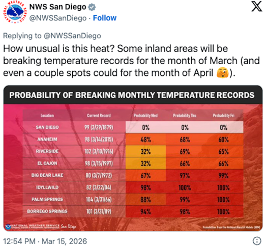
Arizona and Nevada are likely to get temperatures in the triple digits, with new records probably set in San Francisco, Los Angeles, Tucson, Phoenix, Las Vegas, Albuquerque and Denver.
According to the National Weather Service, the “anomalously early” heat wave is caused by a dome of high pressure that build and settles over the West, “baking the region in sweltering conditions.”
Heat domes occur when winds in the upper atmosphere, also known as the jet stream, are influenced by the ocean below. Hot seas cause the winds to shift, resulting in areas of high pressure that trap hot air in place for weeks.
In 2021, a heat dome that settled over western North America killed 619 people in BC alone, mostly seniors stuck in apartments or hotels with no air conditioning. In Lytton, British Columbia, Canada’s hot spot of 49.6C was recorded on June 29, 2021. The next day a wildfire completely destroyed the town.
The Las Vegas office of the National Weather Service wrote on social media Sunday that temperatures will soar to 20+ degrees above normal, making it feel more like early June than mid-March.
CNN reported the extreme heat wave may be comparable in its intensity and rarity to the 2021 Pacific Northwest heat dome, though it will not be as hot. It is, after all, only March. Still, states CNN:
The event is just getting underway. Before it ends later next week, it will have scorched nearly the entire Western part of the country and parts of the Plains states, toppling dozens of daily and monthly temperature records by unusually large margins…
Russ Schumacher, a meteorologist and Colorado’s state climatologist, called the heat dome “astonishing” for its intensity in March. Other meteorologists have described the strength of the heat dome as “genuinely startling” and “mind-boggling” via social media.
El Nino
Looking further out, there are increasing signs of an El Nino weather pattern developing in the months ahead, throwing weather patterns out of whack.
CTV News reports El Niño could affect the Atlantic hurricane season (if the timing is right) and heat the planet even further, making another record warm year much more likely than it otherwise would be either this year or next.
The U.S. National Oceanic and Atmospheric Administration [NOAA] issued an El Niño watch [last] Thursday morning, meaning conditions are favourable for it to develop during the next six months.
The planet was last in El Nino between May 2023 and March 2024. The last Super El Nino occurred in 2015-16 (more on Super El Ninos below).
The winter of 2024 saw record-breaking warmth globally, with Canada experiencing its hottest winter on record and Europe its warmest February and second-warmest winter.
Montreal had its second warmest winter since records began in 1871.
2024 was the hottest year on record globally, corresponding with an El Nino year.
2023 was the worst year for forest fires in Canada. CBC News reported more than 15 million hectares were destroyed by fire across the country, doubling the previous record, 7.6 million ha in 1989.
Wildfires burned 24,900 square kilometers in BC, nearly double the 2018 record of 13,600 square km. That’s an area almost the size of Vancouver Island. Major fires included Donnie Creek, the province’s largest-ever blaze at a staggering 5,800 square km.It’s been well-established that warmer, or colder-than-average ocean temperatures have an influence on weather. According to the National Oceanic and Atmospheric Administration (NOAA), El Nino causes the Pacific jet stream to move south and spread further east. During winter, this leads to wetter conditions than usual in the southern US and warmer and drier conditions in the northern US and Canada.
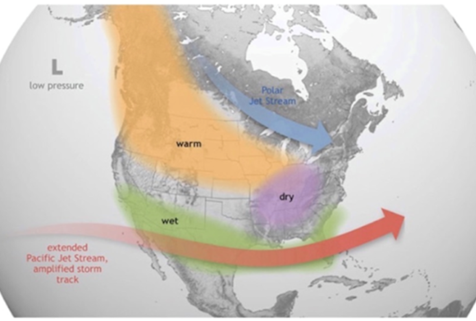
Source: NOAA
El Nino is shorter-lived than La Nina, usually lasting nine months to a year versus a few years for the cooling phenomenon.
However, the second year of an El Nino is often warmer than the first. That’s what happened during the 2015-16 El Nino, which peaked in December and faded in June 2016. The lingering El Nino from January to June made 2016 a record year for warmth.
A Washington Post article states that the abnormal sea surface warmth and storms it brings to the central and eastern Pacific Ocean, leads to drought in other parts of the world including southeast Asia and southern Africa.
Another negative El Nino impact is on coral reefs. A paper in the Journal ‘Science’ warned about the possibility of mass coral bleaching in the Pacific Ocean — similar to what happened in 2016, when the Great Barrier Reef suffered its worst bleaching ever.
A lingering El Nino is likely to mean a drying trend in places accustomed to rainfall and vice versa, with implications for agriculture.
We are currently in the process of transitioning from La Nina to El Nino.
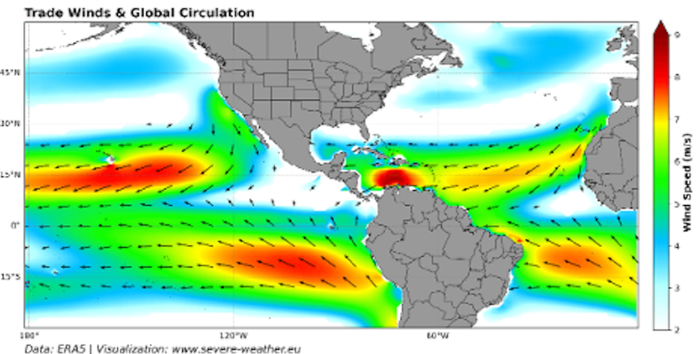
La Nina is what happens when trade winds blow the warm water back into the wester western Pacific and restart the upwelling of cool water towards the surface in the eastern Pacific.
NOAA meteorologists predict El Nino will develop sometime between June and August, and last at least to the end of the year, CTV News states, adding that there is a 1 in 3 chance it will become strong by the winter months, significantly impacting weather in the US.
The presence of El Nino makes it far more likely that 2026 or 2027 will bring the next warmest year on record.
Until early summer, we are likely to experience neutral ocean conditions, where neither La Nina nor El Nino is present.
But that doesn’t mean that the weather will be calm.
BC’s atmospheric river
In British Columbia, an unseasonable atmospheric river is bringing torrential rain to parts of the province, along with rising freezing levels and rapid snowmelt, leading to a risk of floods and avalanches.
The so-called “Pineapple Express” brought warm temperatures and rain from Sunday night through early Tuesday. The Weather Network says It’s unusual to have such a potent atmospheric river, which could rate as an AR3 or AR4 for the immediate coastline, for mid-March. Most of the affairs tend to happen in mid-fall and early winter…
Some areas could see 50 mm to 400 mm of rain while other locales could see up to 100 consecutive hours of rain without a break.
Northern and western Vancouver Island and the Central Coast are under flood watch. Areas expected to receive the most rain include Tofino/western Vancouver Island (200-400mm), the North Shore mountains (150-200+mm) and Squamish (150-200mm).
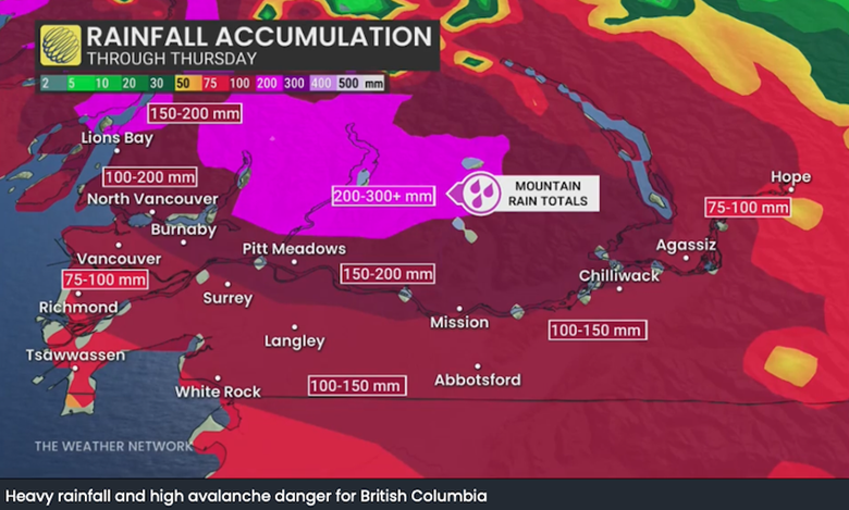
The Pineapple Express, so named because it originates near Hawaii, is expected to continue through much of the week, bringing rising freezing levels to more than 2,000 meters lasting until Friday.
Rain-on-snow runoff are likely at mid-elevations, rapidly increasing flow rates, the Weather Network states.
While there were concerns about a low snowpack earlier in the winter, recent precipitation in the mountains has improved the pack thickness.
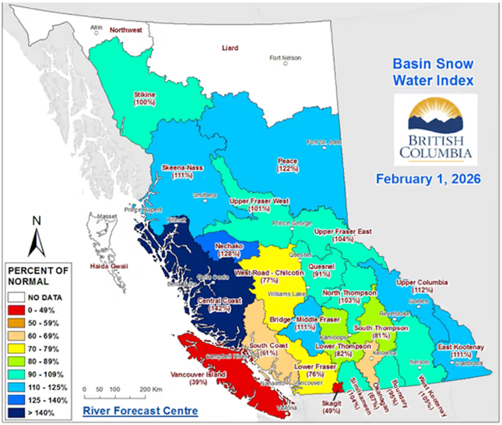
As of early March 2026, British Columbia’s snowpack is near normal, averaging 91% to 105% of the median across various measurements, a significant improvement over the record lows in 2024 and 2025. The provincial snowpack is much higher than last year, though regional variations exist, with some lower-elevation areas having less snow. (AI Overview)
Source: BC River Forecast Centre
As of mid-February, Vancouver Island’s snow pack is the lowest at 69% of normal, followed by the Skagit region at 49% and the South Coast at 61%.
An Okanagan region snowpack level of 62% of normal is raising concerns about water availability. Castanet quoted an Okanagan Basin Water Board member saying that despite the Okanagan being a semi-arid environment, recent conditions suggest it’s becoming drier than normal.
Salmon species that rely on adequate creek levels could be at risk.
How the snow melts is also important. If it melts gradually, watersheds are able to capture more of the runoff. Fast melting, on the other hand, causes water to move through the system too quickly, drying out the landscape, said Sandra Schira.
Linda Parkinson, Metro Vancouver’s water services director of policy planning and analysis, told Daily Hive that Metro Vancouver’s water reservoirs are at their “typical seasonal levels.”
The story ran in mid-February so the snow pack levels reported — 61% of normal for the South Coast and 67% in the Fraser Valley, as of Feb.1 — wouldn’t have captured recent snowfall in the region.
Super El Nino
Some computer models are quite aggressive in developing an El Nino into an intense “Super El Nino” by late fall. If this were to occur, global temperatures would almost certainly spike into record territory.
CTV News explains that the Atlantic hurricane season could be sleepier than usual, since El Niño’s tend to be accompanied by stronger wind shear over the tropical Atlantic Ocean.
Wind shear, which occurs when winds blow at different speeds and/or directions with height, acts as an impediment to fledgling tropical storms and hurricanes.
But an El Nino also tends to strengthen hurricane activity over the central and eastern Pacific Ocean.
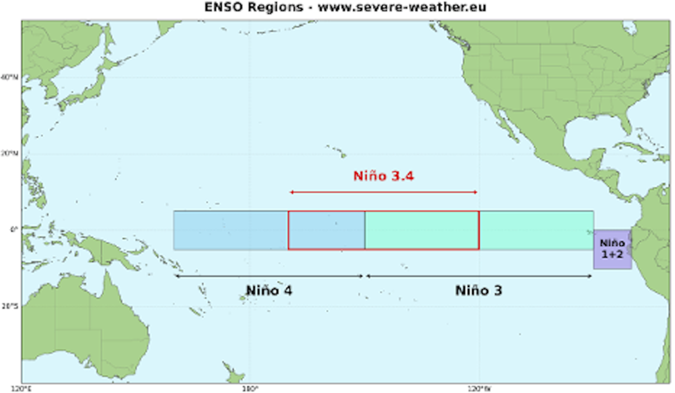
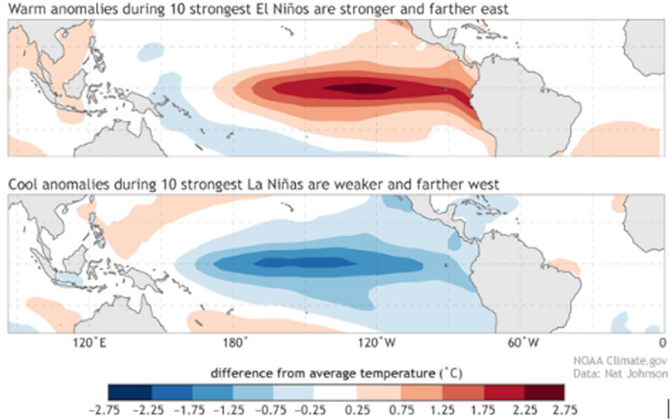
A Super El Niño occurs when sea surface temperatures reach at least 3.6F (2C) above the long-term average. Accuweather’s forecasters estimate that there’s a 15% chance of a Super El Niño developing by the end of the hurricane season in November. (Live Science)
Such an event is driven by powerful westerly wind bursts and a massive ocean Kelviin wave currently surfacing in the eastern Pacific, claims one source:
Such an intense warming of the tropical Pacific can fundamentally alter the global jet stream and trigger a domino effect that extends across North America, Europe, and the rest of the globe.
Source: severe-weather.eu
Source: severe-weather.eu
Source: severe-weather.eu
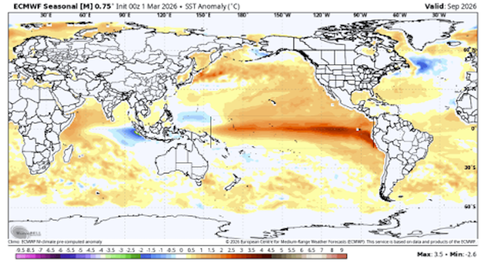
Looking also at the latest NMME multi-model forecast for late summer and fall, you can already see a clear El Niño warm anomaly in the Pacific. This also shows the strength of peak anomalies to reach or exceed the threshold for a Super El Niño event in 2026/2027.
British newspaper The Independent headlined an article with ‘A super El Niño could result in record-setting heat this summer – plus other surprising weather consequences’.
It quotes Washington Post meteorologist Ben Noll: “Changes in location, intensity and frequency of droughts, floods, heat waves and hurricanes are all likely.”
Forecasters at the National Weather Service are already warning of an unusually bad spring storm season across the US South and Midwest. More than 6 million Americans are at risk from thunderstorms and tornadoes.
Noll posted on X that there’s a 22% chance of a Super El Nino by August and an 80% chance of a strong El Nino.
According to the Washington Post, a Super El Nino takes place every 10 to 15 years.
The Independent details the profound effects a Super El Nino would have on US and global weather:
The Inertia interviewed Dr. Patrick Barnard, research director of UC Santa Cruz’s Center for Coastal Climate Resilience, about the potential effects of a ‘Godzilla El Nino’.
In the Q&A, Barnard says that from what he’s seen from the NOAA, there is about a 60% likelihood of a strong El Nino this year.
How could a strong El Nino play out on the West Coast?
“We had El Niños of this magnitude in ’82-83, ’97-98, and 2015-16. That’s what they’re predicting is most likely to happen. We’ve looked at a lot of those winter storm conditions over the last 44 years, and typically, what happens is you get higher water levels along the coast of California, half a foot to a foot higher for the whole winter,” said Barnard. “Storms are going to be right on top of higher sea levels. What’s consistent across all those events is larger wave energy, bigger waves, sometimes 50 percent above average during the winter. That’s the real kicker.”
In other words, great news for surfers.
In California, consistent across previous El Ninos is a high degree of beach erosion and taller waves. The amount of rainfall, however, is inconsistent.
Conclusion
In June of 2021 we thought that it was too early for a heat dome over the Pacific Northwest, including British Columbia. Now in mid-March, BC is getting a late-season atmospheric river, and a heat dome is bringing summerlike temperatures to the Western United States.
Highs above 90 degrees Fahrenheit are expected to be widespread in Southern California, with parts of Arizona and Nevada reaching the triple digits. Some 39 million people in the region were under heat alerts Monday.
Temperatures are expected to soar to 20+ degrees above normal.
Global warming is conspiring with El Nino to bring what is likely to be a record year for heat in 2026 or 2027. The latest record year was 2024. It could even be a Super El Nino, driving global temperatures higher and further disrupting weather patterns on both coasts of North America.
Get ready for extreme heat and its effects on the climate (drought), water supplies, agriculture, food inflation, forests and human health.
Subscribe to AOTH’s free newsletter
Legal Notice / Disclaimer
Ahead of the Herd newsletter, aheadoftheherd.com, hereafter known as AOTH.
Please read the entire Disclaimer carefully before you use this website or read the newsletter. If you do not agree to all the AOTH/Richard Mills Disclaimer, do not access/read this website/newsletter/article, or any of its pages. By reading/using this AOTH/Richard Mills website/newsletter/article, and whether you actually read this Disclaimer, you are deemed to have accepted it.
Divests US$13.5M McEwen Copper Debt to Further Enhance Liquidity ... READ MORE
Aura Minerals Inc. (NASDAQ: AUGO) (B3: AURA33) is pleased to anno... READ MORE
Montero Mining and Exploration Ltd. (TSX-V: MON) (OTC Pink: MXTRF... READ MORE
Barksdale Resources Corp. (TSX-V: BRO) (OTCQB: BRKCF) (FSE: 2NZ) ... READ MORE
Getty Copper Inc. (TSX-V: GTC) (OTCQX: GTCDF) is pleased to an... READ MORE


