








Prospector Metals Corp. (TSX-V: PPP) (OTCQB: PMCOF) (FSE: 1ET) provided a progress update on the fully funded drill program at its ML Project, Yukon. The 2026 field season at ML is now complete and 100 holes were drilled totalling 20,980m. This news release reports results from the TESS Zone, including results from 6 holes. To date, assays from the 2026 program have been received and released for 16 holes and 84 holes are awaiting assay results.
Prospector has posted a pre-recorded webinar hosted by CEO Rob Carpenter and VP Exploration Jodie Gibson, where they discuss the results from today’s release. Click on the following:
Cannot view this video? Visit:
https://www.youtube.com/watch?v=fhhywwZdeJU
Dr. Rob Carpenter, Ph.D., P.Geo., Co-Chairman, President and CEO of Prospector, commented: “The TESS structural corridor has now been traced for at least 400m and high-grade gold mineralization is now drill confirmed over at least 100m within it. Our exploration strategy continues to be anchored by an appreciation for structural control and new 3D interpretations at TESS strongly suggest the presence of multiple, stacked, high-grade plunging zones occurring within a dynamic fault zone. We believe this setting resembles structurally controlled gold systems more typically observed in metamorphic terranes such as the Canadian Shield, where plunging shoots also control the location of high-grade gold.”
New TESS Drill Results
Hole ML26-56 yielded a high-grade zone of: 41.34 g/t Au over 7.81m (from 100.62m) including: 130.77 g/t Au over 2.25m (from 105.54m) and 194.23 g/t Au over 1.03m (from 106.76m).
Hole ML26-54 yielded 6.10 g/t Au, 10.76 g/t Ag and 0.55% Cu over 5.79m (from 64.31m) including 1.95m of 15.15 g/t Au, 24.89 g/t Ag and 1.22% Cu (from 64.31m).
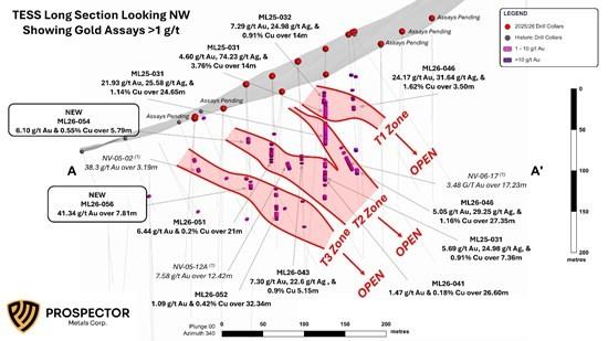
Figure 1: Long-Section of the TESS showing SE plunging high-grade shoots T1, T2, & T3 with Gold Assays > 1g/t Au.
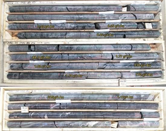
Figure 2: Core Photos of Mineralized Zone in ML26-056
Project Update / Summary
2026 ML Drill Program
A total of 100 holes for 20,980 meters were drilled on the ML Project in 2026 testing nine target areas including TESS, Pebble, NIT, Rubble North, Phoenix, Bueno, ML North, Camp Valley, and Lorrie targets. To date results have been received on 16 holes on the TESS target and adjacent areas. Individual results for samples discussed in this release range from trace to 215.1 g/t Au, to 38.40 g/t Ag, and to 1.94% Cu.
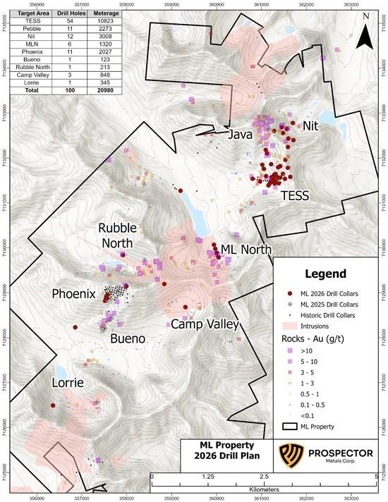
Figure 3: ML Property Target Areas and Drilling to Date
TESS Drilling
A total of 10,823m of drilling over 54 holes were completed on the TESS zone. This includes drilling focused on systematic step-out drilling on the TESS-North Vein mineralized horizon and wider step-out drilling to evaluate structural extensions to the NE and SW of the TESS mineralized zone. Assay results have been received on an additional 6 drill holes and are discussed below. Estimated true thickness of the reported intervals ranges from 60 – 70% of the drilled interval.
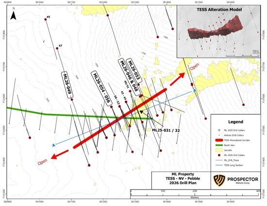
Figure 4: TESS-North Vein Plan Map
ML26-054, -055, & -056
Holes ML26-054 – 056 were drilled on a fence as a 25m step-out to previously announced holes ML26-050 – 052 and are 100m to the southwest of ML26-046. The holes were drilled at a 160o azimuth and dips of -50, -60, and -65, respectively.
ML26-054 was drilled at a -50 dip and intersected the TESS alteration zone from 60 – 70m downhole, returning 5.79m of 6.10 g/t Au, 10.76 g/t Ag, & 0.55% Cu from 64.31m depth; including 1.95m of 15.15 g/t Au, 24.89 g/t Ag, & 1.22% Cu from 64.31m.
ML26-055 was drilled at a -60 dip and intersected the TESS alteration zone from 61 – 102m but only returned anomalous results of 20.36m of 0.34 g/t Au from 84.83m; including 1.94m of 1.86 g/t Au from 100.22m.
ML26-056 was drilled at a -65 dip and intersected the TESS alteration zone from 89 – 108m, returning 7.81m of 41.34 g/t Au from 100.62m depth; including 130.77 g/t Au over 2.25m from 105.54m.
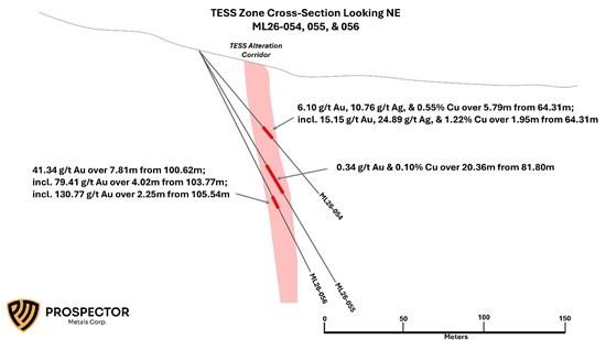
Figure 5: Cross-Section Looking NE showing drill holes ML26-054, -055, & -056
ML26-048 & 53
Holes ML26-048 and -053 were drilled on a fence above and below previously announced hole ML26-046. ML26-048 was drilled from the same drill pad as ML26-046 at a 160o azimuth and -50 dip, and ML26-053 was drilled from a drill pad 40m upslope of ML26-046 at a 160o azimuth and -60 dip and was designed as a 25m down dip step-out to ML26-046. Similar to ML26-046, both holes intersected broad zones of pervasive quartz-sericite-clay alteration, but with significantly lower sulfide mineralization, and only returned anomalous results with the best intercept of 1.1m of 2.89 g/t Au, 37.90 g/t Ag, & 1.58% Cu from 52.95m depth in ML26-048.
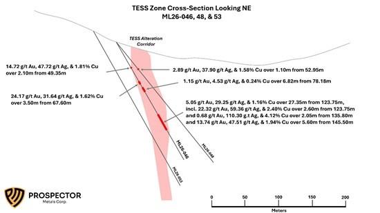
Figure 6: Cross-Section Looking NE showing drill holes ML26-046, -048, & -053
ML26-049
Hole ML26-049 was drilled 130m west of ML26-054 – 056 on the same fence as previously announced holes ML26-045 and -047. The hole was targeting a subvertical resistivity break noted on a historic IP geophysics line across the area. The hole hit TESS style alteration and sulfide mineralization from 92 – 106m, but only returned anomalous results for gold and copper including 8.3m of 0.18 g/t Au and 0.11% Cu from 95.85m depth.
TESS Discussion
Drilling in 2026 has successfully defined the TESS Zone over at least 400m along trend and to 175m depth. Mineralization is hosted in a tabular, northeast trending and steep south dipping structural corridor which appears to have a true thickness ranging from 15-25m. Within this envelope, an “hourglass” shaped high-grade plunging core has now been assay confirmed in at least 1 hole on every drill section over 100m (section spacing of 25m), and there are indications for multiple plunging high-grade shoots. Mineralization on TESS is associated with calc-silicate alteration and/or quartz-sericite-clay alteration of conglomerate, grits, and lamprophyre – diorite dikes with disseminated to fracture-vein controlled sulfide mineralization consisting of pyrrhotite/pyrite, arsenopyrite, chalcopyrite, bismuth-tellurium minerals, and, locally, visible gold. The alteration and mineralization are focused along a northeast trending, steeply south dipping, structural corridor, with the highest-grade mineralization occurring where the structural zone intersects favorable lithologic units, forming plunging shoots. One of these favorable units is an east-southeast trending zone of calc-silicate altered calcareous conglomerate historically known as the “North Vein.” Where the North Vein lithology is cut by TESS structures an early pyroxene dominated calc-silicate assemblage is overprinted by an actinolite-quartz-carbonate alteration assemblage with quartz-carbonate veining; overprint and/or remobilization of early sulfide minerals; and Bi-Te-Au mineralization. The TESS corridor is open along trend in both directions and to depth. Drilling has also been conducted along the western projection of the North Vein horizon where it is intersected by other NE trending structural zones based on geological mapping and prospecting.
Table 1: 2026 Drill Results Reported to Date
| Hole ID | From (m) | To (m) | Interval (m) | Au (g/t) | Ag (g/t) | Cu (%) |
| ML26-040 | No Significant Values | |||||
| ML26-041 | 135.31 | 161.94 | 26.60 | 1.47 | 3.35 | 0.18 |
| And | 166.44 | 167.44 | 1.00 | 2.30 | 12.30 | 0.56 |
| And | 181.82 | 183.12 | 1.30 | 1.78 | 44.10 | 1.90 |
| ML26-043 | 101.30 | 106.45 | 5.15 | 7.30 | 22.26 | 0.90 |
| Incl | 101.30 | 102.61 | 1.30 | 25.60 | 75.90 | 2.88 |
| And | 109.59 | 110.09 | 0.50 | 19.50 | – | – |
| Within | 101.30 | 119.36 | 18.06 | 2.73 | 6.92 | 0.28 |
| And | 149.08 | 150.93 | 1.85 | 1.07 | 21.64 | 1.02 |
| ML26-044 | 168.39 | 169.54 | 1.15 | 3.28 | – | – |
| ML26-045 | 89.72 | 92.30 | 2.58 | 1.65 | – | – |
| ML26-046 | 43.35 | 45.45 | 2.10 | 14.72 | 47.72 | 1.81 |
| And | 67.60 | 71.10 | 3.50 | 24.17 | 31.64 | 1.62 |
| And | 78.18 | 85.00 | 6.82 | 1.15 | 4.53 | 0.24 |
| And | 123.75 | 151.10 | 27.35 | 5.05 | 29.25 | 1.16 |
| Incl | 123.75 | 126.35 | 2.60 | 22.32 | 59.36 | 2.40 |
| And | 135.80 | 137.85 | 2.05 | 0.68 | 110.30 | 4.12 |
| And | 145.50 | 151.10 | 5.60 | 13.74 | 47.51 | 1.94 |
| ML26-047 | No Significant Values | |||||
| ML26-048 | 52.95 | 54.05 | 1.10 | 2.89 | 37.90 | 1.58 |
| ML26-049 | 95.85 | 104.15 | 8.30 | 0.18 | – | 0.11 |
| ML26-050 | 69.65 | 71.35 | 1.70 | 4.30 | 1.80 | 0.14 |
| ML26-051 | 73.70 | 94.70 | 21.00 | 6.44 | 4.43 | 0.20 |
| Incl | 73.70 | 75.50 | 1.80 | 56.48 | – | – |
| And | 91.25 | 91.75 | 0.50 | 43.20 | – | – |
| ML26-052 | 115.20 | 147.54 | 32.34 | 1.09 | 8.45 | 0.42 |
| Incl | 120.61 | 123.44 | 2.83 | 3.38 | 63.32 | 3.32 |
| And | 139.90 | 145.36 | 5.46 | 2.88 | 8.33 | 0.35 |
| ML26-053 | No Significant Values | |||||
| ML26-054 | 64.31 | 70.10 | 5.79 | 6.10 | 10.76 | 0.55 |
| Incl | 64.31 | 66.26 | 1.95 | 15.15 | 24.89 | 1.22 |
| ML26-055 | 81.80 | 102.16 | 20.36 | 0.34 | – | 0.10 |
| Incl | 100.22 | 102.16 | 1.94 | 1.86 | – | 0.18 |
| ML26-056 | 100.62 | 108.43 | 7.81 | 41.34 | – | – |
| Incl | 103.77 | 107.79 | 4.02 | 79.41 | – | – |
| Incl | 105.54 | 107.74 | 2.25 | 130.77 | – | – |
Table 2: Drill Collar Information for Holes in this Release
| Hole ID | Easting | Northing | Elevation | Azimuth | Dip | Depth (m) |
| ML26-048 | 361319 | 7131609 | 1662 | 155 | -50 | 233.17 |
| ML26-049 | 361102 | 7131597 | 1575 | 160 | -50 | 277.37 |
| ML26-053 | 361311 | 7131643 | 1678 | 160 | -60 | 268.22 |
| ML26-054 | 361226 | 7131574 | 1613 | 160 | -50 | 115.82 |
| ML26-055 | 361226 | 7131574 | 1613 | 160 | -60 | 166.12 |
| ML26-056 | 361226 | 7131574 | 1613 | 160 | -65 | 152.40 |
(1) Historical exploration drill core data and composite assay intervals for NV-05-02, NV-05-12A, and NV-06-17 in Figure 1 are sourced from the Mike Lake Property Assessment Report Dawson Mining District, Yukon Territory. Document compiled by Archer, Cathro & Associates (1981) Limited on behalf of Dynamite Resources Ltd., dated March 2008. Filed with the Yukon Geological Survey Assessment Report Archive (Report #095029). Historical intervals reflect continuous down-hole core lengths; true widths of mineralization have not been determined from the historical data. The QP has verified the historical data disclosed in this release by reviewing the original drill logs and assay certificates, and by conducting confirmation drilling adjacent to the historical 2005-2006 Dynamite Resources drill holes. The new drilling successfully confirmed the geological continuity and high-grade nature of the historical mineralization, thereby verifying the historical database for the purposes of this disclosure.
Assay Methodology & QA/QC
The analytical work on the 2026 ML Project is being performed by Bureau Veritas (“BV”) Labs, an internationally recognized analytical services provider. All samples are submitted to BV’s prep facility located in Whitehorse, YT. Once prepared the samples are shipped to BV’s Vancouver, BC facility for analysis. All rock samples are prepared using procedure PRP70-250 (Dry, crush to 70% passing 2mm, riffle split off 250g, pulverize split to better than 85% passing 75 microns) and analyzed by method FA430 (30g fire assay with AAS finish) and MA200 (multi-element analysis with 4-acid digest and ICP-MS finish). Samples containing >10g/t Au are reanalyzed using a 50g Fire Assay with a Gravimetric finish. Samples containing >100 ppm Ag and/or >1% Cu, Pb, & Zn are reanalyzed using a 4-acid digest and ore grade ICP-ES analysis. All soil samples are prepared using procedure SS80 (Dry and sieve to -80 mesh) and analyzed by method AQ201 (15g multi-element analysis with aqua-regia digest and ICP ES/MS finish).
The work is being completed using industry standard procedures, including a quality assurance/quality control program consisting of the insertion of certified standards, blanks, and duplicates into the sample stream.
Qualified Person
The technical content disclosed in this press release was reviewed and approved by Jodie Gibson, P.Geo., Vice President Exploration of Prospector, and a Qualified Person as defined under National Instrument 43-101.
About Prospector Metals Corp.
Prospector Metals Corp. is a proud member of Discovery Group and focuses on district scale, early-stage exploration of gold and base metal prospects. The Company creates shareholder value through new discoveries and identifies underexplored or overlooked mineral districts displaying important structural and mineralogical occurrences similar to more established mining operations. Prospector is currently concentrating its efforts on its ML Project in the Yukon where it has discovered a high-grade gold-copper-silver zone (see news release dated October 1, 2025). Prospector establishes and maintains relationships with local and Indigenous rightsholders and seeks to develop partnerships and agreements that are mutually beneficial to all interested parties.
1911 Gold Corporation (TSX-V: AUMB) (OTCQX: AUMBF) (FRA: 2KY) is pleased... READ MORE
Prince Silver Corp. (CSE: PRNC) (OTCQX: PRNCF) (FSE: T130) is ple... READ MORE
Sun Summit Minerals Corp. (TSX-V: SMN) (OTCQB: SMREF) is please... READ MORE
Maiden Drilling at Lynx Expands Scale of Project Including 420 Me... READ MORE


