








Pirate Gold Corp. (TSX-V: YARR) (OTCQB: YARRF) is pleased to report assay results from drilling at the Moby Dick copper-gold discovery and the Western EM anomaly within the Crippleback Intrusive Suite at its 100%-owned Treasure Island Project in Central Newfoundland. The Treasure Island Project covers over 90 km of strike along the Valentine Lake Fault Zone in Canada’s newest gold district.
Moby Dick Drilling
PGC-26-118 was collared approximately 100m west of discovery holes PGC-26-058 and PGC-26-068 and drilled parallel to them. Beginning at the bedrock interface at 12.6m, the hole intersected 0.24% Cu Eq (0.13% Cu; 0.087 g/t Au; 1.72 g/t Ag) over 299.4m to 312.0m. This interval includes 0.43% Cu Eq (0.21% Cu; 0.184 g/t Au; 2.00 g/t Ag) over 56.5m, including 0.52% Cu Eq (0.24% Cu; 0.238 g/t Au; 2.06 g/t Ag) over 35.6m, and a separate interval of 0.43% Cu Eq (0.26% Cu; 0.112 g/t Au; 4.12 g/t Ag) over 19.8m. The hole obliquely intersected a late-stage mafic dyke from 334.0m to 423.0m before re-entering the mineralized zone. From 424.0m to 496.7m, PGC-26-118 returned 0.23% Cu Eq (0.12% Cu; 0.084 g/t Au; 1.65 g/t Ag) over 72.7m, including 0.33% Cu Eq (0.17% Cu; 0.121 g/t Au; 2.32 g/t Ag) over 37.0m.
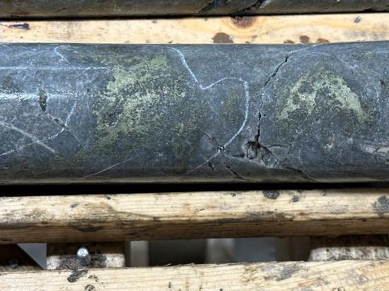
Figure 1. Chalcopyrite mineralization in PGC-26-118 at approximately 294.9m.*
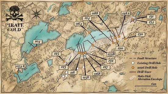
Figure 2. Recent drilling at Moby Dick and the Western EM anomaly.
“With copper-gold mineralization encountered from the bedrock surface to nearly 500 metres downhole in PGC-26-118, we are beginning to see the scale taking shape at Moby Dick. The broad mineralized envelope in this hole, alongside the higher-grade core encountered in PGC-26-068, is an encouraging result that adds to our confidence in the size and continuity of the system.
“The additional drilling is giving us a much clearer understanding of the orientation of this large zone and indicates that the core of the Moby Dick EM anomaly continues beneath Crippleback Lake. The arrival of the barge drill is an important next step, allowing us to test this highly prospective area for the first time. At the same time, the Mobile MT survey will help us see deeper into the system, refine our geological model and identify the strongest targets for continued drilling.
“We are also encouraged by the first hole into the Western EM anomaly, which displays a geophysical signature similar to Moby Dick. The hole returned a broad anomalous copper-gold interval with several narrow higher-grade zones, confirming that this target warrants additional work. With new access established from the south, we will be able to approach the anomaly from a better direction and more effectively test what we believe could be another significant target within the broader Crippleback system,” said Greg Matheson, VP Exploration.
“Each round of drilling is making Moby Dick more compelling. Broad copper-gold mineralization has now been intersected in three holes, yet most of the four-kilometre alteration system remains untested. With assays pending, barge drilling preparing to test beneath Crippleback Lake and Mobile MT underway, we have multiple opportunities to expand the mineralized footprint and target what we believe could be the stronger parts of this large system,” said Denis Laviolette, Executive Chairman and CEO.
Additional Moby Dick Results
PGC-26-088 was drilled approximately 1,800m east of PGC-26-118 at the southeastern end of the Moby Dick alteration anomaly. The hole encountered broad argillic clay alteration from the bedrock interface at 28.5m to 398.0m, where drilling ended due to swelling clay. No visible copper mineralization was noted, although pyrite occurred throughout the hole. Near the bedrock surface, PGC-26-088 intersected 0.18% Cu Eq (0.08% Cu; 0.04 g/t Au; 4.70 g/t Ag) over 20.0m, overlapping an interval of 1.26% Zn over 21.6m. Additional copper mineralization from 164.9m to 177.0m returned 0.12% Cu Eq (0.09% Cu; 0.024 g/t Au; 0.77 g/t Ag) over 12.1m. From 241.9m to 277.3m, the hole returned 0.11% Cu Eq (0.06% Cu; 0.026 g/t Au; 1.80 g/t Ag) over 35.4m. This interval coincides with zinc mineralization from 240.9m to 251.0m, which returned 0.52% Zn over 10.1m. The relationship between the copper-gold and zinc mineralization remains unclear, and zinc is not included in the reported copper-equivalent grades.
Western EM Anomaly Drilling
The Western EM anomaly is a low-resistivity zone identified by the 2026 airborne EM survey approximately 2.5 kilometres west of the Moby Dick resistivity anomaly (Figure 4).
PGC-26-074A encountered unaltered gabbro with a broad anomalous copper-gold interval from the bedrock surface at 17.0m to 338.2m downhole, returning 0.07% Cu Eq (0.05% Cu; 0.01 g/t Au; 0.96 g/t Ag) over 321.2m. Narrow higher-grade intervals include 0.86% Cu Eq (0.56% Cu; 0.154 g/t Au; 12.5 g/t Ag) over 1.0m from 23.0m to 24.0m; 0.84% Cu Eq (0.74% Cu; 0.019 g/t Au; 7.55 g/t Ag) over 0.7m from 195.0m to 195.7m; and 0.92% Cu Eq (0.44% Cu; 0.316 g/t Au; 12.5 g/t Ag) over 0.7m from 336.6m to 337.3m. The hole also returned 0.11% Cu Eq (0.08% Cu; 0.02 g/t Au; 1.48 g/t Ag) over 24.0m from 246.0m to 270.0m. PGC-26-074A is the only hole to have tested the Western EM anomaly and did not adequately explain the EM response. Follow-up drilling is being planned from the southern side of the anomaly.
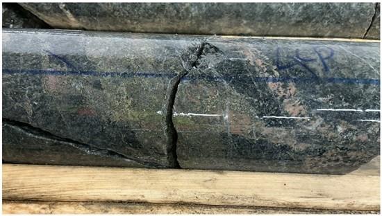
Figure 3. Chalcopyrite mineralization in PGC-26-074A at the Western EM anomaly at approximately 195.2m.*
*Core photographs in Figures 1 and 3 are selective and are not representative of the entire mineralized intervals reported for PGC-26-118 and PGC-26-074A.
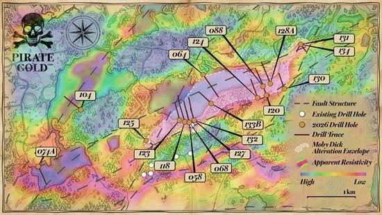
Figure 4. Recent drilling at Moby Dick and the Western EM anomaly over airborne EM resistivity.
| Drill Hole | From (m) | To (m) | Length (m) | Cu (%) | Au (g/t) | Ag (g/t) | Cu Eq (%) | Au Eq (g/t) | Zn (%) | ||||||||||||||||||||||
| PGC-26-074A | 17.0 | 338.2 | 321.2 | 0.05 | 0.01 | 0.96 | 0.07 | 0.06 | – | ||||||||||||||||||||||
| Incl. | 23.0 | 24.0 | 1.0 | 0.56 | 0.154 | 12.5 | 0. | .79 | – | ||||||||||||||||||||||
| Incl. | 195.0 | 195.7 | 0.7 | 0.74 | 0.019 | 7.55 | 0.84 | 0.77 | – | ||||||||||||||||||||||
| Incl. | 246.0 | 270.0 | 24.0 | 0.08 | 0.02 | 1.48 | 0.11 | 0.10 | – | ||||||||||||||||||||||
| Incl. | 336.6 | 337.3 | 0.7 | 0.44 | 0.316 | 12.5 | 0.92 | 0.84 | – | ||||||||||||||||||||||
| PGC-26-088 | 32.0 | 52.0 | 20.0 | 0.08 | 0.04 | 4.70 | 0.18 | 0.16 | – | ||||||||||||||||||||||
| With | 30.4 | 52.0 | 21.6 | – | – | – | – | – | 1.26 | ||||||||||||||||||||||
| And | 164.9 | 177.0 | 12.1 | 0.09 | 0.024 | 0.77 | 0. | .11 | – | ||||||||||||||||||||||
| And | 241.9 | 277.3 | 35.4 | 0.06 | 0.026 | 1.80 | 0.11 | 0.10 | – | ||||||||||||||||||||||
| With | 240.9 | 251.0 | 10.1 | – | – | – | – | – | 0.52 | ||||||||||||||||||||||
| PGC-26-104 | NSR | NSR | NSR | NSR | NSR | NSR | NSR | NSR | |||||||||||||||||||||||
| PGC-26-118 | 12.6 | 312.0 | 299.4 | 0.13 | 0.087 | 1.72 | 0.24 | 0.22 | – | ||||||||||||||||||||||
| Incl. | 149.0 | 205.5 | 56.5 | 0. | .184 | 2.00 | 0.43 | 0.39 | – | ||||||||||||||||||||||
| Incl. | 157.0 | 192.6 | 35.6 | 0.24 | 0.238 | 2.06 | 0.52 | 0.47 | – | ||||||||||||||||||||||
| And incl. | 292.2 | 312.0 | 19.8 | 0.26 | 0.112 | 4.12 | 0.43 | 0.39 | – | ||||||||||||||||||||||
| And | 312.0 | 337.7 | 25.7 | 0.05 | 0.047 | 1.02 | 0.11 | 0.10 | – | ||||||||||||||||||||||
| And | 377.4 | 385.4 | 8.00 | 0.07 | 0.054 | 0.57 | 0.13 | 0.12 | – | ||||||||||||||||||||||
| And | 424.0 | 496.7 | 72.7 | 0.12 | 0.084 | 1.65 | 0.23 | 0.21 | – | ||||||||||||||||||||||
| Incl | 424.0 | 461.0 | 37.0 | 0.17 | 0.121 | 2.32 | 0.33 | 0.30 | – |
Table 1. Significant assay results.
Target zones: PGC-26-074A, Western EM anomaly; PGC-26-088, Moby Dick East; PGC-26-104, regional target; PGC-26-118, Moby Dick.
1 True widths are unknown; all intervals are reported as downhole lengths.
2 See the QA/QC section for metal-equivalent assumptions and calculation methodology.
3 Intervals not listed are considered to have returned no significant assay results.
Moby Dick Alteration Zone
Hosted within the Crippleback Intrusive Suite in the southern portion of the Treasure Island Project (Figure 5), Moby Dick is a large advanced argillic alteration zone first identified in 2024. Drilling has now traced the alteration over approximately 4,000m of strike, up to 850m in width and to a depth of 500m. Its full extent remains unknown and is constrained only by drilling completed to date. Spectral analysis indicates that the advanced argillic alteration is primarily composed of montmorillonite, kaolinite and pyrophyllite.
As shown in Figure 4, the modelled Moby Dick alteration zone closely correlates with a low-resistivity electromagnetic (“EM”) signature.
Initial results from the grassroots discovery were reported on June 17, 2026 and showed broad copper-gold mineralization consistent with a copper-gold porphyry/high-sulphidation epithermal mineralizing system. Discovery hole PGC-26-058 returned 0.38% Cu Eq (0.12% Cu; 0.22 g/t Au; 1.76 g/t Ag) over 112.4m. PGC-26-068 returned 0.54% Cu Eq (0.13% Cu; 0.36 g/t Au; 1.73 g/t Ag) over 180.8m, including 1.48% Cu Eq (0.28% Cu; 1.07 g/t Au; 3.42 g/t Ag) over 49.4m.
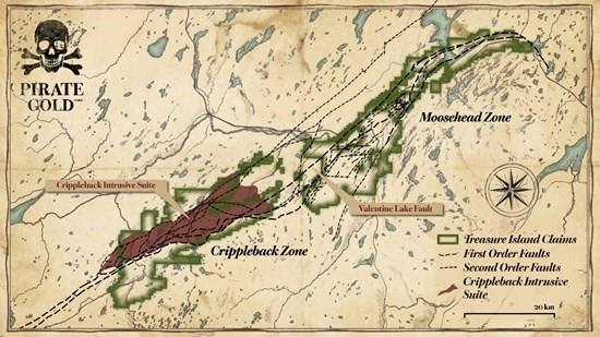
Figure 5. Location of Crippleback within the Treasure Island Project.
Moby Dick Interpretation and Next Steps
As an early-stage grassroots discovery with few direct local analogues, Moby Dick is undergoing continued technical investigation to better understand its geological setting, geometry and distribution of mineralization.
Drilling to date has outlined broad copper-gold mineralization in three holes across approximately 100m of strike and to vertical depths of approximately 340m within an expansive advanced argillic alteration zone. In most cases, copper-gold mineralization has been confined to the alteration envelopes.
Three mineralization styles have been observed to date. The first consists of broad intervals containing intermittent disseminated chalcopyrite and elevated pyrite, together with fine chalcopyrite-filled fractures and locally more massive chalcopyrite over several centimetres of downhole width. The second occurs in strongly altered quartz monzonite and gabbroic intrusions containing disseminated to locally massive pyrite without visually discernible copper sulphides. The third is associated with elevated magnetite concentrations containing chalcopyrite and pyrite within granodiorite and quartz monzonite intrusions and is interpreted to be magmatic in origin. Detailed mineralogical studies are underway to further assess and categorize these styles.
The magnetite-chalcopyrite mineralization occurs within a traceable copper-gold core zone encountered in PGC-26-058, PGC-26-068 and PGC-26-118. This zone correlates with the central low-resistivity portion of the Moby Dick EM anomaly and is interpreted to continue beneath Crippleback Lake. The Company has contracted a barge-mounted drill to begin testing portions of the anomaly beneath Crippleback Lake in September 2026.
Airborne Mobile MT Survey
The Company has contracted Expert Geophysics of Newmarket, Ontario, to conduct an airborne Mobile MT geophysical survey over the southern portion of the Treasure Island Project. The survey follows the airborne EM program completed in early 2026, which defined a resistivity anomaly closely correlated with the Moby Dick alteration zone (Figure 4). Mobile MT is a passive EM system used to map subsurface resistivity and identify potential deeper targets associated with copper-gold porphyry and epithermal mineralization. The survey is planned to cover 4,345 line-kilometres at 100m line spacing and image subsurface resistivity to an approximate depth of 1 to 2 kilometres. The survey commenced on August 30, 2026, and is expected to take four to five weeks, with final deliverables expected approximately eight weeks after completion.
Visual Observations from Follow-up Drilling at Moby Dick
Eleven additional holes have targeted the Moby Dick alteration zone relative to discovery holes PGC-26-058 and PGC-26-068 (Figures 2 and 4). PGC-26-123 was completed approximately 200m west; PGC-26-125, 1,000m southwest; PGC-26-127 and PGC-26-132, approximately 100m east; PGC-26-133B, 500m east; PGC-26-124, 1,500m east; PGC-26-120, 1,700m east; PGC-26-128A, 1,850m east; and PGC-26-130, 2,100m east. PGC-26-131 and PGC-26-134 were drilled approximately 2,800m east of the discovery holes at the eastern end of the Moby Dick EM anomaly. The intervals of logged visible copper mineralization are summarized below.
| Hole ID | From (m) | To (m) | Description |
| PGC-26-120 | 43.7 | 73.2 | Fine grained chalcopyrite disseminated in host rock |
| PGC-26-120 | 124.0 | 215.6 | Fine grained chalcopyrite disseminated in host rock |
| PGC-26-120 | 223.6 | 224.0 | Fine grained chalcopyrite stringers |
| PGC-26-120 | 236.1 | 249.5 | Fine grained disseminated chalcopyrite blebs or stringer |
| PGC-26-120 | 313.6 | 314.0 | Fine grained chalcopyrite disseminated in host rock |
| PGC-26-120 | 322.0 | 322.5 | Fine grained chalcopyrite disseminated in vein and host rock |
| PGC-26-120 | 326.8 | 329.0 | Fine grained chalcopyrite disseminated in host rock |
| PGC-26-120 | 357.5 | 367.1 | Fine grained chalcopyrite disseminated in host rock |
| PGC-26-120 | 395.9 | 401.0 | Fine grained chalcopyrite disseminated in host rock |
| PGC-26-120 | 430.3 | 445.1 | Fine grained chalcopyrite disseminated in host rock |
| PGC-26-120 | 477.6 | 478.0 | Fine grained chalcopyrite disseminated in vein and host rock |
| PGC-26-123 | 32.0 | 32.5 | Medium grained chalcopyrite in vein fill |
| PGC-26-123 | 70.0 | 368.4 | Fine grained chalcopyrite disseminated in host rock |
| PGC-26-124 | 50.5 | 54.8 | Medium grained chalcopyrite stringer in host rock |
| PGC-26-124 | 101.0 | 102.0 | Fine grained chalcopyrite stringer in host rock |
| PGC-26-124 | 114.0 | 115.0 | Fine grained chalcopyrite disseminated in host rock |
| PGC-26-124 | 124.3 | 125.3 | Fine grained chalcopyrite disseminated in host rock |
| PGC-26-124 | 141.0 | 142.0 | Fine grained chalcopyrite disseminated in host rock |
| PGC-26-124 | 158.8 | 159.7 | Fine grained chalcopyrite stringer in vein and host rock |
| PGC-26-124 | 237.0 | 263.2 | Fine grained chalcopyrite blebs in host rock |
| PGC-26-124 | 340.0 | 353.8 | Fine grained chalcopyrite blebs in vein |
| PGC-26-124 | 433.0 | 436.0 | Medium grained chalcopyrite blebs in host rock |
| PGC-26-125 | 60.0 | 61.0 | Fine grained chalcopyrite disseminated in host rock |
| PGC-26-125 | 65.0 | 67.0 | Fine grained chalcopyrite disseminated in host rock |
| PGC-26-125 | 70.0 | 71.0 | Fine grained chalcopyrite disseminated in vein and host rock |
| PGC-26-125 | 84.0 | 85.0 | Fine grained chalcopyrite in vein |
| PGC-26-125 | 88.0 | 89.0 | Fine grained chalcopyrite in vein |
| PGC-26-125 | 130.0 | 131.0 | Fine grained chalcopyrite disseminated in host rock |
| PGC-26-125 | 146.0 | 147.0 | Fine grained chalcopyrite disseminated in host rock |
| PGC-26-125 | 272.0 | 273.0 | Fine grained chalcopyrite blebs in veins |
| PGC-26-125 | 292.0 | 293.0 | Fine grained chalcopyrite blebs in veins |
| PGC-26-127 | 149.0 | 150.0 | Fine grained chalcopyrite blebs in host rock |
| PGC-26-127 | 319.0 | 320.0 | Fine grained chalcopyrite blebs in host rock |
| PGC-26-127 | 387.0 | 395.0 | Medium grained chalcopyrite in host rock |
| PGC-26-127 | 415.0 | 416.0 | Fine grained chalcopyrite disseminated in host rock |
| PGC-26-127 | 422.0 | 487.0 | Fine grained chalcopyrite disseminated in host rock |
| PGC-26-127 | 500.0 | 508.0 | Fine grained chalcopyrite disseminated in host rock |
| PGC-26-127 | 513.0 | 562.0 | Fine grained chalcopyrite disseminated in host rock |
| PGC-26-127 | 605.0 | 635.0 | Fine grained chalcopyrite disseminated in vein and host rock |
| PGC-26-127 | 639.0 | 640.0 | Fine grained chalcopyrite as band in vein and host rock |
| PGC-26-127 | 643.0 | 644.0 | Fine grained chalcopyrite disseminated in host rock |
| PGC-26-127 | 662.0 | 666.0 | Fine grained chalcopyrite disseminated in vein and host rock |
| PGC-26-128A | 22.0 | 22.4 | Fine grained chalcopyrite blebs in host rock |
| PGC-26-128A | 27.5 | 29.0 | Fine grained chalcopyrite blebs in host rock |
| PGC-26-128A | 35.7 | 35.8 | Fine grained chalcopyrite blebs in veins |
| PGC-26-128A | 179.7 | 179.8 | Fine grained chalcopyrite blebs in vein and host rock |
| PGC-26-128A | 188.3 | 188.5 | Fine grained chalcopyrite blebs in vein and host rock |
| PGC-26-128A | 219.2 | 219.3 | Fine grained chalcopyrite blebs in vein and host rock |
| PGC-26-128A | 274.6 | 278.8 | Fine grained chalcopyrite blebs in veins |
| PGC-26-128A | 328.3 | 328.8 | Fine grained chalcopyrite disseminated in host rock |
| PGC-26-128A | 351.0 | 352.0 | Coarse grained chalcopyrite blebs in host rock |
| PGC-26-128A | 396.0 | 397.0 | Coarse grained chalcopyrite blebs in vein |
| PGC-26-128A | 407.0 | 408.0 | Fine grained chalcopyrite disseminated in host rock |
| PGC-26-130 | No notable visible copper mineralization | ||
| PGC-26-131 | No notable visible copper mineralization | ||
| PGC-26-132 | 17.0 | 18.5 | Fine grained chalcopyrite disseminated in host rock |
| PGC-26-132 | 241.0 | 242.0 | Fine grained chalcopyrite disseminated in host rock |
| PGC-26-132 | 249.0 | 250.0 | Semi massive chalcopyrite in host rock |
| PGC-26-132 | 317.0 | 330.0 | Fine grained chalcopyrite blebs in host rock |
| PGC-26-132 | 560.0 | 561.0 | Fine grained chalcopyrite disseminated in host rock |
| PGC-26-133B | 379.5 | 381.1 | Fine grained chalcopyrite disseminated in host rock |
| PGC-26-133B | 423.7 | 427.0 | Fine grained chalcopyrite disseminated in host rock |
| PGC-26-133B | 437.0 | 438.0 | Fine grained chalcopyrite disseminated in host rock |
| PGC-26-133B | 442.0 | 447.0 | Fine grained chalcopyrite disseminated in host rock |
| PGC-26-134 | No notable visible copper mineralization |
Table 2. Visual mineralization observations from follow-up drilling at Moby Dick.
The company cautions that visual observations of mineralization are not indicative of high assay grades, and drill core samples will be submitted to a certified laboratory for analysis. Assay values for the intervals shown will be released when available. All intervals are down hole depths and true widths are unknown.
| Drill Hole | Easting | Northing | Azimuth | Dip | Length (m) |
| PGC-26-058 | 562447 | 5398569 | 345 | -65 | 602 |
| PGC-26-068 | 562447 | 5398569 | 345 | -44 | 596 |
| PGC-26-074A | 559295 | 5397616 | 155 | -45 | 515 |
| PGC-26-088 | 563983 | 5399338 | 340 | -45 | 398 |
| PGC-26-104 | 560176 | 5398806 | 310 | -43 | 605 |
| PGC-26-118 | 562352 | 5398577 | 345 | -45 | 788 |
| PGC-26-120 | 564054 | 5399156 | 340 | -45 | 860 |
| PGC-26-123 | 562240 | 5398610 | 345 | -45 | 503 |
| PGC-26-124 | 563871 | 5399097 | 340 | -45 | 569 |
| PGC-26-125 | 561551 | 5398180 | 120 | -65 | 347 |
| PGC-26-127 | 562548 | 5398614 | 345 | -45 | 722 |
| PGC-26-128A | 564134 | 5399394 | 340 | -45 | 683 |
| PGC-26-130 | 564430 | 5399291 | 340 | -45 | 464 |
| PGC-26-131 | 564759 | 5400223 | 210 | -50 | 275 |
| PGC-26-132 | 562548 | 5398614 | 345 | -60 | 645 |
| PGC-26-133B | 562900 | 5398966 | 315 | -50 | 566 |
| PGC-26-134 | 564760 | 5400223 | 145 | -45 | 263 |
Table 3. Drill-hole information referenced in this release.
Pirate Gold Treasure Hunters Season 1 Episode 18 – Moby Dick Part 3
Episode 18 takes viewers into the expanding Moby Dick discovery as Pirate Gold follows up on its initial copper-gold results. VP Exploration Greg Matheson explains how PGC-26-118 expands the known volume of mineralized rock, how the broader alteration system is guiding exploration and why the team is now shifting from defining the footprint toward targeting the system’s stronger mineralized core. The episode features:
Cannot view this video? Visit:
https://www.youtube.com/watch?v=tIhp4RaQUxc
Subscribe to Pirate Gold’s YouTube channel for weekly episodes of Treasure Hunters and follow the drill in real time:
https://www.youtube.com/@PirateGoldCorp.
Qualified Person
Greg Matheson, P.Geo., VP Exploration for Pirate Gold, a “Qualified Person” under National Instrument 43-101, has reviewed and approved the scientific and technical information in this press release.
About Pirate Gold Corp.
Pirate Gold Corp. is a Newfoundland-focused exploration company advancing its 100%-owned Treasure Island Project, a district-scale property covering more than 90 km of strike along the Valentine Lake Fault Zone. Exploration is focused on the high-grade Moosehead gold system, the Moby Dick copper-gold porphyry/epithermal discovery and multiple regional targets across the Crippleback Intrusive Suite. The Company also holds a portfolio of Newfoundland gold projects, including the district-scale Fleur de Lys Project.
Brutus Mining Inc. (CSE: BRU) (FSE: ZI3) is pleased to announce that it has closed its non-brokered ... READ MORE
Jaguar Uranium Corp. (NYSE American: JAGU) is pleased to announce an independent Mineral Resource E... READ MORE
Auro Metals Inc. (TSX-V: AURO) (OTCQB: AURFF), is pleased to announce the assay results of the fina... READ MORE
Endeavour Silver Corp. (NYSE: EXK) (TSX: EDR) is pleased to announce that repairs to the primary bal... READ MORE
Scorpio Gold Corp. (NASDAQ: SGLD) (TSX-V: SGLD) (OTCQB: SRCRF) (FSE: RY9) is pleased to announce re... READ MORE


