








Osisko Metals Incorporated (TSX: OM) (OTCQX: OMZNF) (FRANKFURT: 0B51) is pleased to announce new drill results from the Gaspé Copper Project, located in the Gaspé Peninsula of Eastern Québec.
Osisko Metals CEO Robert Wares commented: “These latest results continue to confirm significant higher-grade mineralization in the southern extension, with hole 30-1136 returning 64.5 metres averaging 2.70% Cu. We remain highly confident about the growth of our project and look forward to the updated Mineral Resource Estimate in early 2026.”
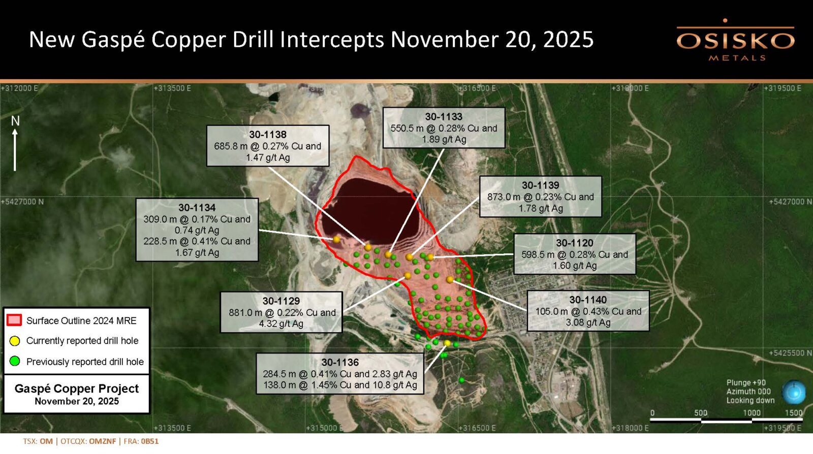
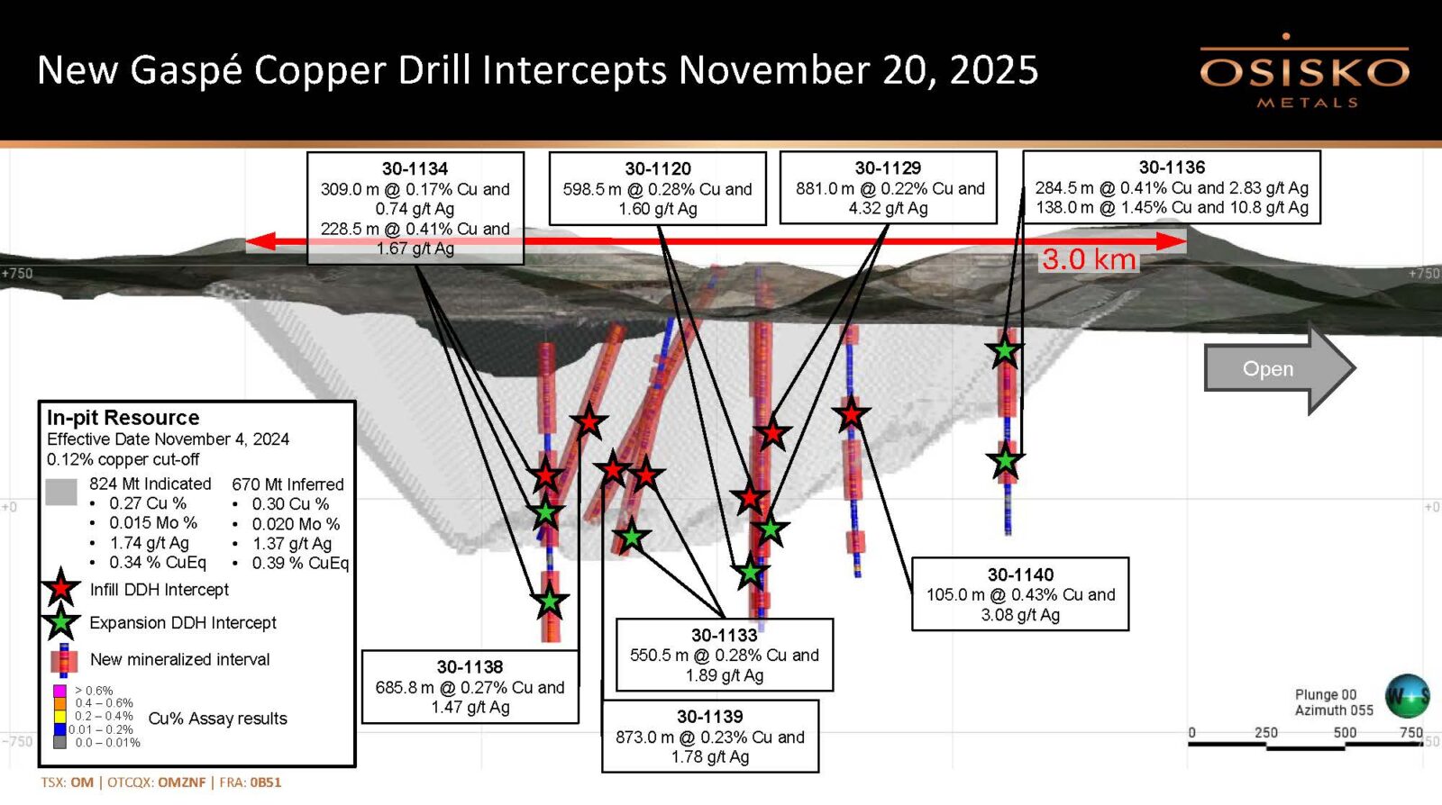
New analytical results are presented below (see Table 1), including 21 mineralized intercepts from eight new drill holes. Infill intercepts are located inside the 2024 MRE model (see November 14, 2024 news release), and are focused on upgrading inferred mineral resources to measured or indicated categories, as applicable. Expansion intercepts are located outside the 2024 MRE model and may potentially lead to additional resources that will be classified appropriately within the next MRE update. Some of the reported intercepts have contiguous shallower infill as well as deeper expansion (noted on Table 1 below as “Both”). Maps showing hole locations are available at www.osiskometals.com.
Highlights:
Table 1: Infill and Expansion Drilling Results
| DDH No. | From (m) | To (m) | Length (m) | Cu % | Ag g/t | Mo % | CuEq* % | Type** |
| 30-1120 | 143.0 | 415.5 | 272.5 | 0.22 | 1.84 | 0.005 | 0.25 | Infill |
| And | 541.5 | 1140.0 | 598.5 | 0.28 | 1.60 | 0.023 | 0.37 | Both |
| (including) | 541.5 | 784.1 | 242.6 | 0.22 | 1.60 | 0.023 | 0.32 | Infill |
| (including) | 784.1 | 1140.0 | 355.9 | 0.32 | 1.60 | 0.024 | 0.42 | Expansion |
| 30-1129 | 16.9 | 897.9 | 881.0 | 0.22 | 4.32 | 0.014 | 0.30 | Both |
| (including) | 16.9 | 645.9 | 629.0 | 0.23 | 1.61 | 0.011 | 0.28 | Infill |
| (including) | 645.9 | 897.9 | 252.0 | 0.20 | 2.08 | 0.023 | 0.30 | Expansion |
| And | 1013.6 | 1063.5 | 49.9 | 0.21 | 2.70 | 0.009 | 0.25 | Expansion |
| 30-1133 | 26.0 | 51.0 | 25.0 | 0.24 | 1.74 | <0.005 | 0.25 | Infill |
| And | 205.5 | 226.5 | 21.0 | 0.11 | 1.31 | 0.009 | 0.15 | Infill |
| And | 247.5 | 294.0 | 46.5 | 0.12 | 1.08 | 0.011 | 0.17 | Infill |
| And | 310.5 | 861.0 | 550.5 | 0.28 | 1.89 | 0.018 | 0.36 | Both |
| (including) | 310.5 | 744.0 | 433.5 | 0.28 | 1.79 | 0.018 | 0.36 | Infill |
| (including) | 744.0 | 861.0 | 117.0 | 0.3 | 2.27 | 0.019 | 0.38 | Expansion |
| 30-1134 | 46.5 | 339.0 | 292.5 | 0.17 | 0.81 | 0.008 | 0.20 | Infill |
| And | 393.0 | 702.0 | 309.0 | 0.17 | 0.74 | 0.027 | 0.27 | Both |
| (including) | 393.0 | 577.1 | 184.1 | 0.18 | 0.84 | 0.021 | 0.26 | Infill |
| (including) | 577.1 | 702.0 | 124.9 | 0.14 | 0.60 | 0.037 | 0.28 | Expansion |
| And | 780.0 | 1008.5 | 228.5 | 0.41 | 1.67 | 0.027 | 0.52 | Expansion |
| 30-1136 | 17.0 | 301.5 | 284.5 | 0.41 | 2.83 | <0.005 | 0.43 | Expansion |
| (including) | 151.5 | 169.5 | 18.0 | 1.35 | 7.40 | <0.005 | 1.42 | Expansion |
| And | 376.5 | 514.5 | 138.0 | 1.45 | 10.8 | <0.005 | 1.52 | Expansion |
| (including) | 379.5 | 444.0 | 64.5 | 2.70 | 19.0 | <0.005 | 2.82 | Expansion |
| 30-1138 | 29.7 | 715.5 | 685.8 | 0.27 | 1.47 | 0.018 | 0.35 | Infill |
| 30-1139 | 7.0 | 26.0 | 19.0 | 0.35 | 2.59 | <0.005 | 0.37 | Infill |
| And | 78.0 | 951.0 | 873.0 | 0.23 | 1.78 | 0.011 | 0.29 | Infill |
| 30-1140 | 5.5 | 61.0 | 55.5 | 0.29 | 2.08 | <0.005 | 0.30 | Infill |
| And | 124.5 | 187.5 | 63.0 | 0.16 | 1.90 | 0.011 | 0.22 | Infill |
| And | 355.5 | 460.5 | 105.0 | 0.43 | 3.08 | 0.012 | 0.50 | Infill |
| And | 493.8 | 687.0 | 193.2 | 0.16 | 1.10 | 0.021 | 0.25 | Both |
| (including) | 493.8 | 609.0 | 115.2 | 0.16 | 1.17 | 0.026 | 0.27 | Infill |
| (including) | 609.0 | 687.0 | 78.0 | 0.16 | 1.01 | 0.014 | 0.22 | Expansion |
| And | 787.3 | 856.5 | 69.2 | 0.22 | 1.33 | 0.039 | 0.37 | Expansion |
* See explanatory notes below on copper equivalent values and Quality Assurance/Quality Controls.
** “Both” indicates drill holes that have contiguous shallower infill as well as deeper expansion intercepts.
Discussion
Drill hole 30-1120, located on top of Copper Mountain near the centre of the 2024 MRE model, cut two significant mineralized intervals including 272.5 metres averaging 0.22 % Cu and 1.84 g/t Ag, followed by 598.5 metres averaging 0.28% Cu, 1.60 g/t Ag and 0.023% Mo, extending mineralization in this area to a vertical depth of 1140 metres.
Drill hole 30-1129, located on the western flank of Copper Mountain, cut two mineralized intervals including 881.0 metres averaging 0.22 % Cu and 4.32 g/t Ag and 0.014% Mo (which includes 200 metres of depth expansion), extending mineralization in this area to a vertical depth of 897.9 metres.
Drill hole 30-1133, located on the western flank of Copper Mountain, cut three mineralized intervals including 550.5 metres averaging 0.28 % Cu, 1.89 g/t Ag and 0.018% Mo (infill). This hole extended mineralization in this area to a vertical depth of 831 metres, ending in the porphyry intrusion core of the Copper Mountain deposit.
Drill hole 30-1134, located near the south-western lip of the Copper Mountain open pit, cut three mineralized intervals including 309.0 metres averaging 0.17 % Cu, 0.74 g/t Ag and 0.027% Mo (infill) as well as a deeper intersection of 228.5 metres averaging 0.41 % Cu, 1.67 g/t Ag and 0.027% Mo (expansion), extending mineralization in this area to a vertical depth of 1008.5 metres.
Drill hole 30-1136, located 125 metres south of the southern margin of the 2024 MRE model, cut two mineralized intersections, all expansion outside the current resource model, including 284.5 metres averaging 0.41 % Cu and 2.83 g/t Ag within (and above) the B and C Zone skarn horizons, as well as 138.0 metres averaging 1.45 % Cu and 10.8 g/t Ag from 45 metres above the E Zone horizon to 88 metres below it. This latter intersection included a high-grade interval of 64.5 metres averaging 2.70 % Cu and 19.0 g/t Ag that comprised dense sulfide vein/breccia zones located above and below the E Zone horizon, the latter consisting of replacement massive sulfides averaging 9.1% Cu over 4.5 metres. The vein/breccia zones are similar to what was encountered in drill hole 30-1128, located 95 metres west of 30-1136 (see November 12, 2025 news release). The massive sulfides in drill hole 30-1136 are located in what was previously described as the tabular E-28 Zone at Gaspé Copper, defined over a 240 m X 40 m area but never mined. However, the sulfide vein/breccia zones around the E Zone horizon were not previously documented in this area, and their extent and orientation are presently unknown.
Drill hole 30-1138, located near the southern lip of the Copper Mountain open pit, cut one mineralized interval of 685.8 metres averaging 0.27 % Cu, 1.47 g/t Ag and 0.018% Mo (infill). This hole confirmed mineralization in this area to a vertical depth of 725 metres, ending in the porphyry intrusion core of the Copper Mountain deposit.
Drill hole 30-1139, located on top of Copper Mountain near the centre of the 2024 MRE model, cut two significant mineralized intervals including 873.0 metres averaging 0.23 % Cu, 1.78 g/t Ag and 0.011% Mo confirming mineralization in this area to a vertical depth of 815 metres.
Drill hole 30-1140, located near the eastern margin of the 2024 MRE model, cut five intersections of mineralization, 55 to 193 metres thick and distributed in “layer cake” fashion from surface, including 105.0 metres averaging 0.43 % Cu, 3.08 g/t Ag and 0.012% Mo extending mineralization in this area to a vertical depth of 856 metres.
Mineralization at Gaspé Copper is of porphyry copper/skarn type and occurs as disseminations and stockworks of chalcopyrite with pyrite or pyrrhotite and minor bornite and molybdenite. One prograde and at least five retrograde vein/stockwork mineralizing events have been recognized at Copper Mountain, which overprint earlier, bedding replacement skarn and porcellanite-hosted mineralization throughout the Gaspé Copper system. Porcellanite is a historical mining term used to describe bleached, pale green to white potassic-altered hornfels. Subvertical stockwork mineralization dominates at Copper Mountain whereas prograde bedding-parallel mineralization, that is mostly stratigraphically controlled, dominates in the area of lower Copper Mountain, Needle Mountain, Needle East, and Copper Brook. High molybdenum grades (up to 0.5% Mo) were locally obtained in both the C Zone and E Zone skarns away from Copper Mountain.
The 2022 to 2024 Osisko Metals drill programs were focused on defining open-pit resources within the Copper Mountain stockwork mineralization (see May 6, 2024 MRE press release). Extending the resource model south of Copper Mountain into the poorly-drilled prograde skarn/porcellanite portion of the system subsequently led to a significantly increased resource, mostly in the Inferred category (see November 14, 2024 MRE press release).
The current drill program is designed to convert the November 2024 MRE to Measured and Indicated categories, as well as test the expansion of the system deeper into the stratigraphy and laterally to the south and southwest towards Needle East and Needle Mountain respectively. The November 2024 MRE was limited at depth to the base of the L1 skarn horizon (C Zone), and all mineralized intersections below this horizon represent potential depth extensions to the deposit, to be included in the next scheduled MRE update in Q1 2026.
Most holes are being drilled sub-vertically into the altered calcareous stratigraphy that dips 20 to 25 degrees to the north. The L1 (C Zone) the L2 (E Zone) skarn/marble horizons were intersected in most holes, as well as intervening porcellanites that host the bulk of the disseminated copper mineralization.
Table 2: Drill hole locations
| DDH No. | Azimuth (°) | Dip (°) | Length (m) | UTM E | UTM N | Elevation |
| 30-1120 | 0.0 | -90.0 | 1141.0 | 316225.0 | 5426398.0 | 742.5 |
| 30-1129 | 0.0 | -90.0 | 1140.0 | 316000.0 | 5426215.0 | 709.9 |
| 30-1133 | 0.0 | -75.0 | 861.0 | 315800.0 | 5426324.0 | 658.5 |
| 30-1134 | 0.0 | -90.0 | 1008.5 | 315300.0 | 5426573.0 | 547.4 |
| 30-1136 | 0.0 | -90.0 | 681.0 | 316389.0 | 5425544.0 | 563.0 |
| 30-1138 | 358.0 | -69.0 | 783.0 | 315612.0 | 5426495.0 | 583.0 |
| 30-1139 | 0.0 | -59.0 | 951.0 | 316020.0 | 5426400.0 | 744.0 |
| 30-1140 | 0.0 | -90.0 | 936.0 | 316417.0 | 5426177.0 | 682.1 |
Explanatory note regarding copper-equivalent grades
Copper Equivalent grades are expressed for purposes of simplicity and are calculated taking into account: 1) metal grades; 2) estimated long-term prices of metals: US$4.25/lb copper, $20.00/lb molybdenum, and US$24/oz silver; 3) estimated recoveries of 92%, 70%, and 70% for Cu, Mo, and Ag respectively; and 4) net smelter return value of metals as percentage of the price, estimated at 86.5%, 90.7%, and 75.0% for Cu, Mo, and Ag respectively.
About Osisko Metals
Osisko Metals Incorporated is a Canadian exploration and development company creating value in the critical metals sector, with a focus on copper and zinc. The Company acquired a 100% interest in the past-producing Gaspé Copper mine from Glencore Canada Corporation in July 2023. The Gaspé Copper mine is located near Murdochville in Québec‘s Gaspé Peninsula. The Company is currently focused on resource expansion of the Gaspé Copper system, with current Indicated Mineral Resources of 824 Mt averaging 0.34% CuEq and Inferred Mineral Resources of 670 Mt averaging 0.38% CuEq (in compliance with NI 43-101). For more information, see Osisko Metals’ November 14, 2024 news release entitled “Osisko Metals Announces Significant Increase in Mineral Resource at Gaspé Copper”. Gaspé Copper hosts the largest undeveloped copper resource in eastern North America, strategically located near existing infrastructure in the mining-friendly province of Québec.
In addition to the Gaspé Copper project, the Company is working with Appian Capital Advisory LLP through the Pine Point Mining Limited joint venture to advance one of Canada‘s largest past-producing zinc mining camps, the Pine Point project, located in the Northwest Territories. The current mineral resource estimate for the Pine Point project consists of Indicated Mineral Resources of 49.5 Mt averaging 5.52% ZnEq and Inferred Mineral Resources of 8.3 Mt averaging 5.64% ZnEq (in compliance with NI 43-101). For more information, see Osisko Metals‘ June 25, 2024 news release entitled “Osisko Metals releases Pine Point mineral resource estimate: 49.5 million tonnes of indicated resources at 5.52% ZnEq”. The Pine Point project is located on the south shore of Great Slave Lake, NWT, close to infrastructure, with paved road access, an electrical substation and 100 kilometres of viable haul roads.
For further information on this news release, visit www.osiskometals.com or contact:
Don Njegovan, President
Email: info@osiskometals.com
Phone: (416) 500-4129
Brutus Mining Inc. (CSE: BRU) (FSE: ZI3) is pleased to announce that it has closed its non-brokered ... READ MORE
Jaguar Uranium Corp. (NYSE American: JAGU) is pleased to announce an independent Mineral Resource E... READ MORE
Auro Metals Inc. (TSX-V: AURO) (OTCQB: AURFF), is pleased to announce the assay results of the fina... READ MORE
Endeavour Silver Corp. (NYSE: EXK) (TSX: EDR) is pleased to announce that repairs to the primary bal... READ MORE
Scorpio Gold Corp. (NASDAQ: SGLD) (TSX-V: SGLD) (OTCQB: SRCRF) (FSE: RY9) is pleased to announce re... READ MORE


