


![]()
HIGHLIGHTS
Osisko Development Corp. (NYSE: ODV) (TSX-V: ODV) is pleased to announce new infill drilling results from its ongoing 13,000-meter program on 10 meter drill spacing that commenced in August 2025 in the Lowhee Zone of the Company’s permitted, 100%-owned Cariboo Gold Project, located in central British Columbia, Canada. The first three fans of this program consisted of approximately 2,279 meters of underground infill drilling.
Chris Lodder, President, stated, “We have observed good continuity consistent with modelled vein zones and planned stope shapes with these initial results. The presence of high-grade composites within and adjacent to modelled reserve stopes is encouraging and highlights the value of systematic underground infill drilling. The success we are seeing underscores the potential and prospectivity of delineating new zones and expanding existing ones near planned infrastructure, which could be drilled off and incorporated into a future mine plan. The comprehensive 13,000-meter drill program is designed to deliver important data for resource modelling, mine planning, and optimization of production stope design. We look forward to providing further updates as drilling progresses.”
DRILL ASSAY HIGHLIGHTS
This news release includes assays from twenty-four (24) underground infill and exploration HQ diamond drill holes (63.5-millimeter diameter) totaling approximately 2,279 m completed from August 2025 through early September 2025 (see Table 1) and for which assays were received by October 1, 2025, with depths ranging from 54 to 114 m drilled on 3 fans at 40 m spaced fans (Figure 2). Select assay photon assay highlights include:
Complete assay highlights, including true width estimates, are presented in Table 1 and drill hole locations and orientations are listed in Table 2. Intervals not recovered by drilling were assigned zero grade. Top cuts have not been applied to high grade assays.
Figure 1: Cariboo Gold Project deposit map with Location of Lowhee Zone and Cow Portal underground access.
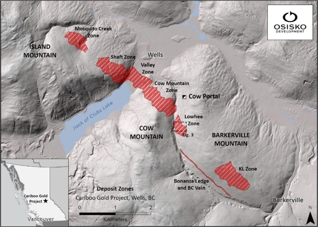
Figure 2: Location and overview of the ongoing 13,000-meter infill drilling campaign.
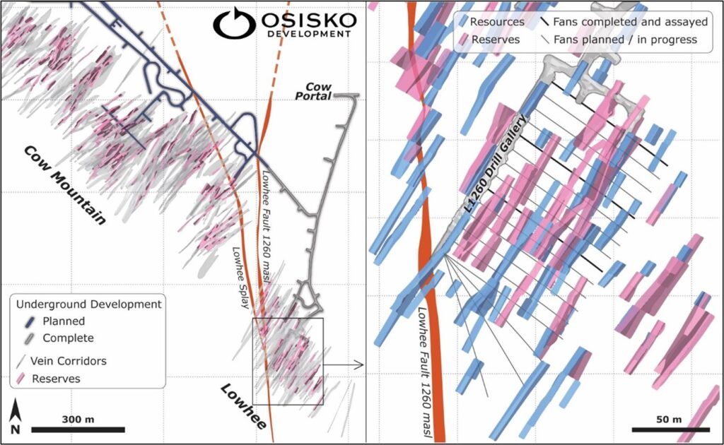
Figure 3: Lowhee Zone infill select underground drilling highlights, plan view.
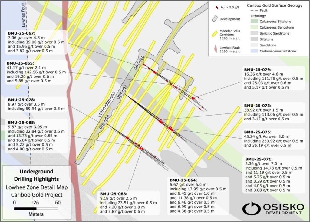
Figure 4: Lowhee Zone infill select underground drilling highlights in cross section by fan.
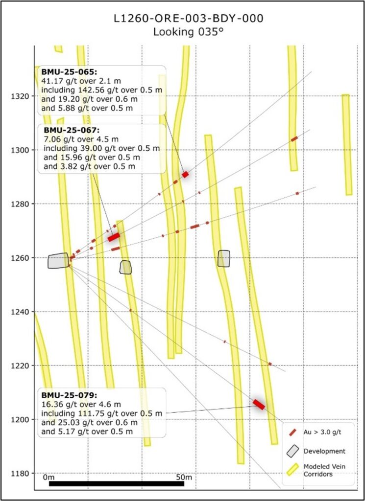
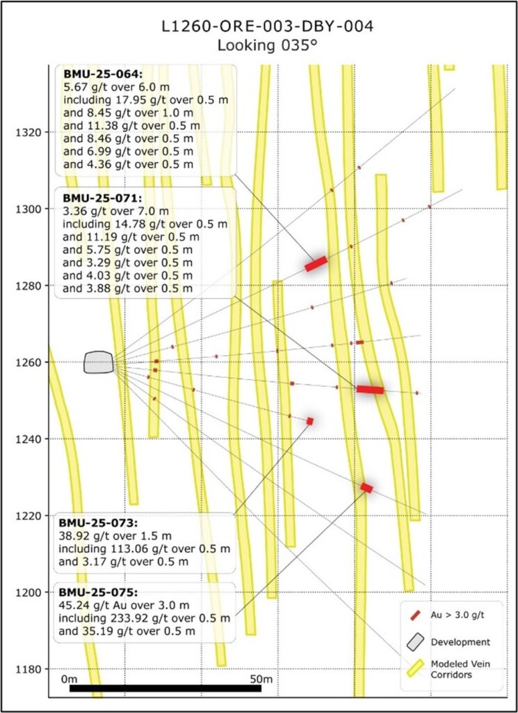
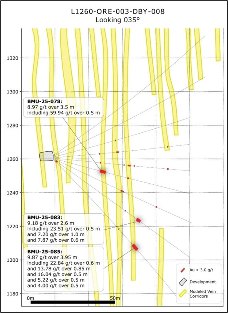
Table 1: Length weighted assay composites and individual samples>=3.0 g/t for Lowhee Zone underground DD.
| Drillhole ID | From (m) | To (m) | Length (m) | Au (g/t) | Est. True Width (m) | |
| BMU-25-061 | No significant assays | |||||
| BMU-25-062 | 72 | 72.5 | 0.5 | 4.87 | 0.41 | |
| 81.3 | 81.8 | 0.5 | 13.70 | 0.41 | ||
| BMU-25-063 | No significant assays | |||||
| BMU-25-064 | 56 | 62 | 6 | 5.67 | 5.75 | |
| Including | 56 | 56.5 | 0.5 | 11.38 | ||
| and | 58 | 58.5 | 0.5 | 17.95 | ||
| and | 58.5 | 59 | 0.5 | 6.99 | ||
| and | 59.5 | 60 | 0.5 | 8.46 | ||
| and | 60 | 60.5 | 0.5 | 4.36 | ||
| and | 61 | 62 | 1 | 8.45 | ||
| 69 | 69.5 | 0.5 | 3.21 | 0.43 | ||
| 84.2 | 84.7 | 0.5 | 5.10 | 0.43 | ||
| 91.95 | 92.45 | 0.5 | 19.76 | 0.32 | ||
| BMU-25-065 | 2.2 | 2.75 | 0.55 | 5.29 | 0.46 | |
| 3.75 | 5.25 | 1.5 | 3.59 | 1.30 | ||
| Including | 4.65 | 5.25 | 0.6 | 6.98 | ||
| 10.7 | 12.2 | 1.5 | 4.19 | 1.36 | ||
| Including | 10.7 | 11.2 | 0.5 | 11.77 | ||
| 17.5 | 18 | 0.5 | 15.99 | 0.43 | ||
| 20.5 | 21.5 | 1 | 3.57 | 0.91 | ||
| Including | 21 | 21.5 | 0.5 | 6.64 | ||
| 41.05 | 41.6 | 1.1 | 4.44 | 0.48 | ||
| 48.1 | 49.6 | 1.5 | 6.61 | 1.44 | ||
| Including | 48.1 | 48.6 | 0.5 | 5.25 | ||
| and | 48.6 | 49.1 | 0.5 | 4.03 | ||
| and | 49.1 | 49.6 | 0.5 | 10.54 | ||
| 52.4 | 54.5 | 2.1 | 41.17 | 1.25 | ||
| Including | 52.4 | 52.9 | 0.5 | 5.88 | ||
| and | 52.9 | 53.4 | 0.5 | 142.56 | ||
| and | 53.4 | 54 | 0.6 | 19.20 | ||
| BMU-25-066 | 16 | 16.5 | 0.5 | 3.51 | 0.47 | |
| 54 | 54.5 | 0.5 | 6.67 | 0.47 | ||
| 75.7 | 76.2 | 0.5 | 4.83 | 0.47 | ||
| BMU-25-067 | 0.7 | 2.7 | 2 | 3.63 | 1.29 | |
| Including | 0.7 | 1.2 | 0.5 | 4.00 | ||
| and | 1.2 | 1.7 | 0.5 | 8.16 | ||
| 9 | 10 | 1 | 11.09 | 0.94 | ||
| Including | 9.5 | 10 | 0.5 | 21.74 | ||
| 16.5 | 21 | 4.5 | 7.06 | 4.23 | ||
| Including | 16.5 | 17 | 0.5 | 15.96 | ||
| and | 17.5 | 18 | 0.5 | 39.00 | ||
| and | 20.5 | 21 | 0.5 | 3.82 | ||
| 47.5 | 48 | 0.5 | 3.55 | 0.32 | ||
| 54.35 | 54.85 | 0.5 | 10.25 | 0.45 | ||
| 93.9 | 96.5 | 2.6 | 5.56 | 2.29 | ||
| Including | 93.9 | 94.4 | 0.5 | 14.37 | ||
| and | 94.4 | 94.9 | 0.5 | 4.59 | ||
| and | 95.9 | 96.5 | 0.6 | 7.67 | ||
| BMU-25-068 | 11 | 12 | 1 | 6.86 | 0.95 | |
| Including | 11.5 | 12 | 0.5 | 13.38 | ||
| 27 | 27.5 | 0.5 | 4.06 | 0.49 | ||
| 43 | 43.5 | 0.5 | 4.94 | 0.49 | ||
| 57.5 | 58 | 0.5 | 3.76 | 0.49 | ||
| 62.5 | 63 | 0.5 | 4.28 | 0.49 | ||
| 64 | 66 | 2 | 3.13 | 1.97 | ||
| Including | 65 | 65.5 | 0.5 | 5.40 | ||
| and | 65.5 | 66 | 0.5 | 3.39 | ||
| BMU-25-069 | 0.7 | 1.2 | 0.5 | 13.40 | 0.43 | |
| 16.5 | 19.65 | 3.15 | 3.48 | 3.12 | ||
| Including | 17.6 | 18.15 | 0.55 | 15.63 | ||
| and | 19.15 | 19.65 | 0.5 | 3.08 | ||
| 36 | 36.6 | 0.6 | 7.55 | 0.54 | ||
| 41.3 | 42.45 | 1.15 | 8.64 | 1.08 | ||
| Including | 41.85 | 42.45 | 0.6 | 14.98 | ||
| 47 | 50.3 | 3.3 | 3.63 | 3.10 | ||
| Including | 48.3 | 48.8 | 0.5 | 21.51 | ||
| 53 | 54 | 1 | 3.83 | 0.87 | ||
| Including | 53 | 53.5 | 0.5 | 3.37 | ||
| and | 53.5 | 54 | 0.5 | 4.29 | ||
| 88.15 | 89.15 | 1 | 5.13 | 0.94 | ||
| Including | 88.15 | 88.65 | 0.5 | 8.48 | ||
| BMU-25-070 | 37.5 | 38 | 0.5 | 9.73 | 0.43 | |
| BMU-25-071 | 10.5 | 11.5 | 1 | 4.45 | 0.94 | |
| Including | 10.5 | 11 | 0.5 | 4.08 | ||
| and | 11 | 11.5 | 0.5 | 4.83 | 0.47 | |
| 46.5 | 47.5 | 1 | 4.23 | 0.94 | ||
| Including | 46.5 | 47 | 0.5 | 7.91 | 0.47 | |
| 58.5 | 59 | 0.5 | 4.73 | 0.48 | ||
| 64 | 71 | 7 | 3.36 | 6.98 | ||
| Including | 64.5 | 65 | 0.5 | 11.19 | ||
| and | 65.5 | 66 | 0.5 | 3.29 | ||
| and | 67.5 | 68 | 0.5 | 4.03 | ||
| and | 68 | 68.5 | 0.5 | 5.75 | ||
| and | 69.5 | 70 | 0.5 | 3.88 | ||
| and | 70 | 70.5 | 0.5 | 14.78 | ||
| 79.5 | 80 | 0.5 | 4.92 | 0.49 | ||
| BMU-25-072 | 0.2 | 0.7 | 0.5 | 6.53 | 0.48 | |
| 64.5 | 65 | 0.5 | 12.27 | 0.49 | ||
| 83 | 84 | 1 | 4.22 | 0.87 | ||
| Including | 83 | 83.5 | 0.5 | 8.09 | ||
| BMU-25-073 | 9.2 | 9.7 | 0.5 | 3.48 | 0.50 | |
| 21.5 | 22 | 0.5 | 10.15 | 0.45 | ||
| 47.5 | 48 | 0.5 | 4.27 | 0.47 | ||
| 52.5 | 54 | 1.5 | 38.92 | 1.49 | ||
| Including | 52.5 | 53 | 0.5 | 3.17 | ||
| and | 53.5 | 54 | 0.5 | 113.06 | ||
| BMU-25-074 | 26.85 | 27.35 | 0.5 | 4.63 | 0.50 | |
| 37.1 | 38.6 | 1.5 | 5.35 | 1.30 | ||
| Including | 37.1 | 37.6 | 0.5 | 13.16 | ||
| 67.5 | 68 | 0.5 | 3.87 | 0.48 | ||
| BMU-25-075 | 71.5 | 74.5 | 3 | 45.24 | 2.38 | |
| Including | 72 | 72.5 | 0.5 | 233.92 | ||
| and | 73.5 | 74 | 0.5 | 35.19 | ||
| BMU-25-076 | 12.8 | 13.3 | 0.5 | 19.24 | 0.45 | |
| BMU-25-077 | 27.05 | 27.55 | 0.5 | 10.96 | 0.50 | |
| 41.15 | 41.65 | 0.5 | 29.90 | 0.45 | ||
| 43.85 | 45.35 | 1.5 | 3.34 | 1.50 | ||
| Including | 43.85 | 44.35 | 0.5 | 5.79 | ||
| and | 44.85 | 45.35 | 0.5 | 3.97 | ||
| 47.25 | 47.75 | 0.5 | 28.26 | 0.50 | ||
| 67 | 68 | 1 | 5.69 | 1.00 | ||
| Including | 67.5 | 68 | 0.5 | 10.99 | ||
| BMU-25-078 | 27.85 | 31.35 | 3.5 | 8.97 | 3.17 | |
| Including | 30.85 | 31.35 | 0.5 | 59.94 | ||
| 44.8 | 45.8 | 1 | 3.13 | 1.00 | ||
| Including | 45.3 | 45.8 | 0.5 | 4.32 | ||
| BMU-25-079 | BMU-25-079 | 28.1 | 28.6 | 0.5 | 39.84 | 0.35 |
| 85.2 | 89.8 | 4.6 | 16.36 | 3.98 | ||
| Including | 85.7 | 86.2 | 0.5 | 5.17 | ||
| and | 86.2 | 86.8 | 0.6 | 25.03 | ||
| and | 89.3 | 89.8 | 0.5 | 111.75 | ||
| BMU-25-080 | No Significant Assays | |||||
| BMU-25-081 | 43.5 | 45.5 | 2 | 4.06 | 1.73 | |
| Including | 43.5 | 44 | 0.5 | 7.89 | ||
| and | 44 | 44.5 | 0.5 | 7.00 | ||
| 66.5 | 67.2 | 0.7 | 6.75 | |||
| BMU-25-082 | No Significant Assays | |||||
| BMU-25-083 | 1.35 | 2.5 | 1.15 | 3.40 | 1.06 | |
| Including | 1.35 | 2 | 0.65 | 5.12 | ||
| 51.9 | 52.4 | 0.5 | 34.55 | 0.38 | ||
| 60.5 | 63.1 | 2.6 | 9.18 | 2.28 | ||
| Including | 61 | 62 | 1 | 7.20 | ||
| and | 62 | 62.5 | 0.5 | 23.51 | ||
| and | 62.5 | 63.1 | 0.6 | 7.87 | ||
| BMU-25-085 | 56.6 | 57.1 | 0.5 | 26.70 | 0.41 | |
| 69.45 | 73.4 | 3.95 | 9.87 | 3.58 | ||
| Including | 69.45 | 69.95 | 0.5 | 4.00 | ||
| and | 69.95 | 70.8 | 0.85 | 13.78 | ||
| and | 71.8 | 72.3 | 0.5 | 16.04 | ||
| and | 72.3 | 72.9 | 0.6 | 22.84 | ||
| and | 72.9 | 73.4 | 0.5 | 5.22 | ||
Table 2: Underground DD collar locations, drillhole orientations, and max depths. Negative dips point down.
| Drillhole ID | Mine Location | Easting (UTM z12N) |
Northing (UTM z12N) |
Elevation (m) |
Dip | Azimuth | Depth (m) |
| BMU-25-061 | L1260-ORE-003-DBY-008 | 596468.7 | 5882768.6 | 1262.3 | -35 | 125 | 114 |
| BMU-25-062 | L1260-ORE-003-DBY-004 | 596488.9 | 5882802.9 | 1261.0 | -35 | 125 | 114 |
| BMU-25-063 | L1260-ORE-003-DBY-008 | 596468.4 | 5882768.8 | 1261.6 | -25 | 125 | 102 |
| BMU-25-064 | L1260-ORE-003-DBY-004 | 596488.9 | 5882803.0 | 1260.2 | -25 | 125 | 102 |
| BMU-25-065 | L1260-ORE-003-DBY-000 | 596510.0 | 5882837.7 | 1259.8 | -35 | 125 | 114 |
| BMU-25-066 | L1260-ORE-003-DBY-004 | 596488.9 | 5882803.0 | 1259.8 | -15 | 125 | 80 |
| BMU-25-067 | L1260-ORE-003-DBY-000 | 596510.1 | 5882837.6 | 1259.4 | -25 | 125 | 102 |
| BMU-25-068 | L1260-ORE-003-DBY-004 | 596488.9 | 5882802.9 | 1259.3 | -5 | 125 | 81 |
| BMU-25-069 | L1260-ORE-003-DBY-000 | 596510.1 | 5882837.6 | 1258.7 | -14 | 125 | 96 |
| BMU-25-070 | L1260-ORE-003-DBY-008 | 596468.8 | 5882768.6 | 1261.2 | -15 | 125 | 84 |
| BMU-25-071 | L1260-ORE-003-DBY-004 | 596489.1 | 5882802.9 | 1258.9 | 5 | 125 | 81 |
| BMU-25-072 | L1260-ORE-003-DBY-000 | 596510.1 | 5882837.6 | 1257.3 | 25 | 125 | 90 |
| BMU-25-073 | L1260-ORE-003-DBY-004 | 596489.1 | 5882802.8 | 1258.6 | 15 | 125 | 54 |
| BMU-25-074 | L1260-ORE-003-DBY-008 | 596468.8 | 5882768.5 | 1260.7 | -5 | 125 | 81 |
| BMU-25-075 | L1260-ORE-003-DBY-004 | 596489.2 | 5882802.8 | 1258.2 | 25 | 125 | 90 |
| BMU-25-076 | L1260-ORE-003-DBY-004 | 596489.2 | 5882802.9 | 1258.0 | 35 | 125 | 99 |
| BMU-25-077 | L1260-ORE-003-DBY-008 | 596469.1 | 5882768.4 | 1260.4 | 5 | 125 | 81 |
| BMU-25-078 | L1260-ORE-003-DBY-008 | 596469.0 | 5882768.4 | 1260.1 | 15 | 125 | 84 |
| BMU-25-079 | L1260-ORE-003-DBY-000 | 596510.0 | 5882837.6 | 1257.0 | 35 | 125 | 99 |
| BMU-25-080 | L1260-ORE-003-DBY-004 | 596489.0 | 5882803.0 | 1257.7 | 45 | 125 | 114 |
| BMU-25-081 | L1260-ORE-003-DBY-008 | 596468.9 | 5882768.5 | 1259.8 | 25 | 125 | 90 |
| BMU-25-082 | L1260-ORE-003-DBY-000 | 596510.2 | 5882837.8 | 1256.8 | 45 | 125 | 114 |
| BMU-25-083 | L1260-ORE-003-DBY-008 | 596468.7 | 5882768.6 | 1259.6 | 35 | 125 | 99 |
| BMU-25-085 | L1260-ORE-003-DBY-008 | 596468.3 | 5882768.9 | 1259.8 | 45 | 125 | 114 |
ABOUT LOWHEE ZONE
Geological mapping and geochemical sampling were carried out on Barkerville Mountain from 2017-2018, with the Lowhee Zone identified as a high-priority drill target.
In 2019, two southeast-oriented stratigraphic and 22 northwest-southeast oriented drillholes (8,337.0 m) were drilled at the Lowhee Zone. The drilling successfully identified auriferous quartz-carbonate veins at similar orientations to those observed elsewhere on the Cariboo Gold project. Initial 3D geological modelling and resource estimation commenced, and further drilling was recommended.
In 2020, 24 northwest-oriented diamond drillholes (10,144.5 m) were drilled. The focus of the exploration program was to test the extent of mineralization along the down-dip and northeast strike-extent of veining. An internal resource estimation of the Lowhee deposit was completed at that time, with further drilling recommended to improve confidence.
In 2021, a total of 94 diamond drillholes (29,449.1 m) were drilled. The focus of drilling was to delineate, and infill modelled veins with 25 m spacing. At the time, Barkerville Gold Mines Ltd. completed a mineral resource estimate, and the collection of a bulk sample was recommended.
In 2022, a total of 27 diamond drillholes (6,563.90 m) were drilled. There were two main goals with this drill program. The first goal was to infill a potential bulk sample location achieving category conversion from indicated (25 m spacing) to measured (12.5 m spacing). The second goal was to continue to delineate and infill modelled veins with 25 m spacing.
Lowhee zone access is through Cow portal on the northwestern flank of Barkerville Mountain (Figure 1 and Figure 2) Cow portal construction was completed in Q4 2024 and development of the underground ramp into the Lowhee zone commenced in Q1 2025. Approximately 350 m of development has been advanced within the Lowhee zone deposit at the 1,290 and 1,260-elevation levels since completion of the main access ramp. The probable mineral reserves estimate for the Lowhee Zone includes 104,491 ounces of contained Au (923,162 tonnes grading 3.52 g/t Au) and represents approximately 5% of the total contained gold in the estimated probable mineral reserves for the Cariboo Gold Project.
ABOUT CARIBOO GOLD PROJECT
The Cariboo Gold Project is a permitted, 100%-owned feasibility-stage project located in the historic Wells-Barkerville mining camp of central British Columbia, Canada. Spanning approximately 186,740 hectares, the Company’s land package includes 443 mineral titles and covers a ~77-kilometre strike of highly prospective exploration targets extending northwest to southeast. In late 2024, the Project was granted the Mines Act and Environmental Management Act (British Columbia) permits, marking the successful completion of the permitting process for key approvals, solidifying the Project’s shovel-ready status.
The Cariboo Gold Project hosts probable mineral reserves of 2.07 million ounces of contained Au (17,815 kt grading 3.62 g/t Au); measured mineral resources of 8,000 ounces of contained Au (47 kt grading 5.06 g/t Au); indicated mineral resources of 1.60 million ounces of contained Au (17,332 kt grading 2.88 g/t Au); and inferred mineral resources of 1.86 million ounces of contained Au (18,774 kt grading 3.09 g/t Au). Mineral resources are reported exclusive of mineral reserves.
Technical Reports
Information relating to the Cariboo Gold Project and the 2025 FS on the Cariboo Gold Project is supported by the technical report, titled “NI 43-101 Technical Report, Feasibility Study for the Cariboo Gold Project, District of Wells, British Columbia, Canada” and dated June 11, 2025 (with an effective date of April 25, 2025).
For readers to fully understand the information in the Cariboo Technical Report, reference should be made to the full text of the Cariboo Technical Report in its entirety, including all assumptions, parameters, qualifications, limitations and methods therein. The Technical Report is intended to be read as a whole, and sections should not be read or relied upon out of context. The Technical Report was prepared in accordance with National Instrument 43-101 – Standards of Disclosure for Mineral Projects and is available electronically on SEDAR+ (www.sedarplus.ca) and on EDGAR (www.sec.gov) under Osisko Development’s issuer profile and on the Company’s website at www.osiskodev.com.
Qualified Persons
The scientific and technical information contained in this news release has been reviewed, verified and approved by Eryn Doyle, P. Geo., Senior Exploration Manager of Osisko Development, a “qualified person” within the meaning of NI 43-101. Verification includes core photo and three-dimensional review of logged drillhole data and assays consistent with the Company’s standard procedures.
Quality Assurance – Quality Control
Whole core sampling is completed in the logging facilities following daily QAQC checks for logging and sampling errors. Quality control samples are inserted at regular intervals in the sample stream, including blanks and reference materials with all sample shipments to monitor laboratory performance. Samples are bagged, labeled, sealed with numbered security tags
Samples are taken by expeditor from the logging facilities direct to MSALABS’s analytical facility in Prince George, B.C., Canada, for preparation and analysis. The MSALABS facility is accredited to the ISO/IEC 17025 standard for gold assays and all analytical methods include quality control materials at set frequencies with established data acceptance criteria. The entire sample is dried, crushed, and split into sealed containers. Analysis for gold is by gamma ray analysis using the Chrysos PhotonAssay (PA1408X). Samples are bombarded with gamma rays and the resulting signal is sent to the detectors.
Alternatively Drill core samples are submitted to ALS Geochemistry’s analytical facility in North Vancouver, British Columbia for preparation and analysis. The ALS facility is accredited to the ISO/IEC 17025 standard for gold assays and all analytical methods include quality control materials at set frequencies with established data acceptance criteria. The entire sample is crushed, and 250 grams is pulverized. Analysis for gold is by 50 gram fire assay fusion with atomic absorption (AAS) finish with a lower limit of 0.01 ppm and upper limit of 100 ppm. Samples with gold assays greater than 100 ppm are re-analyzed using a 1,000-gram screen metallic fire assay. A selected number of samples are also analyzed using a 48 multi-elemental geochemical package by a 4-acid digestion, followed by Inductively Coupled Plasma Atomic Emission Spectroscopy (ICP-AES) and Inductively Coupled Plasma Mass Spectroscopy (ICP-MS).
ABOUT OSISKO DEVELOPMENT CORP.
Osisko Development Corp. is a continental North American gold development company focused on past-producing mining camps located in mining friendly jurisdictions with district scale potential. The Company’s objective is to become an intermediate gold producer by advancing its flagship permitted 100%-owned Cariboo Gold Project, located in central B.C., Canada. Its project pipeline is complemented by the Tintic Project in the historic East Tintic mining district in Utah, U.S.A., and the San Antonio Gold Project in Sonora, Mexico—brownfield properties with significant exploration potential, extensive historical mining data, access to existing infrastructure and skilled labour. The Company’s strategy is to develop attractive, long-life, socially and environmentally responsible mining assets, while minimizing exposure to development risk and growing mineral resources.
Hudbay Minerals Inc. (TSX:HBM) (NYSE: HBM) today released its ann... READ MORE
Strategic acquisition of an established operating gold mine, loca... READ MORE
Cerro de Pasco Resources Inc. (TSX-V: CDPR) (OTCQB: GPPRF) (FRA: ... READ MORE
The Garneau Titanium Project Features Ilmenite-Rich Boulder with ... READ MORE
ValOre Metals Corp. (TSX‐V: VO) (OTCQB: KVLQF) (Frankfurt: KEQ0... READ MORE


