








Drilling Continues to Define Higher-Grade Plunging Mineralization within the 1.4-km-long Argus Gold System
Onyx Gold Corp. (TSX-V: ONYX) (OTCQX: ONXGF) is pleased to report assay results from an additional nine drill holes from the Argus Gold System at its 100%-owned Munro-Croesus Project, located 75 kilometers east of Timmins, Ontario. (Figure 4).
Results reported today are from the Argus Main and Argus West zones, two of several mineralized zones being explored within the broader Argus Gold System.
At Argus Main, drill hole MC26-340 returned one of the strongest higher-grade intersections drilled in the zone to date, grading 1.7 g/t gold over 67.0 meters, including 4.1 g/t Au over 24.5 m and 13.2 g/t Au over 6.0 m, including 73.4 g/t Au over 1.0 m associated with visible gold (Plate 1). Hole MC26-329, drilled approximately 150 m down-dip, returned a broad interval of 0.7 g/t Au over 144.5 m, including 1.1 g/t Au over 75.0 m and 2.1 g/t Au over 21.3 m.
The results further define a higher-grade plunging zone at Argus Main within a much broader envelope of gold mineralization. A similar relationship between broad mineralized envelopes and higher-grade plunging zones has been identified at Argus North, approximately 600 m to the west.
The Argus Gold System has now demonstrated gold mineralization across multiple zones over approximately 1.4 km of strike and more than 700 m vertically, while remaining open along strike, at depth and down-plunge. The Company’s 110,000 m drill program is approximately 75% complete, with four drill rigs currently operating.
Highlights from Argus Main
“Hole 340 is one of the strongest higher-grade intersections we have drilled at Argus Main to date and provides another important piece of the emerging picture at the Argus Gold System,” stated Brock Colterjohn, President & CEO. “Within 67 meters grading 1.7 g/t gold, we are seeing 24.5 meters at 4.1 g/t and 6.0 meters at 13.2 g/t, including visible gold grading 73.4 g/t over one meter. The more we drill Argus Main, the better we are defining substantial higher-grade mineralization within the broader mineralized envelope.”
“Importantly, we are beginning to see this as a characteristic of the broader Argus Gold System rather than an isolated feature of any one drill hole. Argus Main, Argus North and Argus West are individual zones within a much larger mineralized system that we are still in the early stages of defining. With four rigs operating and over 27,000 meters remaining in our fully funded program, our priority is to continue expanding the known zones while systematically testing for additional centres of mineralization across the broader system.”
Click here to watch a short video with President & CEO Brock Colterjohn discussing the latest drill results and what they mean for the evolving Argus Gold System.
Argus Main Drill Results
Three drill holes reported today stepped up- and down-dip from previously reported Argus Main drilling as part of the Company’s strategy to define and expand the known zone.
Holes MC26-329 and MC26-340 were drilled on the same cross-section as previously reported holes MC26-267 and MC26-270, which returned 1.2 g/t Au over 99.5 m and 1.3 g/t Au over 77.2 m, respectively (see Company news release dated March 31, 2026). MC26-329 tested approximately 50 m below MC26-267, while MC26-340 tested approximately 75 m above MC26-270.
The third drill hole, MC26-335, encountered massive mafic volcanic rocks at the interpreted Argus Main target depth and returned no significant results. The hole may be extended in the future to test for a faulted continuation of the prospective variolitic volcanic stratigraphy.
Argus Main has now been defined from surface to approximately 400 m vertical depth and remains open along strike and at depth.
Mineralization at Argus Main shares important geological characteristics with Argus North, including moderate to strong albite-carbonate-silica alteration, fracturing and local crackle brecciation hosted within mafic variolitic to pillowed volcanic rocks containing fine-grained pyrite.
Drilling is increasingly defining multiple higher-grade plunging zones at Argus Main within the broader mineralized envelope. One drill rig remains dedicated to systematic expansion of Argus Main along strike and up and down plunge.
Argus West Drill Results
Six drill holes tested the western extension of Argus West, approximately 100 to 150 m west of previously reported hole MC25-213, which intersected 2.1 g/t Au over 21.2 m beginning 9.8 m downhole (Figure 1).
The latest drilling targeted the favourable stratigraphic horizon between upper and lower variolitic volcanic facies and its intersection with the northeast-trending Argus Fault at depth.
Five of the six holes returned gold mineralization, including:
Collectively, the drilling extends the Argus West mineralized corridor approximately 100 m west-southwest, with anomalous gold now intersected to approximately 300 m vertical depth.
Early drilling indicates that the northeast-trending Argus Fault may represent an important structural control on mineralization at Argus West, with alteration and mineralization sharing characteristics observed elsewhere within the Argus Gold System. Gold mineralization occurs within mafic variolitic volcanic rocks as well as Porcupine Group sedimentary rocks south of the fault.
Further drilling is planned to test for a more continuous higher-grade core within the Argus West corridor.
The Argus Gold System
The Argus Gold System is an emerging, large-scale gold system comprising multiple zones of mineralization immediately north of the regional Pipestone Fault. The currently recognized zones include Argus Main, Argus North and Argus West, with additional exploration targets currently being drill tested across the broader structural Pipestone and Argus Fault corridors.
Drilling to date has demonstrated gold mineralization across approximately 1.4 km of strike and more than 700 m vertically.
At Argus North and Argus Main, drilling indicates that broad zones of disseminated gold mineralization contain steeply plunging, higher-grade zones associated with northeast-trending structures and favourable volcanic stratigraphy. These higher-grade zones appear to occur at intervals along the broader mineralized trend, providing a geological framework for targeting additional zones across the system.
Onyx controls approximately 8 km of prospective strike along the Pipestone Fault corridor and approximately 16 km of the interpreted Argus Fault. Much of this broader structural-stratigraphic corridor remains lightly tested or undrilled.
The Company’s ongoing exploration strategy is therefore focused both on expanding the known Argus zones and testing prospective structural intersections for additional repetitions of mineralization elsewhere within the Argus Gold System.
Update on 2026 Exploration Program
Onyx continues to execute its fully funded 110,000 m exploration program at Munro-Croesus, with 206 drill holes totalling approximately 82,700 m completed to date.
Assays have been released for 140 drill holes, representing approximately 68% of holes completed, with approximately 27,300 m remaining to be drilled.
Four diamond drill rigs are currently operating at the Project. The ongoing program is focused on:
1) Expanding the Argus Gold System, including the higher-grade plunging zones at Argus Main and Argus North and the broader disseminated mineralized envelopes surrounding them;
2) Testing for additional mineralized centers where northeast-trending structures intersect favourable volcanic stratigraphy along the broader Pipestone Fault corridor and Argus Fault; and
3) Advancing surface exploration, including property-wide prospecting, geochemical sampling and mechanical stripping of selected areas where mineralization is exposed or interpreted to project to surface.
A 420 line-kilometer high-resolution drone magnetic survey has also been completed over the Argus Gold System and greater Pipestone corridor, with results expected shortly.
The Company anticipates completing the 110,000 m program by year-end and is fully funded with approximately $14 million in cash.
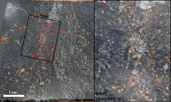
Plate 1 – Visible Gold in Drill Hole MC26-340 – 73.4 g/t Au over 1.0 m within 6.0 m Grading 13.2 g/t Au
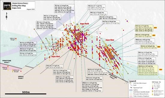
Figure 1 – Plan Map Highlighting Argus Zone Drill Holes Reported in this Release
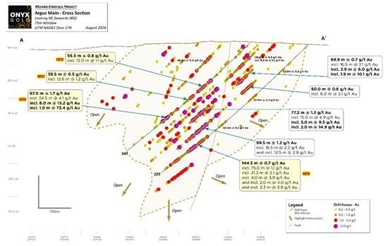
Figure 2 – Cross-Section Highlighting Argus Main Drill Holes Reported in this Release – Looking Northeast – 100m window
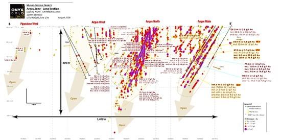
Figure 3 – Longitudinal Section Highlighting Argus Zone Plunging Shoots – Looking North – 1200 m window
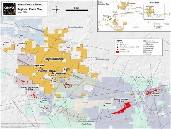
Figure 4 – Location of the Munro-Croesus Gold Project, Ontario
Table 1 – Significant Assay Results Reported in this Release
| Target | From | To | Length | Au |
| Drill Hole | (m) | (m) | (m) | (g/t) |
| Argus Main East | ||||
| MC26-329 | 102.5 | 125.3 | 22.8 | 0.2 |
| And | 219.0 | 251.0 | 32.0 | 0.3 |
| And | 343.0 | 371.0 | 28.0 | 0.2 |
| And | 415.0 | 559.5 | 144.5 | 0.7 |
| Including | 417.0 | 492.0 | 75.0 | 1.1 |
| Including | 461.0 | 482.3 | 21.3 | 2.1 |
| Including | 461.0 | 465.0 | 4.0 | 3.9 |
| And Including | 471.0 | 473.0 | 2.0 | 4.0 |
| And Including | 479.0 | 482.3 | 3.3 | 3.9 |
| And | 571.5 | 579.5 | 8.0 | 0.3 |
| MC26-335 | 198.0 | 204.0 | 6.0 | 0.4 |
| MC26-340 | 162.5 | 218.0 | 55.5 | 0.8 |
| Including | 187.5 | 199.5 | 12.0 | 1.1 |
| And | 234.5 | 274.0 | 39.5 | 0.5 |
| Including | 237.0 | 249.6 | 12.6 | 1.2 |
| And | 299.0 | 366.0 | 67.0 | 1.7 |
| Including | 334.5 | 359.0 | 24.5 | 4.1 |
| Including | 340.5 | 346.5 | 6.0 | 13.2 |
| Including | 341.5 | 342.5 | 1.0 | 73.4 |
| *All intersections are reported as drilled width; true width is 60-90% of drilled width | ||||
Table 1 (Continued)
| Target | From | To | Length | Au |
| Drill Hole | (m) | (m) | (m) | (g/t) |
| Argus West | ||||
| MC26-304 | 173.0 | 182.5 | 9.5 | 0.2 |
| And | 236.0 | 237.5 | 1.5 | 1.4 |
| And | 253.5 | 258.4 | 4.9 | 0.7 |
| Including | 256.5 | 257.5 | 1.0 | 1.7 |
| MC26-307 | 269.5 | 271.0 | 1.5 | 2.1 |
| And | 286.0 | 289.0 | 3.0 | 0.9 |
| MC26-309 | 268.0 | 277.0 | 9.0 | 0.5 |
| Including | 268.0 | 273.0 | 5.0 | 0.8 |
| Including | 268.0 | 269.0 | 1.0 | 1.9 |
| And | 352.7 | 353.7 | 1.0 | 2.6 |
| And | 380.0 | 381.0 | 1.0 | 1.6 |
| MC26-315 | No Significant Assays | |||
| MC26-320 | 95.0 | 96.0 | 1.0 | 1.5 |
| And | 217.0 | 220.0 | 3.0 | 1.0 |
| Including | 218.5 | 220.0 | 1.5 | 1.2 |
| And | 289.0 | 290.5 | 1.5 | 1.4 |
| MC26-323 | 138.5 | 140.0 | 1.5 | 0.7 |
| And | 156.0 | 160.5 | 4.5 | 0.3 |
| And | 214.0 | 222.5 | 8.5 | 0.2 |
| And | 338.5 | 343.0 | 4.5 | 0.3 |
| *All intersections are reported as drilled width; true width is 60-90% of drilled width | ||||
A table of all drill collar details and significant assay intersections released to date can be found on the Company website at https://onyxgold.com/projects/munro-croesus-gold/.
The Munro-Croesus Project
The Munro-Croesus Project is located along Highway 101 in the heart of the Abitibi greenstone belt, Canada’s premier gold mining jurisdiction (Figure 4). This large, 100%-owned land package includes the past-producing Croesus Gold Mine, which yielded some of the highest-grade gold ever mined in Ontario. Extensive land consolidation since 2020 has unified the patchwork of patented and unpatented mining claims surrounding the Croesus Gold Mine into one coherent package and enhanced the project’s exploration potential.
The Project covers 112 km2 of highly prospective geology within the influence of major gold-bearing structural breaks. Bulk-tonnage gold deposits located in the immediate region include the Fenn-Gib gold project being developed by Mayfair Gold Corp., and the Tower Gold Project being developed by STLLR Gold Inc.
About Onyx Gold
Onyx Gold Corp. is a Canadian exploration company focused on unlocking district-scale gold opportunities in two of the country’s most prolific and proven mining jurisdictions – Timmins, Ontario, and Yukon Territory.
In the Timmins Gold Camp, Onyx controls an extensive portfolio anchored by the Munro-Croesus Property, host to the historic high-grade Croesus Mine and site of the Company’s recent Argus North discovery – one of the most exciting new gold zones emerging in the camp. Complementing Munro-Croesus are two large, early-stage projects – Golden Mile, a 140 km² property situated just 9 km from Discovery Silver’s multi-million-ounce Hoyle Pond Mine, and Timmins South, a 187 km² land package strategically positioned around the Shaw Dome structure, offering exceptional discovery potential.
Beyond Ontario, Onyx holds a commanding land position across four properties in Yukon’s Selwyn Basin, an area rapidly gaining recognition for new gold discoveries and growing exploration investment. The Company’s King Tut Property sits approximately 50 km south of Snowline Gold’s Valley discovery and adjacent to Fireweed Metals’ MacPass property.
Led by an experienced team with a strong track record of discovery, development, and value creation, Onyx Gold is well-funded and committed to delivering shareholder value through disciplined exploration, strategic growth, and responsible resource development.
Brutus Mining Inc. (CSE: BRU) (FSE: ZI3) is pleased to announce that it has closed its non-brokered ... READ MORE
Jaguar Uranium Corp. (NYSE American: JAGU) is pleased to announce an independent Mineral Resource E... READ MORE
Auro Metals Inc. (TSX-V: AURO) (OTCQB: AURFF), is pleased to announce the assay results of the fina... READ MORE
Endeavour Silver Corp. (NYSE: EXK) (TSX: EDR) is pleased to announce that repairs to the primary bal... READ MORE
Scorpio Gold Corp. (NASDAQ: SGLD) (TSX-V: SGLD) (OTCQB: SRCRF) (FSE: RY9) is pleased to announce re... READ MORE


