







North American Niobium and Critical Minerals Corp. (CSE: NIOB) (FSE: KS82.F) (OTCQB: NIOMF) has drilled a pegmatite intersection that ranks 4th among the widest pegmatite drillhole intersections ever publicly disclosed (see Tables 1 and 2) , at its Seigneurie project in Québec. SGN 2026-007 intersected 211.25 metres of cumulative pegmatite, anchored by a continuous 105.45-metre core interval that displayed elevated radiometric response and qualitative Portable XRF indicators that the Company considers encouraging for potential niobium and rare earth element-bearing minerals. Laboratory assays are currently pending. These early results support continued geological modelling and follow-up work to assess the geometry and continuity of the pegmatite system at depth.
Highlights
The next step will be to do petrography and mineralogy on selected intervals, including the main 105.45-metre interval and the light-brown mineral associated with magnetite, to confirm the niobium-yttrium, phosphorus-bearing phase. If laboratory assays and mineralogical studies confirm the presence and distribution of Nb-REE-bearing phases associated with titanium-magnetite, the Company may evaluate whether magnetic separation or other processing methods could be relevant in future studies. No metallurgical testing has been completed. The Company also notes that Seigneurie is approximately 1 kilometre west of the St. Lawrence River, that pegmatite outcrops at surface, and that a Hydro-Québec power line is located near the prospect. These infrastructure observations are preliminary and do not imply economic viability, development potential, permitting certainty or access to power.
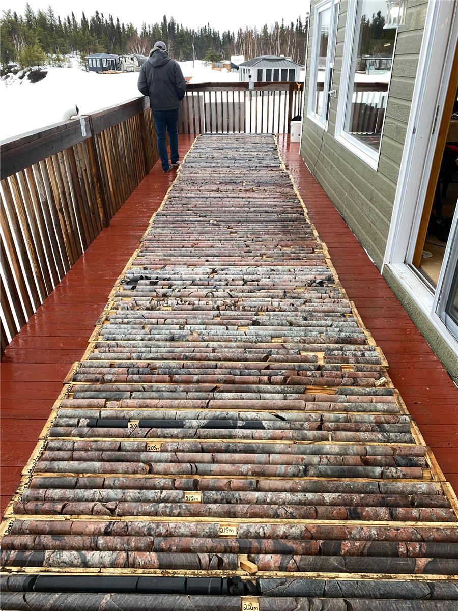
Figure 1: SGN-2026-007 drill core laid out on site showing red-pink granitic pegmatite intervals. The hole intersected 211.25 metres of cumulative pegmatite over 290 metres, including a continuous 105.45-metre interval from 63.85 metres to 169.30 metres.
Please click here to view image
SGN-2026-007 DRILL HOLE SUMMARY
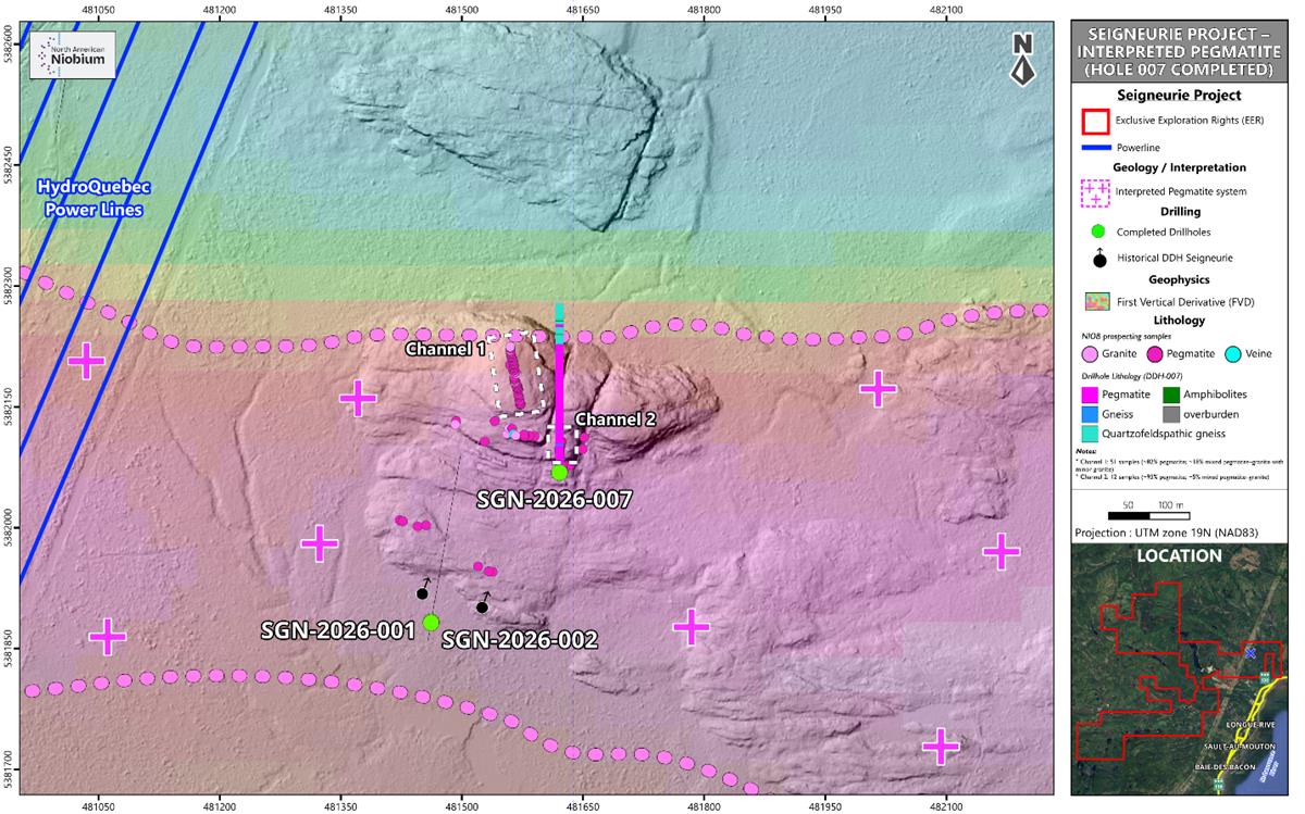
The Seigneurie property lies within Québec’s Grenville Province and is a focus of the Company’s 2026 exploration campaign for niobium-rare earth element-bearing pegmatite systems. SGN-2026-007 is part of a north-south drill fence targeting the Seigneurie pegmatite system at depth (see Figure 4).
SGN-2026-007 Shows Nb-REE Indicators
The intersected pegmatite is a red to pink granitic pegmatite with variable concentrations of smoky quartz and disseminated magnetite.
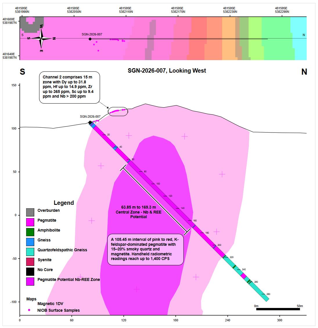
The continuous central zone, a 105.45-metre pegmatite interval from 63.85 to 169.3 metres, is associated with gamma-ray spectrometer peaks (of up to approximately 1,400 counts per second) that have smoky-quartz-rich intervals and titanium-rich magnetite minerals within the main pegmatite. A light-brown mineral observed in direct association with magnetite returned elevated niobium, yttrium, and phosphorus on portable XRF screening; the combined gamma-ray spectrometer response and pXRF are considered by the Company to be encouraging qualitative indicators for potential niobium and rare earth mineralization. Samples have been submitted to the laboratory and assays are pending.
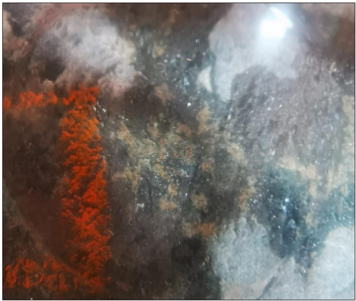
Core logging identified a light-brown mineral assemblage, shown in Figure 3, occurring in close spatial association with titanium-rich magnetite grains. The light-brown mineral assemblage returned notable portable XRF peaks in niobium, yttrium, phosphorus, and zirconium.
Host rocks between pegmatite intervals include biotite gneiss, pink gneiss, and amphibolite. True widths have not yet been determined and will be estimated once the geological model is updated with the remaining drill-hole data.
SGN-2026-007 Points to Potential Indications of Niobium-Rare Earth System at Depth
The strongest surface results reported to date from the Seigneurie project have been associated with radiometric anomalies. Channel 2, previously disclosed as the Company’s best surface channel-sample interval at Seigneurie, returned anomalous dysprosium, hafnium, zirconium, and niobium.
The Company reviewed results from the channel samples and found that the radiometric elements uranium and thorium occur together with niobium and heavy rare earth elements. This suggests that elevated gamma-ray readings may help guide the Company toward prospective niobium-rare earth mineralization at Seigneurie.
Drill hole SGN-2026-007 records sustained elevated radiometric response, together with stronger alteration and higher smoky-quartz–magnetite content than observed at surface in Channel 2. In the Company’s interpretation, these features suggest the hole may be testing a more mineralized part of the system, with potential for higher grades pending laboratory assays.
Portable XRF Disclosure
Portable XRF data referenced in this release were collected with a hand-held instrument on drill core as a logging aid and qualitative screening tool. pXRF readings are indicative only and are not accepted as quantitative results for mineral disclosure purposes. No pXRF concentrations have been published in this news release. Quantitative geochemical results will only be reported following laboratory assay and review against CRM, blank and duplicate quality-assurance data.
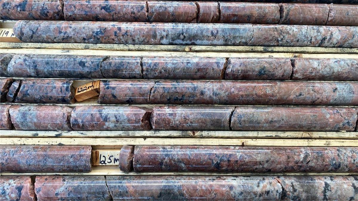
Figure 2: Representative core from the main 105.45 metre pegmatite interval (approximately 122 to 125 metres)—red-pink granitic pegmatite with coarse quartz and Ti-magnetite clusters along with K-Feldspars.
Please click here to view image
Figure 3. Macro (hand-lens) close-up of a polished core face from the main pegmatite interval, showing light brown minerals in direct association with magnetite. Portable XRF screening of this assemblage returned qualitative indications of elevated niobium, yttrium, phosphorus, and zirconium; the light-brown mineral coincides with the strongest gamma-ray spectrometer response logged on core. pXRF indicative only; see pXRF disclosure.
Please click here to view image
Figure 4. Plan view of hole SGN-2026-007. The hole was designed to test the hill where a radiometric anomaly was identified back in the 1970s by SOQUEM. See Figure 5 for cross section of hole SGN-2026-007.
Please click here to view image
Factual Basis for the Comparative Ranking
The Company believes that drill hole SGN-2026-007’s 211.25 m cumulative pegmatite intersection ranks among the longest publicly disclosed drillhole intersections globally for Nb-REE-bearing systems. The metric used is total cumulative downhole length of mineralized host rock intersected within a single drill hole, as reported by the operator in publicly available press releases or technical disclosures. Seigneurie is referred to herein as a pegmatite system with Nb-REE-bearing minerals; no Mineral Resource has been estimated and Seigneurie is not classified as a deposit. The peer set reviewed by the Qualified Person is presented in two tables below: (i) Nb-REE-bearing peers, which include both pegmatite-hosted and alkaline-intrusion-hosted Nb-REE systems and are the geologically and geochemically closest analogues to Seigneurie, and (ii) LCT (lithium-cesium-tantalum) pegmatite projects, shown for additional context across pegmatite deposit types. Only the longest publicly disclosed drillhole intersection per project is shown.
Table 1. Nb-REE-bearing peer projects (pegmatite and alkaline intrusion hosts)
| Project | Operator / Country | Hole ID | Length (m) | Grade | Deposit Type | Source |
| Tanbreez (Hill) | Critical Metals Corp. / Greenland | DX-01 | 338.0 | 0.42% TREO (incl. ~24% HREO) | Kakortokite (alkaline intrusion) | Critical Metals Corp NR, Mar 17, 2025 |
| Norra Kärr | Tasman Metals / Leading Edge Materials / Sweden | NKA 11039 | 264.4 | 0.55% TREO, 1.72% ZrO2 | Peralkaline nepheline syenite (alkaline intrusion) | Tasman Metals NI 43-101 NR, Jan 2012 |
| Seigneurie | NIOB / Quebec, Canada | SGN-2026-007 | 211.25 | Assays pending (2026) | Pegmatite with Nb-REE-bearing minerals | This release |
| Motzfeldt (Aries) | Alba Mineral Resources / Greenland | PSRK-014 | 192.5 | 0.185% Nb2O5, 0.012% Ta2O5, 0.260% TREO, 0.460% ZrO2 | Peralkaline microsyenite (alkaline intrusion) | Alba Mineral Resources RNS, 2024 |
| Two Tom | Rare Earth Metals Inc. / Labrador, Canada | TT-15b | 175.5 | 1.68% TREO, 0.21% Nb2O5, 0.19% BeO | Peralkaline syenite (alkaline intrusion) | Rare Earth Metals NR, Nov 16, 2011 |
| Strange Lake B | Quest Rare Minerals Ltd. / Quebec-Labrador, Canada | BZ11218 | 144.4 | 1.44% TREO | Peralkaline granite (alkaline intrusion) | Quest Rare Minerals NR, Jan 12, 2012 |
| Crater Lake (TG) | Imperial Mining / Scandium Canada / Quebec, Canada | CL22057 | 98.6 | 308 g/t Sc2O3, 0.326% TREO+Y | Ferrosyenite (alkaline intrusion) | Imperial Mining NR, Nov 17, 2022 |
Table 2. LCT pegmatite projects (context)
| Project | Operator / Country | Hole ID | Length (m) | Grade | Deposit Type | Source |
| Cisco | Q2 Metals Corp. / Quebec, Canada | Hole 44 | 457.4 | 1.65% Li2O | LCT pegmatite | Q2 Metals NR, Dec 3, 2025 |
| Manono | AVZ Minerals Ltd. / DRC | MO18DD009 | 341.62 | 1.54% Li2O, 875 ppm Sn | LCT pegmatite | Australian Mining, Jun 28, 2018 |
| Spark | Frontier Lithium Inc. / Ontario, Canada | PL-048-21 | 340.7 | 1.68% Li2O | LCT pegmatite | Frontier Lithium NR, Jun 1, 2021 |
| Seigneurie | NIOB / Quebec, Canada | SGN-2026-007 | 211.25 | Assays pending (2026) | Pegmatite with Nb-REE-bearing minerals | This release |
| Greenbushes | IGO Ltd. / Talison Lithium / Western Australia | CLDD080 | 193.3 | 2.0% Li2O | LCT pegmatite | IGO Greenbushes CY23 R&R, Feb 19, 2024 |
| Corvette CV5 | Patriot Battery Metals Inc. / Quebec, Canada | CV24-704 | 186.0 | 1.08% Li2O (incl. 11.3 m at 4.27%) | LCT pegmatite | Patriot Battery Metals NR, Feb 27, 2025 |
Figure 5: Cross-section of SGN-2026-007 with interpretation of Pegmatite body. See previous Fall 2025 prospecting results (hyperlink)
Please click here to view image
Grant of RSUs
The Company also announces that, pursuant to its stock option and restricted share unit plans, it has granted an aggregate of 200,000 restricted share units to the Chief Executive Officer of the Company, subject to applicable regulatory approval, including approval of the Canadian Securities Exchange. Each RSU entitles the holder to receive one common share of the Company upon vesting. The RSUs vest immediately on the date of grant.
Qualified Person
The scientific and technical information contained in this news release has been prepared in accordance with National Instrument 43-101 – Standards of Disclosure for Mineral Projects. Clyde McMillan, P.Geo., a consultant to the Company and a Qualified Person as defined under NI 43-101, has reviewed and approved the technical information contained herein. Mr. McMillan is non-independent of the Company as an Officer and Shareholder.
Drill hole SGN-2026-007 was drilled at an azimuth of N10 degrees east of true north (N10E) and a dip of 45 degrees inclined to the north. The collar location was verified through three independent measurements: planned position, spotted position prior to drilling, and post-drilling surveyed position. The hole was completed at a total depth of 290 metres.
In support of the radiometric-as-pathfinder interpretation, the Company has reviewed the Pearson correlation structure among 11 key pathfinder, radiometric and REE-group elements across the 12 Channel 2 surface assay samples (ALS method ME-MS71L; see Figure 6). The analysis shows that niobium is strongly correlated with uranium (r = 0.96), thorium (r = 0.81) and the heavy rare earth elements dysprosium (r = 0.80) and terbium (r = 0.81). Thorium is in turn very strongly correlated with the heavy rare earth elements (Th-Dy = 0.94, Th-Tb = 0.93). Zirconium and hafnium track each other almost perfectly (r = 0.99). In the Company’s interpretation, this co-variation provides direct quantitative support for the gamma-ray spectrometer response observed on core in SGN-2026-007 representing a robust pathfinder for Nb and HREE mineralization at Seigneurie.
Portable XRF analyses referenced in this release were collected using an Evident Vanta MAX/CORE handheld analyzer in GeoChem 3-Beam mode on spot measurements taken on representative drill core during logging. The instrument was rented from Geospectra Mining Technologies and was supplied with a calibration certificate confirming factory calibration prior to deployment. All measurements were performed by a certified pXRF operator. On-site quality control included periodic measurements of certified reference materials (CRMs) and instrument blanks throughout the program to monitor analytical performance and detect any drift. No pXRF values are reported in this release. Because pXRF measurements are semi-quantitative, the analyzer was used solely to confirm the presence of target elements and associated mineralization during core logging.
Gamma-ray spectrometer responses logged on SGN-2026-007 are spatially consistent with historical radiometric measurements collected by SOQUEM in 1977 over the same prospect (Quebec MERN open-file report GM 34527, ‘Campagne de Forage, Anomalie C11R10, Projet 22-3023’). The 1977 work identified the Seigneurie radiometric anomaly that was subsequently targeted by the Comapny’s 2026 drill program. The fact that the present-day hand-held gamma-ray spectrometer readings reproduce the location and intensity of the 1977 historical response provides an independent cross-validation of the radiometric anomaly that SGN-2026-007 was designed to test.
The mineralogical identifications referenced in this news release are based on visual core logging and portable XRF screening only; no laboratory assay results are yet available for the intervals reported. Samples have been submitted to an accredited laboratory. Geochemical results – including any quantitative niobium, rare earth element, yttrium, phosphorus, zirconium or other metal content – will be reported when assays are received and quality-assurance review is complete. Radiometric readings on core were collected with a hand-held gamma-ray spectrometer as a qualitative logging aid and are not a substitute for laboratory assay. Portable XRF readings are indicative only and are not reported as quantitative results in this news release.
The statement that drill hole SGN-2026-007 ranks among the top five longest publicly disclosed Nb-REE-bearing pegmatite drillhole intersections globally is based on the Qualified Person’s review of press releases and technical disclosures from comparable projects, including Motzfeldt (Aries prospect, Greenland; Ram Resources Ltd., longest disclosed intersection PSRK-014 at 192.5 m), Strange Lake B-Zone (Quebec / Labrador, Canada; Quest Rare Minerals Ltd., longest disclosed pegmatite-style intersection BZ11218 at 144.4 m), Tanbreez (Greenland; Critical Metals Corp., layered nepheline syenite host) and Norra Kärr (Sweden; Tasman Metals Ltd. / Leading Edge Materials Corp., agpaitic nepheline syenite host). Where intersections are hosted in peralkaline granite, nepheline syenite or other intrusion-style hosts rather than classic Nb-REE-bearing pegmatite, these have been considered as broader benchmarks rather than direct pegmatite peers. The Qualified Person has reviewed the drill logs, core photographs, gamma-ray spectrometer data, portable XRF screening data and field records for SGN-2026-007 and has verified the intervals reported herein. Laboratory assays for SGN-2026-007 are pending as of the date of this release. Portable XRF results are indicative only, are subject to matrix and calibration limitations, and are not a substitute for laboratory analysis.
ABOUT NORTH AMERICAN NIOBIUM AND CRITICAL MINERALS CORP.
North American Niobium and Critical Minerals Corp. is a North American mineral exploration company focused on the acquisition and development of precious, base, and critical mineral assets. Its portfolio includes the Silver Lake property in British Columbia’s Omineca Mining Division and a district-scale land package covering 29,936 hectares in Quebec’s Grenville Province. The Quebec properties host rare earth element, niobium, and nickel-copper occurrences, expanding the Company’s footprint into critical minerals that are strategically important for energy and defense applications.
ON BEHALF OF THE BOARD OF DIRECTORS:
Murray Nye
Chief Executive Officer
info@northamericanniobium.com
+1 (647) 984-4204
Brutus Mining Inc. (CSE: BRU) (FSE: ZI3) is pleased to announce that it has closed its non-brokered ... READ MORE
Jaguar Uranium Corp. (NYSE American: JAGU) is pleased to announce an independent Mineral Resource E... READ MORE
Auro Metals Inc. (TSX-V: AURO) (OTCQB: AURFF), is pleased to announce the assay results of the fina... READ MORE
Endeavour Silver Corp. (NYSE: EXK) (TSX: EDR) is pleased to announce that repairs to the primary bal... READ MORE
Scorpio Gold Corp. (NASDAQ: SGLD) (TSX-V: SGLD) (OTCQB: SRCRF) (FSE: RY9) is pleased to announce re... READ MORE


