


WPC-35: 5.9m grading 38 g/t (1.2 oz/T) Silver (“Ag”) and 12.1% Zinc (“Zn”) Including 3.2m grading 67 g/t (2.1 oz/T) Ag and 16.9% Zn
SS25-04: 4.4m grading 148 g/t (4.6 oz/T) Ag; 0.68% lead (“Pb”) and 0.24% Zn Including 1 m grading 349g/t (10.8 oz/T) Ag 2.2% Pb and 0.20% Zn
Alaska Silver Corp. (TSX-V: WAM) (OTCQX: WAMFF) is pleased to report high-grade silver and zinc results in several holes from its limited 2025 drilling program (<3000m) at the 100%-owned Illinois Creek Carbonate Replacement Deposit project in western Alaska. The 2025 program comprised 2,057 m of drilling in 4 holes at the Waterpump Creek deposit, with WPC-35 which cut 5.9m (core length) grading 38 g/t (1.2 oz/T) Ag and 12.1% Zn, including 3.2m grading 67 g/t (2.1 oz/T) Ag and 16.9% Zn. In addition, 906.5 m of drilling in 9 shallow scout holes was completed at the newly discovered high-grade silver-lead zone, Silver Sage, located approximately 4.8km south of Waterpump Creek (See press release dated November 3, 2025). Among these holes, SS25-04 cut 4.4m (core length) reporting 148 g/t (4.8 oz/T) Ag; 0.68% Pb and 0.24% Zn, including 1 m grading 349g/t (11.2 oz/T) Ag 2.2% Pb and 0.20% Zn.
“With the discovery of the blind, high-grade Silver Sage zone and refinement of the architecture of Waterpump Creek South, we feel we had a highly successful season despite having a very limited budget. We think we are zeroing in on the link to the southern extension of our Waterpump Creek resource and want to emphasize the importance of the blind Silver Sage zone, not just in how it expands the Illinois Creek district footprint, but how it indicates that more such mineralized zones are likely hidden beneath our extensive cover, “ said Kit Marrs, Alaska Silver’s President and CEO. “Having completed our US listing and $13.8 million dollar financing after the 2025 field season, we are well poised to put those resources to work through much more aggressive drilling in 2026.”
2025 Waterpump Creek Drilling
Alaska Silver completed a limited 4-hole, 2,057m drilling program at the Waterpump Creek to seek extensions of the known high-grade resource, which contains 75 million ounces AgEq at a grade of 279 g/t silver, 11.28 % zinc and 9.87% lead (see press release of February 22, 2024 and disclosures at the end of this release), across a post-mineral fault zone and to identify the structural conduits that channeled mineralizing fluids into carbonate-rock mineralization traps. Two of the four holes hit significant silverzinc mineralization (See Tables 1 and 2) north of the fault and probably represent the continuation of the high-grade Waterpump Creek resource. The other two holes deviated significantly from their targets, but one hole (WPC25-0037) cut appreciable copper and both cut extensive CRD-style mineralization. The copper here may indicate proximity to a feeder structure. All four holes cut post-mineral faults and provide critical information on the overall architecture of the Waterpump Creek area. The combined results strongly indicate that mineralization continues to the south of the post-mineral fault, and the improved understanding of how the post-mineral faulting created the current deposit geometry will help guide comprehensive step-out drilling to successfully locate the offset mineralization.
Silver Sage Discovery
In early July 2025, Alaska Silver identified a new mineralized zone, Silver Sage, through initial trenching along a 1.5 km long transect centered on historical 1980s soil anomalies that had never been followed up on (See press release of November 3, 2025). The program quickly identified a 550m long deeply weathered breccia zone containing distinctive rubbly boulders of massive silver-bearing galena and cerussite (oxidized galena). Trench sampling returned numerous high-grade silver-lead values, including multiple samples reporting assays above 310 g/t silver (10 oz/T), with grades up to 1,235 g/t silver (40 oz/T) (See Fig. 1). Sampling also returned gold values as high as 0.55 g/t.
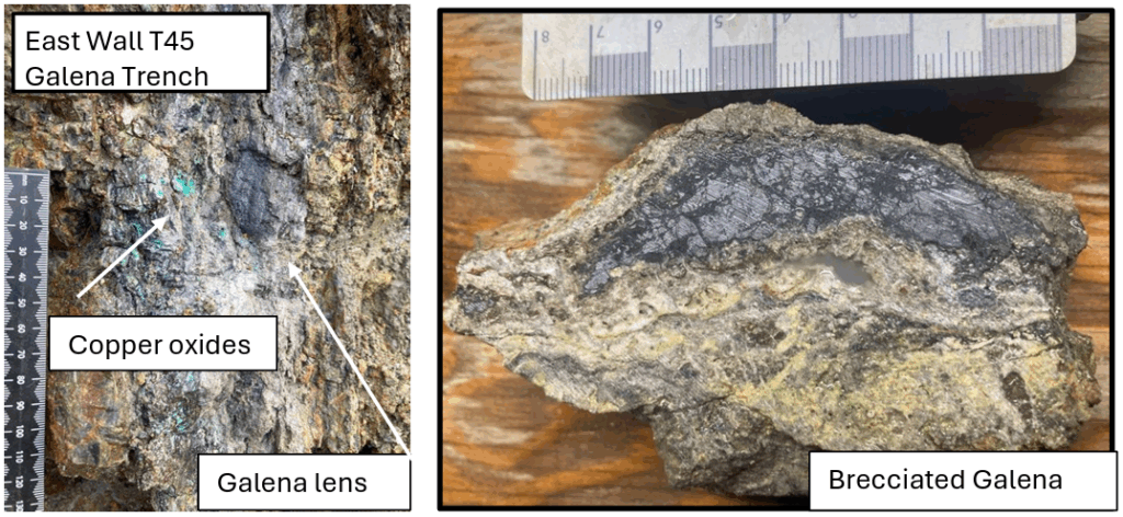
Figure 1. Galena Trench: Brecciated argentiferous galena with copper oxides and yellow-green finegrained mineral in banded siliceous rock
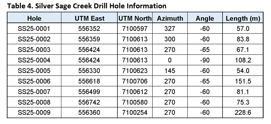
Late in the season, nine short, widely spaced drill holes totaling 906.5 m were drilled across and along the inferred axis of the breccia zone to evaluate stratigraphy, alteration, and potential structural controls. Four of the holes hit significant localized silver and lead with widespread anomalous zinc values and gold locally exceeding 1 g/t and copper approaching 1% (See Tables 3 and 4). The mineralization was deeply oxidized with geochemistry indicating the dissolution and removal of a substantial proportion of the zinc. The drilling shows that the mineralization is concentrated at the top of a thick section of reactive carbonate rocks directly beneath an impermeable schist layer – a classic CRD setting. Follow-up drilling of the area to locate the feeder for this mineralization and coherent mineralization is a priority goal for the 2026 field season.
2025 Waterpump Creek Drilling Program
Alaska Silver has delineated a significant high-grade Ag-Pb-Zn Inferred Resource at Waterpump Creek (See Press Release of February 22, 2024). Believed to be part of much more extensive integrated CRD mineralization system, the resource ends abruptly against a post-mineral fault, so the Company’s focus for 2025 has been to find the offset continuation of the deposit to the south across this fault. During the 2025 field season, Alaska Silver completed a limited drilling program of four holes totaling 2,057 metres in an initial attempt to locate this continuation (Fig. 2). Two holes (WPC-35 and 36) were designed to refine the location of the post mineral fault and continue to depth to seek extensions to the Waterpump Creek resource itself. Both succeeded, first cutting the fault and then significant silver and high-grade zinc mineralization (See Table 1). The second two holes were designed to determine the direction of offset on the post mineral fault, but both deviated significantly from their targets. Nonetheless, both cut significant CRD-style alteration and one (Hole WPC25-0037) cut appreciable copper, which may indicate proximity to a feeder structure. In combination, the 4 holes demonstrate continuation of the favorable reactive carbonate host stratigraphy and that mineralizing fluids affected the south block. The drilling also identified at least 2 strands of post-mineral faults, providing important information on the current structural architecture of the Waterpump Creek area and improved understanding of the post-mineral faulting.
The two holes completed south of the post-mineral 4700N fault (WPC25-0034 and WPC25-0037) both intersected the schist–carbonate contact at about 500 metres depth and showed moderate to weak CRDstyle alteration. The alteration was stronger in WPC25-0034 than WPC25-0037 suggesting the mineralized zone lies to the west and indicating the 4700N fault has both vertical and lateral movement. This defines potential targets to the west of WPC25-0034 for drilling in 2026. In contrast, holes WPC25-0035 and WPC25-0036 drilled north of the fault confirmed the continuation of the mineralization and alteration patterns of the known Waterpump Creek deposit. Hole WPC25-0036 returned 1.23 metres of 107 g/t silver and 17% zinc surrounded by strong, characteristic CRD-style alteration with elevated geochemistry. This hole is interpreted to have narrowly missed the continuation of the principal mineralized body.
Aggressive drilling is planned for 2026 to better understand the structure, locate mineralization in the south block and follow that mineralization back towards its source.
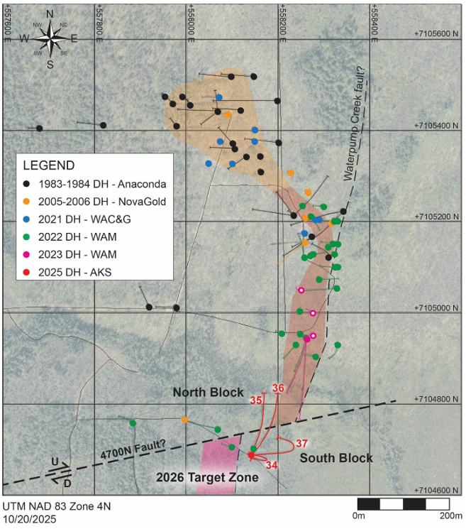
Figure 2. Map of the Waterpump Creek area with 2025 drill hole traces illustrated in red.
2025 Silver Sage Drilling Program
In addition to the discovery trenching and fieldwork, 9 shallow “Scout” holes totaling 906.5 meters were drilled at Silver Sage to get a preliminary idea of the area’s geological framework (See Fig. 3 below). The first 8 holes had an average depth of 100m, and with the exception of Hole SS25-0006, were drilled along an east-west section to determine stratigraphy and if a feeder structure could be defined. Hole SS25-0006 was drilled 120m north of this line and Hole SS25-0009, the deepest hole (228m), was drilled 500m to the south to test a CSAMT anomaly. The drilling shows that the mineralized carbonate package is about 100m thick and is sandwiched between an overlying schist package that crops out to the east and an underlying greenstone unit that appears on the west. The strongest hydrothermal activity is concentrated along the upper carbonate contact just below the capping schist unit but also affects a series of layers in the basal part of the schist. This contact zone hosts the deeply weathered breccia with fragments of massive highgrade argentiferous galena that led to the discovery in Trench T45, the “Discovery” or “Galena” trench. In the drillholes that cut this contact (Holes S25-005 and S25-008 respectively, were drilled below and above it), this contact is marked by heavily sanded, muddy gossans that range in color from nearly black to rusty orange. The darker gossans are very rich in manganese (to 10%). All of the gossan zones returned strong gold, silver, copper, lead, zinc and manganese values along with a basket of trace elements. Zinc values are low because the intense weathering dissolved the zinc minerals and “flushed out” the zinc.
“The concentration of hydrothermal activity at the top of a favorable reactive carbonate, immediately below an impermeable “seal” is a hallmark feature of distal CRDs and in many instances mineralizing fluids are known to have traveled many hundreds of meters from their source feeder along this type of contact,” said Peter Megaw, Ph.D., Alaska Silver’s Technical Advisor. Furthermore, Dr. Megaw stated, “Locating this feeder is an important early exploration goal but the drilling done to date at Silver Sage is so shallow that structural determinations are nearly impossible because the rocks in the upper parts of all holes drilled through the breccia and gossan zones were highly broken and jumbled. Nonetheless, the location and composition of the higher-grade oxidized mineralization gives some initial clues that will be used to guide 2026 drill targeting (See Fig 4 below).”
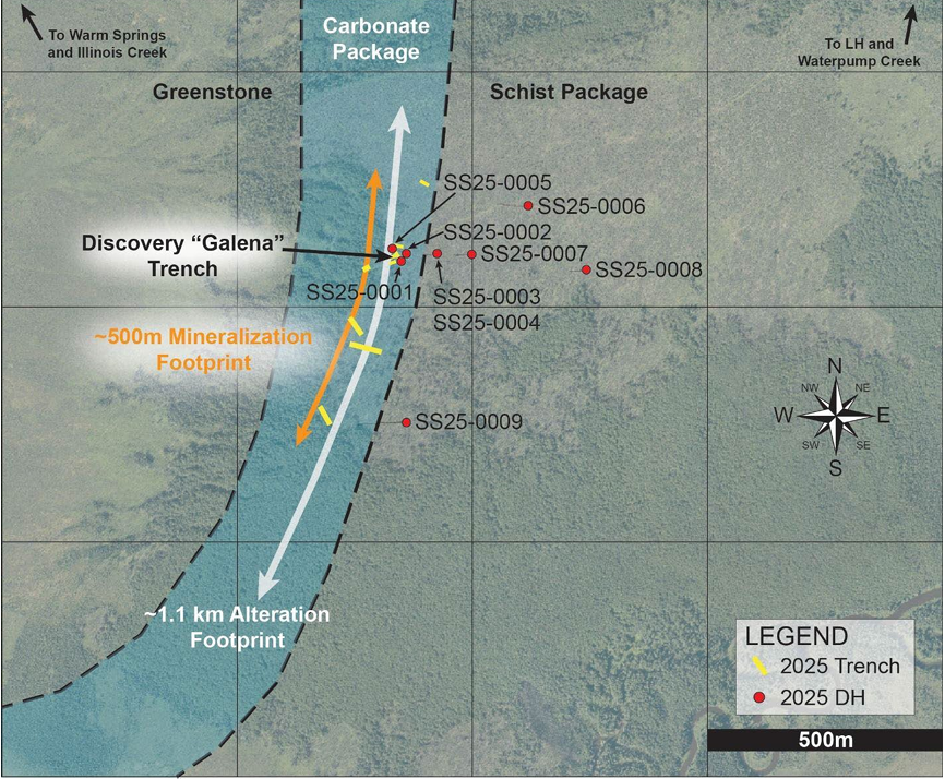
| Figure 3. Map of the Silver Sage zone showing trench locations, drill hole collars, and generalized geology. |
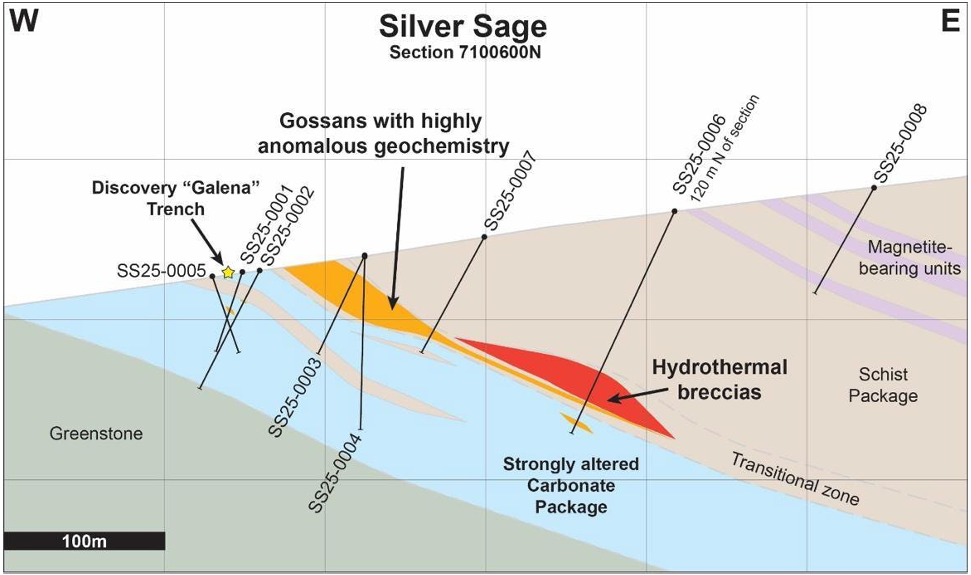
Figure 4. East-west cross section on line 7100600N at Silver Sage showing geologic units and mineralized zones.
The Company believes that the most important drillholes are SS25-0001, 0003 and 0004, each of which cut strong gossans with good values (See Table 3).
SS25-0001
Collared approximately 15m southeast of the Galena Trench (T45), this hole was aimed directly at the projection of the galena zone exposed in the trench. The hole mostly cut highly altered and weathered dolostone interlayered with schist. Much of the core was highly sanded or brittle and tended to crumble quickly. A strong gossan package was cut between 27.0 and 30.1 meters, which reported 0.43 g/t gold and 61.9 g/t silver, including 0.4 meters with 1.97 g/t gold, 2,221 g/t silver and 0.94% copper.
SS25-0003
Collared approximately 85m east of SS25-0001, this hole targeted the main schist-carbonate contact downdip from the previous two holes. Most of the hole was in highly sanded interlayered schist and dolostone and drilling was difficult. However, along and below the schist and dolostone contact multiple, parallel gossan zones were cut carrying high iron, manganese and silver, with modest gold values. The most significant intercept was 6.7 meters (core length) from 25.2 meters that contained 55.7 g/t silver, with an internal high-grade zone 0.8 meters thick carrying 0.37g/t gold and 136 g/t silver.
SS25-0004
Hole SS25-0004 is the best hole drilled at Silver Sage to date. Drilled off the same pad as SS25-0003, it was designed to cut the same gossans at greater depth. Drilling conditions were equally poor due to pervasive sanding and weathering. Overall lithologies were similar to SS25-0003 and, like SS25-0003, the extreme disruptions prevented structural determinations. Two principal gossan zones were cut. The first was a 4.4meter zone (core length) from 14.8 meters depth containing 0.17 g/t gold, 148 g/t silver and 0.68% lead, within which the uppermost 1 meter ran 0.60 g/t gold, 349 g/t silver, 0.15% copper and 2.20% lead. The second gossan interval was a broad, multi-layer zone with a combined thickness of 17.9 meters (core length) beginning at 26.4m downhole, that averaged 11.5 g/t silver and just over 1% zinc. Within this at 28 m depth, was a 1-meter interval that ran 96.5 g/t silver and 1.24% Zn.
|
|
|
Hudbay Minerals Inc. (TSX:HBM) (NYSE: HBM) today released its ann... READ MORE
Strategic acquisition of an established operating gold mine, loca... READ MORE
Cerro de Pasco Resources Inc. (TSX-V: CDPR) (OTCQB: GPPRF) (FRA: ... READ MORE
The Garneau Titanium Project Features Ilmenite-Rich Boulder with ... READ MORE
ValOre Metals Corp. (TSX‐V: VO) (OTCQB: KVLQF) (Frankfurt: KEQ0... READ MORE


