








The Prospector News

Lithium Ionic drills high-grade 1.69% Li₂O over 9.6m, 1.27% Li₂O over 10m and 1.61% Li₂O over 4.7m at its Bandeira target, Minas Gerais, Brazil

You have opened a direct link to the current edition PDF

Open PDF Close
Uncategorized

Share this news article

Lithium Ionic drills high-grade 1.69% Li₂O over 9.6m, 1.27% Li₂O over 10m and 1.61% Li₂O over 4.7m at its Bandeira target, Minas Gerais, Brazil


Lithium Ionic Corp. (TSX-V: LTH) (OTCQB: LTHCF) (FRA: H3N) reports assay results from an ongoing drilling program at its 100%-owned Bandeira property, located in the state of Minas Gerais, Brazil. Bandeira is located approximately 500 metres South of Companhia Brasileira de Lítio’s Cachoeira mine, which has been producing lithium since 1993, and approximately 700 metres North of Sigma Lithium’s Barreiro lithium deposit, forming part of the largest hard rock lithium deposit in the Americas (See Figure 1).


Bandeira Results Highlights

  • 1.59% Li₂O over 9.62m, incl. 2.39 Li₂O over 5m (hole ITDD-22-039)
  • 1.27% Li₂O over 10.09m, incl. 2.13% Li₂O over 5.06m (hole ITDD-22-023)
  • 1.61% Li₂O over 4.72m and 2.43% Li₂O over 1.40m (hole ITDD-22-038)
  • 1.95% Li₂O over 1.60m within 0.78% Li₂O over 8.90m (hole ITDD-22-032)
  • 1.43% Li₂O over 1.28 and 1.28% Li₂O over 4.88m (hole ITDD-22-035)
  • 1.43% Li₂O over 4.36m (hole ITDD-22-043)
  • 1.34% Li₂O over 2m (hole ITDD-22-036)
  • 1.42% Li₂O over 3.31m (hole ITDD-22-045)


Blake Hylands, Chief Executive Officer of Lithium Ionic, commented, “Results from Bandeira continue to impress us, with latest intercepts returning some of the strongest grades and thicknesses encountered to date at this target. We have now identified an over 1km mineralized trend with at least six different spodumene-bearing pegmatite bodies which remain open in all directions. We continue to aggressively drill Bandeira as we work towards delivering our maiden mineral resource estimate in the coming months.”


To date, Lithium Ionic has completed over 11,000 metres (95 drill holes) of a planned 30,000-metres drill program, focused primarily on its Bandeira and Galvani targets. Approximately 5,800 metres (51 drillholes) have been drilled at Bandeira, while approximately 5,600 metres have been drilled at Galvani (44 drillholes). The drill campaign at Bandeira was designed to target near-surface mineralization associated with several lithium soil anomalies covering a ~1.3 km trend, which were identified in early 2022.


To date, the Company has identified at least six different NE-SW trending lithium-bearing LCT pegmatites. These mineralized bodies range from 1 to 10 meters in width and can be traced over a 1km strike length. The average depth of the lithium zones drilled to date is approximately 150 metres, however the Company has intersected strong lithium grades and thicknesses up to 300 metres below surface. The style of mineralization found to date, characterized by several stacked pegmatite vein sets are consistent with other nearby lithium deposits.


The strong values announced today have confirmed new near-surface zones of mineralization, such as hole ITDD-22-023 which intersected 1.27% Li₂O over 10.09 metres within 25m from surface (see Figure 2) and have also confirmed high-grade depth extensions of previous trench and drill results, such as holes ITDD-22-032 and ITDD-22-039 intersecting up to 1.59% Li₂O over 9.62m and 1.95% Li₂O over 1.60m (see Figure 3).


Previously announced drill highlights from Bandeira include:

  • 1.44% Li₂O over 8.33m (hole ITDD-22-012)
  • 1.99% Li₂O over 6.75m (hole ITDD-22-011)
  • 1.93% Li₂O over 5.66m (hole ITDD-22-002)
  • 1.49% Li₂O over 6.7m (hole ITDD-22-030)
  • 2.22% Li₂O over 3.7m (hole ITDD-22-025)
  • 1.97% Li₂O over 3.7m (hole ITDD-22-019)
  • 1.55% Li₂O over 5.2m (hole ITDD-22-001)
  • 1.56% Li₂O over 3.90m and 1.66 Li₂O over 2.76 (hole ITDD-22-013)
  • 1.22% Li₂O over 9.2m, incl. 1.71% Li₂O over 5.7m; and 2.46% Li₂O over 2m (hole ITDD-22-024)


The Company recently mobilized a sixth drill rig and continues to aggressively explore, with four rigs at Bandeira and two at Galvani as it works towards completing a maiden NI 43-101 mineral resource estimate in the coming months.
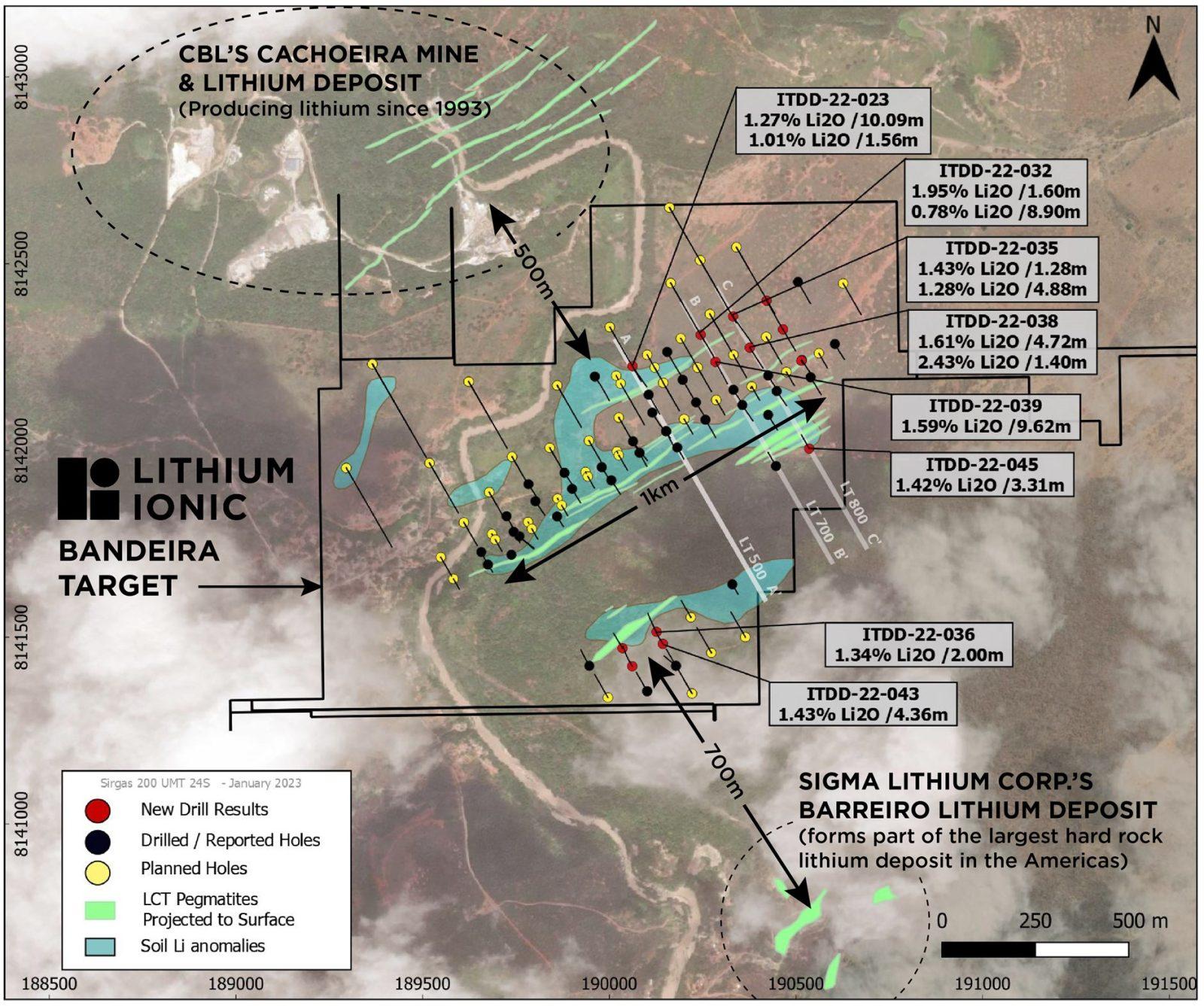
Figure 1: Bandeira Drill Highlights, Section Locations & Nearby Lithium Deposits
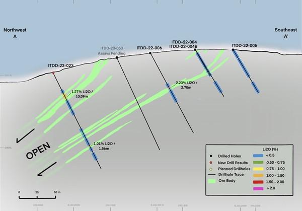
 

 Figure 2: Section LT500 Facing North-East
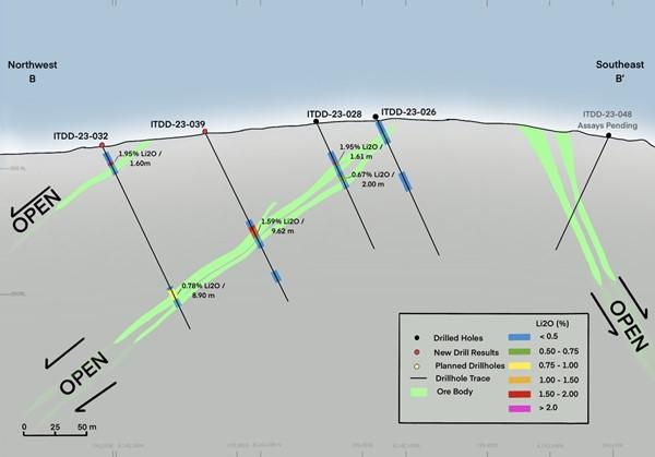
 Figure 3: Section LT700 Facing North-East
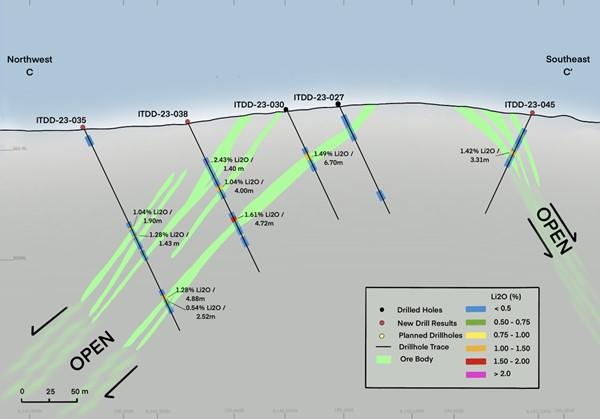
 

 Figure 4: Section LT800 Facing North-East


 Figure 5: Lithium Ionic Claims Totalling ~3,600 ha Overlaid on Geology Map


Table 1. Bandeira Drill Results


Hole ID Az Dip From To Metres LiO (%)
ITDD-22-023 150 -65 33.5 43.59 10.09 1.27
incl.     38.53 43.59 5.06 2.13
and     114.34 115.9 1.56 1.01
ITDD-22-032 150 -65 18.35 19.95 1.60 1.95
and     130.30 139.20 8.90 0.78
ITDD-22-033A 150 -65 6.05 8.05 2.00 0.50
ITDD-22-034 330 -65 17.42 21.10 3.68 0.52
incl.     17.42 18.42 1.00 1.17
ITDD-22-035 150 -65 103.27 105.17 1.90 1.04
and     111.93 113.21 1.28 1.43
and     171.62 176.50 4.88 1.28
and     178.50 181.02 2.52 0.54
ITDD-22-036 330 -65 39.10 45.10 6.00 0.90
incl.     42.10 44.10 2.00 1.34
ITDD-22-038 150 -65 43.26 44.66 1.40 2.43
and     67.32 71.32 4.00 1.04
incl.     67.32 69.32 2.00 1.28
and     98.13 102.85 4.72 1.61
ITDD-22-039 150 -65 86.24 95.86 9.62 1.59
incl     86.24 91.24 5.00 2.39
ITDD-22-040 330 -65 55.90 56.90 1.00 1.36
ITDD-22-041 150 -65 37.16 37.97 0.81 0.60
ITDD-22-043 330 -65 38.05 42.41 4.36 1.43
ITDD-22-044 150 -65 NSV
ITDD-22-045 330 -65 41.57 44.88 3.31 1.42


About Lithium Ionic Corp.


Lithium Ionic is a Canadian-based lithium-focused mining company with properties covering ~3,600 hectares located in the prolific Aracuai lithium province in Minas Gerais State, Brazil, which boasts excellent infrastructure, including highways, access to hydroelectrical grid power, water, and nearby commercial ports. Its Itinga and Galvani claims are located in the same district as the lithium-producing CBL mine and construction-stage Sigma Lithium Corp.’s large Barreiro and Xuxa lithium deposits.


Quality Assurance and Control


During the drill program, assay samples were taken from NQ core and sawed in half. One-half was sent for assaying at SGS Laboratory, a certified independent commercial laboratory, and the other half was retained for results, cross checks, and future reference. A strict QA/QC program was applied to all samples. Every sample was processed with Drying, crushing from 75% to 3 mm, homogenization, quartering in Jones, spraying 250 to 300 g of sample in steel mill 95% to 150. SGS laboratory carried out multi-element analysis for ICP90A analysis.


Qualified Persons


The technical information in this news release has been prepared by Carlos Costa, Vice President Exploration of Lithium Ionic and Blake Hylands, CEO and director of Lithium Ionic, and both are “qualified persons” as defined in NI 43-101.


Posted January 24, 2023

Share this news article

MORE or "UNCATEGORIZED"


Critical Metals Corp Achieves Breakthrough Tanbreez Heavy Rare Earth Results: >99% Dissolution of Eudialyte Concentrate Into 19 Ultra-High-Purity Rare Earth Products; Refinery Study Projects US$1.8–2.2b in Annual Refinery Revenue

Critical Metals Corp. (Nasdaq: CRML) a leading critical minerals ... READ MORE

September 16, 2026

Metalsource Mining Extends High Grade Mineralization at Depth as Silver Hill Exploration Enters Major Expansion Phase

Holes SH26-22 and SH26-23 return up to 930 g/t AgEq within broade... READ MORE

September 16, 2026

Pasinex Completes Sale of High-Grade Zinc Sulphide Material and Provides Pinargozu Operations Update

Pasinex Resources Limited (CSE: PSE) (FSE: PNX) a growing zinc-fo... READ MORE

September 16, 2026

Aya Gold & Silver Reports High-Grade Silver Exploration Results Near Pit and at Depth at Zgounder

Aya Gold & Silver Inc. (TSX: AYA; NASDAQ: AYA) is pleased to... READ MORE

September 16, 2026

New Break Resources Ltd. (CSE: NBRK) (OTCQB: NBRKF) (FSE: O91) has received results from the last four holes of a ten-hole, 1,996 metre summer drilling program in the Zavitz gold zone at the Company's 100% owned Moray gold project. In total, New Break has completed 5,372 metres of drilling in 32 drillholes in 2026. Moray is located 49 km southeast of Timmins, Ontario and 32 km northwest of the Young-Davidson gold mine operated by Alamos Gold Inc. Select results from the final four of ten holes drilled in the summer drilling program are presented below in Table 1, while drillhole collar locations are detailed in Table 2 in Appendix A. Table 1 – Moray Summer 2026 Final Drill Results Hole ID Length (m) From (m) To (m) Width (1) (m) Au Grade (2) (g/t) NBR-26-29 322.0 77.3 78.8 1.5 0.42 and 138.0 139.1 1.1 0.38 and 162.5 173.3 10.8 (3) 1.61 and 227.4 229.0 1.6 1.21 and 231.5 232.1 0.6 1.72 NBR-26-30 250.0 37.0 38.0 1.0 0.30 and 102.8 103.5 0.7 0.60 and 121.5 122.5 1.0 0.36 and 124.5 125.5 1.0 0.33 and 128.5 129.0 0.5 0.90 and 131.0 132.0 1.0 0.36 and 169.8 174.0 4.2 2.65 and 178.0 179.5 1.5 0.77 and 183.5 186.6 3.1 1.22 and 190.0 190.5 0.5 1.06 and 191.5 192.5 1.0 1.48 and 196.0 200.5 4.5 2.53 and 203.5 204.0 0.5 2.15 and 206.5 212.0 5.5 1.57 NBR-26-31 274.0 169.0 170.5 1.5 0.37 and 184.5 186.0 1.5 0.51 and 197.0 200.0 3.0 0.94 and 201.5 202.0 0.5 0.50 and 203.5 210.0 6.5 (3) 3.12 NBR-26-32 352.0 73.5 74.0 0.5 0.44 and 174.0 174.6 0.6 0.52 and 194.0 195.0 1.0 0.66 and 199.8 203.3 3.5 2.29 and 227.3 228.0 0.7 0.97 (1) Intervals are drill intersections and do not necessarily represent true widths. (2) All intervals are presented using a cut-off grade of 0.3 g/t Au and internal dilution of no more than 1.0 metres at grades less than 0.3 g/t Au and assays are not capped (see QA/QC Procedures). (3) Drill core photos shown in Appendix B. Figure 1 – Newly Reported Drillholes NBR-26-29, 30 Figure 2 – Newly Reported Drillholes NBR-26-30, 31, 32 Note: The bottom of NBR-26-30 deviated southeast and is represented in both sections. Figure 1: Section B-B1 incorporates drillholes NBR-26-06, 07, 08, 25, 26, 27, 28, 29 and part of 30. Gold mineralization extends southeast into the syenite as exhibited in NBR-26-29. NBR-26-30 is identified in both sections A-A1 and B-B1 as the drillhole was collared along section A-A1 but deviated southeast, intersecting gold mineralization in the mafic volcanics in section B-B1. Figure 2: A-A1 incorporates drillholes NBR-26-03, 04, 05, 23, 24, 30, 31 and 32. NBR-26-31 exhibits gold mineralization both within the syenite (at the contact) and within a "flow breccia" within the hematite altered mafic volcanic at the contact. NBR-26-32 is typified by blocky faulted ground with lamprophyre dykes and gold mineralization in the hematite altered mafic volcanics in a brecciated quartz vein with angular syenitic fragments. William Love, Chief Executive Officer of New Break commented, "Ongoing drilling this summer in the Zavitz gold zone continues to deliver significant gold values, with gold mineralization intercepted in every drillhole. As depicted in Figures 1 and 2, gold mineralization has been encountered predominantly within the mafic volcanics. Importantly, drillholes NR-26-29 and NR-26-32, the deepest drilled to date, demonstrate that gold mineralization extends into the syenite to the southeast at the contact with the mafic volcanics." He further noted, "The intrusive-mafic volcanic contact in the Zavitz gold zone has a distinctive magnetic high. This could be reflective of the higher proportion of iron in these mafic volcanics, which is associated with the higher gold values. This same magnetic and IP signature has been identified elsewhere in areas also believed to be along the intrusive-mafic volcanic contact. Drilling these never before tested targets with the goal of identifying gold mineralization similar to that encountered in the Zavitz zone represents the potential for significantly expanding the Moray gold discovery. There is also the belief that the Zavitz zone could represent the first of a series of stacked mineralized gold zones, which would point to the potential for a much larger gold system at depth. We plan to test this through deeper drilling directly into the Zavitz zone." About the Moray Gold Project The Moray property is located in the heart of the Ontario Abitibi greenstone belt, 49 km southeast of Timmins surrounded by a number of significant gold producing companies and existing mills (see Figure 3). The Young-Davidson gold mine operated by Alamos Gold Inc., with its 8,000 tonne per day mill is the closest and within a short trucking distance of approximately 45 km by road from Moray. The understanding of gold mineralization at Moray continues to evolve with each round of drilling. The occurrence of gold mineralization extending into the syenite to the southeast of the Zavitz zone and in the deepest drillholes is noteworthy given the presence of syenite-hosted mineralization at Young-Davidison. More recent examination of the drill core also suggests that the gold mineralization discovered to date may resemble an intrusion related style of deposit like Agnico Eagle's Upper Beaver gold deposit east of Kirkland Lake, as opposed to a structurally hosted gold system. Both Young-Davidson and Upper Beaver host multi-million ounce gold deposits. Figure 3 – Moray Location Map: Surrounding Gold Producers and Upper Beaver Gold Project Technical Content and Qualified Person The scientific and technical information contained in this news release has been reviewed and approved by Peter C. Hubacheck, P. Geo, consulting geologist to New Break, and an independent Qualified Person as defined by National Instrument 43-101. Mr. Hubacheck certifies that this news release fairly and accurately reflects the technical information and data presented. New Break conducts its exploration activities in accordance with CIM Best Practices Guidelines. QA/QC Procedures QA/QC procedures were executed to ensure all work is conducted in accordance with best practices. All drill core was sawn in half with one half of the core prepared for shipment and the other half retained for future verification. All core is under watch from the drill site to the core processing facility. Drill core is BQTK size and sample intervals range from 0.5 metres to 1.0 metres in length. Commercially prepared certified reference material ("CRM") standards and blanks were inserted with each shipment at a rate of 1 QAQC sample in every 12 core samples. Samples from New Break's 2026 Moray drilling program were analyzed at Activation Laboratories in Timmins, Ontario, which is ISO 17025 certified, by 30-gram fire assay with atomic absorption finish. Any sample assaying greater than 10.0 g/t Au was re-assayed with fire assay gravimetric analysis. Grade composite intervals over core lengths are calculated using a weighted average grade with a cut-off grade of 0.3 g/t Au. Up to 1.0 m of internal dilution (consecutive interval below cut-off grade) are included within specific geologic domains and alteration assemblages, except as otherwise noted. The composites are constrained geologically by metasomatic alteration processes sourcing from the Fiset syenite intrusion and contact mafic volcanic rocks. Elevated gold values are coincident with hematite, silica, sericite and pyrite mineralization within structurally prepared brecciated corridors flanking the intrusion. Intervals are not true widths and no top cutting has been applied to the higher gold values. About New Break Resources Ltd. New Break is a Canadian mineral exploration company focused on its Moray gold project located 49 km southeast of Timmins, Ontario, in a well-established mining camp within proximity to existing infrastructure, and 32 km northwest of the Young-Davidson gold mine, operated by Alamos Gold Inc. Shareholders are also leveraged to exploration success in Nunavut, Canada, through New Break's 20% carried interest in the Sundog gold project and ownership of 6.0 million shares of Guardian Exploration Inc. (TSXV: GX). The Company is supported by a highly experienced team of mining professionals. Appendix A – Drillhole Data and Locations Table 2 – Moray Summer 2026 Drillhole Collar Locations Hole ID Length (m) UTM Easting UTM Northing UTM Elevation Azimuth (degrees) Dip (degrees) NBR-26-29 322.0 492703 5320285 363 220 -70 NBR-26-30 250.0 492708 5320329 363 220 -47 NBR-26-31 274.0 492708 5320329 363 220 -60 NBR-26-32 352.0 492708 5320329 363 220 -70 Total 1,198.0 Coordinates are reported in UTM Zone 17 North, with units in metres. Figure 4 – Zavitz Gold Zone – Surface Traces of 2025 and 2026 Drillholes. All of the drilling at Moray has been completed by Enviro North Exploration Inc. out of Sturgeon Falls, Ontario. Drilling in the Zavitz gold zone is shown in figure 4, with the 1,996 metres in 10 holes drilled this summer depicted in red, the 2,807 metres in 20 holes drilled from January to April 2026 shown in blue and the 1,817 metres in 8 holes drilled in 2025 shown in black. In total, 6,620 metres in 38 drillholes have been completed in the Zavitz gold zone, while New Break has completed a total of 5,372 metres in 32 drillholes of our planned 2026, 10,000 metre drilling program. Appendix B – Drill Core Photos From NBR-26-29 and NBR-26-31

New Break Resources Ltd. (CSE: NBRK) (OTCQB: NBRKF) (FSE: O91) ha... READ MORE

September 16, 2026

Copyright 2026 The Prospector News
