


Li-FT Power Ltd. (TSX-V: LIFT) (OTCQX: LIFFF) (Frankfurt: WS0) is pleased to report assays from 16 drill holes completed at the BIG East, Echo, Fi Main, & BIG North pegmatites within the Yellowknife Lithium Project located outside the city of Yellowknife, Northwest Territories (Figure 1). Drilling intersected significant intervals of spodumene mineralization, with the following highlights:
Highlights:
Discussion of Results
This news release provides results for 16 drill holes (2,227 m) from LIFT’s 2024 winter drilling program. Four holes are reported from the BIG East pegmatite complex, eight from Echo, three from Fi Main, and one from BIG North. A table of composite calculations, general comments related to this discussion, and a table of collar headers are provided towards the end of this section.
Dave Smithson, SVP Geology of LIFT comments, “This week we saw the first holes back from the northeast end of the very impressive BIG-East pegmatite where YLP-0271 intercepted the best width, and highest grades drilled to date on the Big-E pegmatite, averaging 1.34% Li2O over 35 m. This hole marks the very most northeast limit of drilling and extends high grade mineralization under the lake from the southwest for a total of 750 m, to date. We are very excited to see what happens next as we move our drill rigs up onto the ice and continue testing along the dyke for more high-grade lithium zones hidden by the lake.”
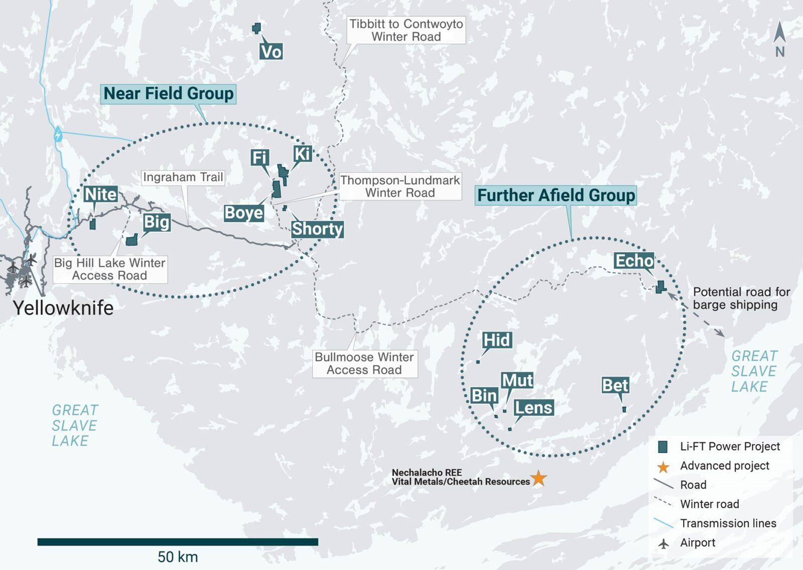
Figure 1 – Location of LIFT’s Yellowknife Lithium Project. Drilling has been thus far mainly focused on the Near Field Group of pegmatites which are located to the east of the city of Yellowknife along a government-maintained paved highway, and advancing to the Echo target, the first drilling in the Further Afield Group.
BIG East Pegmatite
The BIG East pegmatite complex comprises a north-northeast trending corridor of parallel-trending dykes that is exposed for at least 1.8 km of strike length, ranges from 10-100 m wide, and dips approximately 55°-75° degrees to the west. The four holes reported here were all drilled at the northern end of this pegmatite complex and are presented below from southern- to northern-most.
YLP-0271 and YLP0262 are the most northerly holes drilled on the BIG East main pegmatite complex to date, with YLP-0271 collared 50 m north-northeast of YLP-0258 and designed to test the BIG East corridor 75-100 m below the surface. YLP-0271 intersected a 38 m wide pegmatite dyke that returned a composite of 1.34% Li2O over 35 m (Table 1 & 2, Figures 2 & 3).

Figure 2 – Plan view showing the surface expression of the BIG East pegmatite with diamond drill holes reported in this press release.

Figure 3 – Cross-section illustrating YLP-0271 with results as shown in the BIG East pegmatite dyke with a 35 m interval of 1.34% Li2O.
YLP-0262 is the most northerly hole drilled on the main BIG East complex, collared 50 m north-northeast of YLP-0271, the hole was designed to intersect the corridor 50 m beneath the surface. Drilling intersected a 42 m wide corridor with 28 m of pegmatite in two dykes. The lower dyke is 11 m wide and returned a wall-to-wall composite of 1.22% Li2O whereas the 17 m wide upper dyke returned negligible grade. Overall, results from these four holes show that the northern end of the BIG East complex is open at depth and along strike to the northeast (Table 1 & 2, Figures 2 & 4).
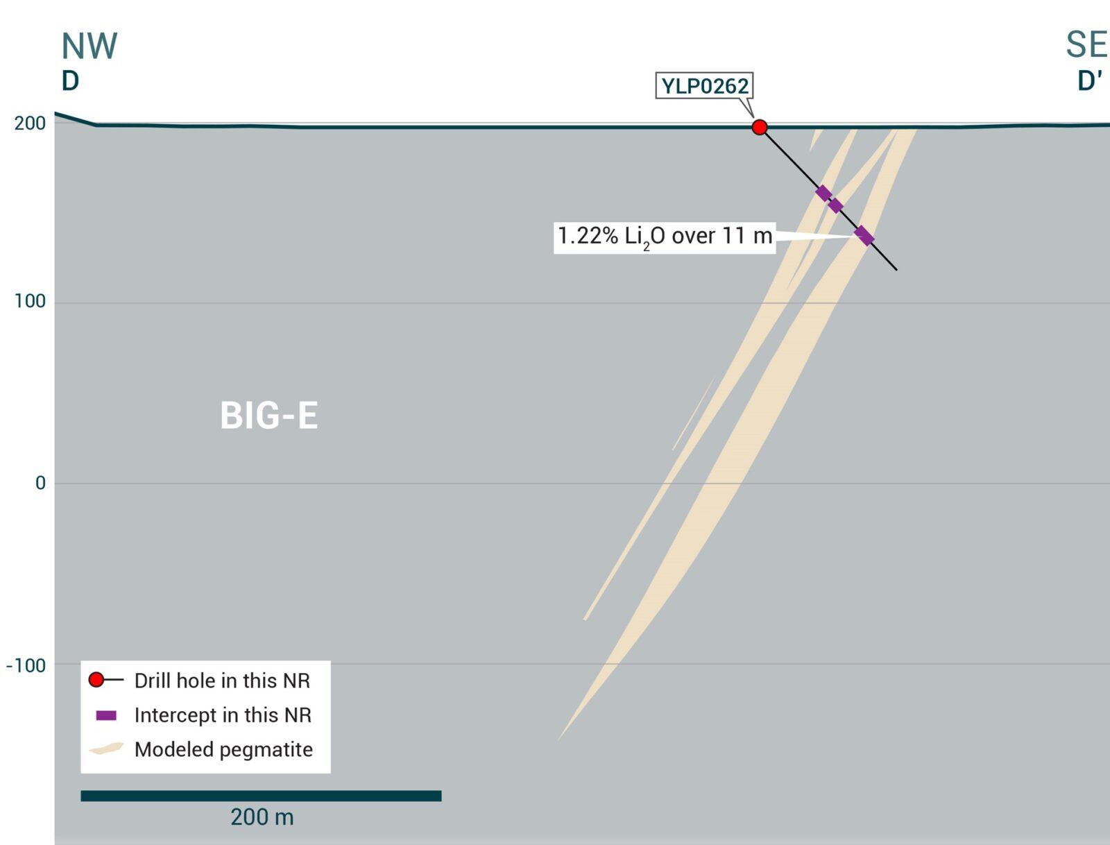
Figure 4 – Cross-section illustrating YLP-0262 with results as shown in the BIG East pegmatite dyke with a 11 m interval of 1.22% Li2O.
YLP-0251 was drilled 150 m from the northern mapped extent of the BIG East complex to test between 75-100 m below the surface and 25-50 m downdip of previously released YLP-0066 (1.34% Li2O over 20 m from two intervals 7 m apart). Drilling intersected a 32 m wide pegmatite dyke that returned an assay composite of 1.06% Li2O over 28 m that includes 10 m of 1.69% Li2O and 3 m of 1.59% Li2O (Table 1 & 2, Figures 2 & 5).

Figure 5 – Cross-section illustrating YLP-0251 with results as shown in the BIG East pegmatite dyke with a 28 m interval of 1.06% Li2O.
YLP-0258 was collared 50 m north-northeast of YLP-0251 to test the BIG East complex approximately 75 m beneath the surface and 50 m downdip of previously released YLP-0074 (0.82% Li2O over 22 m). Drilling intersected a 28 m wide pegmatite dyke that returned an assay composite of 1.48% Li2O over 16 m (Table 1 & 2, Figures 2 & 6).
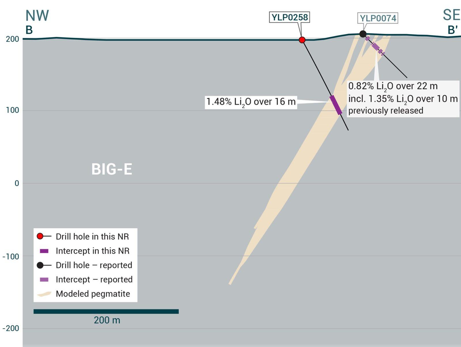
Figure 6 – Cross-section illustrating YLP-0258 with results as shown in the BIG East pegmatite dyke with a 16 m interval of 1.48% Li2O.
Echo Pegmatite System
The Echo pegmatite complex comprises a fanning splay of moderate to gently dipping dykes for 0.5 km to the northwest (“Echo splay”). At its east end, the Echo Splay is connected to a steeply dipping, northwest-trending, feeder dyke (“Echo feeder”). The dyke complex has a total strike length of over 1.0 km. The feeder dyke is 10-15 m wide whereas the gently dipping dykes in the splay are thicker, ranging from 10-25 m. Seven of the holes reported here were drilled on the feeder dyke and are described below from northern to southern most whereas one hole was drilled on the splay.
YLP-0246 was drilled on a section 50 m south-southeast of the section with YLP-0235/0240 to test the Echo feeder at 50 m below the surface. Drilling intersected 7 m and 20 m wide pegmatite dykes separated by 34 m of country rock, with the lower dyke returning a composite of 1.02% Li2O over 14 m. The upper dyke returned negligible grade (Table 1 & 2, Figures 7 & 8).

Figure 7 – Plan view showing the surface expression of the Echo pegmatite with diamond drill holes reported in this press release.

Figure 8 – Cross-section illustrating YLP-0246 with results as shown in the Echo pegmatite dyke with a 14 m interval of 1.02% Li2O.
YLP-0240 tested the Echo feeder dyke on a section approximately 200 m south-southeast of where it merges with the splay, 100 m below the surface, and 75 m downdip of previously released YLP-0235 (1.25% Li2O over 10 m). Drilling intersected a 9 m wide dyke with a wall-to-wall composite of 1.04% Li2O that includes 4 m of 1.98% Li2O (Table 1 & 2, Figure 7).
YLP-0254 was drilled on a section located 100 m south-southeast of YLP-0248 to test the Echo feeder at 125 m below the surface. Drilling intersected a 7 m wide dyke that returned a composite of 1.23% Li2O over 6 m (Table 1 & 2, Figure 7).
YLP-0248 was collared 50 m south of YLP-0246 to test the Echo feeder at 25-50 m below the surface. Drilling intersected an 11 m wide pegmatite dyke that returned a wall-to-wall composite of 0.92% Li2O that includes 5 m at 1.68% Li2O (Table 1 & 2, Figure 7).
YLP-0236 was drilled on a section located 50 m south-southeast of YLP-0239 to test the Echo feeder at 25-50 m below the surface. Drilling intersected a 7 m wide dyke that returned a wall-to-wall composite of 0.79% Li2O that includes 3 m of 1.42% Li2O (Table 1 & 2, Figure 7).
YLP-0245 was collared on the southern-most section to test the Echo feeder dyke, located 100 m south-southeast of the section with hole YLP-0236 and designed to test at 25 m below the surface. Drilling intersected a 7 m wide dyke with a wall-to-wall composite of 0.62% Li2O that includes 3 m of 1.30% Li2O (Table 1 & 2, Figure 7).
YLP-0239 was drilled on a section located 50 m south-southeast of YLP-0254 to test the Echo feeder at 25 m below the surface. Drilling intersected a 7 m wide dyke that returned a composite of 0.51% Li2O over 1 m (Table 1 & 2, Figure 7).
YLP-0222 is the only hole reported here that was drilled into the Echo splay, with the hole collared in the area where the splay merges with the feeder and stepped forward approximately 80 m from previously released YLP-0223 (1.45% Li2O over 15 m). Drilling intersected two pegmatite dykes that are each just 2 m wide and returned negligible grades (Table 1 & 2, Figure 7).
Fi Main Pegmatite
The Fi Main pegmatite complex crops out over at least 1.5 km of strike length within a north-south striking corridor that dips between 70°-85° to the west. The central 800-900 m of the complex can be split into a northern part where most pegmatite occurs in a single 25-30 m thick dyke and a southern part where this dyke splits into upper and lower pegmatites that then remerge 450 m further south. The width of the Fi Main corridor ranges from 25-75 m where it is dominated by a single dyke and between 75-150 m where it is split into two.
YLP-0247 was drilled on the southern part of the Fi Main complex where it is split into an upper and lower zone. This hole was designed to test the upper zone at 50 m below the surface and the lower zone at around 125 m, as well as 25-50 m downdip of previously released YLP-0018 (0.81% Li2O over 19 m from two dykes, 59 m apart) as well as 200-250 m up-dip of YLP-0137 and YLP-0019 (both no significant results). New drilling intersected a 29 m wide upper zone that returned a wall-to-wall composite of 0.52% Li2O as well as a 19 m wide lower zone that returned a composite of 0.50% Li2O over 11 m. Both zones include higher-grade subintervals of 1.0-1.1% Li2O over 5-10 m (Table 1 & 2, Figures 9 & 10).
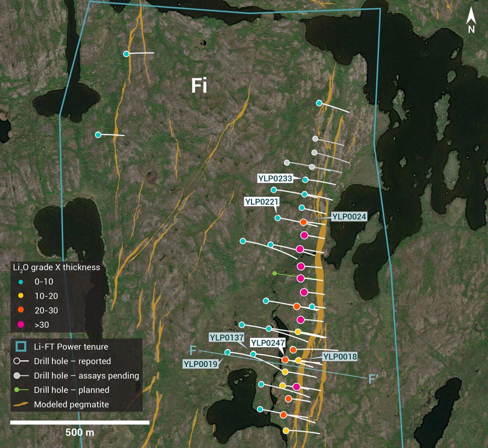
Figure 9 – Plan view showing the surface expression of the Fi Main pegmatite with diamond drill holes reported in this press release.

Figure 10 – Cross-section illustrating YLP-0247 with results as shown in the Fi Main pegmatite dyke with a 29 m interval of 0.52% Li2O.
YLP-0221 was drilled in the northern part of the Fi Main complex, near where it splits from a single dyke in the south into a splay towards the north. The hole was designed to test the Fi Main corridor at 100-150 m below the surface and 50-100 m downdip of previously released YLP-0024 (1.12% Li2O over 24 m). New drilling intersected a 105 m wide corridor with 40 m of pegmatite spread over five dykes that all returned average grades of <0.2% Li2O (Table 1 & 2, Figure 9).
YLP-0233 was drilled on a section located 150 m north of the section with YLP-0024/0221 to test the Fi Main corridor at 50-100 m below the surface. Drilling intersected a 124 m wide corridor with 44 m of pegmatite spread over eight dykes that all returned average grades of ≤0.1% Li2O (Table 1 & 2, Figure 9).
BIG North Pegmatite
The BIG North pegmatite occurs 0.5 km north of the BIG East complex and possibly forms an en echelon array with it. The BIG North dyke has been mapped for 350 m along strike, trends north-northeast, and dips moderate to steeply to the west.
YLP-0243 was collared 100 m south-southwest and along strike of previously released YLP-0129 (0.95% Li2O over 18 m) to test the BIG North corridor at approximately 50 m below the surface. This 140 m long hole failed to intersect pegmatite and no samples were taken (Table 1 & 2, Figure 2).
Table 1 – Assay highlights for drill holes reported in this press release
| Hole No. | From (m) | To (m) | Interval (m) | Li2O% | Dyke |
| YLP-0221 | No significant results | Fi Main | |||
| YLP-0222 | No significant results | Echo | |||
| YLP-0233 | No significant results | Fi Main | |||
| YLP-0236 | 49 | 56 | 7 | 0.79 | Echo |
| inc | 52 | 55 | 3 | 1.42 | |
| YLP-0239 | 44 | 45 | 1 | 0.51 | Echo |
| YLP-0240 | 137 | 146 | 9 | 1.04 | Echo |
| inc | 139 | 143 | 4 | 1.98 | |
| YLP-0243 | No significant results | BIG North | |||
| YLP-0245 | 49 | 56 | 7 | 0.62 | Echo |
| inc | 51 | 54 | 3 | 1.30 | |
| YLP-0246 | 66 | 80 | 14 | 1.02 | Echo |
| YLP-0247 | 48 | 77 | 29 | 0.52 | Fi Main |
| inc | 64 | 74 | 10 | 1.11 | |
| and | 162 | 173 | 11 | 0.50 | |
| inc | 164 | 169 | 5 | 1.03 | |
| YLP-0248 | 47 | 58 | 11 | 0.92 | Echo |
| inc | 50 | 55 | 5 | 1.68 | |
| YLP-0251 | 99 | 127 | 28 | 1.06 | BIG East |
| inc | 99 | 109 | 10 | 1.69 | |
| and inc | 124 | 127 | 3 | 1.59 | |
| YLP-0254 | 145 | 151 | 6 | 1.23 | Echo |
| YLP-0258 | 88 | 104 | 16 | 1.48 | BIG East |
| YLP-0262 | 78 | 89 | 11 | 1.22 | BIG East |
| YLP-0271 | 84 | 119 | 35 | 1.34 | BIG East |
Drilling Progress Update
Currently, LIFT has reported results from 245 diamond drill holes (42,434 m). The Company concluded its winter drill program at the Yellowknife Lithium Project with a combined total of 286 diamond drill holes (49,548 m) completed between the summer and winter programs.
General Statements
All 16 holes described in this news release were drilled broadly perpendicular to the dyke orientation so that the true thickness of reported intercepts will range somewhere between 65-100% of the drilled widths. A collar header table is provided below.
Mineralogical characterization for the YLP- pegmatites is in progress through hyperspectral core scanning and X-ray diffraction work. Visual core logging indicates that the predominant host mineral is spodumene.
Table 2 – Drill collars table of reported drill holes in this press release
| Drill Hole | NAD83 | Easting | Northing | Elevation (m) | Depth (m) | Azimuth (°) | Dip (°) | Dyke |
| YLP-0221 | Zone 12N | 371,701 | 6,942,039 | 256 | 231 | 98 | 51 | Fi Main |
| YLP-0222 | Zone 12N | 439,356 | 6,922,547 | 299 | 120 | 215 | 45 | Echo |
| YLP-0233 | Zone 12N | 371,800 | 6,942,176 | 254 | 153 | 98 | 45 | Fi Main |
| YLP-0236 | Zone 12N | 439,693 | 6,922,184 | 289 | 102 | 241 | 45 | Echo |
| YLP-0239 | Zone 12N | 439,659 | 6,922,222 | 290 | 81 | 241 | 55 | Echo |
| YLP-0240 | Zone 12N | 439,634 | 6,922,493 | 281 | 171 | 240 | 48 | Echo |
| YLP-0243 | Zone 12N | 346,173 | 6,933,842 | 172 | 140 | 121 | 46 | BIG North |
| YLP-0245 | Zone 12N | 439,739 | 6,922,094 | 289 | 72 | 240 | 45 | Echo |
| YLP-0246 | Zone 12N | 439,586 | 6,922,415 | 286 | 102 | 236 | 45 | Echo |
| YLP-0247 | Zone 12N | 371,736 | 6,941,532 | 246 | 243 | 96 | 50 | Fi Main |
| YLP-0248 | Zone 12N | 439,587 | 6,922,354 | 290 | 81 | 240 | 64 | Echo |
| YLP-0251 | Zone 12N | 346,153 | 6,933,330 | 172 | 161 | 121 | 45 | BIG East |
| YLP-0254 | Zone 12N | 439,729 | 6,922,319 | 283 | 168 | 240 | 56 | Echo |
| YLP-0258 | Zone 12N | 346,209 | 6,933,354 | 170 | 140 | 121 | 62 | BIG East |
| YLP-0262 | Zone 12N | 346,283 | 6,933,427 | 197 | 110 | 121 | 45 | BIG East |
| YLP-0271 | Zone 12N | 346,237 | 6,933,396 | 197 | 152 | 121 | 63 | BIG East |
QA/QC & Core Sampling Protocols
All drill core samples were collected under the supervision of LIFT employees and contractors. Drill core was transported from the drill platform to the core processing facility where it was logged, photographed, and split by diamond saw prior to being sampled. Samples were then bagged, and blanks and certified reference materials were inserted at regular intervals. Field duplicates consisting of quarter-cut core samples were also included in the sample runs. Groups of samples were placed in large bags, sealed with numbered tags in order to maintain a chain-of-custody, and transported from LIFT’s core logging facility to ALS Labs (“ALS”) laboratory in Yellowknife, Northwest Territories.
Sample preparation and analytical work for this drill program were carried out by ALS. Samples were prepared for analysis according to ALS method CRU31: individual samples were crushed to 70% passing through 2 mm (10 mesh) screen; a 1,000-gram sub-sample was riffle split (SPL-21) and then pulverized (PUL-32) such that 85% passed through 75 micron (200 mesh) screen. A 0.2-gram sub-sample of the pulverized material was then dissolved in a sodium peroxide solution and analysed for lithium according to ALS method ME-ICP82b. Another 0.2-gram sub-sample of the pulverized material was analysed for 53 elements according to ALS method ME-MS89L. All results passed the QA/QC screening at the lab, all inserted standards and blanks returned results that were within acceptable limits.
Qualified Person
The disclosure in this news release of scientific and technical information regarding LIFT’s mineral properties has been reviewed and approved by Ron Voordouw, Ph.D., P.Geo., Partner, Director Geoscience, Equity Exploration Consultants Ltd., and a Qualified Person as defined by National Instrument 43-101 Standards of Disclosure for Mineral Projects (NI 43-101) and member in good standing with the Northwest Territories and Nunavut Association of Professional Engineers and Geoscientists (NAPEG) (Geologist Registration number: L5245).
About LIFT
LIFT is a mineral exploration company engaged in the acquisition, exploration, and development of lithium pegmatite projects located in Canada. The Company’s flagship project is the Yellowknife Lithium Project located in Northwest Territories, Canada. LIFT also holds three early-stage exploration properties in Quebec, Canada with excellent potential for the discovery of buried lithium pegmatites, as well as the Cali Project in Northwest Territories within the Little Nahanni Pegmatite Group.
CPM Group’s 10-Year Copper Outlook are now available. ... READ MORE
Arizona Gold and Silver Inc. (TSX-V: AZS) (OTCQB: AZASF) is ple... READ MORE
Brixton Metals Corporation (TSX-V: BBB) (OTCQX: BBBXF) is pleased... READ MORE
Valkea Resources Corp. (TSX-V: OZ) is pleased to announce the clo... READ MORE
Tiger Gold Corp. (TSX-V: TIGR) (FSE: D150) (OTCQB: TGRGF) is plea... READ MORE


