


Li-FT Power Ltd. (TSX-V: LIFT) (OTCQX: LIFFF) (Frankfurt: WS0) is pleased to report assays from 12 drill holes completed at the Shorty, BIG East, Echo, Fi Main, & Ki pegmatites within the Yellowknife Lithium Project located outside the city of Yellowknife, Northwest Territories (Figure 1). Drilling intersected significant intervals of spodumene mineralization, with the following highlights:
Highlights:
Discussion of Results
This news release provides results for 12 drill holes (1,918 m) from Li-FT’s 2024 winter drilling program. Holes are reported from five different pegmatite complexes that include Shorty, Ki, Echo, BIG East, and Fi Main. A table of composite calculations, general comments related to this discussion, and a table of collar headers are provided towards the end of this section.
Dave Smithson, SVP Geology of LIFT comments, “Shorty continues to deliver near-surface high grade spodumene mineralization this week, with YLP-0283 returning an impressive 35 m of 1.32% Li2O only 50 m from surface. The intercept extends strong shallow mineralization drilled 100 m to the southwest in holes YLP091 & YLP097 (17 m of 1.28% Li2O, 16 m of 1.01% Li2O, and 23 m of 1.03% Li2O) from 2023. This new information extends high grade mineralization for a total of 400 m on surface at Shorty emphasising the dyke’s potential to deliver significant high-grade tonnes from surface.”
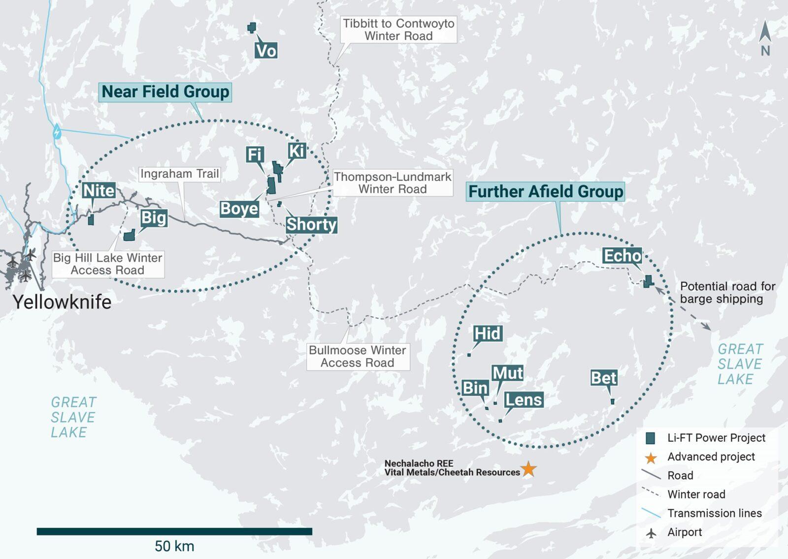
Figure 1 – Location of LIFT’s Yellowknife Lithium Project. Drilling has been thus far mainly focused on the Near Field Group of pegmatites which are located to the east of the city of Yellowknife along a government-maintained paved highway, and advancing to the Echo target, the first drilling in the Further Afield Group.
Shorty Pegmatite
The Shorty pegmatite is formed by several sub-parallel dykes that, together, define a pegmatite-bearing corridor that is at least 1.4 km long, up to 100 m wide, north-northeast striking, and dips 50°-70° to the west. The corridor itself consists of both country rock and pegmatite, with pegmatite occurring as either a single 10-40 m wide dyke or as 2-4 dykes with a similar cumulative width spread over 50-100 m of core length.
YLP-0283 was collared within a few metres of the lease boundary to test the Shorty corridor at approximately 50 to 100 m below the surface and 50 m north of a section with previously released YLP-0089 (1.55% Li2O over 15 m from 2 intervals, 5 m apart). Drilling intersected a 35 m dyke centered at approximately 50 m below the surface that returned a wall-to-wall composite of 1.32% Li2O. This intersection is the northeastern-most hole drilled on Shorty corridor to date with mineralization open at depth and along strike to the north-northeast where it extends off LIFT’s claims (Table 1 & 2, Figures 2 & 3).
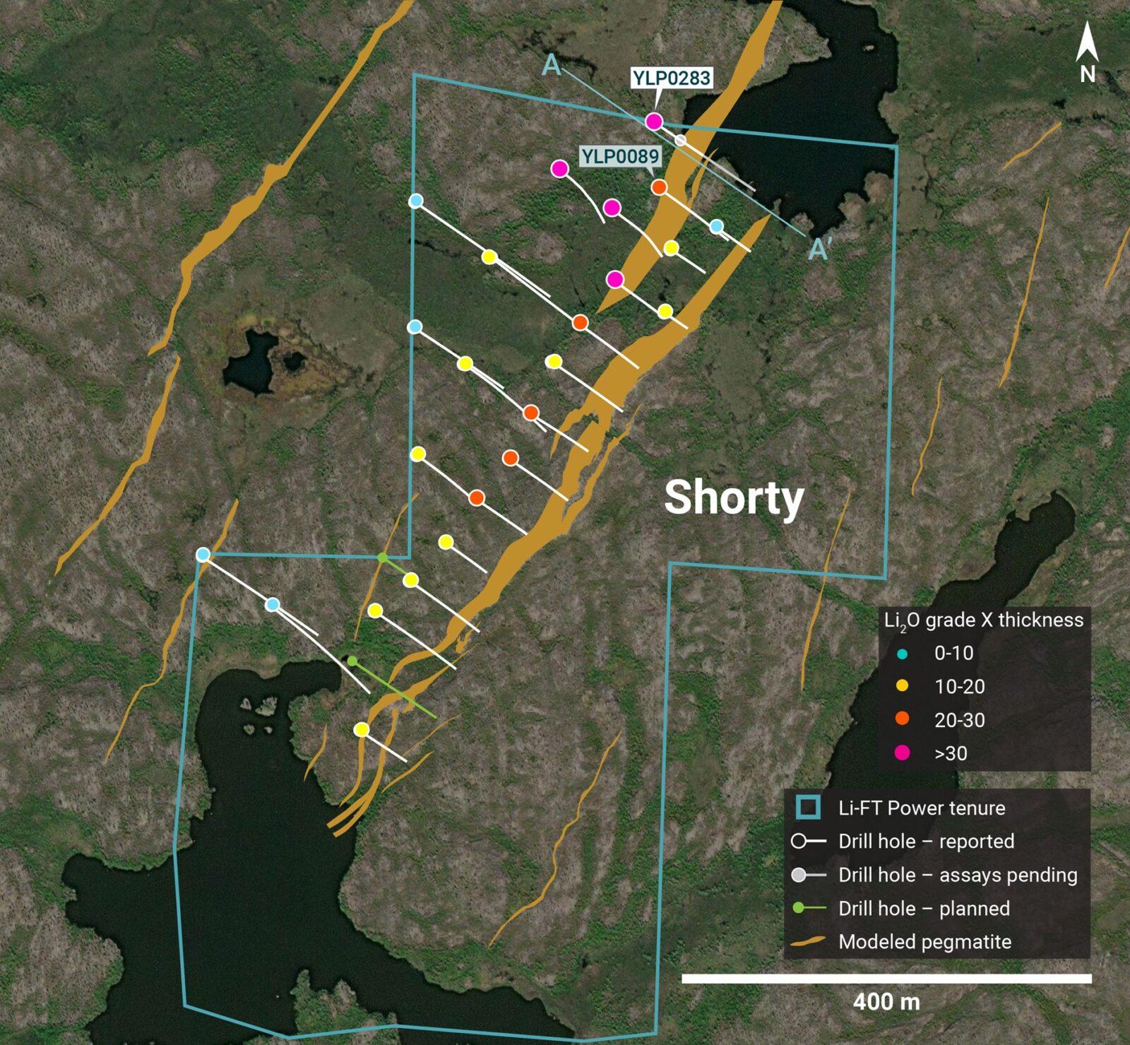
Figure 2 – Plan view showing the surface expression of the Shorty pegmatite with diamond drill holes reported in this press release.
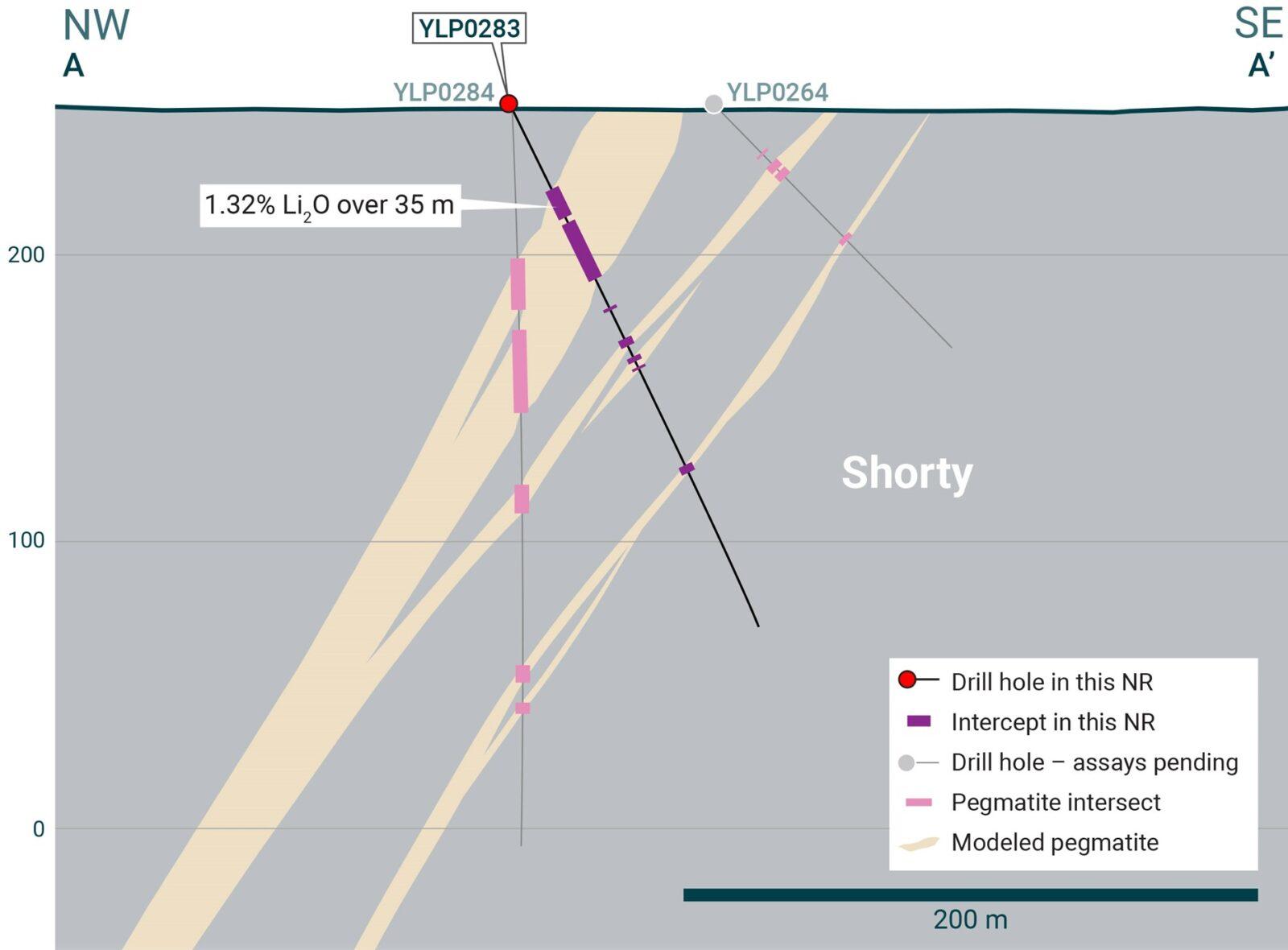
Figure 3 – Cross-section illustrating YLP-0283 with results as shown in the Shorty pegmatite dyke with a 35 m interval of 1.32% Li2O.
Ki Pegmatite
The Ki pegmatite complex comprises a north-northwest trending corridor of dykes that extends for at least 1.3 km on surface and dips steeply to the southwest. The southern part of the corridor consists mostly of one large dyke and several narrower flanking dykes that sum to a constant pegmatite width of around 25 m. The northern part consists of two relatively thick dykes that are between 50-150 m apart, with the western dyke comprising the northern extension of the Ki dyke and the more eastern dyke referred to as Perlis.
YLP-0274 was drilled at the northern end of the Ki dyke where it overlaps with the southern end of the Perlis dyke. The hole was designed to test both dykes at depths of approximately 10 and 75 m below the surface. Drilling intersected the Ki dyke, with a width of 11 m, as well four 1 to 4 m wide dykes spread over 86 m of core further down the hole, the deepest of which is possibly Perlis. The Ki dyke returned a wall-to-wall composite of 1.16% Li2O that includes 6 m of 1.87% Li2O and is open at depth and to the north. The other dykes returned negligible grade (Table 1 & 2, Figures 4 & 5).
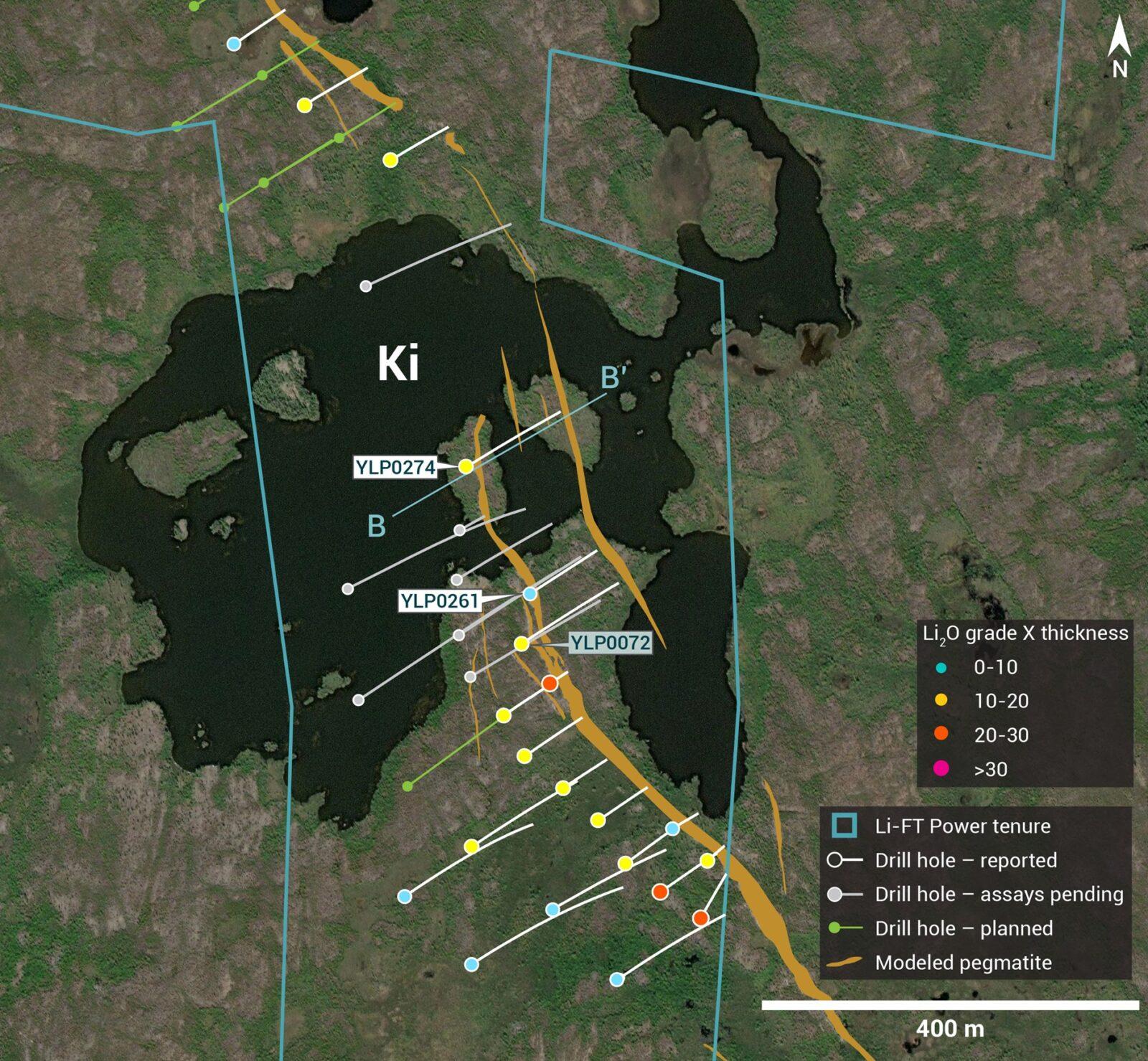
Figure 4 – Plan view showing the surface expression of the Ki pegmatite with diamond drill holes reported in this press release.

Figure 5 – Cross-section illustrating YLP-0274 with results as shown in the Ki pegmatite dyke with a 11 m interval of 1.16% Li2O.
YLP-0261 was collared 150 m southeast of YLP-0274 to test the Ki corridor from approximately 5 to 75 m below the surface and 50 m north of previously released YLP-0072 (0.79% Li2O over 17 m). New drilling intersected a dyke cluster just below overburden and another centered at 75 m depth, with the shallower cluster returning a composite of 0.56% Li2O over 3 m (Table 1 & 2, Figure 4).
Echo Pegmatite
The Echo pegmatite complex comprises a steeply dipping, northwest-trending, feeder dyke that splits into a fanning splay of moderate to gently dipping dykes for 0.5 km to the northwest. The dyke complex has a total strike length of over 1.0 km. The feeder dyke is 10-15 m wide whereas the gently dipping dykes in the splay are thicker, ranging from 10-25 m. All six of the holes reported here were drilled on the feeder dyke and are described below from northern to southernmost.
YLP-0263 tested the Echo feeder dyke near where it merges with the Echo splay, approximately 75 m below the surface and 50 m downdip of previously released YLP-0226 (1.45% Li2O over 13 m). New drilling intersected 6 and 12 m wide dykes separated by 7 m of country rock, with the thicker dyke returning a wall-to-wall composite of 0.82% Li2O that includes 6 m of 1.29% Li2O. High grade spodumene mineralization is cut out by a mafic dyke but is open at depth and along strike to the north (Table 1 & 2, Figures 6 & 7).

Figure 6 – Plan view showing the surface expression of the Echo pegmatite with diamond drill holes reported in this press release.
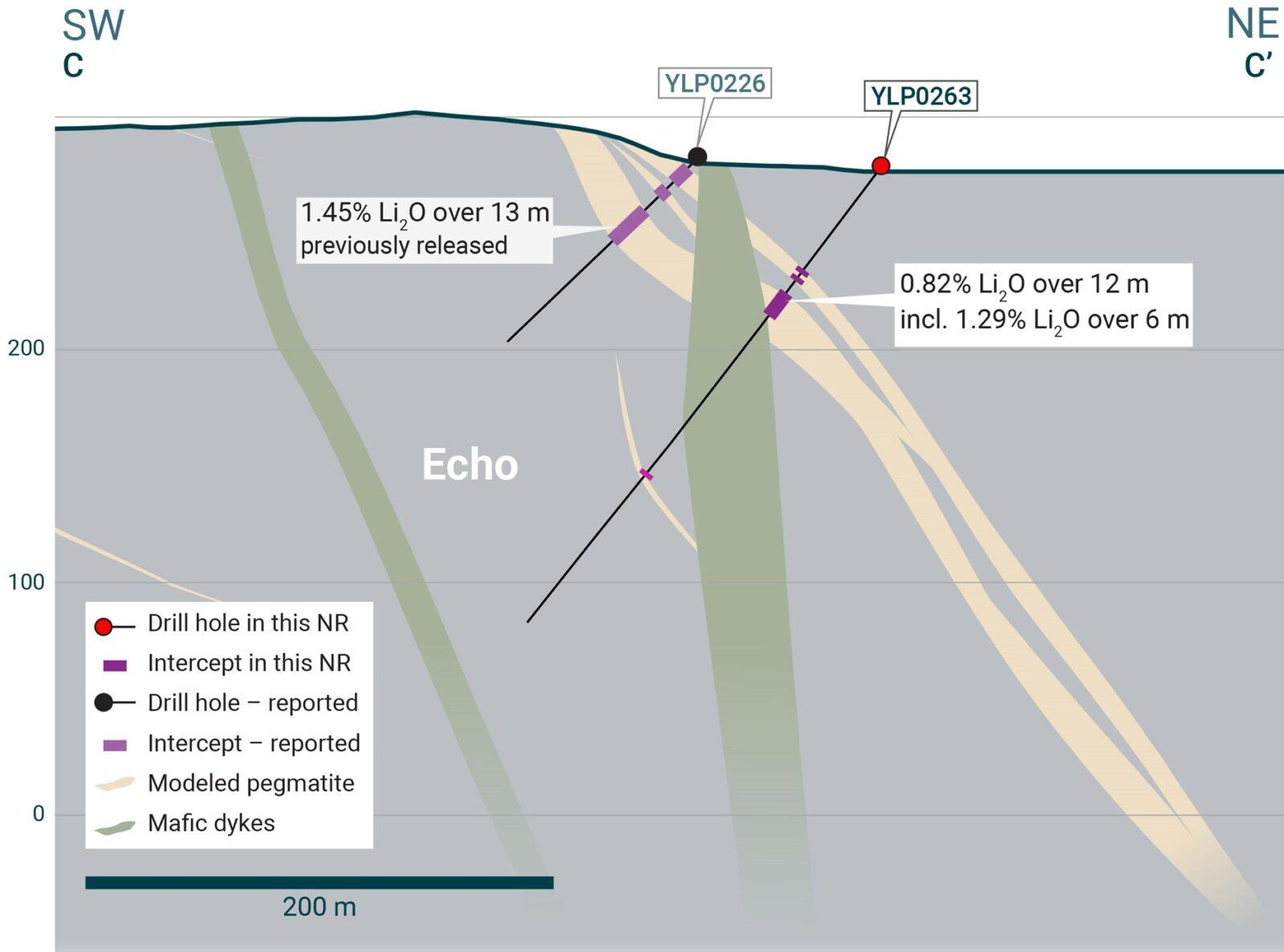
Figure 7 – Cross-section illustrating YLP-0263 with results as shown in the Echo pegmatite dyke with a 12 m interval of 0.82% Li2O.
YLP-0253 was drilled on a section 275 m south of the section with YLP-0226/0263 to test the Echo feeder at 125-150 m below the surface and 100 metres downdip of previously released YLP-0248 (0.92% Li2O over 11 m). New drilling intersected a nine-metre-wide feeder dyke that returned a composite of 0.50% Li2O over 6 m (Table 1 & 2, Figure 6).
YLP-0256 was drilled on a section 50 m south of the section with YLP-0248/0253 to test the Echo feeder approximately 25-50 m below the surface. Drilling intersected a 26 m wide corridor with 10 m of pegmatite spread over three dykes, one of which returned a composite of 0.57% Li2O over 3 m (Table 1 & 2, Figure 6).
YLP-0252 was drilled on a section an additional 50 m south to test the Echo feeder at 25-50 m below the surface and 100 m up-dip of YLP-0254 (1.23% Li2O over 6 m). New drilling intersected a 29 m wide corridor with 10 m of pegmatite spread over two dykes, neither of which returned assays over 0.1% Li2O (Table 1 & 2, Figure 6).
YLP-0257 was drilled on a section 100 m south of the previously described hole (YLP-0252) to test the Echo feeder at approximately 100 m below the surface and 75 m downdip of previously released YLP-0236 (0.79% Li2O over 7 m). New drilling intersected several 1 to 3 m wide flanking dykes at shallower depth and then a 7 m wide pegmatite interpreted as the feeder. No significant assays were returned (Table 1 & 2, Figure 6).
YLP-0244 was drilled on a section an additional 100 m south of the previously described hole to test the Echo feeder approximately 100 m from its mapped southern extent, 100 m below the surface, and 75 m downdip of previously released YLP-0245 (0.62% Li2O over 7 m). Drilling intersected a 22 m wide corridor with 11 m of pegmatite spread over two dykes, neither of which returned assays over 0.1% Li2O (Table 1 & 2, Figure 6).
BIG East Pegmatite
The BIG East pegmatite complex comprises a north-northeast trending corridor of parallel-trending dykes that is exposed for at least 1.8 km of strike length, ranges from 10-100 m wide, and dips approximately 55°-75° degrees to the west.
YLP-0267 is the northern-most hole reported from the BIG East complex to date and was drilled to test the corridor at 25-125 m below the surface on a section located 50 m north of previously released hole YLP-0262 (1.22% Li2O over 11 m). Drilling intersected a 25 m wide dyke centered at approximately 100 m below the surface and flanked by one or more 2 to 9 m wide dykes on either side. Assays returned composites of 0.46% Li2O over 3 m and 0.46% Li2O over 8 m from the thick dyke as well as 0.57% Li2O over 1 m from one of the flanking dykes (Table 1 & 2, Figures 8 & 9).
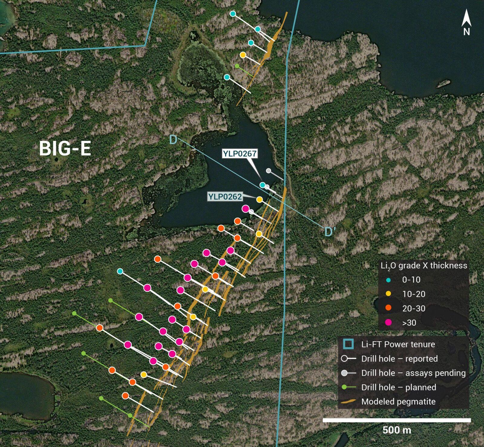
Figure 8 – Plan view showing the surface expression of the BIG East pegmatite with diamond drill holes reported in this press release.
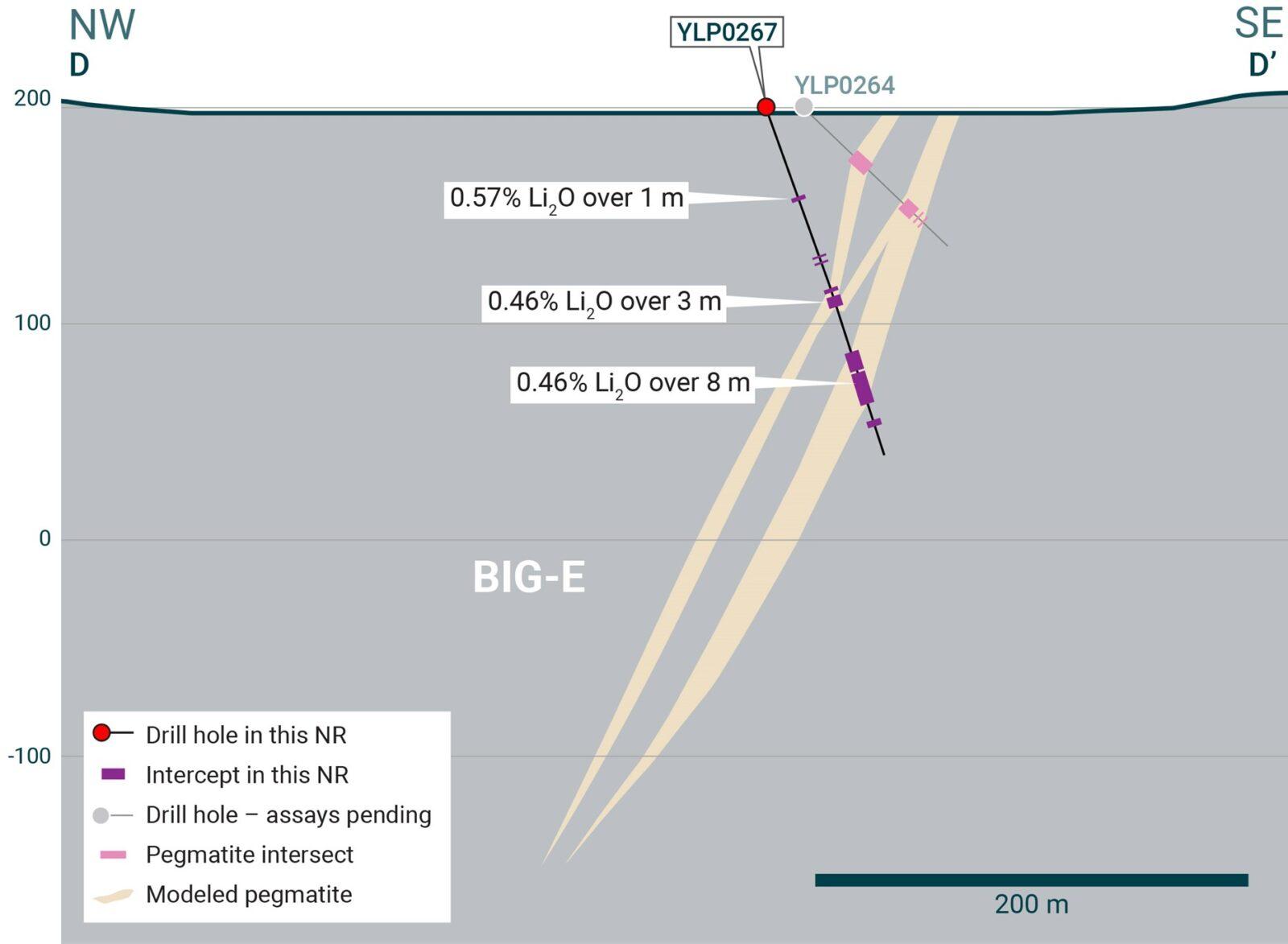
Figure 9 – Cross-section illustrating YLP-0267 with results as shown in the BIG East pegmatite dyke with a 8 m interval of 0.46% Li2O.
Fi Main Pegmatite
The Fi Main pegmatite complex crops out over at least 1.5 km of strike length within a north-south striking corridor that dips between 70°-85° to the west. The central 800-900 m of the complex can be split into a northern part where most pegmatite occurs in a single 25-30 m thick dyke and a southern part where this dyke splits into upper and lower pegmatites that then remerge 450 m further south. The width of the Fi Main corridor ranges from 25-75 m where it is dominated by a single dyke and between 75-150 m where it is split into two or more dykes. The two holes reported here were both drilled at the north end of the complex.
YLP-0250 was drilled to test the Fi Main corridor at approximately 10-125 m below the surface and 100 m due north of previously released YLP-0233 (no significant result). Over a 159 m interval, drilling intersected 11 pegmatite dykes with widths between 1 to 9 m that total to a cumulative pegmatite width of 46 m. Assays all returned ≤0.3% Li2O (Table 1 & 2, Figure 10).
YLP-0255 was drilled 50 m north of YLP-0250 to provide a similar test of the Fi Main corridor between 10-100 m below the surface. Drilling intersected 35 m of pegmatite spread over eight dykes and 101 m of drill core, with all assays returning ≤0.2% Li2O (Table 1 & 2, Figure 10).

Figure 10 – Plan view showing the surface expression of the Fi Main pegmatite with diamond drill holes reported in this press release.
Table 1 – Assay highlights for drill holes reported in this press release
| Hole No. | From (m) | To (m) | Interval (m) | Li2O% | Dyke |
| YLP-0244 | No significant results | Echo | |||
| YLP-0250 | No significant results | Fi Main | |||
| YLP-0252 | No significant results | Echo | |||
| YLP-0253 | 169 | 175 | 6 | 0.50 | Echo |
| YLP-0255 | No significant results | Fi Main | |||
| YLP-0256 | 59 | 62 | 3 | 0.57 | Echo |
| YLP-0257 | No significant results | Echo | |||
| YLP-0261 | 4 | 7 | 3 | 0.56 | Ki |
| YLP-0263 | 66 | 78 | 12 | 0.82 | Echo |
| incl | 69 | 75 | 6 | 1.29 | |
| YLP-0267 | 92 | 93 | 1 | 0.57 | BIG East |
| and | 120 | 123 | 3 | 0.46 | |
| and | 128 | 136 | 8 | 0.46 | |
| YLP-0274 | 7 | 18 | 11 | 1 | Ki |
| incl | 8 | 14 | 6 | 1.87 | |
| YLP-0283 | 31 | 66 | 35 | 1.32 | Shorty |
Drilling Progress Update
Currently, LIFT has reported results from 257 diamond drill holes (44,512 m). The Company concluded its winter drill program at the Yellowknife Lithium Project with a combined total of 286 diamond drill holes (49,548 m) completed between the summer and winter programs.
General Statements
All 12 holes described in this news release were drilled broadly perpendicular to the dyke orientation so that the true thickness of reported intercepts will range somewhere between 65-100% of the drilled widths. A collar header table is provided below.
Mineralogical characterization for the YLP- pegmatites is in progress through hyperspectral core scanning and X-ray diffraction work. Visual core logging indicates that the predominant host mineral is spodumene.
Table 2 – Drill collars table of reported drill holes in this press release
| Drill Hole | NAD83 | Easting | Northing | Elevation (m) | Depth (m) | Azimuth (°) | Dip (°) | Dyke |
| YLP-0244 | Zone 12N | 439,826 | 6,922,145 | 286 | 183 | 240 | 49 | Echo |
| YLP-0250 | Zone 12N | 371,834 | 6,942,274 | 252 | 180 | 100 | 45 | Fi Main |
| YLP-0252 | Zone 12N | 439,641 | 6,922,268 | 288 | 78 | 240 | 62 | Echo |
| YLP-0253 | Zone 12N | 439,717 | 6,922,426 | 277 | 192 | 240 | 45 | Echo |
| YLP-0255 | Zone 12N | 371,837 | 6,942,320 | 253 | 150 | 100 | 46 | Fi Main |
| YLP-0256 | Zone 12N | 439,622 | 6,922,318 | 289 | 78 | 240 | 53 | Echo |
| YLP-0257 | Zone 12N | 439,771 | 6,922,233 | 287 | 165 | 240 | 53 | Echo |
| YLP-0261 | Zone 12N | 373,077 | 6,942,941 | 256 | 120 | 57 | 45 | Ki |
| YLP-0263 | Zone 12N | 439,475 | 6,922,644 | 277 | 246 | 215 | 54 | Echo |
| YLP-0267 | Zone 12N | 346,293 | 6,933,477 | 197 | 167 | 121 | 70 | BIG East |
| YLP-0274 | Zone 12N | 373,011 | 6,943,076 | 254 | 159 | 60 | 45 | Ki |
| YLP-0283 | Zone 12N | 372,957 | 6,938,377 | 251 | 200 | 124 | 64 | Shorty |
QA/QC & Core Sampling Protocols
All drill core samples were collected under the supervision of LIFT employees and contractors. Drill core was transported from the drill platform to the core processing facility where it was logged, photographed, and split by diamond saw prior to being sampled. Samples were then bagged, and blanks and certified reference materials were inserted at regular intervals. Field duplicates consisting of quarter-cut core samples were also included in the sample runs. Groups of samples were placed in large bags, sealed with numbered tags in order to maintain a chain-of-custody, and transported from LIFT’s core logging facility to ALS Labs (“ALS”) laboratory in Yellowknife, Northwest Territories.
Sample preparation and analytical work for this drill program were carried out by ALS. Samples were prepared for analysis according to ALS method CRU31: individual samples were crushed to 70% passing through 2 mm (10 mesh) screen; a 1,000-gram sub-sample was riffle split (SPL-21) and then pulverized (PUL-32) such that 85% passed through 75 micron (200 mesh) screen. A 0.2-gram sub-sample of the pulverized material was then dissolved in a sodium peroxide solution and analysed for lithium according to ALS method ME-ICP82b. Another 0.2-gram sub-sample of the pulverized material was analysed for 53 elements according to ALS method ME-MS89L. All results passed the QA/QC screening at the lab, all inserted standards and blanks returned results that were within acceptable limits.
Qualified Person
The disclosure in this news release of scientific and technical information regarding LIFT’s mineral properties has been reviewed and approved by Ron Voordouw, Ph.D., P.Geo., Partner, Director Geoscience, Equity Exploration Consultants Ltd., and a Qualified Person as defined by National Instrument 43-101 Standards of Disclosure for Mineral Projects (NI 43-101) and member in good standing with the Northwest Territories and Nunavut Association of Professional Engineers and Geoscientists (NAPEG) (Geologist Registration number: L5245).
About LIFT
LIFT is a mineral exploration company engaged in the acquisition, exploration, and development of lithium pegmatite projects located in Canada. The Company’s flagship project is the Yellowknife Lithium Project located in Northwest Territories, Canada. LIFT also holds three early-stage exploration properties in Quebec, Canada with excellent potential for the discovery of buried lithium pegmatites, as well as the Cali Project in Northwest Territories within the Little Nahanni Pegmatite Group.
CPM Group’s 10-Year Copper Outlook are now available. ... READ MORE
Arizona Gold and Silver Inc. (TSX-V: AZS) (OTCQB: AZASF) is ple... READ MORE
Brixton Metals Corporation (TSX-V: BBB) (OTCQX: BBBXF) is pleased... READ MORE
Valkea Resources Corp. (TSX-V: OZ) is pleased to announce the clo... READ MORE
Tiger Gold Corp. (TSX-V: TIGR) (FSE: D150) (OTCQB: TGRGF) is plea... READ MORE


