


Li-FT Power Ltd. (TSX-V: LIFT) (OTCQX: LIFFF) (Frankfurt: WS0) is pleased to report assays from 8 drill holes completed at the Echo, Fi Main, Fi Southwest & Nite pegmatites within the Yellowknife Lithium Project located outside the city of Yellowknife, Northwest Territories (Figure 1). Drilling intersected significant intervals of spodumene mineralization, with the following highlights:
Highlights:
Discussion of Results
This news release provides results for eight drill holes (1,916 m), six of which are from ongoing 2024 winter drilling and two from the 2023 program. Three holes are reported from the Echo pegmatite, two each on Fi Southwest and Nite, and one from Fi Main. A table of composite calculations, general comments related to this discussion, and a table of collar headers are provided towards the end of this section.
Dave Smithson, SVP, Geology of LIFT comments, “We are pleased to see the first results from the southeast end of the Echo pegmatite system where holes 223 and 226 intercepted strong shallow spodumene mineralization averaging 1.55% Li2O over 14 m and 1.45% Li2O over 13 m, respectively. Geological mapping at this portion of the Echo pegmatite system in 2023 reveals that there is still an additional 500 m of strike-length of spodumene-bearing pegmatite that remains untested for follow-up drilling, and so we are very excited to build these initial results by testing the remainder of the dyke to the southeast, to a depth of 250 m from surface.”

Figure 1 – Location of LIFT’s Yellowknife Lithium Project. Drilling has been thus far mainly focused on the Near Field Group of pegmatites which are located to the east of the city of Yellowknife along a government-maintained paved highway, and more recently advancing to the Echo target, the first drilling in the Further Afield Group.
Echo Pegmatite System
The Echo pegmatite complex comprises a fanning splay of moderate to gently dipping dykes for 0.5 km to the northwest (“Echo splay”), apparently sourced from a steeply dipping, northwest-trending, feeder dyke (“Echo feeder”). The dyke complex has a total strike length of over 1.0 km. The feeder dyke is 10-15 m wide whereas the gently dipping dykes in the splay are thicker, ranging from 10-25 m wide. The holes in this news release were drilled into both the Echo splay and Echo feeder dyke.
YLP-0223 is the first hole reported from the Echo feeder dyke and was drilled to test 250 m from its northern mapped extent and 25 m below the surface. Drilling intersected a single 15 m wide pegmatite dyke that returned an assay composite of 1.55% Li2O over 14 m (Table 1 & 2, Figures 2 & 3).

Figure 2 – Plan view showing the surface expression of the Echo pegmatite with diamond drill holes reported in this press release.
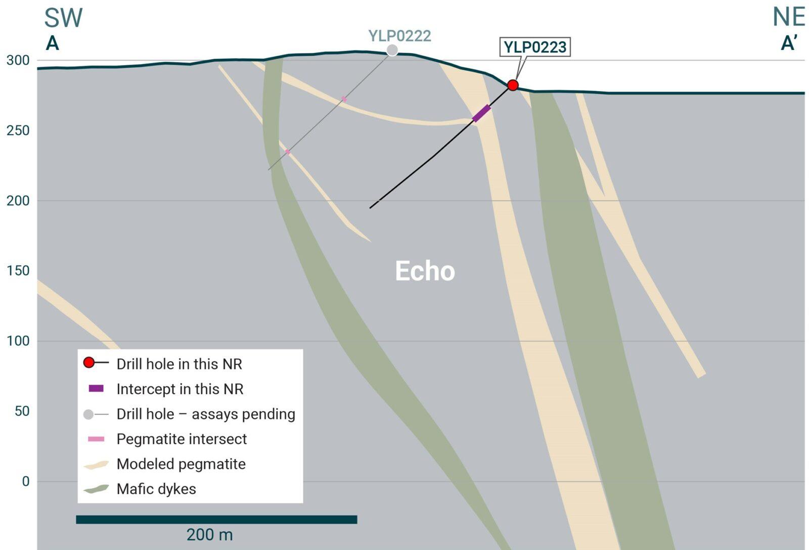
Figure 3 – Cross-section illustrating YLP-0223 with results as shown in the Echo pegmatite dyke with a 14 m interval of 1.55% Li2O.
YLP-0226 was collared 50 m south of YLP-0223 to test the Echo feeder 300 m from its northern mapped extent and 25 m below the surface. Drilling intersected a 41 m corridor with 32 m of pegmatite that includes a 19 m wide dyke that yielded a composite of 1.45% Li2O over 13 m (Table 1 & 2, Figures 2 & 4).

Figure 4 – Cross-section illustrating YLP-0226 with results as shown in the Echo pegmatite dyke with a 13 m interval of 1.45% Li2O.
YLP-0217 was collared 100 m northwest of the Echo feeder to test the Echo splay about 400 m from its northwest mapped extent, <25 to 100 m below the surface, and on section with previously released YLP-0124 (1.52% Li2O over 12 m). Drilling intersected a shallow dipping, 79 m wide, interval with 29 m of pegmatite spread over a 14 m wide dyke and five others between 1-7 m in width. Two of these dykes, spaced 25-30 m apart, combine to form a composite of 0.88% Li2O over 12 m (Table 1 & 2, Figure 2).
Fi Main Pegmatite
The Fi Main pegmatite complex crops out over at least 1.5 km of strike length within a north-south striking corridor that dips between 70°-85° to the west. The central stretch of the complex consists of a 25-30 m thick dyke that is flanked by one or more <5 m wide dykes within a 25-75 m wide corridor. This thick dyke splits to the north and south to form a wider corridor (75-150 m) that hosts a similar volume of pegmatite spread over more and generally narrower dykes.
YLP-0219 was drilled to test the southern part of the Fi Main pegmatite at 150-250 m below the surface. Previously released drill holes that returned on-section intersections of upper pegmatite include YLP-0008 (0.89% Li2O over 20 m, 25 m depth) and YLP-0014 (0.74% Li2O over 23 m, 50 m). New drilling that targeted 150 m beneath the surface intersected a 23 m upper corridor with 17 m of pegmatite grading 0.97% Li2O over 9 m. Previous on-section intersections of lower pegmatite include 0.91% Li2O over 15 m at 75 m depth (YLP-0008) and negligible grade at 100 m depth. (YLP-0014) New drilling intersected a 20 m wide lower corridor with 13 m of pegmatite that returned negligible grade (Table 1 & 2, Figures 5 & 6).
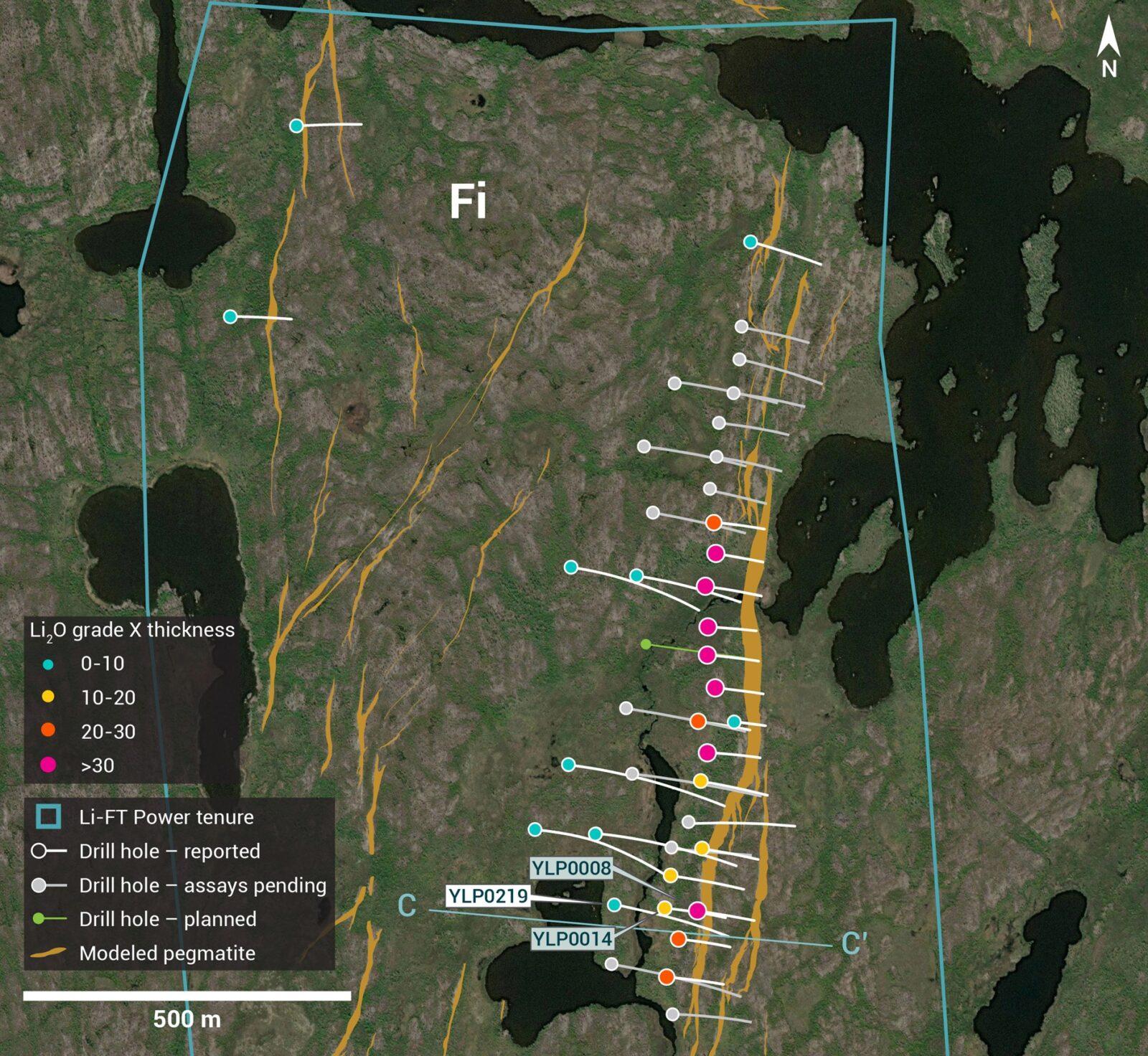
Figure 5 – Plan view showing the surface expression of the Fi Main pegmatite with diamond drill holes reported in this press release.

Figure 6 – Cross-section illustrating YLP-0219 with results as shown in the Fi Main pegmatite dyke with a 9 m interval of 0.97% Li2O.
Fi Southwest Pegmatite
The Fi Southwest (Fi-SW) pegmatite complex is exposed over at least 1.1 km on surface and occurs within a broader corridor that is 50-100 m wide and dips between 60°-80° to the east. The complex is cored by a 20-40 m wide main dyke that is continuous for at least 800 m along strike, with numerous sub-parallel subsidiary dykes between 1-5 m in width. At its northern and southern ends, the main dyke splays out into a broader corridor with more dykes that have narrower widths. YLP-0201 and YLP-0206 both tested the northern splay.
YLP-0201 was drilled on a section 150 m beyond the mapped northern extent of the main dyke to test at 50 m below the surface. Drilling intersected a 63 m wide corridor with 7 m of pegmatite spread over two dykes, neither of which returned significant grade.
YLP-0206 was collared on a section 100 m south of YLP-0201 to test at 250 m below the surface and just beyond the mapped northern tip of the main dyke. Previously released drilling on this section returned 1.03% Li2O over 24 m from 50-100 m depth (YLP-0051), 1.32% Li2O over 14 m from 125-150 m (YLP-0075), and 1.06% Li2O over 16 m from 150-175 m depth (YLP-0081). New drilling intersected a 24 m wide corridor with 19 m of pegmatite that assayed negligible grade (Table 1 & 2, Figure 7).
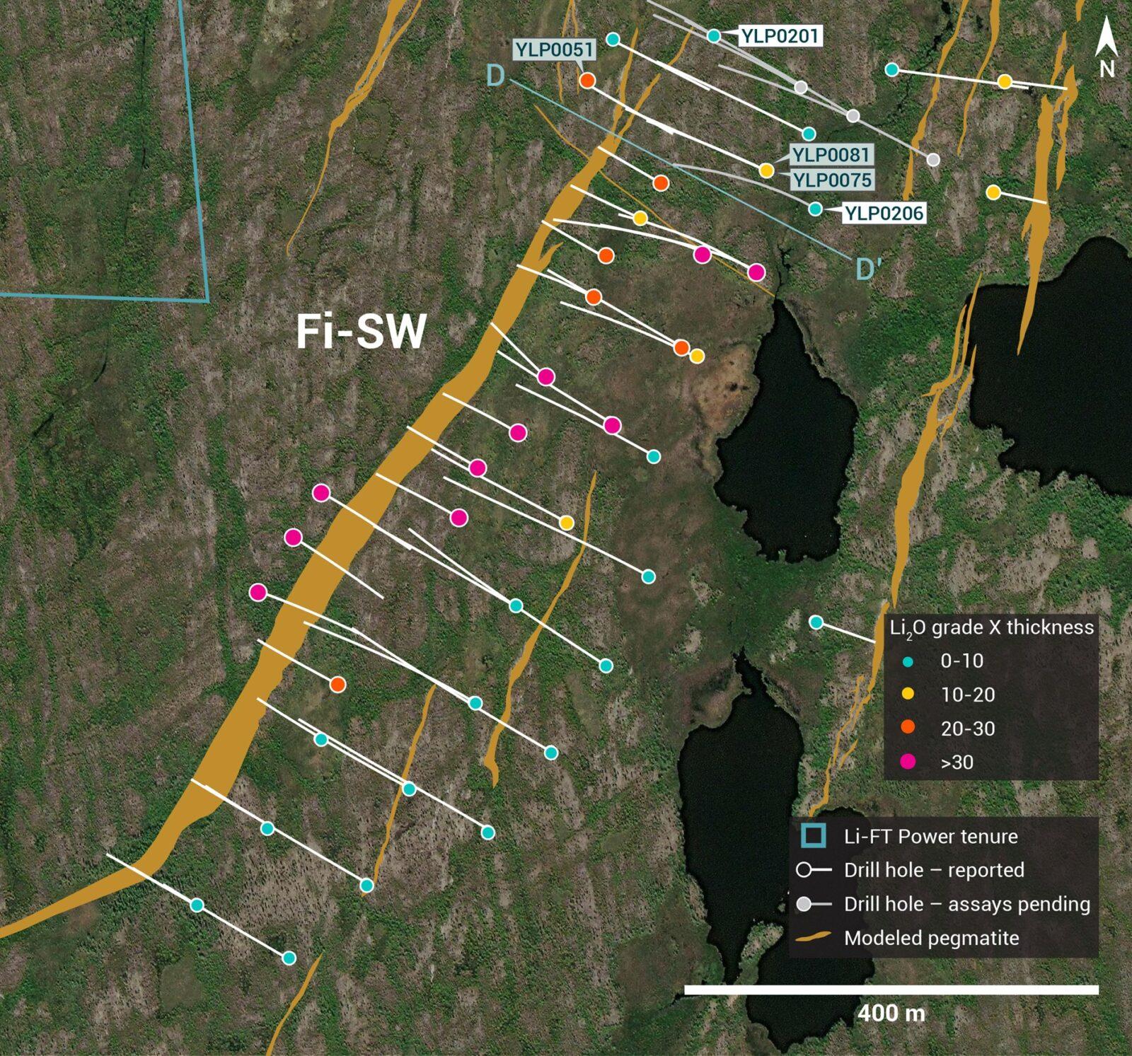
Figure 7 – Plan view showing the surface expression of the Fi Southwest pegmatite with diamond drill holes reported in this press release.
Nite Pegmatite
The Nite pegmatite complex is exposed along 1.4 km of strike length as a swarm of parallel-trending dykes that occur within a north-northeast striking corridor dipping ~50°-70° degrees to the east. The northern part of this complex consists of a 5-15 m thick dyke flanked by one or more 1-5 m dykes whereas the southern part comprises a fanning splay of 5-10 thin dykes within a 200 m wide corridor.
YLP-0194 was drilled to test the main pegmatite at 400 m from its northern mapped extent and 200-225 m below the surface. Previous drilling on the same section returned 1.24% Li2O over 5 m from 50 m depth (YLP-0152) and 0.87% Li2O over 6 m from 150 m (YLP-0192). New drilling intersected a 20 m wide corridor with 13 m of pegmatite that returned negligible grade.
YLP-0197 was collared on a section 200 m south of YLP-0194 to test the Nite main pegmatite at 250 m below the surface. Previously released drilling on the same section returned 0.58% Li2O over 17 m from 50 m depth (YLP-0196) and 0.81% Li2O over 13 m from 150 m (YLP-0198). New drilling intersected a 44 m wide corridor with 22 m of pegmatite that returned negligible grade (Table 1 & 2, Figure 8).

Figure 8 – Plan view showing the surface expression of the Nite pegmatite with diamond drill holes reported in this press release.
|
Table 1 – Assay highlights for drill holes reported in this press release. |
| Hole No. | From (m) | To (m) | Interval (m) | Li2O% | Dyke |
| YLP-0194 | No significant results | Nite | |||
| YLP-0197 | No significant results | Nite | |||
| YLP-0201 | No significant results | Fi SW | |||
| YLP-0206 | No significant results | Fi SW | |||
| YLP-0217 | 16 | 26 | 10 | 0.93 | Echo |
| and | 54 | 56 | 2 | 0.63 | |
| YLP-0219 | 181 | 190 | 9 | 0.97 | Fi Main |
| YLP-0223 | 20 | 34 | 14 | 1.55 | Echo |
| YLP-0226 | 34 | 47 | 13 | 1.45 | Echo |
General Statements
All eight holes described in this news release were drilled broadly perpendicular to the dyke orientation so that the true thickness of reported intercepts will range somewhere between 65-100% of the drilled widths. A collar header table is provided below.
Mineralogical characterization for the YLP- pegmatites is in progress through hyperspectral core scanning and X-ray diffraction work. Visual core logging indicates that the predominant host mineral is spodumene.
|
Table 2 – Drill collars table of reported drill holes in this press release |
| Drill Hole | NAD83 | Easting | Northing | Elevation (m) | Depth (m) | Azimuth (°) | Dip (°) | Dyke |
| YLP-0194 | Zone 11 | 647,802 | 6,936,487 | 206 | 341 | 298 | 53 | Nite |
| YLP-0197 | Zone 11 | 647,722 | 6,936,301 | 208 | 360 | 298 | 53 | Nite |
| YLP-0201 | Zone 12 | 371,513 | 6,941,165 | 252 | 102 | 302 | 45 | Fi SW |
| YLP-0206 | Zone 12 | 371,611 | 6,940,998 | 250 | 372 | 300 | 68 | Fi SW |
| YLP-0217 | Zone 12 | 439,296 | 6,922,654 | 295 | 171 | 215 | 45 | Echo |
| YLP-0219 | Zone 12 | 371,642 | 6,941,442 | 251 | 327 | 98 | 56 | Fi Main |
| YLP-0223 | Zone 12 | 439,397 | 6,922,617 | 279 | 132 | 216 | 45 | Echo |
| YLP-0226 | Zone 12 | 439,431 | 6,922,578 | 280 | 111 | 215 | 45 | Echo |
QA/QC & Core Sampling Protocols
All drill core samples were collected under the supervision of LIFT employees and contractors. Drill core was transported from the drill platform to the core processing facility where it was logged, photographed, and split by diamond saw prior to being sampled. Samples were then bagged, and blanks and certified reference materials were inserted at regular intervals. Field duplicates consisting of quarter-cut core samples were also included in the sample runs. Groups of samples were placed in large bags, sealed with numbered tags in order to maintain a chain-of-custody, and transported from LIFT’s core logging facility to ALS Labs (“ALS”) laboratory in Yellowknife, Northwest Territories.
Sample preparation and analytical work for this drill program were carried out by ALS. Samples were prepared for analysis according to ALS method CRU31: individual samples were crushed to 70% passing through 2 mm (10 mesh) screen; a 1,000-gram sub-sample was riffle split (SPL-21) and then pulverized (PUL-32) such that 85% passed through 75 micron (200 mesh) screen. A 0.2-gram sub-sample of the pulverized material was then dissolved in a sodium peroxide solution and analysed for lithium according to ALS method ME-ICP82b. Another 0.2-gram sub-sample of the pulverized material was analysed for 53 elements according to ALS method ME-MS89L. All results passed the QA/QC screening at the lab, all inserted standards and blanks returned results that were within acceptable limits.
Qualified Person
The disclosure in this news release of scientific and technical information regarding LIFT’s mineral properties has been reviewed and approved by Ron Voordouw, Ph.D., P.Geo., Partner, Director Geoscience, Equity Exploration Consultants Ltd., and a Qualified Person as defined by National Instrument 43-101 Standards of Disclosure for Mineral Projects (NI 43-101) and member in good standing with the Northwest Territories and Nunavut Association of Professional Engineers and Geoscientists (NAPEG) (Geologist Registration number: L5245).
About LIFT
LIFT is a mineral exploration company engaged in the acquisition, exploration, and development of lithium pegmatite projects located in Canada. The Company’s flagship project is the Yellowknife Lithium Project located in Northwest Territories, Canada. LIFT also holds three early-stage exploration properties in Quebec, Canada with excellent potential for the discovery of buried lithium pegmatites, as well as the Cali Project in Northwest Territories within the Little Nahanni Pegmatite Group.
CPM Group’s 10-Year Copper Outlook are now available. ... READ MORE
Arizona Gold and Silver Inc. (TSX-V: AZS) (OTCQB: AZASF) is ple... READ MORE
Brixton Metals Corporation (TSX-V: BBB) (OTCQX: BBBXF) is pleased... READ MORE
Valkea Resources Corp. (TSX-V: OZ) is pleased to announce the clo... READ MORE
Tiger Gold Corp. (TSX-V: TIGR) (FSE: D150) (OTCQB: TGRGF) is plea... READ MORE


