


![]()
0.96 g/t Au over 24.4 meters, including 1.94 g/t Au over 6.1 meters at Rangefront
0.83 g/t Au over 21.3 meters, including 1.36g/t Au over 10.7 meters at M Zone
0.62 g/t Au over 19.8 meters at the CD Pit
Liberty Gold Corp. (TSX:LGD) (OTCQX:LGDTF) is pleased to report assay results from the 2024 reverse circulation exploration drill program at its Black Pine Oxide Gold Project in southeastern Idaho. These results are from step-out and infill drilling at Rangefront, M Zone and CD Pit as well as exploration drilling in the lower Burnt Basin target area.
HIGHLIGHTS
Pete Shabestari, VP Exploration, “Ending the drill season on a high note was a perfect way to wrap up a transformational year for the Company in 2024. Drill results continue to point towards strong resource growth potential in all major areas. The gold system at Black Pine continues to impress with its size, structure, lateral extent, pervasive oxidation, highly beneficial metallurgy and now, intriguingly, the potential for a new oxide mineralization target in an underexplored rock unit at depth. We look forward to getting drills back into the field in Q2 this year to complete the feasibility resource drill out, targeting up to a half-million ounce conversion increase in indicated resources for the feasibility study.”
FIGURE 1: RANGEFRONT ZONE CROSS SECTION

RANGEFRONT ZONE
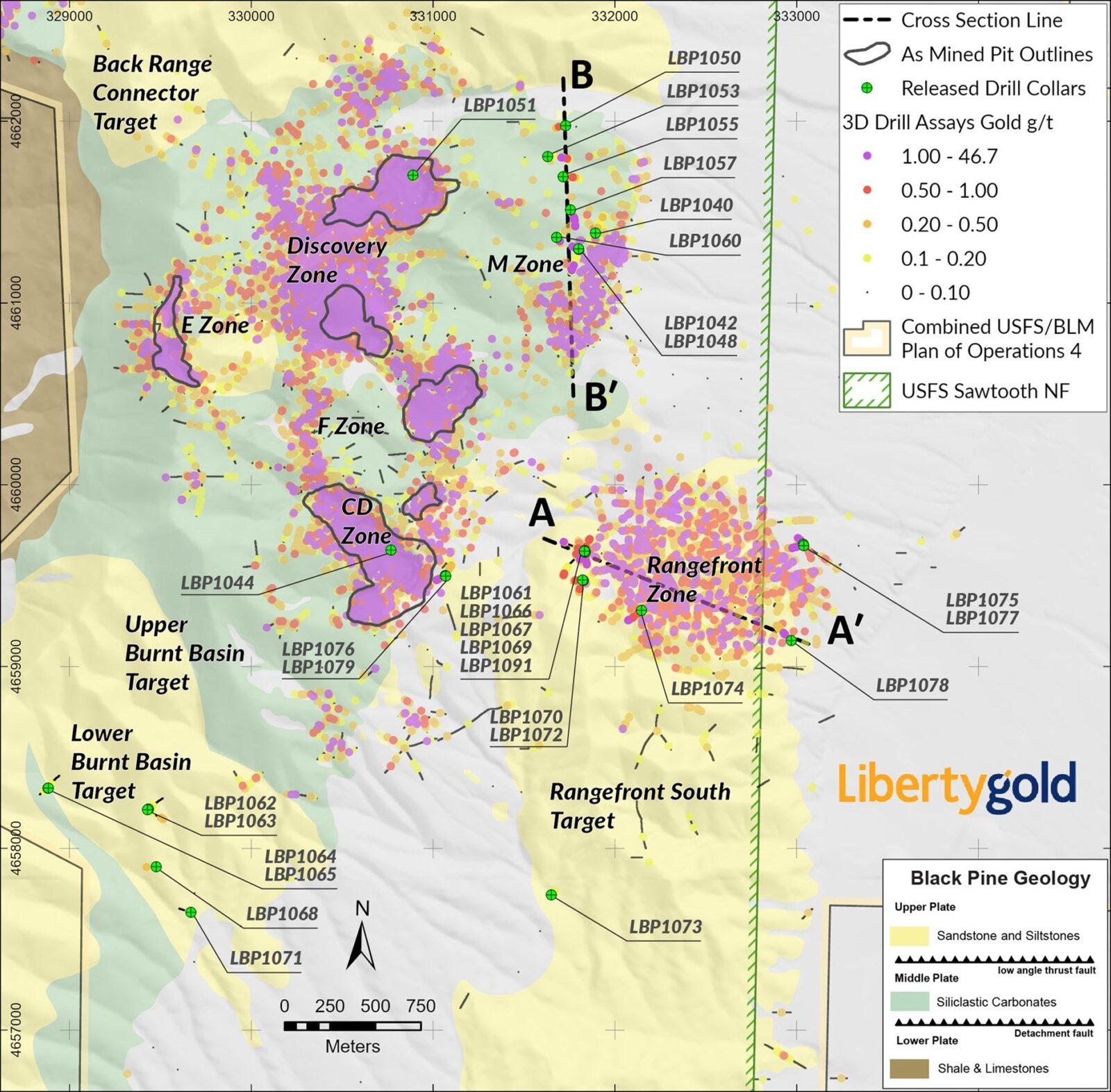
Drilling along the western margin of the Rangefront deposit continues to expand the oxide gold mineralized envelope, which now extends 230 meters (“m”) west from the current block model and 300 m west of the currently modeled resource constraining pit.
The previously announced discovery of a shallow mineralized zone in the western margin of Rangefront (see press release dated December 4, 2024) has been expanded with drill hole LBP1061 returning 21.3 m of 0.54 grams per tonne gold starting at 61 m downhole. Future drilling will be targeting this zone down dip to the east, extending back into the current resource pit, as well as to the west where it appears to come closer to surface. Addition of mineralization in this area, currently modeled as waste in the mine plan, would have a positive impact on strip ratios at Rangefront.
The near-surface oxide material on the western margin of Rangefront will be drilled out for the feasibility resource model and has the potential to feed the leach pad with early, higher-grade material. This potential early strip at Rangefront could change the economics of the deeper, high-grade zones at Rangefront and bring that mineralization forward in the production schedule. This will be evaluated in detail during the feasibility mine planning scheduled to commence in Q4 2025.
Drilling along the eastern margin of Rangefront, near the modeled pit in a large area of inferred blocks currently defined only by historic drilling, has returned a better than expected result in hole LBP1078 with a shallow oxide intercept of 24.4 m of 0.96 g/t Au including 6.1 m of 1.94 g/t Au starting at 76.2 m downhole. This result confirms the presence of higher-grade lenses of mineralization within the lower-grade inferred ounces. Such lenses can have a material impact on strip ratio which can lead to significant expansion of resource pit shells. Further drilling in the area is being planned for the 2025 resource evaluation drill program.
Five holes drilled along the north-eastern margin of Rangefront have expanded the defined inferred resource, which is still open for expansion in this direction. Highlight intercepts from this area are from hole LBP1075 with 24.4 m of 0.50 g/t Au starting at 109 m downhole. It is anticipated that this drilling will push out the resource pit slope back to the northeast opening up additional mineralization for feasibility evaluation.
FIGURE 2: M ZONE CROSS SECTION
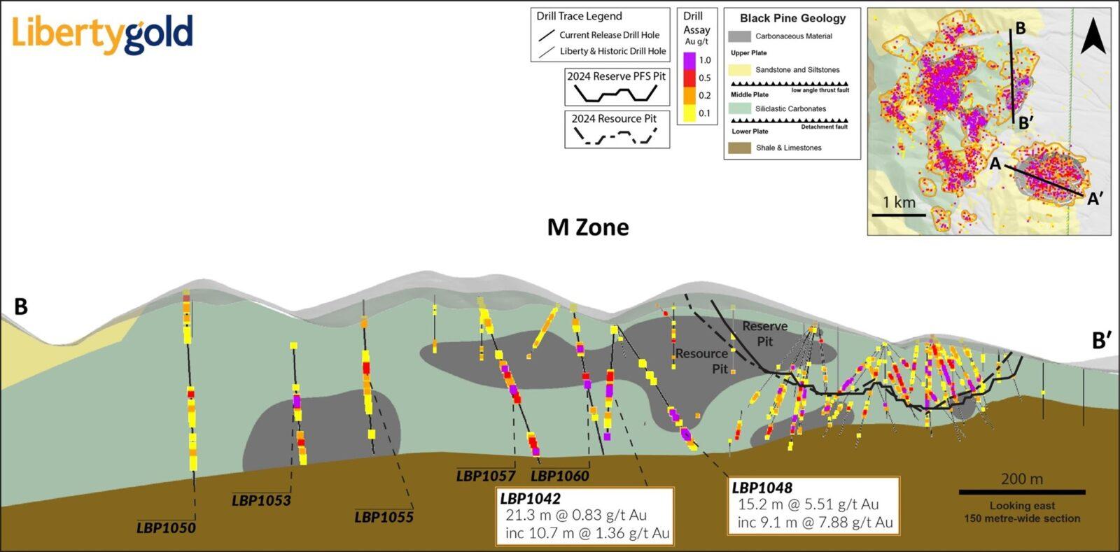
M Zone
A total of eight holes were drilled in the M Zone with the goal of expanding the mineralized zone to the west and north. All drill holes successfully hit gold mineralization including a highlight intercept in hole LBP1048 of 15.2 m of 5.51 g/t Au including 9.1 m of 7.88 g/t Au. Some of the gold intercepts hit in M Zone exhibit reduced cyanide solubility. Additional drilling and modeling are required in M Zone to fully define the potential of the resource area that currently remains open.
FIGURE 3: DRILL RESULTS MAP
CD Pit Area
Three holes were drilled in the CD pit area, including one hole drilled in the pit bottom for hydrologic testing. The two other holes were drilled along the southeastern margin of the resource, and both successfully expanded and should upgrade the defined resource. Additional drilling is needed in this area to expand the large area of inferred resource currently defined only by historic drilling. The best intercept was from hole LBP1076 which returned 19.8 m of 0.62 g/t Au.
Burnt Basin Area
Six, widely spaced exploration holes were drilled into the lower Burnt Basin target area with one hole hitting an intercept of 6.1 m of 0.28 g/t Au starting from surface. Mineralization was associated with low angle faulting and multiple intrusive dykes and sills. This indicates that the gold mineralizing system is active out to and potentially beyond the lower Burnt Basin area, located some 3.5 kilometres (“km”) from the center of the Discovery Pit. This intercept confirms the footprint of the gold system at 6.5 km x 5 km for an area exceeding 32.5 square kilometers (“km2”). The system remains open for future discovery to the north and south.
The 1 km2 upper Burnt Basin target area was not drilled in 2024 and remains as a priority target area for testing in 2025.
A Pit Drilling
A single hole was drilled in the A Pit as part of the hydrology program. This hole was notable for a gold intercept that was entirely within the lower plate and was partially oxide as defined by cyanide soluble assay ratios. The intercept in this hole (LBP1051 with 6.1 m of 0.18 g/t Au and 9.1 m of 0.24 g/t Au) was near an intercept in a historic hole (96BX-14) that had 9.1 m of 0.62 g/t Au and historic hole MGR11-007 which had an intercept of 9.1 m of 1.19 g/t Au.
Hitting mineralization deep in the lower plate is significant in that it may indicate that deep feeder zone(s) to the main mineralized area are present on the Black Pine property.
For a table showing complete drill results for the current release, see this link:
https://libertygold.ca/images/news/2025/February/BP_Intercepts02062025.pdf
QUALIFIED PERSON
Peter Shabestari, P.Geo., Vice-President Exploration, Liberty Gold, is the Company’s designated Qualified Person for this news release within the meaning of National Instrument 43-101 Standards of Disclosure for Mineral Projects and has reviewed and validated that the information contained in the release is accurate.
ABOUT LIBERTY GOLD
Liberty Gold is focused on exploring for and developing open pit oxide deposits in the Great Basin of the United States, home to large-scale gold projects that are ideal for open-pit mining. This region is one of the most prolific gold-producing regions in the world and stretches across Nevada and into Idaho and Utah. We know the Great Basin and are driven to discover and advance big gold deposits that can be mined profitably in open-pit scenarios.
Miata Metals Corp. (CSE: MMET) (FSE: 8NQ) (OTCQX: MMETF) is pleas... READ MORE
Agreement establishes a framework for social development, cultura... READ MORE
Doubleview Gold Corp. (TSX-V: DBG) (OTCQB: DBLVF) (FSE: 1D4) prov... READ MORE
Liberty Gold Corp. (TSX: LGD) (OTCQX: LGDTF) announces that it ha... READ MORE
Brunswick Exploration Inc. (TSX-V: BRW) (OTCQB: BRWXF) (FRANKFURT... READ MORE


