


Laramide Resources Ltd. (TSX: LAM) (ASX: LAM) (OTCQX: LMRXF) is pleased to announce completion of the initial diamond drilling phase of the project ramp-up at its 100% owned NRC licensed Crownpoint-Churchrock Uranium Project, near Gallup, New Mexico, USA. The diamond drill program, having a total drilled length of 6,030 feet (1,838 meters) was comprised of seven drill holes located in areas of uranium mineralization within Section 17, Township 16 North South, Range 16 West and located along the boundary between Section 17 and Section 8. Three of these drill holes were “twin holes” drilled within 20 feet (ft) of historic drill holes designed to confirm the stratigraphic position of uranium mineralization, the relative thicknesses of mineralized intervals, the range of uranium grades that were encountered in the historical drill holes and to provide drill core for chemical assays and radiometric equilibrium analysis. The project is being managed by NuFuels, Inc., a wholly owned subsidiary of Laramide Resources Ltd., which oversees Laramide’s uranium asset portfolio in the United States. As reported on December 13, 2022, and January 23, 2023, Laramide has appointed SLR International Corporation of Denver, Colorado, to complete an NI 43-101 Preliminary Economic Assessment with respect to the Churchrock Uranium Project.
Crownpoint consists of two discrete ISR-amenable deposits, Crownpoint and Churchrock, covered by a single NRC license (SUA-1580). The PEA envisions that uranium will be mined by in situ recovery methods at only the Churchrock location and recovered in a proposed new processing facility at the nearby Crownpoint location where significant project infrastructure already exists. When completed in Q2 2023, the PEA will provide estimates of project economics based on ISR mining of estimated mineral resources in Section 8 of the Churchrock NRC license area, recovery factors, and life-of-project permitting, capital, operating, and reclamation cost estimates for the mine area and the proposed Crownpoint processing facility.
The recent drilling conducted at Churchrock confirmed that historical drilling results are suitable for resource estimations and agreed with previous studies showing there is low risk of depletion of chemical uranium compared to radiometric uranium in the Churchrock mineralization, and will also provide core for the test work necessary to obtain the New Mexico Aquifer Discharge Permit, the final material permit needed for the project. Upon completion of drilling, each drill hole on the Project was logged with a suite of geophysical tools including natural-gamma, spontaneous potential (SP), and resistivity. All downhole logging was conducted by COLOG. Natural gamma logging is an industry-standard procedure for estimating equivalent uranium grades and was utilized in historic drill campaigns at Churchrock. Recovered drill core from the new holes was logged by project geologists for lithology and mineralization, and one-half splits were collected for direct geochemical analysis of uranium at Energy Laboratories, Inc. in Casper, Wyoming.
The results of the recent drilling confirmed the location and tenor of uranium roll fronts at Churchrock (Figure 2). Chemical assays of uranium were compared to recent and historic gamma-equivalent uranium grades from the Westwater Canyon B Sand (Jmw B) which was the primary target of the 2022 drill program and the primary mineralized sand targeted for ISR mining in Section 8 are shown in Table 1. Chemical assays show an average thickness of 18.3 ft of 0.061% U3O8, compared to a gamma-equivalent average thickness of 21.7 ft at 0.045% eU3O8. Comparing historic twin holes against holes completed in 2022 for equivalent grade (Table 2) showed an average thickness of 15.8 ft at 0.039% eU3O8 compared to an average thickness of 20.5 ft at 0.046% U3O8 from the nearby historic holes. Both comparisons favorably validate that the historic drilling results are suitable for declaring Mineral Resources.
From a grade thickness standpoint (grade thickness (“GT”) defined as the grade multiplied by the thickness of a mineralized intercept), all of the holes tabled below had GT’s in excess of 0.3 %-ft which is the minimum GT considered typical for mining by ISR.
Table 1: Comparison of Gamma-Indicated and Chemically-Measured Uranium in 2022 Drill Holes
| 2022 Drill Hole |
Thickness (ft) |
Gamma- Indicated U3O8 (%) |
Grade x Thickness* |
Thickness (ft) |
Chemical U3O8 (%) |
Grade x Thickness * |
| DHID-01 | 27.0 | 0.064 | 1.73 | 27.0 | 0.064 | 1.73 |
| DHID-02 | 34.3 | 0.044 | 1.49 | 22.0 | 0.058 | 1.27 |
| DHID-05 | 15.0 | 0.051 | 0.77 | 14.0 | 0.065 | 0.91 |
| DHID-06 | 25.1 | 0.036 | 0.90 | 22.5 | 0.052 | 1.17 |
| DHID-07 | 7.3 | 0.030 | 0.22 | 6.0 | 0.067 | 0.40 |
| Average | 21.7 | 0.045 | 0.98 | 18.3 | 0.061 | 1.12 |
| *Grade-Thickness is the average grade across the mineralized interval multiplied by the cumulative thickness of the mineralized interval. | ||||||
Table 2: Comparison of Gamma-Indicated and Chemically-Indicated Uranium in Twin Holes
| 2022 Drill Hole |
Thickness (ft) |
Chemical U3O8 (%) |
Grade x Thickness* |
Historic Drill Hole |
Thickness (ft) |
Gamma- Indicated U3O8 (%) |
Grade x Thickness* |
| DHID-05 | 15.0 | 0.051 | 0.77 | S17- DH51/28 |
15.5 | 0.054 | 0.84 |
| DHID-06 | 25.1 | 0.036 | 0.90 | S17- DH51/30 |
28.5 | 0.053 | 1.51 |
| DHID-07 | 7.3 | 0.030 | 0.22 | S17- DH51/32 |
17.5 | 0.032 | 0.56 |
| Average | 15.8 | 0.039 | 0.62 | 20.5 | 0.046 | 0.95 | |
| *Grade-Thickness is the average grade across the mineralized interval multiplied by the cumulative thickness of the mineralized interval. | |||||||
Mineralized core from the recently completed program will also be used by NuFuels in a planned laboratory-scale program carried out jointly with the US Department of Energy’s Los Alamos, New Mexico laboratories to demonstrate the capacity to restore groundwater geochemical conditions to levels that existed prior to uranium recovery through the application of ISR methods. The objectives for this program are as follows:
Background on Churchrock properties:
The Churchrock properties within the Crownpoint Project consist of 4,053 acres within the historic Grants Mining District in McKinley County, New Mexico. The Project is a compilation of significant historical work completed by major mining and energy companies. The United States Nuclear Regulatory Commission (NRC) has granted a license for production of uranium from sections of Churchrock.
In 2017, SLR formerly known as Roscoe Postle Associates Inc. (“RPA”) produced a Technical Report on the Churchrock properties from drill hole data available as of September 2017. Data from previous operators was consolidated and digitized resulting in a database of 1,667 drill holes totaling 1,841,545 ft of drilling. Using a 0.5 ft-% eU3O8 Grade Thickness (GT) cut-off, the Inferred Mineral Resource totals 33.9 million short tons (Mst) at an average grade of 0.08% eU3O8 for a contained metal content of 50.8 million pounds U3O8.
The current Mineral Resource is classified as Inferred based on the historic nature of the drilling data and drill hole density along mineralized trends contained within the sandstone units of the Brushy Basin and Westwater Canyon Members of the Morrison Formation.
A discharge permit for the underground injection and control associated with the Project will be required by New Mexico Water Quality Control Commission rules. Test work in support of this discharge permit is described above.
Technical information contained in this news release has been reviewed and approved by Mark B. Mathisen, C.P.G., Principal Geologist, SLR Consulting International Corp. who is considered to be a Qualified Person as defined in “National Instrument 43-101, Standards of Disclosure for Mineral Projects”.
Follow us on Twitter @LaramideRes
About Laramide Resources Ltd.:
Laramide is engaged in the exploration and development of high-quality uranium assets. Its wholly owned uranium assets are in Australia and the United States. Each of Laramide’s portfolio of five advanced uranium projects have been chosen for their production potential. Laramide’s Westmoreland project, in Queensland, Australia, is one of the largest projects currently held by a junior mining company. Its U.S. assets include Crownpoint-Churchrock Uranium Project which covers two project areas including, a large ISR project and a former uranium mining operation; La Jara Mesa in the historic Grants, New Mexico mining district; and La Sal, a fully permitted, underground project in Lisbon Valley, Utah.
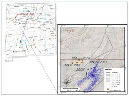
Figure 1: Location of the Crownpoint-Churchrock Uranium Project (CNW Group/Laramide Resources Ltd.)
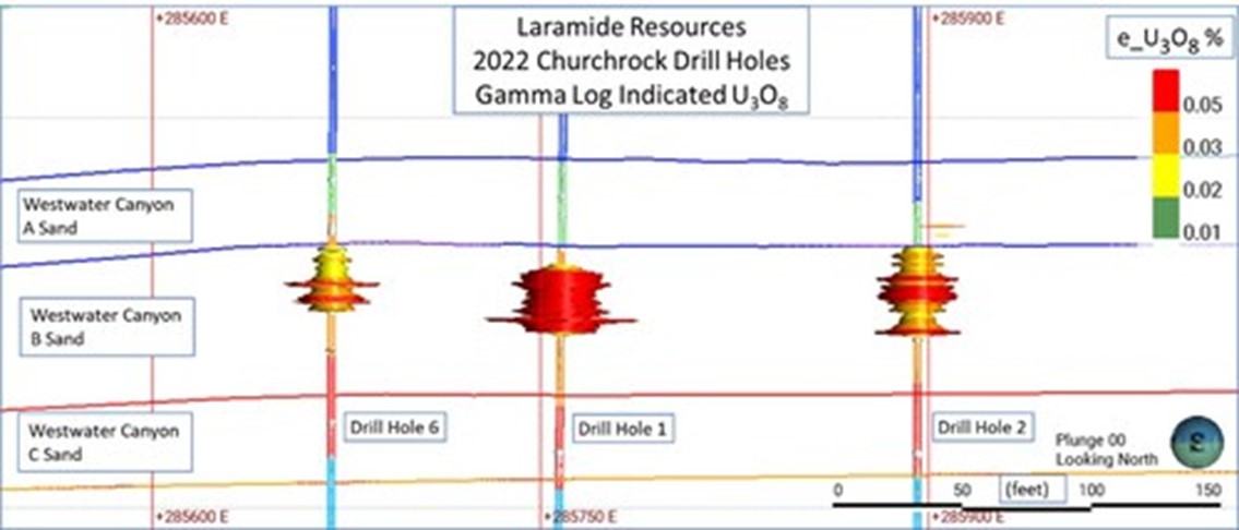
Figure 2: Gamma Indicated Westwater B Sands Intercepts in 2022 Drill Holes. (CNW Group/Laramide Resources Ltd.)
Aura Minerals Inc. (NASDAQ: AUGO) (B3: AURA33) is pleased to anno... READ MORE
GR Silver Mining Ltd. (TSX-V: GRSL) (OTCQX: GRSLF) (FRANKF... READ MORE
Empress Royalty Corp. (TSX-V: EMPR | OTCQX: EMPYF) is pleased to ... READ MORE
JZR Gold Inc. (TSX-V: JZR) (OTCPK: JZRIF) is pleased to announce ... READ MORE
Colibri Resource Corporation (TSX-V: CBI) is pleased to announce ... READ MORE


