








New results across Mirado West, North and South accompany expanded regional gold exploration priorities
Kirkland Lake Discoveries Corp. (TSX-V: KLDC) (OTCQB: KLKLF) reports new gold assay results from its KL South Project, 18 km south of Kirkland Lake, Ontario. Results include 73.86 g/t Au over 1.00 m and 36.43 g/t Au over 1.45 m at Mirado West, together with additional mineralized intersections in the Mirado North and South Zones. The drilling is enhancing our interpretation of an expanding Mirado gold-bearing footprint beyond the historical mineralized envelope.
Following the completion of a $20 million financing on October 8, 2026, the Company has commenced a 25,000-m drill program designed to evaluate extensions and continuity at Mirado while advancing selected regional gold targets across KL South.
Highlights
“These results add important high-grade intersections at Mirado West and more information on mineralization in the North and South Zones. Our priority is to determine how the gold-bearing structures extend, where they may connect and which geological features control higher-grade concentrations. With our recently completed financing, we can systematically address those questions at Mirado while testing priority regional targets across KL South,” said Stefan Sklepowicz, Chief Executive Officer.
“Big deposits have big footprints. We are growing the footprint of Mirado significantly to the West, North and South! This is a very exciting exercise and its rapidly revealing the bigger picture that is improving our scientific approach,” said Denis Laviolette, Executive Chairman.
Mirado: Testing a Broader Gold-Bearing Footprint
KLDC is testing mineralization in several distinct areas around the historical Mirado deposit. The current drill results support further investigation beyond the historical mineralized envelope, while geological continuity and the relationships between the West, North and South Zones remain to be established. Figure 1 compares the Company’s preliminary interpreted mineralized footprint with the historical envelope; interpreted outlines are exploration models, not measured mineral resources.
Based on the current preliminary model, the interpreted footprint spans approximately 1,300 by 930 m horizontal and 550 m vertically, compared with a historical interpreted footprint of approximately 740 by 380 m horizontal and 380 m vertically. These dimensions do not represent a mineral resource estimate or establish continuity throughout the area.
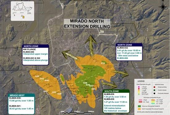
Figure 1 – Plan view of Mirado showing 2026 drill-hole locations and assay composites, the historical mineralized envelope, and KLDC’s preliminary interpreted footprint. Interpreted areas are not established mineral resource boundaries.
Mirado West: High-grade intersections warrant follow-up
Hole KLM26-039 returned 73.86 g/t Au over 1.00 m from 219.00 m downhole, and KLM26-041 returned 36.43 g/t Au over 1.45 m from 40.55 m downhole. The two holes were drilled 100 m south of KLM26-035 and KLM26-037, from the same collar area in opposite directions. Early drilling at Mirado West has encountered localized high-grade gold and broader lower-grade intervals (Table 1) and remains a high priority for drilling.
Current drilling is evaluating the orientation and extent of the mineralized structures and the area between the West and North Zones. Further work is required to determine continuity between individual high-grade intersections and the potential relationship of these structures to the broader Mirado system.
Mirado North: Additional mineralization along interpreted stacked structures
Hole KLM26-032 intersected 2.01 g/t Au over 19.00 m from 146.00 m downhole, including 11.22 g/t Au over 3.00 m. The hole was drilled approximately 50 m west of, and beneath, KLM26-006, adding information on the lateral and vertical distribution of gold-bearing structures. The broad composite includes lower-grade material outside the higher-grade interval.
On the current geological interpretation, KLM26-040 may have intersected the upper part of a northwest-plunging structural trend, while KLM26-043 and KLM26-044 may have passed above the projected mineralized plunge. These three holes returned no significant values under the reporting criteria. Further down-plunge drilling is planned to confirm this interpretation.
Mirado South: Evaluating depth extensions
In a sparsely drilled area between the established North and South Zones, KLM26-036 returned 7.36 g/t Au over 3.50 m from 257.00 m downhole and KLM26-038 returned 1.27 g/t Au over 11.00 m from 81.00 m downhole. Additional lower-grade intersections were recorded in both holes.
Taken together, South Zone drilling is interpreted to have encountered mineralization approximately 120 m below the historical mineralized envelope. The intersections provide follow-up targets, but additional drilling is needed to define the geometry, grade distribution and continuity of mineralization at depth.
Table 1 – Mirado drill assay results
| DRILL HOLE | FROM (M) | TO (M) | INTERVAL (M) | Au (g/t) | ZONE |
| KLM26-032 | 45.40 | 47.90 | 2.50 | 2.11 | Mirado North Zone |
| 146.00 | 165.00 | 19.00 | 2.01 | Mirado North Zone | |
| including | 157.00 | 160.00 | 3.00 | 11.22 | Mirado North Zone |
| KLM26-032 | 186.00 | 215.00 | 29.00 | 0.33 | Mirado North Zone |
| KLM26-033 | 70.00 | 72.00 | 2.00 | 1.04 | Mirado South Zone |
| KLM26-034 | NSV | Mirado South Zone | |||
| KLM26-036 | 22.00 | 36.00 | 14.00 | 0.62 | Mirado South Zone |
| 120.00 | 159.00 | 39.00 | 0.50 | Mirado South Zone | |
| 257.00 | 260.50 | 3.50 | 7.36 | Mirado South Zone | |
| KLM26-038 | 81.00 | 92.00 | 11.00 | 1.27 | Mirado South Zone |
| 141.50 | 158.00 | 16.50 | 0.59 | Mirado South Zone | |
| 279.00 | 280.00 | 1.00 | 1.54 | Mirado South Zone | |
| 375.00 | 378.00 | 3.00 | 1.11 | Mirado South Zone | |
| KLM26-039 | 219.00 | 220.00 | 1.00 | 73.86 | Mirado West Zone |
| KLM26-040 | NSV | Mirado North Zone | |||
| KLM26-041 | 40.55 | 42.00 | 1.45 | 36.43 | Mirado West Zone |
| KLM26-042 | 275.00 | 276.48 | 1.48 | 0.78 | Mirado West Zone |
| 322.00 | 337.00 | 15.00 | 0.23 | Mirado West Zone | |
| KLM26-043 | NSV | Mirado North Zone | |||
| KLM26-044 | NSV | Mirado North Zone | |||
| KLM26-046 | 19.00 | 27.00 | 8.00 | 0.35 | Mirado West Zone |
| 67.84 | 68.20 | 0.36 | 4.84 | Mirado West Zone | |
| 153.00 | 160.73 | 7.73 | 0.36 | Mirado West Zone | |
| KLM26-047 | 189.00 | 190.00 | 1.00 | 1.98 | Mirado West Zone |
| 211.00 | 224.00 | 13.00 | 0.40 | Mirado West Zone | |
| 312.00 | 313.00 | 1.00 | 2.65 | Mirado West Zone | |
| KLM26-049 | 128.00 | 129.00 | 1.00 | 1.16 | Mirado West Zone |
| Note: NSV = no significant values. Reported composites are calculated using a nominal 0.2 g/t Au cutoff and may include internal dilution; see Data Verification & Quality Assurance/Quality Control (QA/QC). | |||||
Funded to Advance Mirado and Test Regional Targets
KLDC has commenced a minimum 25,000-m drill campaign following the $20 million financing completed on October 8, 2026. The program is intended to balance near-deposit drilling with the evaluation of new regional gold targets, with priorities refined as assays and geological interpretations become available.
The current program calls for approximately 15,000 m of drilling at Mirado and 10,000 m on regional targets. As of this release, two rigs are operating and assays are pending for 23 completed holes, including seven holes drilled on regional targets. The anticipated timing of drill-result updates is every 3-4 weeks on an ongoing basis.
At Mirado, drilling will focus on testing continuity of high-grade structures, step-outs from the interpreted envelope and the relationship between the West, North and South Zones. Beyond Mirado, the Company is preparing to evaluate targets defined by gold-grain-in-till anomalies, geophysical interpretations, prospecting and historical mining records.
Regional Exploration: Multiple Targets Beyond Mirado
Charest and Till Anomaly
Northwest of Mirado, an approximately 1.2-km trend of elevated gold-grain counts in glacial till includes a sample returning 235 gold grains. The trend extends down-ice from a cross-cutting structure interpreted from geophysical data. Prospecting and structural interpretation are being used to evaluate potential bedrock sources up-ice of the till anomaly ahead of drilling.
Survey-background grain counts are typically in the 1-10 range, and sampling density is based on regional spacing of 200 m where valid ground would support till sampling. The presently reported gold-grain counts are preliminary and unnormalized. Counts are exploration indicators only and are not equivalent to gold grades in bedrock.
Gold Hill and Mirado North Extension
South of Mirado, the historical Gold Hill Mine reported production of 660 oz of gold during 1927-1928 (Ontario Mineral Deposit Inventory reference 31M13NW00006). Its location near the regional Catharine Fault, together with historically documented gold-bearing veins and interpreted structural offsets, provides a rationale for testing beyond the former workings. Historical information has not been independently verified by the Company.
At Mirado North Extension, follow-up exploration is assessing structural breaks interpreted from geophysical data and areas up-ice of a till sample that returned 145 gold grains. The bedrock sources of the gold grains, and any geological connections among regional prospects or with Mirado, have not yet been established.
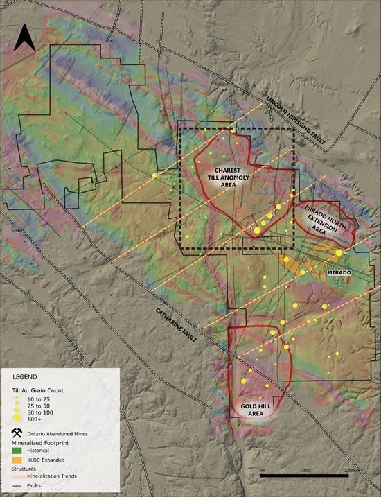
Figure 2 – KL South regional exploration areas, including Charest and Till Anomaly and Gold Hill. Outlined areas represent exploration priorities, not defined mineralized zones. Drilling allocations shown are preliminary and may change as the program advances.
A Geological Model to Guide the Next Drill Holes
The Company is combining gold assays, geological logging, multi-element geochemistry and hyperspectral mineral identification in a three-dimensional litho-structural model to better constrain gold-bearing structures and prioritize drilling. Hyperspectral work completed by LithologIQ indicates differing alteration characteristics between examined North and South Zone holes.
North Zone hole KLM26-030 shows stronger muscovite responses associated with stacked mineralized shear structures, while South Zone hole KLM26-011 shows broad silicification and commonly phengitic white-mica signatures. These observations are being evaluated as potential vectors toward favourable geological settings (Figure 3).
The relationships among alteration, structures and gold mineralization are preliminary. Contrasting spectral signatures do not independently establish separate mineralizing events or mineral grades, and alternative explanations include host-rock effects and variation within a single mineralizing system. The intended application is to refine drilling targets and identify possible near misses that merit testing.
KLM26-011 – View the High-Resolution Hyperspectral Core Scan
KLM26-030 – View the High-Resolution Hyperspectral Core Scan
Figure 3 – Hyperspectral strip logs for Mirado South hole KLM26-011 and Mirado North hole KLM26-030. The observations assist alteration mapping and drill targeting but do not independently demonstrate mineralization continuity.
Digital Resources
Stakeholders can explore KLDC’s drilling through a publicly accessible interactive 3D model hosted by Mining Hub, which illustrates drill-hole data, mineralized intervals and interpreted target areas. The latest episode of KLDC’s Treasure Hunters video series features Ben Cleland, VP Exploration, reviewing this news release and providing a more in-depth exploration outlook.
Data Verification & Quality Assurance/Quality Control
Gold analyses were completed on half-core NQ samples at Paragon Geochemical Laboratory (independent of KLDC) using Chrysos PhotonAssay technology. PhotonAssay is a non-destructive method that uses high-energy X-rays to measure gold in large samples of approximately 500 g, reducing sampling variability associated with coarse gold mineralization and allowing the retained material to remain available for additional analysis.
Table 2 – Paragon Sample Preparation and Analytical Methods
| Analysis | Code | Location |
| Preparation | PREP-PKG | Timmins, Ontario, Canada |
| Photon and Fire Assay | PA-AU01, Au-SCR1K | Surrey, British Columbia | Hamilton, Ontario, Canada |
| Multi-Element | 33MA-OES | Sparks, Nevada, USA |
Samples returning gold values above the 350 g/t upper detection limit of the PhotonAssay method are reanalyzed using a 1 kg screen fire assay. The sample is sieved at 110 microns, the coarse fraction is analyzed gravimetrically, and the fine fraction is analyzed in duplicate by AAS; the combined result provides a representative total gold value for samples that may contain coarse gold.
Drill program design, QA/QC and interpretation of results are conducted by qualified persons consistent with National Instrument 43-101 and industry best practices. Certified reference standards and blanks are inserted into the sample stream at regular intervals, approximately one control sample per twenty samples, to monitor analytical accuracy and precision.
Reported intervals are calculated using length-weighted average grades with a nominal 0.2 g/t Au cutoff. To reflect continuity within the broader mineralized system, up to 6.9 m of consecutive internal dilution below cutoff is included within selected composites. Reported assays are uncut and no top cut has been applied. All intervals are reported as downhole core lengths. True widths at Mirado are estimated at approximately 80% of reported core lengths.
Qualified Person
The technical information contained in this news release has been reviewed and approved by Benjamin Cleland, P.Geo., Vice-President, Exploration, who is a Qualified Person as defined by National Instrument 43-101 – Standards of Disclosure for Mineral Projects.
About Kirkland Lake Discoveries Corp.
Kirkland Lake Discoveries Corp. has assembled a 420 km2 exploration portfolio in the Kirkland Lake region of Ontario’s Abitibi Greenstone Belt, one of the most prolific mining districts in the world. The Company’s properties span key fault zones, geophysical anomalies and volcanic-sedimentary contacts within the Blake River Group, a highly prospective assemblage known to host both gold and polymetallic massive-sulphide deposits.
With exploration permits in place, KLDC is positioned to advance a pipeline of drill-ready targets at KL South, KL West and KL East, supported by anomalous soil trends, historical mineral showings and structurally controlled intersections.
K2 Gold Corporation (TSX-V: KTO) (OTCQX: KTGDF) (FSE: 23K) announ... READ MORE
Labrador Gold Corp. (TSX-V: LAB) (FNR: 2N6) is pleased to announce the c... READ MORE
BP Silver Corp. (TSX-V: BPAG) (OTCQB: BPSCF) announces new ass... READ MORE
White Gold Corp. (TSX-V: WGO) (OTCQX: WHGOF) (FSE: 29W) is please... READ MORE