


IsoEnergy Ltd. (TSX-V: ISO) (OTCQX: ISENF) is pleased to report additional intersections of strong radioactivity from the on-going drilling program at the Hurricane zone. The Hurricane zone is a recent discovery of high-grade uranium mineralization on the Company’s 100% owned Larocque East property in the Eastern Athabasca Basin of Saskatchewan (Figure 1).
Highlights:
Craig Parry, Chief Executive Officer commented: “Following up on the very high-grade assays released earlier this week, I’m pleased to report that IsoEnergy continues to deliver outstanding uranium intersections at the Hurricane zone, just 320m below surface.”
Steve Blower, Vice President of Exploration commented: “The southern extension drill holes completed to date have expanded the footprint of the intensely mineralized portion of the Hurricane zone. We will continue to evaluate this area with the five remaining drill holes in the program.”
LE20-68 (Section 4485E)
Completed to evaluate the potential to expand mineralization south on section 4485E (Figures 2 and 3), drill hole LE20-68 successfully intersected 11.0m of uranium mineralization (>500 CPS) from 323.0 to 334.0m, including a subinterval of very strong radioactivity (>50,000 CPS) from 332.0 to 333.5m. This result increases the width of the zone on this section by at least 10m. As with all drill holes to date at the Hurricane zone, the mineralization is located at the sub-Athabasca unconformity.
LE20-69 (Section 4435E)
Designed to follow-up on the intense uranium mineralization intersected previously in drill hole LE20-64 on section 4435E, LE20-69 was completed 8m southeast of LE20-64 (Figures 2 and 4). It intersected 6.5m of uranium mineralization (>500 CPS) from 322.5m to 329.0m, including 1.0m of strong mineralization (>5,000 CPS) from 325.0 to 326.0m. This result expands the Hurricane zone footprint at least 8m south of drill hole LE20-64 on this section, and summer drilling has now expanded the zone a total of 38m to the south.
LE20-72 (Section 4460E)
Drill hole LE20-72 (Figures 2 and 5) was designed to evaluate the potential to extend mineralization south on section 4460E. It intersected 6.0m of uranium mineralization (>500 CPS) from 320.5 to 326.5m, including 1.5m of very strong mineralization (>40,000 CPS) from 324.5 to 326.0m. This result expands the Hurricane zone footprint at least 10m south on this section.
Other Drill Holes
Drill holes LE20-70 and LE20-71 were completed on the south end of sections 4560E and 4485E, respectively (Figures 2 and 3). Drill hole LE20-71 intersected 2.0m of uranium mineralization (>500 CPS) from 327.5 to 329.5m, including 0.5m of strong uranium mineralization (>20,000 CPS), 16m south of drill hole LE20-68. Drill hole LE20-70, located 18m south of LE19-03 on the discovery section 4560E was not significantly mineralized.
Next Steps
Five drill holes remain in this expanded drill program. All will be completed on the western end of the Hurricane zone. Samples are periodically shipped to the analytical laboratory in Saskatoon. Chemical assay results generally follow within three to four weeks of the shipping dates.
The Larocque East Property and the Hurricane Zone
The 100% owned Larocque East property consists of 31 mineral claims totaling 15,878ha that are not encumbered by any royalties or other interests. Larocque East is immediately adjacent to the north end of IsoEnergy’s Geiger property and is 35km northwest of Orano Canada’s McClean Lake uranium mine and mill.
Along with other target areas, the Property covers a 15-kilometre-long northeast extension of the Larocque Lake conductor system; a trend of graphitic metasedimentary basement rocks that is associated with significant uranium mineralization at the Hurricane zone, and in several occurrences on Cameco Corp. and Orano Canada Inc.’s neighbouring property to the southwest of Larocque East. The Hurricane zone was discovered in July 2018 and was followed up with 29 drill holes in 2019 and an additional 14 drill holes to date in 2020. Dimensions are currently 575m along-strike, 40m wide, and up to 11m thick. The zone is open for expansion along-strike to the east and on most sections. Mineralization is polymetallic and commonly straddles the sub-Athabasca unconformity 320 m below surface. The best intersection to date is 33.9% U3O8 over 8.5m in drill hole LE20-34. Drilling at Cameco Corp.’s Larocque Lake zone on the neighbouring property to the southwest has returned historical intersections of up to 29.9% U3O8 over 7.0m in drill hole Q22-040. Like the nearby Geiger property, Larocque East is located adjacent to the Wollaston-Mudjatik transition zone – a major crustal suture related to most of the uranium deposits in the eastern Athabasca Basin. Importantly, the sandstone cover on the Property is thin, ranging between 140m and 330m in previous drilling.
Table 1 – Summer 2020 Drilling Program Results
| Hole-ID | From (m) | To (m) | Length (m) | Radioactivity1,2 | Chemical Assays | Orientation | Location | |
| (CPS) | U3O8 (%) | Ni (%) | (Azm/Dip) | |||||
| LE20-544 | 329.5 | 338.5 | 9.0 | >500 | 12.8 | 3.9 | 180/-79 | Sect 4510E |
| incl. | 333.0 | 337.0 | 4.0 | >30,000 | 27.1 | 5.2 | ||
| incl. | 334.0 | 334.5 | 0.5 | Off-scale5 | 52.5 | 1.6 | ||
| LE20-554 | No significant mineralization | 180/-70 | Sect 4785E | |||||
| LE20-564 | 351.0 | 358.5 | 7.5 | >500 | 0.1 | 0.1 | 180/-70 | Sect 4660E |
| LE20-574 | 343.8 | 353.8 | 10.0 | >500 | 11.7 | 0.3 | 217/-70 | Sect 4435E |
| incl. | 347.3 | 349.8 | 2.5 | >40,000 | 46.0 | 1.0 | ||
| incl. | 347.8 | 348.3 | 0.5 | Off-scale5 | 65.9 | 0.7 | ||
| LE20-58 | Abandoned before target | 180/-69 | Sect 4785E | |||||
| LE20-58C14,6 | 144.0 | 146.5 | 2.5 | >500 | 0.2 | 0.1 | 180/-71 | Sect 4785E |
| LE20-594 | 342.0 | 347.0 | 5.0 | >500 | 0.2 | 0.2 | 112/-69 | Sect 4610E |
| incl. | 345.0 | 345.5 | 0.5 | >5,000 | 0.9 | 0.2 | ||
| LE20-60 | No significant mineralization | 000/-90 | Sect 4660E | |||||
| LE20-614 | 313.0 | 322.0 | 9.0 | >500 | 0.3 | 0.0 | 000/-90 | Sect 4660E |
| incl. | 321.5 | 322.0 | 0.5 | >10,000 | 1.4 | 0.2 | ||
| LE20-624 | 314.0 | 316.5 | 2.5 | >500 | 0.2 | 0.0 | 000/-90 | Sect 4435E |
| and | 321.0 | 325.5 | 4.5 | >500 | 6.2 | 0.5 | ||
| incl. | 323.0 | 325.5 | 2.5 | >30,000 | 11.1 | 0.3 | ||
| incl. | 324.5 | 325.0 | 0.5 | Off-scale5 | 29.0 | 0.3 | ||
| LE20-63A | No significant mineralization | 180/-85 | Sect 4660E | |||||
| LE20-644 | 316.5 | 320.0 | 3.5 | >500 | 0.3 | 0.1 | 000/-90 | Sect 4435E |
| and | 324.0 | 329.0 | 5.0 | >500 | 48.8 | 1.1 | ||
| incl. | 324.5 | 328.5 | 4.0 | >30,000 | 57.5 | 1.3 | ||
| LE20-65 | No significant mineralization | 000/-90 | Sect 4610E | |||||
| LE20-664 | 323.0 | 324.0 | 1.0 | >500 | Pending | 000/-90 | Sect 4785E | |
| LE20-674 | 327.5 | 329.5 | 2.0 | >500 | Pending | 000/-90 | Sect 4435E | |
| LE20-68 | 323.0 | 334.0 | 11.0 | >500 | Pending | 180/-80 | Sect 4485E | |
| incl. | 332.0 | 333.5 | 1.5 | >50,000 | ||||
| LE20-69 | 322.5 | 329.0 | 6.5 | >500 | Pending | 000/-90 | Sect 4435E | |
| incl. | 325.0 | 326.0 | 1.0 | >5,000 | ||||
| LE20-70 | No significant mineralization | 000/-90 | Sect 4560E | |||||
| LE20-71 | 324.0 | 325.0 | 1.0 | >500 | Pending | 000/-90 | Sect 4485E | |
| and | 327.5 | 329.5 | 2.0 | >500 | ||||
| incl. | 329.0 | 329.5 | 0.5 | >20,000 | ||||
| LE20-72 | 320.5 | 326.5 | 6.0 | >500 | Pending | 000/-90 | Sect 4460E | |
| incl. | 323.0 | 323.5 | 0.5 | >20,000 | ||||
| and incl. | 324.5 | 326.0 | 1.5 | >40,000 | ||||
| Notes: | 1. | Radioactivity is total gamma from drill core measured with an RS-125 hand-held spectrometer |
| 2. | Measurements of total gamma on drill core are an indication of uranium content, but may not correlate with chemical assays | |
| 3. | Radioactivity previously disclosed | |
| 4. | Radioactivity and chemical assays previously disclosed | |
| 5. | Off-scale radioactivity is defined as exceeding 65,536 cps, the maximum measurable by an RS-125 spectrometer | |
| 6. | LE20-58C1 is a wedged off-cut from LE20-58 at 200m |
Qualified Person Statement
The scientific and technical information contained in this news release was prepared by Andy Carmichael, P.Geo., IsoEnergy’s Senior Geologist, who is a “Qualified Person” (as defined in NI 43-101 – Standards of Disclosure for Mineral Projects). Mr. Carmichael has verified the data disclosed. All radioactivity measurements reported herein are total gamma from an RS-125 hand-held spectrometer. As mineralized drill holes at the Hurricane zone are oriented very steeply (-70 to -90 degrees) into a zone of mineralization that is interpreted to be horizontal, the true thickness of the intersections is expected to be greater than or equal to 90% of the core lengths. This news release refers to properties other than those in which the Company has an interest. Mineralization on those other properties is not necessarily indicative of mineralization on the Company’s properties. All chemical analyses are completed for the Company by SRC Geoanalytical Laboratories in Saskatoon, SK. For additional information regarding the Company’s Larocque East Project, including its quality assurance and quality control procedures, please see the Technical Report dated effective May 15, 2019, on the Company’s profile at www.sedar.com.
About IsoEnergy
IsoEnergy is a well-funded uranium exploration and development company with a portfolio of prospective projects in the eastern Athabasca Basin in Saskatchewan, Canada. The Company recently discovered the high-grade Hurricane Zone of uranium mineralization on its 100% owned Larocque East property in the Eastern Athabasca Basin. IsoEnergy is led by a Board and Management team with a track record of success in uranium exploration, development and operations. The Company was founded and is supported by the team at its major shareholder, NexGen Energy Ltd.

Figure 1 – Larocque East Property Map (CNW Group/IsoEnergy Ltd.)
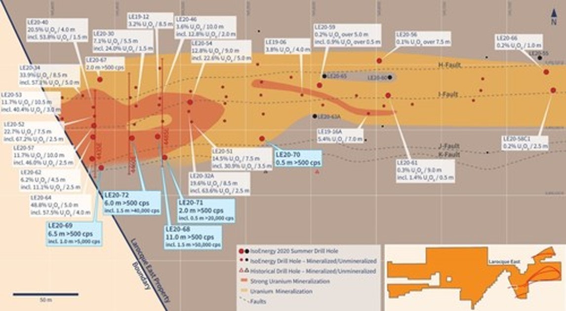
Figure 2 – Hurricane Zone Drill Hole Location Map (CNW Group/IsoEnergy Ltd.)
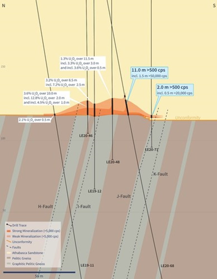
Figure 3 – Vertical Cross-Section 4485E (Drill Holes LE20-68 and 71) (CNW Group/IsoEnergy Ltd.)

Figure 4 – Vertical Cross-Section 4435E (Drill Hole LE20-69) (CNW Group/IsoEnergy Ltd.)
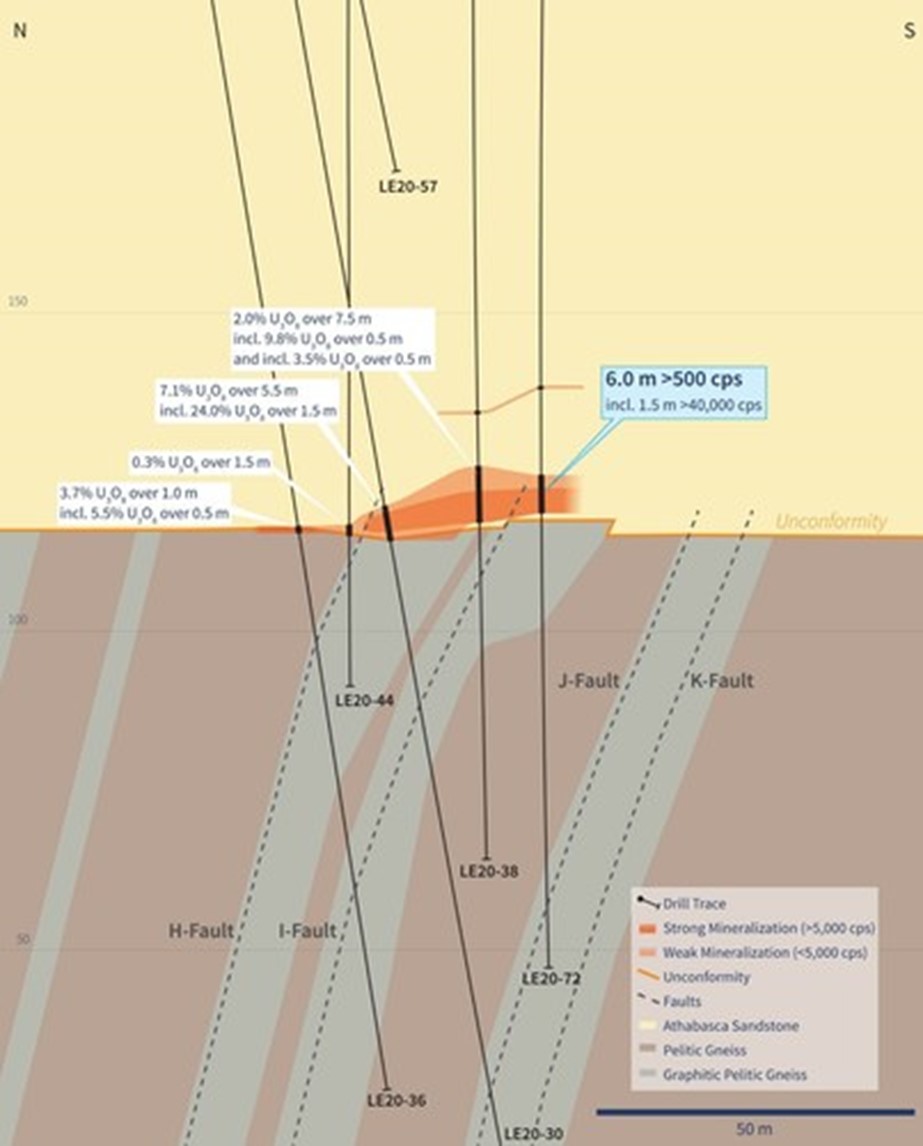
Figure 5 – Vertical Cross-Section 4460E (Drill Hole LE20-72) (CNW Group/IsoEnergy Ltd.)
Silver Mountain Resources Inc. (TSX-V: AGMR) (OTCQB: AGMRF) is ... READ MORE
Mandalay Resources Corporation (TSX: MND) (OTCQB: MNDJF) announce... READ MORE
Collective Mining Ltd. (TSX: CNL) (OTCQX: CNLMF) (FSE: GG1) is pl... READ MORE
Significant copper and molybdenum intersections include: HM19: 11... READ MORE
Red Pine Exploration Inc. (TSX-V: RPX) (OTCQB: RDEXF) is pleased ... READ MORE


