








Intrepid Metals Corp. (TSX-V: INTR) (OTCQB: IMTCF) is pleased to provide assay results assay results from two additional diamond drill holes from the Ringo Zone, part of the ongoing 2025 drill campaign at the Company’s flagship Corral Copper Property in Cochise County, Arizona (see Figure 1 below). Assay results for the final 4 holes of the 2025 drill program are pending.
“With every new round of results, we’re not only advancing the geological understanding of Corral but also strengthening Intrepid’s strategic position in the copper sector,” said Mark Morabito, Chairman and CEO of Intrepid Metals. “The growing scale of the system reinforces our view that Corral represents a rare opportunity to deliver meaningful value for shareholders and attract the attention of major industry players.”
Highlights from Holes CC25_041 and CC25_042:
CC25_041:
CC25_042:
Technical Information
All scientific and technical information in this news release has been reviewed and approved by Daniel MacNeil, P.Geo. Mr. MacNeil is a Technical Advisor to the Company and is a qualified person for the purposes of National Instrument 43-101 – Standards of Disclosure for Mineral Projects.
Mr. MacNeil has verified the drilling data disclosed in this news release, including the assay and test data underlying the information or opinions contained in this news release. Mr. MacNeil verified the data disclosed (including previously released Intrepid data underlying the information disclosed) in this news release by reviewing imported and sorted assay data; checking the performance of blank samples and certified reference materials; reviewing the variance in field duplicate results; and reviewing grade calculation formulas. Mr. MacNeil detected no significant QA/QC issues during review of the data and is not aware of any sampling, recovery or other factors that could materially affect the accuracy or reliability of the drilling data referred to in this news release.
As it relates to adjacent properties disclosed in this news release, Mr. MacNeil has been unable to verify the information and that the information is not necessarily indicative to the mineralization on the Corral Copper Property.
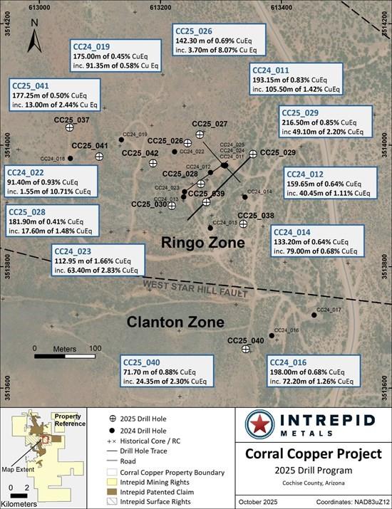
Figure 1: Drill plan map from the Ringo Zone at Corral Copper
Table 1: Drill Intercepts for the Ringo Zone1
| CC25_038 & CC25_039 COMPOSITE INTERCEPTS | |||||||||
| DRILL HOLE DETAILS | ANALYZED GRADE | DILUTED METAL EQUIVALENT1 |
|||||||
| DRILL HOLE | FROM | TO | LENGTH | COPPER | GOLD | SILVER | ZINC | CUEQ | AUEQ |
| ID | (m) | (m) | (m) | (%) | (ppm) | (ppm) | (%) | (%) | (ppm) |
| CC25_041 | 25.00 | 26.50 | 1.50 | 0.113 | 0.005 | 0.500 | 0.001 | 0.110 | 0.090 |
| CC25_041 | 30.55 | 40.85 | 10.30 | 0.440 | 0.021 | 0.811 | 0.031 | 0.410 | 0.340 |
| CC25_041 | 58.35 | 63.70 | 5.35 | 0.229 | 0.085 | 0.781 | 0.055 | 0.300 | 0.250 |
| CC25_041 | 65.00 | 67.50 | 2.50 | 0.065 | 0.092 | 1.377 | 0.059 | 0.180 | 0.140 |
| CC25_041 | 117.50 | 294.75 | 177.25 | 0.413 | 0.195 | 2.524 | 0.034 | 0.580 | 0.480 |
| Incl. | 164.50 | 294.75 | 130.25 | 0.517 | 0.213 | 2.800 | 0.041 | 0.690 | 0.570 |
| And | 247.00 | 260.00 | 13.00 | 2.199 | 0.838 | 4.458 | 0.068 | 2.760 | 2.260 |
| CC25_042 | 11.50 | 13.00 | 1.50 | 0.094 | 0.015 | 1.300 | 0.001 | 0.110 | 0.090 |
| CC25_042 | 26.90 | 32.50 | 5.60 | 0.118 | 0.017 | 0.411 | 0.002 | 0.120 | 0.100 |
| CC25_042 | 50.50 | 56.50 | 6.00 | 0.194 | 0.020 | 0.975 | 0.021 | 0.200 | 0.160 |
| CC25_042 | 76.00 | 153.60 | 77.60 | 0.182 | 0.098 | 1.580 | 0.141 | 0.310 | 0.250 |
| Incl. | 79.00 | 105.50 | 26.50 | 0.250 | 0.173 | 1.131 | 0.252 | 0.460 | 0.380 |
| CC25_042 | 167.90 | 171.00 | 3.10 | 0.080 | 0.081 | 2.403 | 0.017 | 0.180 | 0.150 |
| CC25_042 | 178.50 | 226.35 | 47.85 | 0.334 | 0.273 | 3.995 | 0.128 | 0.630 | 0.520 |
| Incl. | 178.50 | 185.55 | 7.05 | 0.494 | 0.733 | 2.972 | 0.009 | 1.180 | 0.960 |
| And | 215.00 | 226.35 | 11.35 | 0.982 | 0.354 | 7.399 | 0.153 | 1.310 | 1.070 |
| CC25_042 | 245.95 | 247.80 | 1.85 | 0.294 | 0.142 | 3.978 | 0.051 | 0.450 | 0.370 |
Table 2: Drill Hole Location Information for all holes drilled in 2025
| DRILL | START | END | EASTING | NORTHING | ELEVATION | AZIMUTH | INCLINATION | DEPTH |
| HOLE | DATE | DATE | (m) | (m) | (m) | (°) | (°) | (m) |
| CC25_026 | 2025-04-28 | 2025-05-03 | 613245 | 3514003 | 1424 | 0 | -90 | 234.4 |
| CC25_027 | 2025-05-04 | 2025-05-08 | 613265 | 3514017 | 1423 | 0 | -90 | 224.65 |
| CC25_028 | 2025-05-09 | 2025-05-16 | 613267 | 3513936 | 1420 | 0 | -90 | 240.8 |
| CC25_029 | 2025-05-17 | 2025-05-23 | 613353 | 3513985 | 1415 | 225 | -60 | 305.1 |
| CC25_030 | 2025-05-24 | 2025-05-30 | 613219 | 3513900 | 1423 | 0 | -90 | 270.7 |
| CC25_031 | 2025-05-31 | 2025-06-06 | 611891 | 3515918 | 1501 | 235 | -40 | 320.65 |
| CC25_032 | 2025-06-07 | 2025-06-12 | 612028 | 3515934 | 1472 | 0 | -90 | 313.05 |
| CC25_033 | 2025-06-12 | 2025-06-17 | 612135 | 3515757 | 1485 | 235 | -80 | 230.1 |
| CC25_034 | 2025-06-18 | 2025-06-22 | 612169 | 3514840 | 1495 | 250 | -45 | 204.2 |
| CC25_035 | 2025-06-22 | 2025-06-29 | 612258 | 3514776 | 1494 | 245 | -50 | 249.95 |
| CC25_036 | 2025-06-30 | 2025-07-06 | 612177 | 3514898 | 1497 | 250 | -50 | 219.6 |
| CC25_037 | 2025-07-07 | 2025-07-18 | 613050 | 3514029 | 1435 | 0 | -90 | 334.65 |
| CC25_038 | 2025-07-19 | 2025-07-29 | 613337 | 3513870 | 1422 | 0 | -90 | 282.55 |
| CC25_039 | 2025-07-30 | 2025-08-09 | 613276 | 3513906 | 1420 | 0 | -90 | 255.75 |
| CC25_040 | 2025-08-10 | 2025-08-22 | 613341 | 3513664 | 1438 | 0 | -90 | 331.30 |
| CC25_041 | 2025-08-23 | 2025-08-27 | 613099 | 3513981 | 1428 | 0 | -90 | 310.00 |
| CC25_042 | 2025-08-28 | 2025-09-02 | 613188 | 3513970 | 1425 | 0 | -90 | 274.90 |
| CC25_043 | 2025-09-03 | 2025-09-10 | 613305 | 3514040 | 1420 | 0 | -90 | 212.15 |
| CC25_044 | 2025-09-11 | 2025-09-15 | 613156 | 3513936 | 1425 | 0 | -90 | 290.15 |
| CC25_045 | 2025-09-15 | 2025-09-22 | 614067 | 3513972 | 1411 | 215 | -70 | 391.05 |
| CC25_046 | 2025-09-23 | 2025-09-27 | 613206 | 3513935 | 1423 | 0 | -90 | 269.75 |
Quality Assurance and Quality Control
Drill core was first reviewed by a geologist, who identified and marked intervals for sampling. The marked sample intervals were then cut in half with a diamond saw; half of the core was left in the core box and the other half was removed, placed in plastic bags, sealed and labeled. Intervals and unique sample numbers are recorded on the drill logs and the samples are sequenced with standards and blanks inserted according to a predefined QA/QC procedure. The samples are maintained under security on site until they are shipped to the analytical lab.
All core samples were sent to ALS Geochemistry (ALS), a division of ALS Global, in Tucson, Arizona, for sample preparation, with pulps sent to the ALS Geochemistry laboratory in Reno, Nevada for analysis. ALS meets all requirements of International Standards ISO/IEC 17025:2017 and ISO 9001:2015 for analytical procedures and is independent of the Company. HQ size core was split and sampled over approximately two metre intervals. Samples were analyzed using: ALS’s Fire Assay Fusion method (Au-AA23) with an AA finish for gold and by gravimetric finish (Au-GRA21) for samples assaying greater than 10 ppm (gpt) gold; by a 36-element four acid digest ICP-AES analysis (ME-ICP61) with additional analysis for High Grade Cu (Cu-OG62), High Grade Zn (Zn-OG62) and High Grade Pb (Pb-OG62); and for silver assays above 100 ppm (g/t) by Fire Assay Fusion method with gravimetric finish (Ag-GRA21). ME-ICP61 results were reported in parts per million (ppm), High Grade (OG62) results were reported in percent (%). In addition to ALS quality assurance- quality control (QA/QC) protocols, Intrepid implements an internal QA/QC program that includes the insertion of sample blanks, duplicates, and standards, with QA QC control samples comprising approximately 10% of the sample stream.
About Corral Copper
The Corral Copper Property, located near historical mining areas, is an advanced exploration and development opportunity in Cochise County, Arizona. Corral is located 15 miles east of the famous mining town of Tombstone and 22 miles north of the historic Bisbee mining camp which has produced more than 8 billion pounds of copper2. Production from the Bisbee mining camp, or within the district as disclosed in the next paragraph, is not necessarily indicative of the mineral potential at Corral.
The district has a mining history dating back to the late 1800s, with several small mines extracting copper from the area in the early 1900s, producing several thousand tons. Between 1950 and 2008, various companies explored parts of the district, but the effort was uncoordinated, non-synergistic and focused on discrete land positions and commodities due to the fragmented ownership. There is over 50,000m of historical drilling at Corral mainly centered on the Ringo, Earp and Holliday Zones and although this core has been destroyed, Intrepid has a historical digital drill hole archive database which the Company uses for the purposes of exploration targeting and drill hole planning. Intrepid, through ongoing exploration drilling and surface geological mapping, sampling and prospecting is increasing confidence in the validity of this data.
Intrepid is confident that by combining modern exploration techniques with historical data and with a clear focus on responsible development, the Corral Copper Property can quickly become an advanced exploration stage project and move towards development studies.
About Intrepid Metals Corp.
Intrepid Metals Corp. is a Canadian company focused on exploring for high-grade essential metals such as copper, silver, and zinc mineral projects in proximity to established mining jurisdictions in southeastern Arizona, USA. The Company has acquired or has agreements to acquire several drill ready projects, including the Corral Copper Project (a district scale advanced exploration and development opportunity with significant shallow historical drill results), the Tombstone South Project (within the historical Tombstone mining district with geological similarities to the Taylor Deposit, which was purchased for $1.3B in 20183, though mineralization at the Taylor Deposit is not necessarily indicative of the mineral potential at the Tombstone South Project) both of which are located in Cochise County, Arizona and the Mesa Well Project (located in the Laramide Copper Porphyry Belt in Arizona). Intrepid has assembled an exceptional team with considerable experience with exploration, developing, and permitting new projects within North America.
Brutus Mining Inc. (CSE: BRU) (FSE: ZI3) is pleased to announce that it has closed its non-brokered ... READ MORE
Jaguar Uranium Corp. (NYSE American: JAGU) is pleased to announce an independent Mineral Resource E... READ MORE
Auro Metals Inc. (TSX-V: AURO) (OTCQB: AURFF), is pleased to announce the assay results of the fina... READ MORE
Endeavour Silver Corp. (NYSE: EXK) (TSX: EDR) is pleased to announce that repairs to the primary bal... READ MORE
Scorpio Gold Corp. (NASDAQ: SGLD) (TSX-V: SGLD) (OTCQB: SRCRF) (FSE: RY9) is pleased to announce re... READ MORE


