


![]()
85.50m (from 69.50m to 154.55m) of 0.70% Copper Equivalent1 including
56.50m of 0.92 % CuEq1 and 12.85m of 3.16% CuEq1 and an additional
55.55m (from 155.45m to 211.00m) of 0.37% CuEq1 in hole CC25_038
Intrepid Metals Corp. (TSX-V: INTR) (OTCQB: IMTCF) is pleased to provide assay results from two additional diamond drill holes from the Ringo Zone, part of the ongoing 2025 drill campaign at the Company’s Flagship Corral Copper Property in Cochise County, Arizona (see Figure 1 below). To date, Intrepid has competed nineteen drill holes (5344.20 meters) across the Ringo, Earp and Holliday zones, with a twentieth hole currently underway.
“These new results highlight the momentum we’re building at Corral and continue to provide compelling evidence for a significant porphyry system underlying the near-surface mineralization, further enhancing the potential scale of the property,” said Mark Morabito, Chairman and CEO of Intrepid Metals. “The continuity and strength of mineralization we are encountering underscores the potential for a large, scalable deposit in one of the most attractive copper jurisdictions in the U.S. Each round of drilling not only increases our confidence in the geological model but also positions Intrepid to unlock substantial value for shareholders. With the industry interest in the Property increasing, we believe that Corral is rapidly emerging as a district-scale opportunity capable of attracting strategic attention while cementing our role as a leading player in the Southwest copper space.”
Highlights from Holes CC25_038 and CC25_039:
CC25_0382:
– 85.05 m of 0.48% Copper, 0.28 grams per ton Gold and 4.33 gpt Silver (0.70% Copper Equivalent1) including,
– 55.55 m of 0.23% Cu, 0.15 gpt Au and 5.44 gpt Ag (0.37% CuEq1) including,
CC25_0393:
– 147.50 m of 0.23% Cu, 0.15 gpt Au and 3.01 gpt Ag (0.32% CuEq1) including,
Confirmed Porphyry Copper-Gold Potential at Corral Copper
Carbonate replacement style copper-gold-silver-zinc mineralization is the dominant form of mineralization across the Ringo, Earp and Holliday zones at Corral. The Intrepid technical team has recognized porphyry-style alteration and mineralization features internal to this broad CRD footprint including porphyry veins (quartz-magnetite veins, porphyry D-Veins, A-Veins and B-Veins; Figure 2) and high-temperature potassic alteration (potassium feldspar vein selvages and secondary biotite) and hydrothermal breccias. These higher temperature domains indicate that CRD mineralization is locally transitional to porphyry copper styles, demonstrating that the Corral Copper Property has potential for previously unrecognized bulk-tonnage porphyry copper-gold discoveries. This is significant because the directly analogous Bisbee Mining Camp contains similar host rocks, alteration styles as well as genetically and spatially linked CRD (historic production from Copper Queen; 53Mt @ 6% Copper4) and porphyry (historic production from Lavender Pit; 223Mt at 0.63% Cu4) deposits. Ongoing exploration at Corral, including diamond drilling, surface mapping, sampling, and prospecting coupled with various (new ground gravity) and historical geophysics (airborne ZTEM, VTEM and magnetic surveys) has identified several magmatic-hydrothermal centers on the Property. All of these new targets have previously unrecognized potential to host porphyry copper-gold mineralization and represent significant upside exploration potential for the project.
The Ringo Zone is located at the southern end of a 3.5km long trend of copper-gold-silver-zinc bearing carbonate replacement bodies. The Ringo Zone measures approximately 900m (northwest to southeast) by 800m (southwest to northeast) and contains favorable Abrigo and Escabrosa carbonate units, pre-mineral intrusions, alteration and high-grade copper-gold-silver-zinc replacement style mineralization and secondary enriched copper oxide zones.
Technical Information
All scientific and technical information in this news release has been reviewed and approved by Daniel MacNeil, P.Geo. Mr. MacNeil is a Technical Advisor to the Company and is a qualified person for the purposes of National Instrument 43-101 – Standards of Disclosure for Mineral Projects.
Mr. MacNeil has verified the drilling data disclosed in this news release, including the assay and test data underlying the information or opinions contained in this news release. Mr. MacNeil verified the data disclosed (including previously released Intrepid data underlying the information disclosed) in this news release by reviewing imported and sorted assay data; checking the performance of blank samples and certified reference materials; reviewing the variance in field duplicate results; and reviewing grade calculation formulas. Mr. MacNeil detected no significant QA/QC issues during review of the data and is not aware of any sampling, recovery or other factors that could materially affect the accuracy or reliability of the drilling data referred to in this news release.
As it relates to adjacent properties disclosed in this news release, Mr. MacNeil has been unable to verify the information and that the information is not necessarily indicative to the mineralization on the Corral Copper Property.
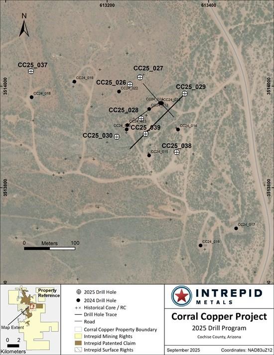
Figure 1: Drill plan map from the Ringo Zone at Corral Copper
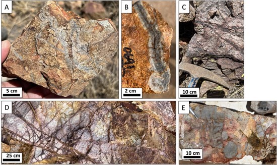
Figure 2. Examples of porphyry alteration style and veins at Corral Copper including A) quartz vein stockwork, B) porphyry style B-vein containing banded grey domains, C) quartz-magnetite veins in Bolsa quartzite, D) porphyry style D-Vein stockwork in quartz-sericite altered intrusive and E) silicified-clast heterolithic hydrothermal cement breccia.
Table 1: Drill Intercepts for the Ringo Zone1
| CC25_038 & CC25_039 COMPOSITE INTERCEPTS | |||||||||
| DRILL HOLE DETAILS | ANALYZED GRADE | DILUTED METAL EQUIVALENT1 |
|||||||
| DRILL HOLE | FROM | TO | LENGTH | COPPER | GOLD | SILVER | ZINC | CUEQ | AUEQ |
| ID | (m) | (m) | (m) | (%) | (ppm) | (ppm) | (%) | (%) | (ppm) |
| CC25_0384 | 22.10 | 28.50 | 6.40 | 0.03 | 0.10 | 1.15 | 0.01 | 0.10 | 0.13 |
| 40.00 | 66.50 | 26.50 | 0.15 | 0.04 | 0.48 | 0.00 | 0.16 | 0.20 | |
| 69.50 | 154.55 | 85.05 | 0.48 | 0.28 | 4.33 | 0.33 | 0.70 | 0.90 | |
| Incl. | 72.50 | 129.00 | 56.50 | 0.63 | 0.36 | 4.98 | 0.47 | 0.92 | 1.18 |
| And | 106.00 | 118.85 | 12.85 | 2.33 | 1.02 | 11.89 | 1.81 | 3.16 | 4.08 |
| Incl. | 139.20 | 139.90 | 0.70 | 4.42 | 0.64 | 68.30 | 1.10 | 4.39 | 6.36 |
| CC25_0384 | 155.45 | 211.00 | 55.55 | 0.23 | 0.15 | 5.44 | 0.17 | 0.37 | 0.48 |
| Incl. | 157.85 | 176.45 | 18.60 | 0.55 | 0.27 | 3.77 | 0.07 | 0.68 | 0.88 |
| And | 171.50 | 176.45 | 4.95 | 1.32 | 0.36 | 6.64 | 0.11 | 1.42 | 1.83 |
| 226.60 | 228.00 | 1.40 | 0.04 | 0.06 | 2.30 | 0.04 | 0.10 | 0.13 | |
| 233.45 | 237.00 | 3.55 | 0.18 | 0.09 | 3.47 | 0.14 | 0.27 | 0.35 | |
| 250.00 | 251.50 | 1.50 | 0.01 | 0.03 | 1.50 | 0.30 | 0.12 | 0.15 | |
| 254.50 | 257.80 | 3.30 | 0.03 | 0.09 | 3.74 | 0.05 | 0.12 | 0.16 | |
| CC25_0395 | 14.50 | 16.00 | 1.50 | 0.02 | 0.08 | 2.40 | 0.00 | 0.08 | 0.11 |
| 22.00 | 23.10 | 1.10 | 0.04 | 0.08 | 2.70 | 0.00 | 0.10 | 0.14 | |
| 26.65 | 70.60 | 43.95 | 0.14 | 0.04 | 1.21 | 0.01 | 0.15 | 0.21 | |
| Incl. | 32.40 | 50.60 | 18.20 | 0.23 | 0.06 | 1.56 | 0.02 | 0.24 | 0.33 |
| 73.00 | 220.50 | 147.50 | 0.23 | 0.15 | 3.01 | 0.06 | 0.32 | 0.43 | |
| Incl. | 78.70 | 100.40 | 21.70 | 0.41 | 0.15 | 2.16 | 0.01 | 0.45 | 0.61 |
| Incl. | 124.05 | 203.30 | 79.25 | 0.26 | 0.21 | 4.59 | 0.10 | 0.40 | 0.55 |
| And | 124.05 | 161.50 | 37.45 | 0.16 | 0.21 | 3.48 | 0.11 | 0.31 | 0.42 |
| And | 170.70 | 203.30 | 32.60 | 0.45 | 0.26 | 6.45 | 0.04 | 0.59 | 0.81 |
| And | 179.50 | 200.00 | 20.50 | 0.61 | 0.32 | 7.42 | 0.03 | 0.77 | 1.05 |
| 226.55 | 241.00 | 14.45 | 0.12 | 0.05 | 3.22 | 0.07 | 0.17 | 0.24 | |
Table 2: Drill Hole Location Information for Holes CC25-026 through CC25_045
| DRILL | START | END | EASTING | NORTHING | ELEVATION | AZIMUTH | INCLINATION | DEPTH |
| HOLE | DATE | DATE | (m) | (m) | (m) | (°) | (°) | (m) |
| CC25_026 | 2025-04-28 | 2025-05-03 | 613245 | 3514003 | 1424 | 0 | -90 | 234.4 |
| CC25_027 | 2025-05-04 | 2025-05-08 | 613265 | 3514017 | 1423 | 0 | -90 | 224.65 |
| CC25_028 | 2025-05-09 | 2025-05-16 | 613267 | 3513936 | 1420 | 0 | -90 | 240.8 |
| CC25_029 | 2025-05-17 | 2025-05-23 | 613353 | 3513985 | 1415 | 225 | -60 | 305.1 |
| CC25_030 | 2025-05-24 | 2025-05-30 | 613219 | 3513900 | 1423 | 0 | -90 | 270.7 |
| CC25_031 | 2025-05-31 | 2025-06-06 | 611891 | 3515918 | 1501 | 235 | -40 | 320.65 |
| CC25_032 | 2025-06-07 | 2025-06-12 | 612028 | 3515934 | 1472 | 0 | -90 | 313.05 |
| CC25_033 | 2025-06-12 | 2025-06-17 | 612135 | 3515757 | 1485 | 235 | -80 | 230.1 |
| CC25_034 | 2025-06-18 | 2025-06-22 | 612169 | 3514840 | 1495 | 250 | -45 | 204.2 |
| CC25_035 | 2025-06-22 | 2025-06-29 | 612258 | 3514776 | 1494 | 245 | -50 | 249.95 |
| CC25_036 | 2025-06-30 | 2025-07-06 | 612177 | 3514898 | 1497 | 250 | -50 | 219.6 |
| CC25_037 | 2025-07-07 | 2025-07-18 | 613050 | 3514029 | 1435 | 0 | -90 | 334.65 |
| CC25_038 | 2025-07-19 | 2025-07-29 | 613337 | 3513870 | 1422 | 0 | -90 | 282.55 |
| CC25_039 | 2025-07-30 | 2025-08-09 | 613276 | 3513906 | 1420 | 0 | -90 | 255.75 |
| CC25_040 | 2025-08-10 | 2025-08-22 | 613341 | 3513664 | 1438 | 0 | -90 | 331.30 |
| CC25_041 | 2025-08-23 | 2025-08-27 | 613099 | 3513981 | 1428 | 0 | -90 | 310.00 |
| CC25_042 | 2025-08-28 | 2025-09-02 | 613188 | 3513970 | 1425 | 0 | -90 | 274.90 |
| CC25_043 | 2025-09-03 | 2025-09-10 | 613305 | 3514040 | 1420 | 0 | -90 | 212.15 |
| CC25_044 | 2025-09-11 | 2025-09-15 | 613156 | 3513936 | 1425 | 0 | -90 | 290.15 |
| CC25_045* | 2025-09-15 | 614067 | 3513972 | 1411 | 215 | -70 |
*Hole in progress at time of news release
Quality Assurance and Quality Control
Drill core was first reviewed by a geologist, who identified and marked intervals for sampling. The marked sample intervals were then cut in half with a diamond saw; half of the core was left in the core box and the other half was removed, placed in plastic bags, sealed and labeled. Intervals and unique sample numbers are recorded on the drill logs and the samples are sequenced with standards and blanks inserted according to a predefined QA/QC procedure. The samples are maintained under security on site until they are shipped to the analytical lab.
All core samples were sent to ALS Geochemistry, a division of ALS Global, in Tucson, Arizona, for sample preparation, with pulps sent to the ALS Geochemistry laboratory in Reno, Nevada for analysis. ALS meets all requirements of International Standards ISO/IEC 17025:2017 and ISO 9001:2015 for analytical procedures and is independent of the Company. HQ size core was split and sampled over approximately two metre intervals. Samples were analyzed using: ALS’s Fire Assay Fusion method (Au-AA23) with an AA finish for gold and by gravimetric finish (Au-GRA21) for samples assaying greater than 10 ppm (gpt) gold; by a 36-element four acid digest ICP-AES analysis (ME-ICP61) with additional analysis for High Grade Cu (Cu-OG62), High Grade Zn (Zn-OG62) and High Grade Pb (Pb-OG62); and for silver assays above 100 ppm (g/t) by Fire Assay Fusion method with gravimetric finish (Ag-GRA21). ME-ICP61 results were reported in parts per million (ppm), High Grade (OG62) results were reported in percent (%). In addition to ALS quality assurance- quality control (QA/QC) protocols, Intrepid implements an internal QA/QC program that includes the insertion of sample blanks, duplicates, and standards, with QA QC control samples comprising approximately 10% of the sample stream.
About Corral Copper
The Corral Copper Property, located near historical mining areas, is an advanced exploration and development opportunity in Cochise County, Arizona. Corral is located 15 miles east of the famous mining town of Tombstone and 22 miles north of the historic Bisbee mining camp which has produced more than 8 billion pounds of copper4. Production from the Bisbee mining camp, or within the district as disclosed in the next paragraph, is not necessarily indicative of the mineral potential at Corral.
The district has a mining history dating back to the late 1800s, with several small mines extracting copper from the area in the early 1900s, producing several thousand tons. Between 1950 and 2008, various companies explored parts of the district, but the effort was uncoordinated, non-synergistic and focused on discrete land positions and commodities due to the fragmented ownership. There is over 50,000m of historical drilling at Corral mainly centered on the Ringo, Earp and Holliday Zones and although this core has been destroyed, Intrepid has a historical digital drill hole archive database which the Company uses for the purposes of exploration targeting and drill hole planning. Intrepid, through ongoing exploration drilling and surface geological mapping, sampling and prospecting is increasing confidence in the validity of this data.
Intrepid is confident that by combining modern exploration techniques with historical data and with a clear focus on responsible development, the Corral Copper Property can quickly become an advanced exploration stage project and move towards development studies.
About Intrepid Metals Corp.
Intrepid Metals Corp. is a Canadian company focused on exploring for high-grade essential metals such as copper, silver, and zinc mineral projects in proximity to established mining jurisdictions in southeastern Arizona, USA. The Company has acquired or has agreements to acquire several drill ready projects, including the Corral Copper Project (a district scale advanced exploration and development opportunity with significant shallow historical drill results), the Tombstone South Project (within the historical Tombstone mining district with geological similarities to the Taylor Deposit, which was purchased for $1.3B in 20185, though mineralization at the Taylor Deposit is not necessarily indicative of the mineral potential at the Tombstone South Project) both of which are located in Cochise County, Arizona and the Mesa Well Project (located in the Laramide Copper Porphyry Belt in Arizona). Intrepid has assembled an exceptional team with considerable experience with exploration, developing, and permitting new projects within North America.
Hudbay Minerals Inc. (TSX:HBM) (NYSE: HBM) today released its ann... READ MORE
Strategic acquisition of an established operating gold mine, loca... READ MORE
Cerro de Pasco Resources Inc. (TSX-V: CDPR) (OTCQB: GPPRF) (FRA: ... READ MORE
The Garneau Titanium Project Features Ilmenite-Rich Boulder with ... READ MORE
ValOre Metals Corp. (TSX‐V: VO) (OTCQB: KVLQF) (Frankfurt: KEQ0... READ MORE


