







The Prospector News

High-Grade Sediment Hosted Mineralization Extended at Pampa Medina – 300m Western Step-out SMRD-16 Intersects 10m of 4.2% Cu within 70m of 1.0% Cu

You have opened a direct link to the current edition PDF

Open PDF Close
Uncategorized

Share this news article

High-Grade Sediment Hosted Mineralization Extended at Pampa Medina – 300m Western Step-out SMRD-16 Intersects 10m of 4.2% Cu within 70m of 1.0% Cu


Marimaca Copper Corp. (TSX:MARI) (ASX:MC2) is pleased to announce further drilling at the Pampa Medina deposit, extending the high-grade sediment-hosted manto-system 300m to the west from previous drilling. Pampa Medina is located at low altitude approximately 28km east of the Company’s Marimaca Oxide Deposit in a flat “pampa” valley within the Atacama Desert (Figure 1). The Company is executing a 10,000m extensional drilling program with three rigs currently on site.


Highlights

  • Hole SMRD-16 extends the high-grade manto-system a further 300m to the west, with varying depths of the oxide to sulphide transition (Figure 1 and 4)
    • Further validation of the Pampa Medina exploration model: a unique stratiform, sediment hosted, copper system with extensive high-grade sequences
  • Interbedded sandstone, shale and conglomerate units continue to deliver the highest-grade zones (>1% Cu) across broad thicknesses
  • The favourable mineralized stratigraphic sequence is now defined by drilling across a 1.2km x 1.2km area at the Pampa Medina deposit and remains open – extensional drilling will focus on the north and the west
  • Highlights from SMRD-16 (true widths estimated to be 95% of reported intersection):
    • 70m of 1.0% from 434m including:
      • 10m of 4.2% Cu from 438m downhole within 30m of 2.1% Cu from 434m (Figure 3)
      • Oxide and secondary sulphide
    • 116m of 0.61% Cu from 516m including:
      • 8m of 1.8% Cu from 528m (sulphide)
      • 10m of 1.2% Cu from 568m (sulphide)
      • 20m of 1.1% Cu from 612m (sulphide)
    • 50m of 0.53% Cu from 744m including:
      • 10m of 1.1% Cu from 782m (sulphide)
  • Hole SMRD-15 demonstrates uplifting of the eastern extension, with a broad zone of near-surface oxide mineralization intersected at 122m down hole in hosted by remnants of sediments just above the contact with basement rocks
    • SMRD-15 intersected 42m of 0.51% Cu from 158m (oxides)
  • SMRD-16 extends the high-grade mineralized manto 300m west along section from previously reported holes (see Figure 4):
  • Hole SMRD-13 (300m west of SMRD-15)
    • 6m of 12.0% Cu from 594m downhole within 26m of 4.1% Cu from 580m and a broader 100m of 1.3% Cu from 580m
  • Hole SMD-02 (600m east of SMRD-16 on section) (previously reported)
    • 40m of 2.1% Cu from 282m downhole within 132m of 1.0% Cu from 278m
  • Hole SMRD-12 (300m east of SMRD-16 on section) (previously reported)
    • 56m of 1.4% Cu from 566m downhole
  • Similar to the MOD, Pampa Medina’s location is expected to drive significant infrastructure and permitting benefits:
    • Proximity to other mines and associated infrastructure (Figure 1): 28km from the MOD, 64km from Sierra Gorda (South32/KGHM), 40km from Mantos Blancos (Capstone Copper), 77km from Spence (BHP), 54km from Antucoya (Antofagasta Minerals)
    • Low altitude, flat “pampa” type surface provides sufficient space for future facilities and infrastructure
    • Proximity to existing powerlines, water pipelines, major ports and regional populations
    • No private land ownership, limited human impact (no nearby local or indigenous population), extremely arid location indicates low permitting risks (comparable or superior to the MOD) associated with potential development


Sergio Rivera, VP Exploration of Marimaca Copper, commented:


“SMRD-16 is a further 300m step out to the west of the previously announced SMRD-12 and has intersected a similar broad zone of high-grade copper mineralization, including 70m at 1.0% and a number of discrete very high-grade zones.


“The area of interest currently confirmed by drill intersections extends over 1.2km east-west by 1.2km north-south, with an average true thickness of between 50m to 100m. We currently have no observable reasons to indicate that mineralization would not be continuous while the sedimentary unit exists and, as a result, we see enormous potential to both the north and west of the current drilling.


“To the east, the block was uplifted significantly, which caused a thinning of the mineralization. Despite this, we intersected a broad zone of oxide copper mineralization at above economic cut-off grades for Pampa Medina and we, therefore, continue to see strong potential for oxide resource growth in all directions.


“Our strategy remains to step out significantly to try to define the limits of what is a very large system, but we will now also turn our attention to planning an infill campaign in the broader Pampa Medina project area with the objective of delineating updated resources for the project.”


Hayden Locke, President and CEO of Marimaca Copper, commented:


“The depth of these new intersections continue to indicate that it will be an underground opportunity, once the Pampa Medina oxide open pit has been considered. Our early analysis indicates an economic cut-off grade requirement of between 0.5% and 0.8%, depending on copper price. With that in mind, we are targeting mineralized intersections with true widths exceeding 20m at an average copper grade of 1.0% or more. The last four drill holes have delivered widths and grades that materially surpass this requirement and, as a result, we see enormous potential for a large scale, highly economic, underground copper mining opportunity.


“Sergio Rivera and our exploration team continue to deliver outstanding value with the extension of the thick, high grade manto mineralization to the west. The continued exploration success at Pampa Medina reinforces our goal at Marimaca: to become a significant copper producer with the unique, low-cost, advanced-stage asset in the MOD, and transformational district scale upside anchored by Pampa Medina and Madrugador.


“With the upcoming release of the MOD DFS, our strategy remains multi-pronged: 1) deliver a near-term, low-cost 50ktpa copper cathode mine in a Tier-1 jurisdiction; 2) advance the Pampa Medina and Madrugador Oxide projects to grow our cathode production and extend mine life; and 3) continue to define the district-scale exploration potential of our large land package.”


Overview of Pampa Medina


Pampa Medina is a stratiform or manto-style copper deposit dominantly hosted in Jurassic-Triassic sedimentary units (sandstones, conglomerates, tuffs and black shales) overlain by andesitic volcanics and underlain by an Upper Paleozoic complex of metamorphosed sediments, volcanics and intrusions. It´s intruded by a dyke swarm and affected by post mineral normal faulting (Figure 4). Copper was originally identified in near-surface oxide mineralization dominated by atacamite, chrysocolla and both secondary and primary chalcocite, and has now been identified in high-grade zones of chalcopyrite and bornite which extend laterally down-dip beyond the oxide-primary transition.


Following Marimaca’s consolidation of the project area and surrounding land packages in 2024, the Company reinterpreted all available geological information (for the first time as one) and developed an updated geological model for Pampa Medina, which identified the lower sedimentary units of interbedded sandstones, shales and conglomerates as the productive horizons for future drill targeting. Oxide copper mineralization was logged in historical drilling in near-surface, uplifted blocks, with the model of continuity in the intact lithological sequence in deeper blocks for primary mineralization to be tested by Marimaca’s 2025 drilling campaign.


SMRD-16 materially extends the high-grade manto to the west, increasing the defined mineralized stratigraphy across a 1.2km by 1.2km area (Figures 2 and 4). Weakly mineralized sandstones were intercepted from 116m, with the main high-grade mixed-sulphide, sediment hosted mineralization starting at 438m downhole. Hole SMRD-15 was planned to confirm the uplifted basement in the eastern direction of the Pampa Medina main target. Oxide mineralization was intercepted at 122m, extending to 204m depth (Figure 3). Exploration focus will remain on the western and northern regions of the Pampa Medina main target, which both remain open.
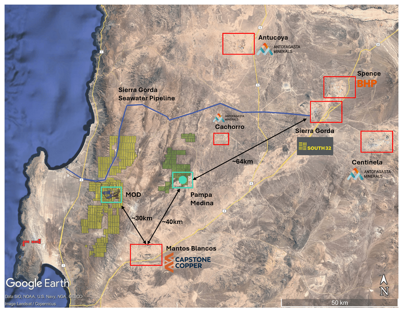
 

Figure 1: Regional Map – Marimaca, Pampa Medina and Regional Infrastructure
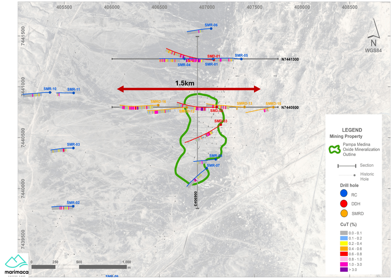


 Figure 2 – Pampa Medina Deposit and Step-out Drilling Locations
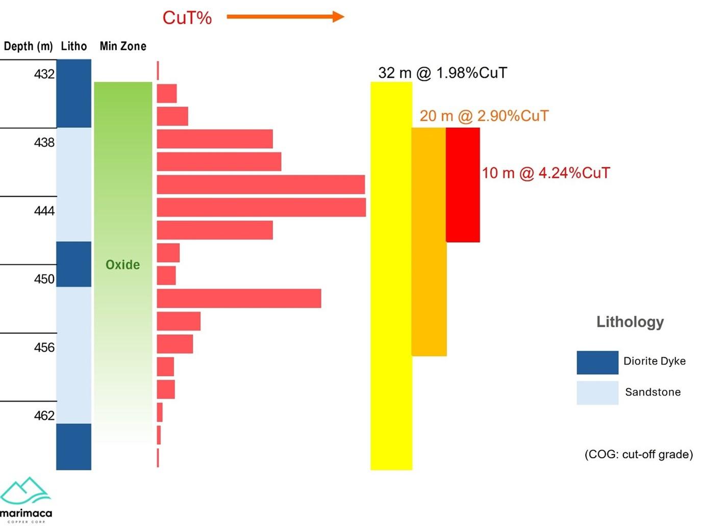


Figure 3 – Pampa Medina Lithology – SMRD-16 Downhole Sequence
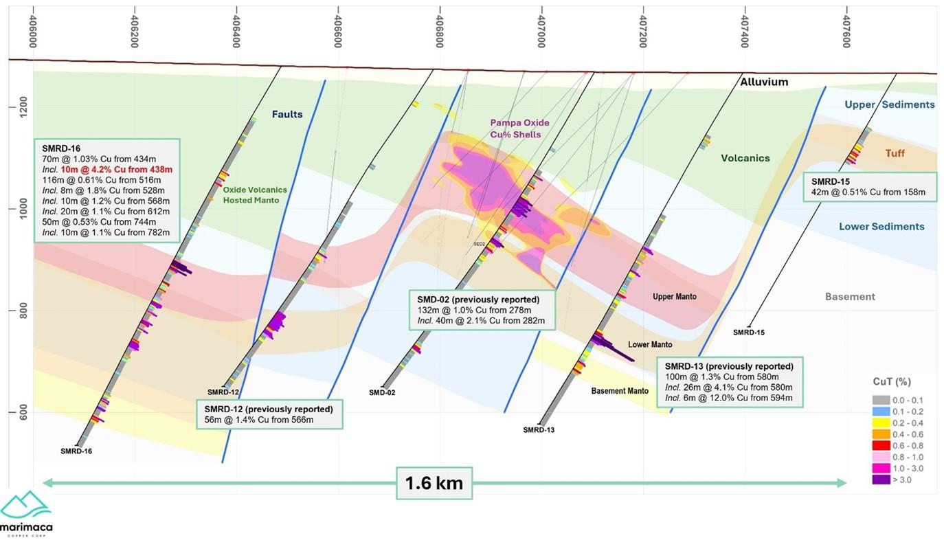
 

 Figure 4 – Cross Section Looking North – Pampa Medina SMRD-15 to SMRD-16


Hole Total Depth (m)   From (m) To (m) Intersection (m) % CuT
SMRD-15 580   122 200 78 0.31
Including 158 200 42 0.51
Including 188 198 10 0.83
SMRD-16 850   236 266 30 0.43
And 434 794 360 0.49
Including 434 504 70 1.03
Including 434 464 30 2.10
Including 438 448 10 4.24
Including 516 632 116 0.61
Including 516 536 20 0.91
Including 528 536 8 1.80
Including 568 590 22 0.90
Including 568 578 10 1.24
Including 612 632 20 1.14
Including 744 794 50 0.53
Including 782 792 10 1.10

Table 1: Table of Intersections


Hole Easting Northing Elevation Azimuth Inclination Depth
SMRD-15 7440799.14 407698.23 1267.17 270 -60 580
SMRD-16 7440819.3 406488.16 1282.01 270 -60 850

Table 2: Drill Collars


Sampling and Assay Protocols


True widths are estimated as 95% of reported intervals, based on down-hole bedding and structural measurements. DDH holes were sampled on a 2m continuous basis, halved by a conventional core splitter on site with one half sent to the Andes Analytical Assay preparation laboratory in Copiapó and the pulps then sent to the same company laboratory in Santiago for assaying. Samples were prepared using the following standard protocol: drying; crushing all sample to -1/4” and passing through a secondary crusher to better than 80% passing -10#; homogenizing; splitting; pulverizing a 400-600g subsample to 95% passing -150#; and a 125g split of this sent for assaying. All samples were assayed for %CuT (total copper); %CuS (acid soluble copper). A full QA/QC program, involving insertion of appropriate blanks, standards and duplicates was employed with acceptable results. Pulps and sample rejects are stored by Marimaca Copper for future reference.


Qualified Person / Competent Person


The technical information in this news release, including the information that relates to geology, drilling and mineralization was prepared under the supervision of, or has been reviewed by Sergio Rivera, Vice President of Exploration, Marimaca Copper Corp, a geologist with more than 40 years of experience and a member of the Colegio de Geólogos de Chile and of the Institute of Mining Engineers of Chile, and who is the Qualified Person for the purposes of NI 43-101 responsible for the design and execution of the drilling program.


The information in this announcement which relates to exploration results for the Pampa Medina Project is based on, and fairly reflects, information and supporting documentation prepared by Sergio Rivera, VP Exploration of Marimaca, a Competent Person who is a member of the Comision Minera (Chilean Mining Commission), Colegio de Geólogos de Chile and of the Institute of Mining Engineers of Chile. Mr. Rivera has sufficient experience that is relevant to the style of mineralisation and types of deposit under consideration and to the activity being undertaken to qualify as a Competent Person as defined in the 2012 Edition of the Joint Ore Reserves Committee Australasian Code for Reporting of Exploration Results, Mineral Resources and Ore Reserves. Mr. Rivera consents to the inclusion in this announcement of the matters based on his information in the form and context in which it appears.

Posted August 15, 2025

Share this news article

MORE or "UNCATEGORIZED"


Critical Metals Corp Achieves Breakthrough Tanbreez Heavy Rare Earth Results: >99% Dissolution of Eudialyte Concentrate Into 19 Ultra-High-Purity Rare Earth Products; Refinery Study Projects US$1.8–2.2b in Annual Refinery Revenue

Critical Metals Corp. (Nasdaq: CRML) a leading critical minerals ... READ MORE

September 16, 2026

Metalsource Mining Extends High Grade Mineralization at Depth as Silver Hill Exploration Enters Major Expansion Phase

Holes SH26-22 and SH26-23 return up to 930 g/t AgEq within broade... READ MORE

September 16, 2026

Pasinex Completes Sale of High-Grade Zinc Sulphide Material and Provides Pinargozu Operations Update

Pasinex Resources Limited (CSE: PSE) (FSE: PNX) a growing zinc-fo... READ MORE

September 16, 2026

Aya Gold & Silver Reports High-Grade Silver Exploration Results Near Pit and at Depth at Zgounder

Aya Gold & Silver Inc. (TSX: AYA; NASDAQ: AYA) is pleased to... READ MORE

September 16, 2026

New Break Resources Ltd. (CSE: NBRK) (OTCQB: NBRKF) (FSE: O91) has received results from the last four holes of a ten-hole, 1,996 metre summer drilling program in the Zavitz gold zone at the Company's 100% owned Moray gold project. In total, New Break has completed 5,372 metres of drilling in 32 drillholes in 2026. Moray is located 49 km southeast of Timmins, Ontario and 32 km northwest of the Young-Davidson gold mine operated by Alamos Gold Inc. Select results from the final four of ten holes drilled in the summer drilling program are presented below in Table 1, while drillhole collar locations are detailed in Table 2 in Appendix A. Table 1 – Moray Summer 2026 Final Drill Results Hole ID Length (m) From (m) To (m) Width (1) (m) Au Grade (2) (g/t) NBR-26-29 322.0 77.3 78.8 1.5 0.42 and 138.0 139.1 1.1 0.38 and 162.5 173.3 10.8 (3) 1.61 and 227.4 229.0 1.6 1.21 and 231.5 232.1 0.6 1.72 NBR-26-30 250.0 37.0 38.0 1.0 0.30 and 102.8 103.5 0.7 0.60 and 121.5 122.5 1.0 0.36 and 124.5 125.5 1.0 0.33 and 128.5 129.0 0.5 0.90 and 131.0 132.0 1.0 0.36 and 169.8 174.0 4.2 2.65 and 178.0 179.5 1.5 0.77 and 183.5 186.6 3.1 1.22 and 190.0 190.5 0.5 1.06 and 191.5 192.5 1.0 1.48 and 196.0 200.5 4.5 2.53 and 203.5 204.0 0.5 2.15 and 206.5 212.0 5.5 1.57 NBR-26-31 274.0 169.0 170.5 1.5 0.37 and 184.5 186.0 1.5 0.51 and 197.0 200.0 3.0 0.94 and 201.5 202.0 0.5 0.50 and 203.5 210.0 6.5 (3) 3.12 NBR-26-32 352.0 73.5 74.0 0.5 0.44 and 174.0 174.6 0.6 0.52 and 194.0 195.0 1.0 0.66 and 199.8 203.3 3.5 2.29 and 227.3 228.0 0.7 0.97 (1) Intervals are drill intersections and do not necessarily represent true widths. (2) All intervals are presented using a cut-off grade of 0.3 g/t Au and internal dilution of no more than 1.0 metres at grades less than 0.3 g/t Au and assays are not capped (see QA/QC Procedures). (3) Drill core photos shown in Appendix B. Figure 1 – Newly Reported Drillholes NBR-26-29, 30 Figure 2 – Newly Reported Drillholes NBR-26-30, 31, 32 Note: The bottom of NBR-26-30 deviated southeast and is represented in both sections. Figure 1: Section B-B1 incorporates drillholes NBR-26-06, 07, 08, 25, 26, 27, 28, 29 and part of 30. Gold mineralization extends southeast into the syenite as exhibited in NBR-26-29. NBR-26-30 is identified in both sections A-A1 and B-B1 as the drillhole was collared along section A-A1 but deviated southeast, intersecting gold mineralization in the mafic volcanics in section B-B1. Figure 2: A-A1 incorporates drillholes NBR-26-03, 04, 05, 23, 24, 30, 31 and 32. NBR-26-31 exhibits gold mineralization both within the syenite (at the contact) and within a "flow breccia" within the hematite altered mafic volcanic at the contact. NBR-26-32 is typified by blocky faulted ground with lamprophyre dykes and gold mineralization in the hematite altered mafic volcanics in a brecciated quartz vein with angular syenitic fragments. William Love, Chief Executive Officer of New Break commented, "Ongoing drilling this summer in the Zavitz gold zone continues to deliver significant gold values, with gold mineralization intercepted in every drillhole. As depicted in Figures 1 and 2, gold mineralization has been encountered predominantly within the mafic volcanics. Importantly, drillholes NR-26-29 and NR-26-32, the deepest drilled to date, demonstrate that gold mineralization extends into the syenite to the southeast at the contact with the mafic volcanics." He further noted, "The intrusive-mafic volcanic contact in the Zavitz gold zone has a distinctive magnetic high. This could be reflective of the higher proportion of iron in these mafic volcanics, which is associated with the higher gold values. This same magnetic and IP signature has been identified elsewhere in areas also believed to be along the intrusive-mafic volcanic contact. Drilling these never before tested targets with the goal of identifying gold mineralization similar to that encountered in the Zavitz zone represents the potential for significantly expanding the Moray gold discovery. There is also the belief that the Zavitz zone could represent the first of a series of stacked mineralized gold zones, which would point to the potential for a much larger gold system at depth. We plan to test this through deeper drilling directly into the Zavitz zone." About the Moray Gold Project The Moray property is located in the heart of the Ontario Abitibi greenstone belt, 49 km southeast of Timmins surrounded by a number of significant gold producing companies and existing mills (see Figure 3). The Young-Davidson gold mine operated by Alamos Gold Inc., with its 8,000 tonne per day mill is the closest and within a short trucking distance of approximately 45 km by road from Moray. The understanding of gold mineralization at Moray continues to evolve with each round of drilling. The occurrence of gold mineralization extending into the syenite to the southeast of the Zavitz zone and in the deepest drillholes is noteworthy given the presence of syenite-hosted mineralization at Young-Davidison. More recent examination of the drill core also suggests that the gold mineralization discovered to date may resemble an intrusion related style of deposit like Agnico Eagle's Upper Beaver gold deposit east of Kirkland Lake, as opposed to a structurally hosted gold system. Both Young-Davidson and Upper Beaver host multi-million ounce gold deposits. Figure 3 – Moray Location Map: Surrounding Gold Producers and Upper Beaver Gold Project Technical Content and Qualified Person The scientific and technical information contained in this news release has been reviewed and approved by Peter C. Hubacheck, P. Geo, consulting geologist to New Break, and an independent Qualified Person as defined by National Instrument 43-101. Mr. Hubacheck certifies that this news release fairly and accurately reflects the technical information and data presented. New Break conducts its exploration activities in accordance with CIM Best Practices Guidelines. QA/QC Procedures QA/QC procedures were executed to ensure all work is conducted in accordance with best practices. All drill core was sawn in half with one half of the core prepared for shipment and the other half retained for future verification. All core is under watch from the drill site to the core processing facility. Drill core is BQTK size and sample intervals range from 0.5 metres to 1.0 metres in length. Commercially prepared certified reference material ("CRM") standards and blanks were inserted with each shipment at a rate of 1 QAQC sample in every 12 core samples. Samples from New Break's 2026 Moray drilling program were analyzed at Activation Laboratories in Timmins, Ontario, which is ISO 17025 certified, by 30-gram fire assay with atomic absorption finish. Any sample assaying greater than 10.0 g/t Au was re-assayed with fire assay gravimetric analysis. Grade composite intervals over core lengths are calculated using a weighted average grade with a cut-off grade of 0.3 g/t Au. Up to 1.0 m of internal dilution (consecutive interval below cut-off grade) are included within specific geologic domains and alteration assemblages, except as otherwise noted. The composites are constrained geologically by metasomatic alteration processes sourcing from the Fiset syenite intrusion and contact mafic volcanic rocks. Elevated gold values are coincident with hematite, silica, sericite and pyrite mineralization within structurally prepared brecciated corridors flanking the intrusion. Intervals are not true widths and no top cutting has been applied to the higher gold values. About New Break Resources Ltd. New Break is a Canadian mineral exploration company focused on its Moray gold project located 49 km southeast of Timmins, Ontario, in a well-established mining camp within proximity to existing infrastructure, and 32 km northwest of the Young-Davidson gold mine, operated by Alamos Gold Inc. Shareholders are also leveraged to exploration success in Nunavut, Canada, through New Break's 20% carried interest in the Sundog gold project and ownership of 6.0 million shares of Guardian Exploration Inc. (TSXV: GX). The Company is supported by a highly experienced team of mining professionals. Appendix A – Drillhole Data and Locations Table 2 – Moray Summer 2026 Drillhole Collar Locations Hole ID Length (m) UTM Easting UTM Northing UTM Elevation Azimuth (degrees) Dip (degrees) NBR-26-29 322.0 492703 5320285 363 220 -70 NBR-26-30 250.0 492708 5320329 363 220 -47 NBR-26-31 274.0 492708 5320329 363 220 -60 NBR-26-32 352.0 492708 5320329 363 220 -70 Total 1,198.0 Coordinates are reported in UTM Zone 17 North, with units in metres. Figure 4 – Zavitz Gold Zone – Surface Traces of 2025 and 2026 Drillholes. All of the drilling at Moray has been completed by Enviro North Exploration Inc. out of Sturgeon Falls, Ontario. Drilling in the Zavitz gold zone is shown in figure 4, with the 1,996 metres in 10 holes drilled this summer depicted in red, the 2,807 metres in 20 holes drilled from January to April 2026 shown in blue and the 1,817 metres in 8 holes drilled in 2025 shown in black. In total, 6,620 metres in 38 drillholes have been completed in the Zavitz gold zone, while New Break has completed a total of 5,372 metres in 32 drillholes of our planned 2026, 10,000 metre drilling program. Appendix B – Drill Core Photos From NBR-26-29 and NBR-26-31

New Break Resources Ltd. (CSE: NBRK) (OTCQB: NBRKF) (FSE: O91) ha... READ MORE

September 16, 2026

Copyright 2026 The Prospector News
