


6,490 g/t AgEq over 0.8m within 16.3m of 605 g/t AgEq
GoGold Resources Inc. (TSX: GGD) (OTCQX: GLGDF) is pleased to announce additional drilling results from Los Ricos South, within the Eagle and Main Deposits. Hole LRGAG-22-113 intercepted 16.3m of 605 g/t silver equivalent, containing 6,490 g/t AgEq over 0.8m, and. The hole also intercepted an additional 12.3m of 462 g/t AgEq. See Table 1 for breakdown of silver and gold values. A cross section of hole LRGAG-22-113 is included as Figure 1 below.
“Impressive drill results continue to come in for the Eagle,” said Brad Langille, President and CEO. “We expect these holes, along with our previously released drilling results, will provide a very positive impact when we update our Mineral Resource Estimate and Preliminary Economic Assessment at Los Ricos South later this year. ”
Table 1: Drill Hole Intersections
| Hole ID | Area / Vein | From | To | Length1 | Au | Ag | AuEq2 | AgEq2 |
| (m) | (m) | (m) | (g/t) | (g/t) | (g/t) | (g/t) | ||
| LRGAG-22-101 | Eagle | 196.1 | 198.0 | 1.9 | 1.00 | 11.3 | 1.15 | 86.6 |
| LRGAG-22-102 | Eagle | 203.6 | 205.2 | 1.6 | 2.39 | 67.9 | 3.29 | 247.0 |
| and | 218.4 | 219.4 | 1.0 | 2.36 | 3.4 | 2.41 | 180.4 | |
| LRGAG-22-104 | Eagle | 182.0 | 184.0 | 2.0 | 4.71 | 12.6 | 4.87 | 365.5 |
| including | 182.0 | 183.0 | 1.0 | 9.04 | 18.0 | 9.28 | 696.0 | |
| LRGAG-22-105 | Eagle | 309.0 | 318.5 | 9.5 | 0.46 | 55.7 | 1.20 | 90.3 |
| including | 313.0 | 315.5 | 2.5 | 1.12 | 117.5 | 2.69 | 201.7 | |
| and | 335.4 | 349.4 | 14.0 | 0.91 | 35.7 | 1.38 | 103.8 | |
| LRGAG-22-106 | Eagle | 192.2 | 205.2 | 13.0 | 0.69 | 71.8 | 1.65 | 123.4 |
| including | 189.2 | 192.2 | 3.0 | 0.93 | 162.1 | 3.09 | 231.8 | |
| LRGAG-22-108 | Eagle | 130.5 | 138.0 | 7.5 | 0.44 | 78.7 | 1.49 | 111.8 |
| including | 132.0 | 133.0 | 1.0 | 1.35 | 179.0 | 3.74 | 280.3 | |
| LRGAG-22-110 | Eagle | 62.0 | 124.4 | 62.4 | 1.43 | 42.8 | 2.00 | 149.7 |
| including | 98.7 | 114.7 | 16.0 | 4.57 | 70.7 | 5.52 | 413.6 | |
| including | 102.6 | 103.9 | 1.4 | 17.05 | 189.0 | 19.57 | 1,467.7 | |
| LRGAG-22-112 | Eagle | 322.6 | 331.1 | 8.5 | 0.80 | 114.5 | 2.33 | 174.8 |
| including | 323.6 | 324.6 | 1.0 | 1.64 | 365.0 | 6.51 | 488.0 | |
| LRGAG-22-113 | Eagle | 132.8 | 149.0 | 16.3 | 3.29 | 357.7 | 8.06 | 604.8 |
| including | 133.8 | 135.6 | 1.8 | 20.05 | 2,000.0 | 46.72 | 3,503.7 | |
| including | 134.8 | 135.6 | 0.8 | 40.00 | 3,490.0 | 86.53 | 6,490.0 | |
| and | 160.5 | 190.0 | 29.5 | 2.32 | 57.8 | 3.09 | 231.7 | |
| including | 165.1 | 177.4 | 12.3 | 5.20 | 72.1 | 6.16 | 462.4 | |
| including | 169.0 | 170.0 | 1.0 | 21.10 | 170.0 | 23.37 | 1,752.5 | |
| LRGAG-22-115 | Eagle | 180.1 | 211.6 | 31.5 | 1.44 | 75.1 | 2.45 | 183.4 |
| including | 191.6 | 202.6 | 11.0 | 3.38 | 147.2 | 5.34 | 400.4 | |
| including | 200.6 | 201.6 | 1.0 | 12.85 | 64.0 | 13.70 | 1,027.8 | |
| LRGG-22-224 | Main area | 97.6 | 102.8 | 5.2 | 1.51 | 145.0 | 3.44 | 258.3 |
| including | 99.8 | 102.8 | 3.0 | 2.32 | 193.0 | 4.89 | 366.8 | |
| LRGG-22-225 | Main area | 254.4 | 260.2 | 5.8 | 0.50 | 91.0 | 1.71 | 128.2 |
| LRGG-22-226 | Main area | 136.5 | 137.9 | 1.4 | 1.10 | 153.1 | 3.14 | 235.8 |
| LRGG-22-227 | Main area | 124.0 | 153.0 | 29.0 | 1.28 | 105.2 | 2.68 | 200.9 |
| including | 130.6 | 137.0 | 6.3 | 4.84 | 352.0 | 9.54 | 715.2 | |
| including | 132.0 | 132.7 | 0.7 | 24.00 | 335.0 | 28.47 | 2,135.0 |
| 1. | Not true width |
| 2. | AgEq converted using a silver to gold ratio of 75:1 at recoveries of 100% |
| 3. | Holes LRGAG-22-103, 107, 109, 111, 114 did not intercept significant mineralization |
The Eagle Deposit adjoins the Main Deposit and represents a northern extension of the previously defined Mineral Resource Estimate in the Los Ricos South PEA. The Eagle concession covers 1,107 hectares, including the area between the Main Deposit and the Company’s Jamaica concession located 3km to the northwest, where the Company holds the rights to additional concessions. Drilling at the Eagle has returned the highest grade intercepts to date in the district. These wide high grade intercepts are consistent with geophysical targets on the new concession.
The LRGG holes contained in the results above are part of a new drilling program at the Main Deposit. The purpose of the program is to better define the very high grade portions of the current deposit that may be amenable to bulk underground mining. The Company is carrying out a trade-off study to better define what portion of the deposit could be mined in a lower strip ratio pit and what portion would best be mined in more selective bulk underground mining. These holes are in addition to those drilled in 2019 and 2020 which formed part of the initial resource upon which the Los Ricos South Preliminary Economic Assessment (“PEA”) was based upon when it was released on January 20, 2021.
A summary of Eagle zone drilling highlights is included as Table 2 below.
Table 2: Eagle Deposit Drill Intercept Highlights
| Hole ID | Area / Vein | From | To | Length1 | Au | Ag | AuEq2 | AgEq2 |
| (m) | (m) | (m) | (g/t) | (g/t) | (g/t) | (g/t) | ||
| LRGAG-22-118 | Eagle | 95.6 | 150.6 | 55.0 | 7.80 | 2,152.7 | 36.51 | 2,737.9 |
| including | 95.6 | 120.6 | 25.0 | 16.07 | 4,664.2 | 78.26 | 5,869.3 | |
| including | 104.6 | 119.6 | 15.0 | 26.74 | 7,755.8 | 130.15 | 9,761.3 | |
| including | 107.6 | 114.6 | 7.0 | 55.87 | 16,524.6 | 276.19 | 20,714.5 | |
| including | 107.6 | 110.6 | 3.0 | 121.97 | 36,953.0 | 614.67 | 46,100.5 | |
| including | 108.6 | 110.6 | 2.0 | 145.25 | 52,764.5 | 848.78 | 63,658.3 | |
| LRGAG-22-035 | Eagle | 69.0 | 179.6 | 110.6 | 1.64 | 264.6 | 5.17 | 387.5 |
| including | 129.0 | 140.5 | 11.5 | 11.31 | 2,198.3 | 40.62 | 3,046.7 | |
| including | 130.4 | 133.8 | 3.5 | 30.24 | 6,392.5 | 115.48 | 8,660.8 | |
| including | 130.4 | 131.9 | 1.5 | 63.24 | 12,729.3 | 232.96 | 17,472.0 | |
| including | 131.0 | 131.9 | 0.9 | 104.50 | 13,742.5 | 287.73 | 21,580.0 | |
| LRGAG-21-014 | Eagle | 144.3 | 216.9 | 72.6 | 5.13 | 76.0 | 6.14 | 460.6 |
| including | 198.8 | 210.7 | 11.9 | 28.58 | 115.9 | 30.13 | 2,259.8 | |
| including | 208.6 | 210.7 | 2.1 | 146.03 | 176.8 | 148.39 | 11,128.9 | |
| including | 208.6 | 209.3 | 0.7 | 266.00 | 319.0 | 270.25 | 20,269.0 | |
| LRGAG-22-031 | Eagle | 58.0 | 126.0 | 68.0 | 4.25 | 109.4 | 5.71 | 428.4 |
| including | 78.0 | 113.9 | 35.9 | 7.83 | 184.9 | 10.29 | 771.8 | |
| including | 80.0 | 95.0 | 15.0 | 15.61 | 273.3 | 19.26 | 1,444.4 | |
| including | 84.0 | 86.0 | 2.0 | 46.80 | 272.5 | 50.43 | 3,782.5 | |
| LRGAG-22-032 | Eagle | 48.1 | 113.8 | 65.8 | 1.36 | 107.7 | 2.79 | 209.6 |
| including | 85.8 | 113.8 | 28.1 | 2.96 | 216.6 | 5.85 | 439.0 | |
| including | 88.5 | 92.9 | 4.3 | 7.17 | 1,012.8 | 20.68 | 1,550.7 | |
| including | 88.5 | 89.1 | 0.6 | 25.00 | 3,020.0 | 65.27 | 4,895.0 | |
| LRGAG-22-041 | Eagle | 109.5 | 145.5 | 36.0 | 1.46 | 134.5 | 3.26 | 244.3 |
| including | 134.0 | 143.5 | 9.5 | 4.55 | 389.9 | 9.75 | 731.1 | |
| including | 134.0 | 134.8 | 0.8 | 6.01 | 577.0 | 13.70 | 1,027.7 | |
| also including | 137.0 | 143.5 | 6.6 | 5.62 | 453.6 | 11.67 | 875.3 | |
| including | 141.0 | 142.2 | 1.2 | 17.10 | 1,345.0 | 35.03 | 2,627.5 | |
| LRGAG-22-113 | Eagle | 132.8 | 149.0 | 16.3 | 3.29 | 357.7 | 8.06 | 604.8 |
| including | 133.8 | 135.6 | 1.8 | 20.05 | 2,000.0 | 46.72 | 3,503.7 | |
| including | 134.8 | 135.6 | 0.8 | 40.00 | 3,490.0 | 86.53 | 6,490.0 | |
| and | 160.5 | 190.0 | 29.5 | 2.32 | 57.8 | 3.09 | 231.7 | |
| including | 165.1 | 177.4 | 12.3 | 5.20 | 72.1 | 6.16 | 462.4 | |
| including | 169.0 | 170.0 | 1.0 | 21.10 | 170.0 | 23.37 | 1,752.5 | |
| LRGAG-21-018 | Eagle | 127.6 | 163.0 | 33.6 | 1.57 | 85.5 | 2.71 | 203.5 |
| including | 156.9 | 159.3 | 2.4 | 10.51 | 436.5 | 16.33 | 1,225.0 | |
| including | 156.9 | 157.6 | 0.8 | 15.00 | 1,155.0 | 30.40 | 2,280.0 | |
| and | 177.9 | 178.6 | 0.7 | 36.20 | 1,500.0 | 56.20 | 4,215.0 | |
| LRGAG-22-030 | Eagle | 42.9 | 79.5 | 36.7 | 1.77 | 156.2 | 3.85 | 289.0 |
| including | 51.9 | 61.0 | 9.1 | 6.00 | 553.3 | 13.38 | 1,003.2 | |
| including | 54.1 | 54.8 | 0.7 | 14.00 | 1,260.0 | 30.80 | 2,310.0 | |
| LRGAG-22-029 | Eagle | 74.0 | 94.6 | 20.6 | 1.52 | 217.5 | 4.42 | 331.3 |
| including | 75.5 | 77.5 | 2.0 | 8.00 | 1,865.5 | 32.87 | 2,465.5 | |
| including | 75.5 | 76.5 | 1.0 | 14.15 | 3,520.0 | 61.08 | 4,581.3 | |
| LRGAG-21-007 | Eagle | 148.5 | 191.0 | 42.5 | 1.64 | 137.5 | 3.47 | 260.6 |
| including | 188.6 | 190.2 | 1.6 | 6.83 | 1,269.5 | 23.76 | 1,781.8 |
Figure 4, which follows, provides a summary of the Los Ricos District, including both the Los Ricos North and Los Ricos South projects. The map includes an outline of the concession areas and a summary of the current Mineral Resource Estimates (“MRE”) on the projects, as well as stars locating each of the deposits included within the current MREs.
Table 3: Drill Hole Locations
| Hole ID | Easting | Northing | Elevation | Azimuth | Dip | Length |
| LRGAG-22-101 | 609964 | 2328357 | 1252 | 0 | -90 | 327 |
| LRGAG-22-102 | 609942 | 2328282 | 1272 | 50 | -67 | 273 |
| LRGAG-22-103 | 609823 | 2328439 | 1231 | 50 | -50 | 306 |
| LRGAG-22-104 | 609822 | 2328438 | 1231 | 50 | -65 | 351 |
| LRGAG-22-105 | 609942 | 2328282 | 1272 | 0 | -90 | 386 |
| LRGAG-22-106 | 610034 | 2328128 | 1317 | 50 | -55 | 274 |
| LRGAG-22-107 | 609820 | 2328437 | 1231 | 0 | -90 | 386 |
| LRGAG-22-108 | 610126 | 2328072 | 1310 | 50 | -45 | 184 |
| LRGAG-22-109 | 610126 | 2328072 | 1310 | 50 | -65 | 239 |
| LRGAG-22-110 | 610062 | 2328411 | 1283 | 50 | -60 | 170 |
| LRGAG-22-111 | 610126 | 2328072 | 1310 | 50 | -85 | 296 |
| LRGAG-22-112 | 609931 | 2328050 | 1326 | 50 | -55 | 377 |
| LRGAG-22-113 | 610060 | 2328410 | 1282 | 0 | -90 | 266 |
| LRGAG-22-114 | 609404 | 2328744 | 1247 | 50 | -45 | 310 |
| LRGAG-22-115 | 610035 | 2328259 | 1306 | 50 | -63 | 308 |
| LRGG-22-224 | 610410 | 2327788 | 1276 | 50 | -45 | 138 |
| LRGG-22-225 | 610220 | 2327768 | 1233 | 50 | -70 | 320 |
| LRGG-22-226 | 610306 | 2327803 | 1254 | 50 | -56 | 185 |
| LRGG-22-227 | 610440 | 2327718 | 1270 | 50 | -56 | 177 |
VRIFY Slide Deck and 3D Presentation
VRIFY is a platform being used by companies to communicate with investors using 360° virtual tours of remote mining assets, 3D models and interactive presentations. VRIFY can be accessed by website and with the VRIFY iOS and Android apps.
The VRIFY 3D Slide Deck for GoGold can be viewed at: https://vrify.com/companies/gogold-resources-inc and on the Company’s website at: www.gogoldresources.com.
Los Ricos District Exploration Projects
The Company’s two exploration projects at its Los Ricos Property are in Jalisco state, Mexico. The Los Ricos South Project began in March 2019 and an initial Mineral Resource was announced on July 29, 2020 which disclosed a Measured & Indicated Mineral Resource of 63.7 million ounces AgEq grading 199 g/t AgEq contained in 10.0 million tonnes, and an Inferred Mineral Resource of 19.9 million ounces AgEq grading 190 g/t AgEq contained in 3.3 million tonnes. An initial PEA on the project was announced on January 20, 2021 indicating an NPV5% of US$295M. The Eagle Concession was acquired in October 2022 and is adjacent to the Main Area which contains the initial Mineral Resource.
The Los Ricos North Project was launched in March 2020 and an initial Mineral Resource was announced on December 7, 2021, which disclosed an Indicated Mineral Resource of 87.8 million ounces AgEq grading 122 g/t AgEq contained in 22.3 million tonnes, and an Inferred Mineral Resource of 73.2 million ounces AgEq grading 111 g/t AgEq contained in 20.5 million tonnes. The Company has a drill program for an additional 100,000 metres of drilling for 2022 in place.
Procedure, Quality Assurance / Quality Control and Data Verification
The diamond drill core (HQ size) is geologically logged, photographed and marked for sampling. When the sample lengths are determined, the full core is sawn with a diamond blade core saw with one half of the core being bagged and tagged for assay. The remaining half portion is returned to the core trays for storage and/or for metallurgical test work.
The sealed and tagged sample bags are transported to the ALS Chemex facility in Guadalajara, Mexico. ALS Chemex crushes the samples and prepares 200-300 gram pulp samples with ninety percent passing Tyler 150 mesh (106μm). The pulps are assayed for gold using a 30-gram charge by fire assay (Code AA23) and over limits greater than 10 grams per tonne are re-assayed using a gravimetric finish (Code ME-GRAV21). Silver and multi-element analysis is completed using total digestion (Code ME-ICP61 Total Digestion ICP). Over limits greater than 100 grams per tonne silver are re-assayed using a gravimetric finish (ME-GRA21).
Quality assurance and quality control procedures monitor the chain-of-custody of the samples and includes the systematic insertion and monitoring of appropriate reference materials (certified standards, blanks and duplicates) into the sample strings. The results of the assaying of the QA/QC material included in each batch are tracked to ensure the integrity of the assay data. All results stated in this announcement have passed GoGold’s QA/QC protocols.
Mr. David Duncan, P. Geo. is the qualified person as defined by National Instrument 43-101 and is responsible for the technical information of this release.
About GoGold Resources
GoGold Resources is a Canadian-based silver and gold producer focused on operating, developing, exploring and acquiring high quality projects in Mexico. The Company operates the Parral Tailings mine in the state of Chihuahua and has the Los Ricos South and Los Ricos North exploration projects in the state of Jalisco. Headquartered in Halifax, NS, GoGold is building a portfolio of low cost, high margin projects.
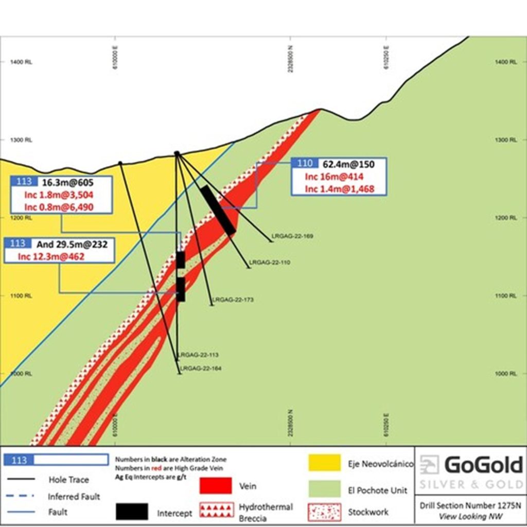
Figure 1: Cross Section – LRGAG-22-113 (CNW Group/GoGold Resources Inc.)
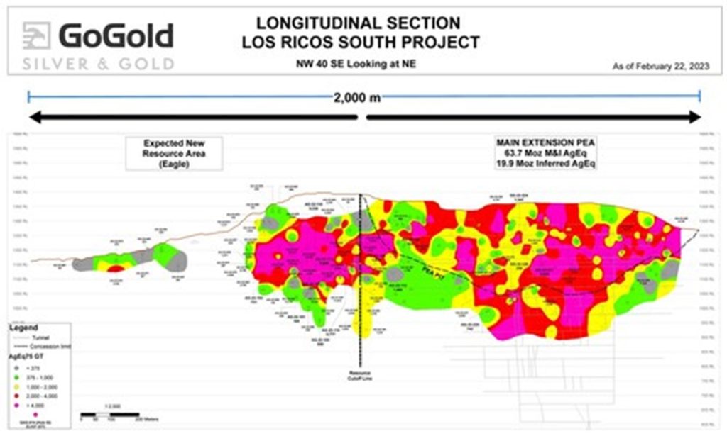
Figure 2: Eagle + Main Area Grade Thickness Longitudinal Section (CNW Group/GoGold Resources Inc.)
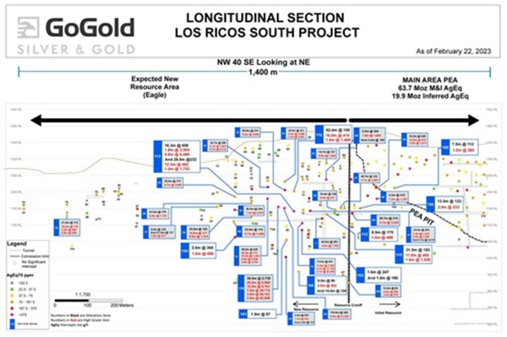
Figure 3: Eagle Longitudinal Section (CNW Group/GoGold Resources Inc.)
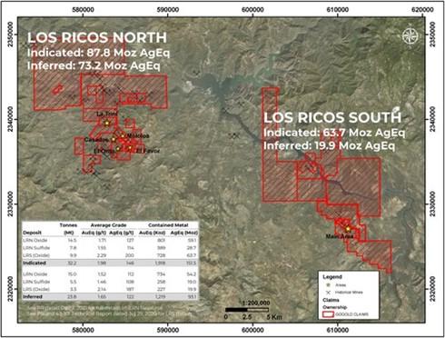
Figure 4: Los Ricos District Overview (CNW Group/GoGold Resources Inc.)
Updated Geological Model Defines a Larger, Higher-Confidence Underground Gol... READ MORE
Minaurum Silver Inc. (TSX-V: MGG) (OTCQX: MMRGF) is pleased to... READ MORE
The first hole of the 2026 program drilled through to a mineraliz... READ MORE
Abcourt Mines Inc. (TSX-V: ABI) (OTCQB: ABMBF) is pleased to anno... READ MORE
Aya Gold & Silver Inc. (TSX: AYA) (NASDAQ: AYA) is pleased t... READ MORE


