


![]()
GoGold Resources Inc. (TSX: GGD) (OTCQX: GLGDF) is pleased to announce first assay results have been received from its near-mine 2025 exploration program conducted on the Eagle and Abra (Main) Zones of the Silver-gold Los Ricos South Project located in Jalisco, Mexico. Drill targeting was based on reconstruction of the historical Cinco Minas Mine and a new IP geophysics survey conducted this year. Assay results from geotechnical holes in the Eagle Zone are also discussed.
“We’re pleased with these initial results of our near-mine exploration program. The objective was to drill some scouting exploration holes deeper than our current Resource and south of the current Resource in a faulted off section of the vein. We were successful in hole 318 as it demonstrated strong mineralization continues deeper below our current Resources. Also, a highlight of the drilling was hole 324 which not only located the faulted off section of the vein outside of the Resource but yielded strong gold and silver grades and widths. Another significant hole is hole 337, located in Cerro Colorado which is south of known mineralization and could represent a new ore shoot which we will target with further drilling,” said Brad Langille, President and CEO. “Hole LRSGT-23-001 was drilled for geotechnical purposes within the current Resource area, but after publication. This is confirmatory of the high grade and large widths of the Eagle Zone.”
Highlights from the drilling program include the following:
Table 1: Drill Hole Results
| Hole ID | Area / Vein | From | To | Length1 | Au | Ag | AuEq2 | AgEq2 |
| (m) | (m) | (m) | (g/t) | (g/t) | (g/t) | (g/t) | ||
| LRGG-24-318 | Los Ricos Vein | 691.18 | 701.90 | 10.72 | 1.234 | 122.7 | 2.87 | 215.2 |
| including | 698.10 | 698.85 | 0.75 | 6.700 | 401.0 | 12.05 | 903.5 | |
| LRGG-25-321 | Los Ricos Vein | 222.50 | 234.00 | 11.50 | 0.640 | 78.8 | 1.69 | 126.8 |
| including | 222.50 | 227.60 | 5.10 | 0.893 | 80.1 | 1.96 | 147.0 | |
| LRGG-25-322 | Los Ricos Vein | 310.66 | 318.00 | 7.34 | 0.202 | 130.1 | 1.94 | 145.3 |
| including | 313.50 | 318.00 | 4.50 | 0.258 | 182.5 | 2.69 | 201.9 | |
| LRGG-25-324 | Los Ricos Vein | 227.10 | 250.15 | 23.05 | 1.491 | 122.6 | 3.13 | 234.4 |
| including | 231.50 | 232.89 | 1.39 | 7.417 | 477.4 | 13.78 | 1,033.7 | |
| LRGG-25-325 | Los Ricos Vein | 237.50 | 238.50 | 1.00 | 0.440 | 97.0 | 1.73 | 130.0 |
| LRGG-25-327 | Los Ricos Vein | 452.00 | 495.45 | 43.45 | 0.218 | 54.0 | 0.94 | 70.4 |
| including | 469.65 | 470.65 | 1.00 | 0.025 | 656.0 | 8.77 | 657.9 | |
| LRGG-25-328 | Los Ricos Vein | 235.00 | 257.04 | 22.04 | 0.181 | 41.9 | 0.74 | 55.5 |
| including | 256.50 | 257.04 | 0.54 | 1.940 | 346.0 | 6.55 | 491.5 | |
| LRGG-25-330 | Los Ricos Vein | 314.65 | 315.15 | 0.50 | 0.460 | 206.0 | 3.21 | 240.5 |
| LRGG-25-333 | Los Ricos Vein | 183.30 | 185.40 | 2.10 | 0.832 | 36.9 | 1.32 | 99.3 |
| LRGG-25-334 | Los Ricos Vein | 230.50 | 231.65 | 1.15 | 1.061 | 48.4 | 1.71 | 127.9 |
| and | 241.70 | 242.70 | 1.00 | 1.344 | 236.4 | 4.50 | 337.2 | |
| LRGG-25-335 | Los Lamas Vein | 251.20 | 252.15 | 0.95 | 1.850 | 137.0 | 3.68 | 275.8 |
| and | 262.70 | 267.25 | 4.55 | 0.395 | 71.0 | 1.34 | 100.6 | |
| LRGG-25-336 | Cerro Col. Vein | 12.30 | 23.61 | 11.31 | 0.814 | 20.9 | 1.09 | 82.0 |
| including | 17.10 | 22.58 | 5.48 | 0.950 | 26.5 | 1.30 | 97.7 | |
| LRGG-25-337 | Cerro Col. Vein | 27.55 | 37.00 | 9.45 | 3.754 | 21.7 | 4.04 | 303.3 |
| including | 33.50 | 35.00 | 1.50 | 10.740 | 43.8 | 11.32 | 849.3 | |
| LRGG-25-339 | Cerro Col. Vein | 4.15 | 6.40 | 2.25 | 0.723 | 49.0 | 1.38 | 103.2 |
| The following holes are geotechnical holes drilled after Resource was published, and are within current Resource area: | ||||||||
| LRSGT-23-001 | Los Ricos Vein | 129.15 | 150.40 | 21.25 | 12.76 | 2,077.0 | 40.46 | 3,034.2 |
| including | 131.20 | 132.62 | 1.42 | 173.55 | 28,094.0 | 548.14 | 41,110.2 | |
| GT-PFS-23-001 | Los Ricos Vein | 133.85 | 139.00 | 5.15 | 0.71 | 173.9 | 3.03 | 227.1 |
| including | 134.90 | 136.28 | 1.38 | 1.86 | 334.4 | 6.32 | 474.0 | |
| GT-PFS-23-003 | Los Ricos Vein6 | 120.68 | 146.67 | 25.99 | 0.86 | 89.1 | 2.05 | 153.5 |
| including6 | 122.95 | 130.50 | 7.55 | 3.09 | 286.0 | 6.90 | 517.8 | |
| including6 | 122.95 | 129.59 | 6.64 | 3.27 | 313.0 | 7.45 | 558.5 | |
| GT-PFS-23-004 | Los Ricos Vein | 60.00 | 92.10 | 32.10 | 3.18 | 292.1 | 7.08 | 531.0 |
| including | 64.00 | 65.60 | 1.60 | 20.11 | 2,792.5 | 57.35 | 4,300.9 | |
| GT-PFS-23-005 | Los Ricos Vein6 | 66.30 | 93.60 | 27.30 | 0.36 | 45.8 | 0.97 | 72.8 |
| including6 | 75.00 | 80.60 | 5.60 | 0.94 | 77.1 | 1.97 | 147.7 | |
| GT-PFS-23-OP4 | Los Ricos Vein6 | 101.15 | 115.40 | 11.80 | 2.62 | 289.1 | 6.48 | 485.8 |
| including6 | 106.25 | 115.40 | 6.70 | 4.60 | 489.9 | 11.13 | 834.5 | |
| GT-PFS-23-OP5 | Los Ricos Vein | 40.00 | 54.90 | 14.90 | 0.37 | 58.9 | 1.16 | 87.0 |
| Including | 46.20 | 47.20 | 1.00 | 1.09 | 170.0 | 3.36 | 251.8 | |
| GT-PFS-23-005 | Los Ricos Vein6 | 66.30 | 93.60 | 27.30 | 0.36 | 45.8 | 0.97 | 72.8 |
| including | 46.20 | 47.20 | 1.00 | 1.09 | 170.0 | 3.36 | 251.8 | |
Summary
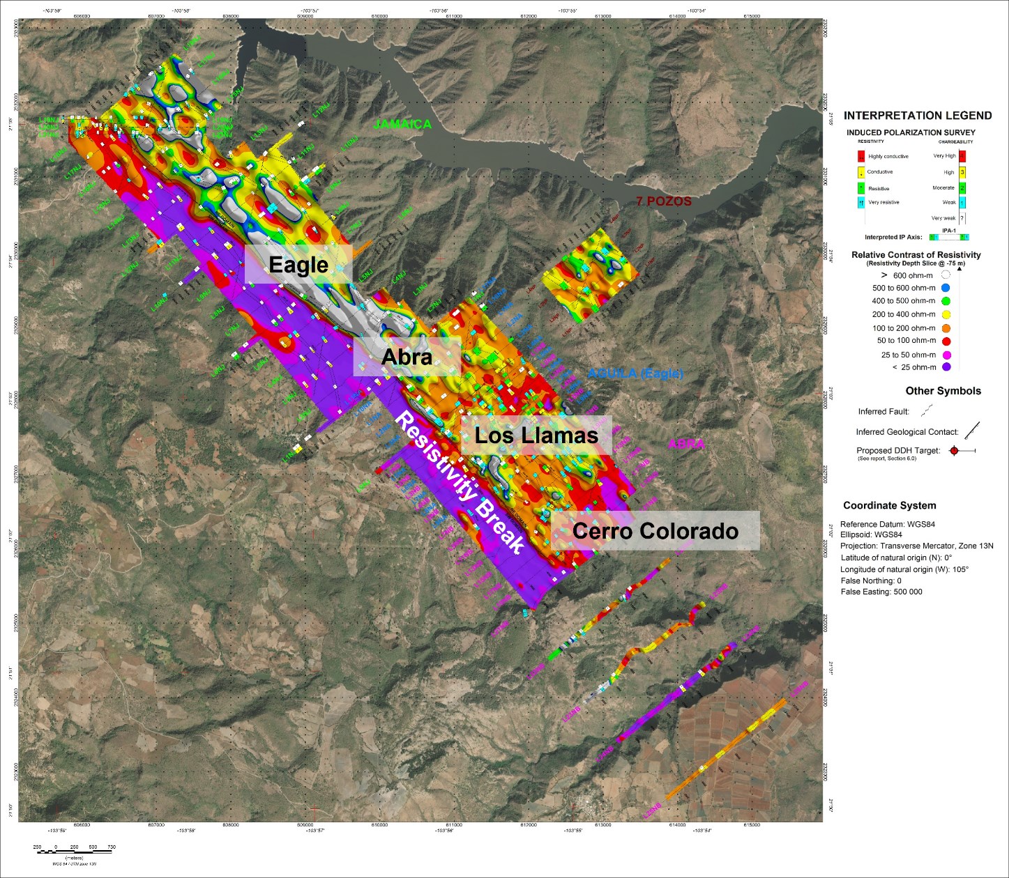
In early 2025, the exploration team began a new IP survey to extend the coverage south of the El Abra deposit to the Cerro Colorado deposit (see Figure 2). The new data, combined with the 2022 IP survey, provides continuous detailed information along the El Abra structure over a strike length of 7km. Based on a re-evaluation of historical data and the new IP geophysics, a systematic step-out drilling program to test the down dip, the southern strike extension of the Abra Zone towards Los Lamas, and the Cerro Colorado deposit was started in January 2025.
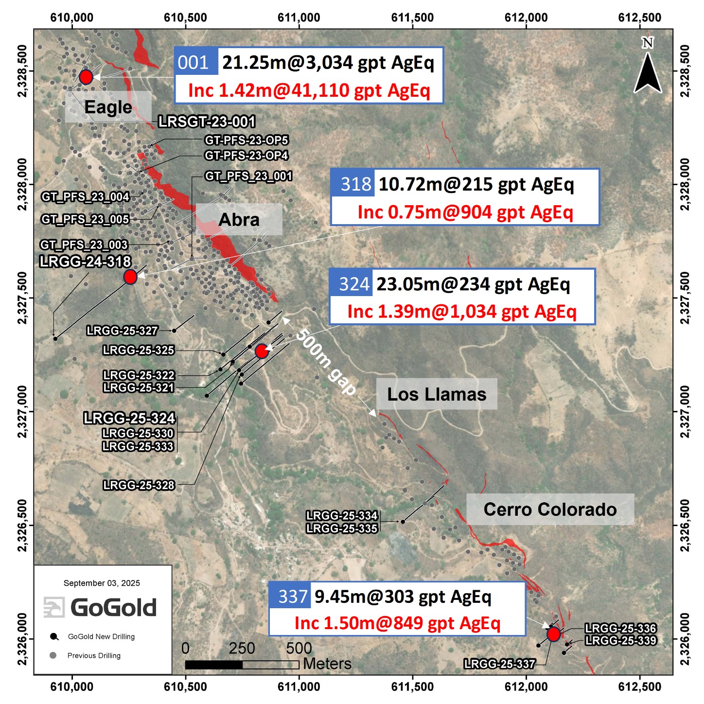
The goal of this drilling is to extend the known mineral occurrence at the south end of the historically mined Cinco Minas one kilometer to the Los Llamas Zone all the way to the south at Cerro Colorado, a total strike length of 3.5km. The drill holes in this release were not included in the initial Mineral Resource Estimate (“MRE”) for Los Ricos South released on January 6, 2025.
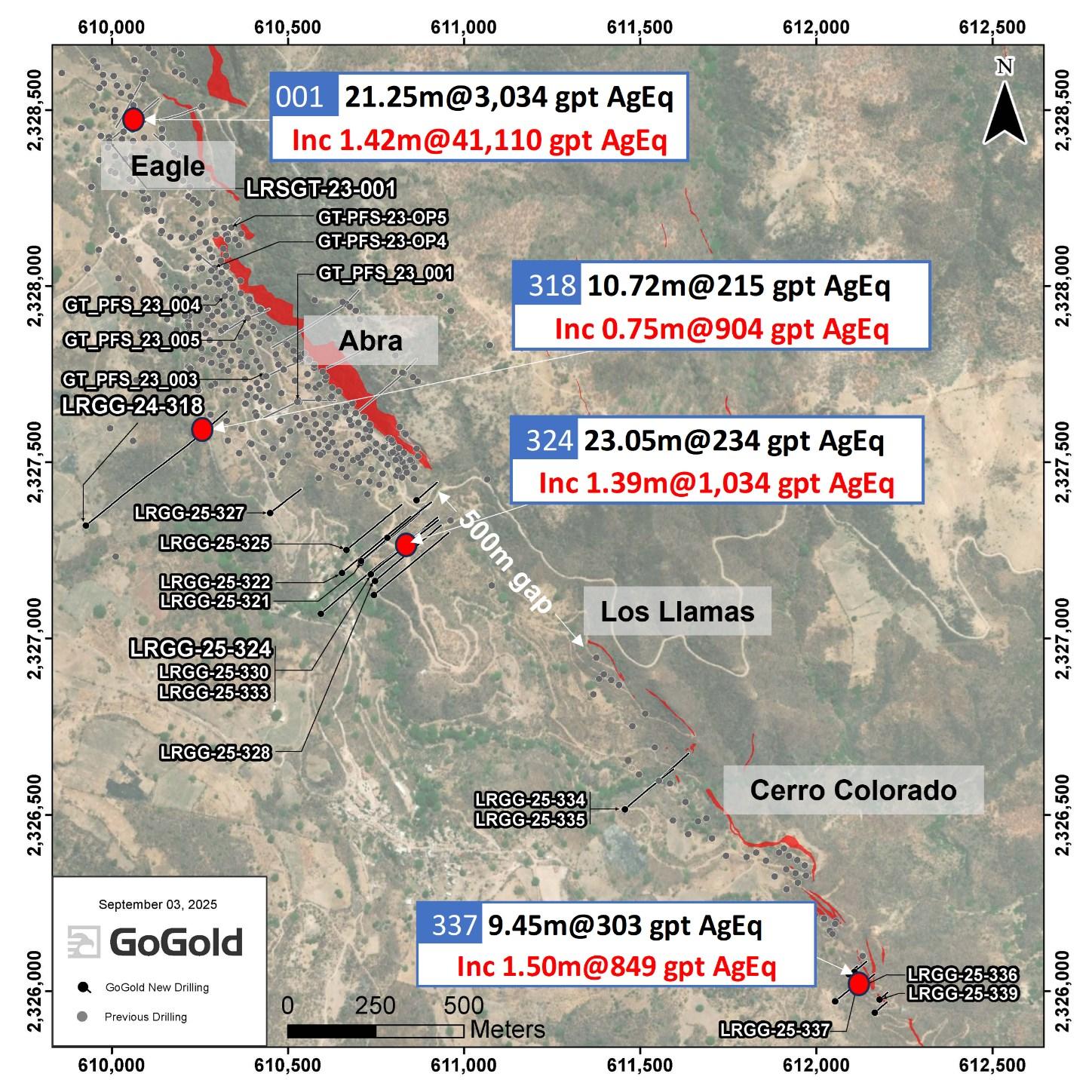
Figure 1: 2025 Exploration Drilling – Los Ricos Plan View
To view an enhanced version of this graphic, please visit:
https://images.newsfilecorp.com/files/1683/265564_3f2cf4ad74ba2a00_001full.jpg
Figure 2: 2025 IP Survey – Plan View
Induced polarization is industry standard in exploring for low sulfidation epithermal deposits, and particularly resistivity shows a pronounced break between the El Pochete and Eje Volcanics, the known host of the Los Ricos Vein System. This break can be traced for a total of 7km from the north of Eagle to the far south of Cerro Colorado.

Figure 2: 2025 IP Survey – Plan View
To view an enhanced version of this graphic, please visit:
https://images.newsfilecorp.com/files/1683/265564_3f2cf4ad74ba2a00_002full.jpg
This prospective break, along with a refreshed look at historical mining records, show the area to be prospective to the south of the Abra Zone and down dip of the current FS designed stopes.
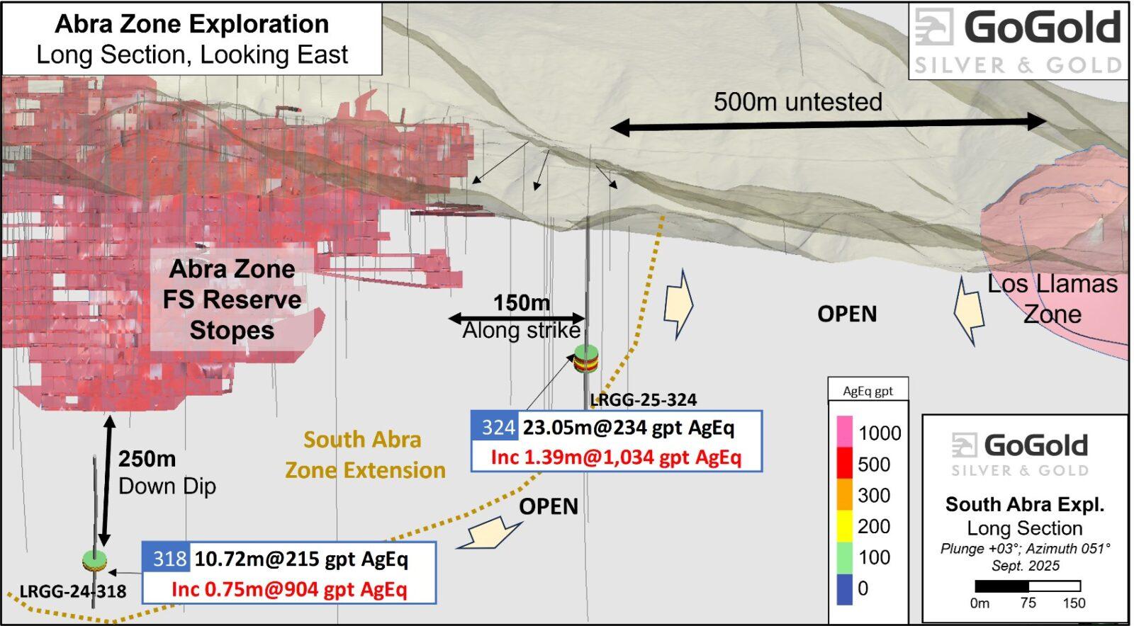
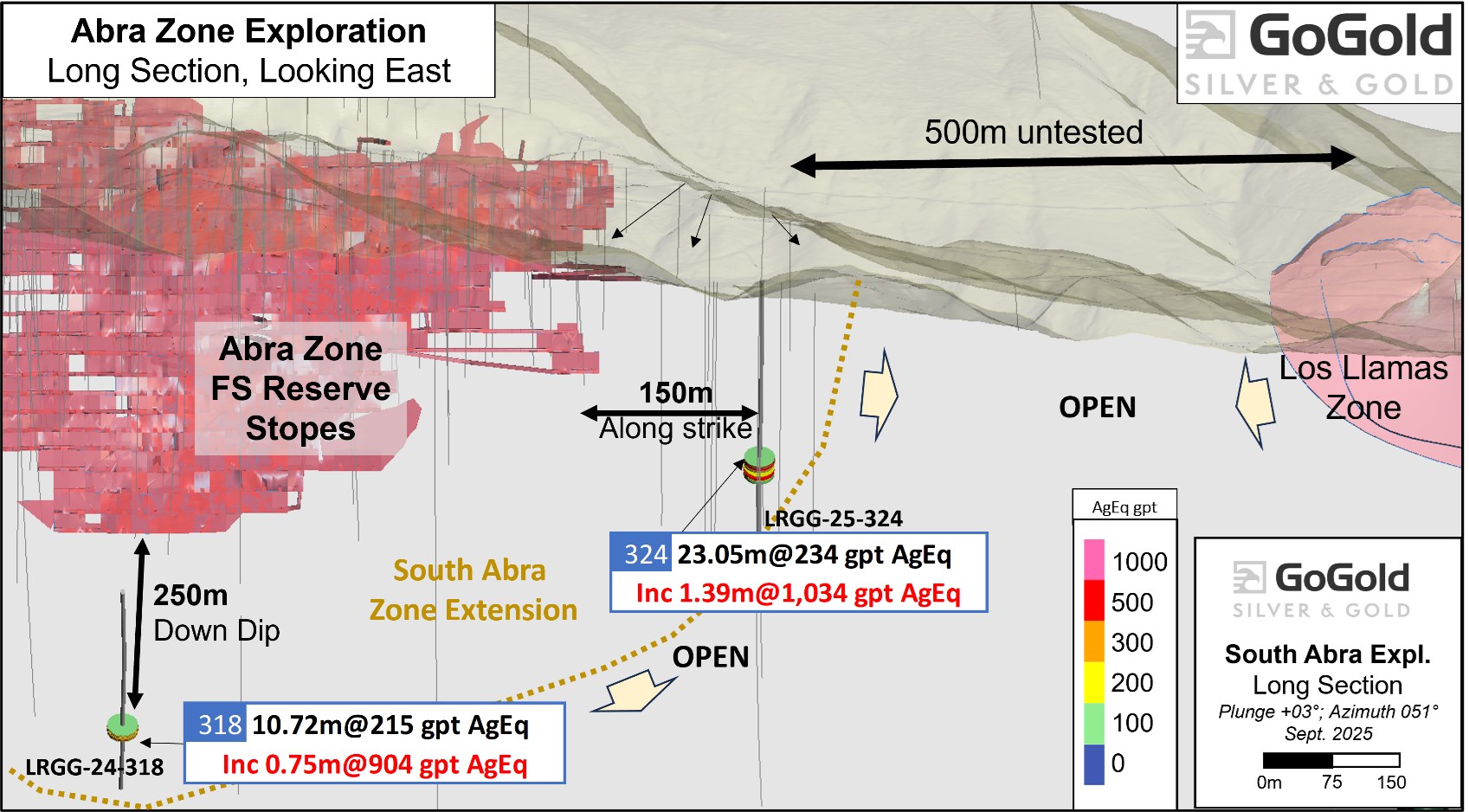
Figure 3: Longitudinal Section – Near Mine Drilling
To view an enhanced version of this graphic, please visit:
https://images.newsfilecorp.com/files/1683/265564_3f2cf4ad74ba2a00_003full.jpg
Assay results from drill hole LRGG-24-318 show the high grade Abra Zone extends 250m down dip of the deepest Feasibility Study designed stopes, offering excellent expansion potential. Whereas, assay results from LRGG-25-324 show an extension of the Abra Zone 150m south of the last historical mining activity. There remains over 500m of prospective ground untested between DDH 324 and the Los Llamas Zone, believed to be a continuation of the Abra Zone.
Geotechnical Drilling
Based on the recommendations from WSP (retained for the 2024 Feasibility Study) the Company completed additional geotechnical drill holes for the proposed Open Pit and Underground Mine Plans. Holes were completed either, 1) crossing the zone, 2) entirely in FW, 3) entirely in HW or 4) drilled down the vein/HW (e.g., GT_PFS_23_002). Only holes that crossed the Zone were sampled. Geotechnical holes were used for both Resource Definition and geotechnical purposes and confirm the presence of the high-grade Abra and Eagle Zones. These drill holes were not utilized in the updated MRE dated January 16, 2025.
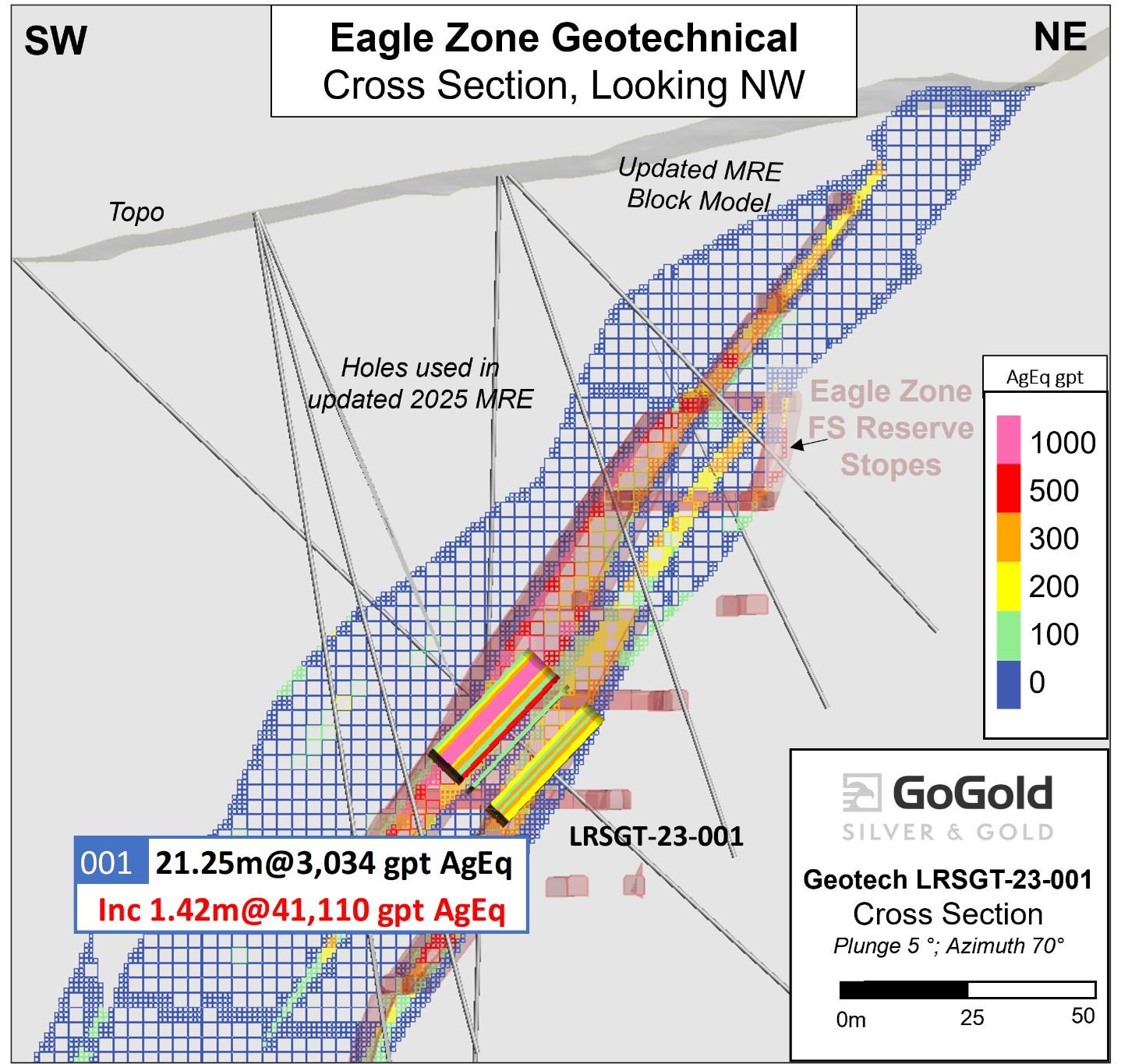
Figure 4: Cross Section – Geotechnical Drilling for Resource
To view an enhanced version of this graphic, please visit:
https://images.newsfilecorp.com/files/1683/265564_3f2cf4ad74ba2a00_004full.jpg
Table 2: Drill Hole Locations
| Hole ID | Easting | Northing | Elevation | Length | Azimuth | Dip | Type |
| LRSGT-23-001 | 609992 | 2328411 | 1260 | 257 | 50 | -45 | Geotechnical |
| GT-PFS-23-OP1 | 610528 | 2327672 | 1282 | 170 | 245 | -50 | Geotechnical |
| GT-PFS-23-OP2 | 610828 | 2327753 | 1423 | 150 | 45 | -70 | Geotechnical |
| GT-PFS-23-OP3 | 610666 | 2327951 | 1472 | 151 | 45 | -70 | Geotechnical |
| GT-PFS-23-OP4 | 610292 | 2328052 | 1308 | 115 | 310 | -60 | Geotechnical |
| GT-PFS-23-OP5 | 610339 | 2328166 | 1349 | 101 | 45 | -70 | Geotechnical |
| GT_PFS_23_001 | 610528 | 2327676 | 1283 | 252 | 90 | -65 | Geotechnical |
| GT_PFS_23_002 | 610775 | 2327544 | 1259 | 201 | 30 | -80 | Geotechnical |
| GT_PFS_23_003 | 610439 | 2327744 | 1274 | 250 | 65 | -65 | Geotechnical |
| GT_PFS_23_004 | 610321 | 2327972 | 1288 | 220 | 30 | -80 | Geotechnical |
| GT_PFS_23_005 | 610386 | 2327909 | 1294 | 151 | 65 | -65 | Geotechnical |
| GT_PFS_23_006 | 610665 | 2327949 | 1471 | 442 | 240 | -55 | Geotechnical |
| GT_PFS_23_007 | 610828 | 2327753 | 1423 | 421 | 230 | -60 | Geotechnical |
| GT_PFS_23_008 | 610188 | 2328372 | 1313 | 251 | 310 | -70 | Geotechnical |
| GT_PFS_23_009 | 610253 | 2328508 | 1384 | 351 | 250 | -70 | Geotechnical |
| GT_PFS_23_010 | 610089 | 2328587 | 1298 | 248 | 210 | -50 | Geotechnical |
| GT_PFS_23_011 | 610747 | 2327839 | 1455 | 452 | 240 | -70 | Geotechnical |
| LRGG-24-318 | 609926 | 2327320 | 1253 | 785 | 50 | -55 | Exploration |
| LRGG-25-319 | 610865 | 2327392 | 1235 | 123 | 50 | -50 | Exploration |
| LRGG-25-320 | 610782 | 2327286 | 1212 | 220 | 50 | -50 | Exploration |
| LRGG-25-321 | 610706 | 2327215 | 1151 | 342 | 50 | -50 | Exploration |
| LRGG-25-322 | 610653 | 2327186 | 1150 | 389 | 50 | -50 | Exploration |
| LRGG-25-323 | 610707 | 2327220 | 1152 | 373 | 50 | -50 | Exploration |
| LRGG-25-324 | 610735 | 2327183 | 1152 | 390 | 50 | -50 | Exploration |
| LRGG-25-325 | 610666 | 2327251 | 1153 | 319 | 50 | -50 | Exploration |
| LRGG-25-326 | 610593 | 2327071 | 1149 | 597 | 50 | -60 | Exploration |
| LRGG-25-327 | 610449 | 2327355 | 1208 | 635 | 50 | -80 | Exploration |
| LRGG-25-328 | 610741 | 2327164 | 1151 | 387 | 50 | -50 | Exploration |
| LRGG-25-329 | 610742 | 2327123 | 1142 | 385 | 50 | -45 | Exploration |
| LRGG-25-330 | 610733 | 2327184 | 1153 | 361 | 50 | -55 | Exploration |
| LRGG-25-331 | 610732 | 2327183 | 1153 | 360 | 50 | -59 | Exploration |
| LRGG-25-332 | 610732 | 2327183 | 1153 | 430 | 50 | -66 | Exploration |
| LRGG-25-333 | 610733 | 2327184 | 1153 | 351 | 50 | -46 | Exploration |
| LRGG-25-334 | 611456 | 2326517 | 1096 | 361 | 50 | -47 | Exploration |
| LRGG-25-335 | 611456 | 2326516 | 1096 | 350 | 50 | -60 | Exploration |
| LRGG-25-336 | 612127 | 2326018 | 1041 | 71 | 50 | -45 | Exploration |
| LRGG-25-337 | 612118 | 2326012 | 1039 | 85 | 50 | -82 | Exploration |
| LRGG-25-338 | 612164 | 2325942 | 1018 | 66 | 50 | -45 | Exploration |
| LRGG-25-339 | 612182 | 2325970 | 1029 | 44 | 50 | -45 | Exploration |
Procedure, Quality Assurance / Quality Control and Data Verification
The diamond drill core (HQ size) is geologically logged, photographed and marked for sampling. When the sample lengths are determined, the full core is sawn with a diamond blade core saw with one half of the core being bagged and tagged for assay. The remaining half portion is returned to the core trays for storage and/or for metallurgical test work.
The sealed and tagged sample bags are transported to the ALS Chemex facility in Zacatecas, Mexico. ALS Chemex crushes the samples and prepares 200-300 gram pulp samples with ninety percent passing Tyler 150 mesh (106μm). The pulps are assayed for gold using a 30-gram charge by fire assay (Code AA23) and over limits greater than 10 grams per tonne are re-assayed using a gravimetric finish (Code ME-GRAV21). Silver and multi-element analysis is completed using total digestion (Code ME-ICP61 Total Digestion ICP). Over limits greater than 100 grams per tonne silver are re-assayed using a gravimetric finish (ME-GRA21).
Quality assurance and quality control procedures monitor the chain-of-custody of the samples and includes the systematic insertion and monitoring of appropriate reference materials (certified standards, blanks and duplicates) into the sample strings. The results of the assaying of the QA/QC material included in each batch are tracked to ensure the integrity of the assay data. All results stated in this announcement have passed GoGold’s QA/QC protocols.
Qualified Person
David R. Duncan, P. Geo., V.P. Exploration of the Corporation, is the Qualified Person for GoGold as defined under National Instrument 43-101. Mr. Duncan has reviewed and approved the scientific and technical information in this press release.
Los Ricos District Exploration Projects
The Company’s two development projects at its Los Ricos Property are in Jalisco state, Mexico. The Los Ricos South Project began in March 2019 and an initial Mineral Resource was announced on July 29, 2020, which disclosed a Measured & Indicated Mineral Resource of 63.7 million ounces AgEq grading 199 g/t AgEq contained in 10.0 million tonnes, and an Inferred Mineral Resource of 19.9 million ounces AgEq grading 190 g/t AgEq contained in 3.3 million tonnes. An initial PEA on the project was announced on January 20, 2021, indicating an NPV5% of US$295M. On January 16, 2025, the company announced a feasibility study which included a front-end engineering design which outlined an NPV5% of US$355M.
The Los Ricos North Project was launched in March 2020 and an initial Mineral Resource was announced on December 7, 2021, which disclosed an Indicated Mineral Resource of 87.8 million ounces AgEq grading 122 g/t AgEq contained in 22.3 million tonnes, and an Inferred Mineral Resource of 73.2 million ounces AgEq grading 111 g/t AgEq contained in 20.5 million tonnes. An initial PEA on the project was announced on May 17, 2023, indicating an NPV5% of US$413M.
About GoGold Resources
GoGold Resources (TSX: GGD) is a Canadian-based silver and gold producer focused on operating, developing, exploring and acquiring high quality projects in Mexico. The Company operates the Parral Tailings mine in the state of Chihuahua and has the Los Ricos South and Los Ricos North exploration and development projects in the state of Jalisco. Headquartered in Halifax, NS, GoGold is building a portfolio of low cost, high margin projects. For more information visit gogoldresources.com.
Hudbay Minerals Inc. (TSX:HBM) (NYSE: HBM) today released its ann... READ MORE
Strategic acquisition of an established operating gold mine, loca... READ MORE
Cerro de Pasco Resources Inc. (TSX-V: CDPR) (OTCQB: GPPRF) (FRA: ... READ MORE
The Garneau Titanium Project Features Ilmenite-Rich Boulder with ... READ MORE
ValOre Metals Corp. (TSX‐V: VO) (OTCQB: KVLQF) (Frankfurt: KEQ0... READ MORE


