


Gladiator Metals Corp (TSX-V: GLAD) (OTCQB: GDTRF) (FSE: ZX7) is pleased to announce results of its recent eleven hole (2,695m) drill program at its Arctic Chief prospect evaluating near surface high-grade copper-gold skarn mineralization at the southern extent of the 2-km long Arctic Chief Trend, a high priority target within the Company’s 35km long Whitehorse Copper Belt.
Mineralized intercepts in first pass drilling point to an emerging high-grade Copper & Gold discovery at the Arctic Chief prospect within the Arctic Chief Mineralized Trend; further drilling is planned to follow up, with mineralization remaining open in all directions.
Significant drill intercepts from recent drilling at the Arctic Chief prospect returned significant high-grade copper and gold, including:
These results are in conjunction with recently returned high-grade intercepts 1.4 km to the north at the Best Chance prospect within the Arctic Chief Trend1.
1 Refer Announcement “Exploration to Commence at the Artic Chief Trend” – July 15, 2025
Gladiator CEO Jason Bontempo commented:
“Initial drilling at the Arctic Chief trend has returned some of the most significant gold values returned by Gladiator to date within the Whitehorse Copper Project, with gold assays being returned up to 5.22 g/t Au, coincident with copper and silver mineralization.
These multiple, underexplored magnetite-copper-gold skarn bodies are close to surface and open in all directions.
These results at Arctic Chief, when viewed in conjunction with results returned from the Best Chance1 prospect last month (~1.4km to the north), highlight the underexplored, near surface resource potential of this emerging mineralized corridor. The Arctic Chief Trend is only 12km north of the historical Little Chief deposit where previous production delivered 267,500,000 pounds copper, 225,000 ounces of gold and 2,838,000 ounces of silver from 10.5 million tons of mineralized material milled (Watson, 1984).
The geological continuity of the >2km long Arctic Chief mineralized trend has been mapped on surface and is supported by recently returned gravity datasets. Gladiator will be expanding drilling in the target area as part of its fully funded 2025 exploration program.”
ARCTIC CHIEF DRILLING
Gladiator has received assay results for 11 diamond drill holes for 2,694.76m (Figure 1 and Table 1) at the Arctic Chief prospect within the 2.5km long Arctic Chief Trend. This drill program was designed to:
Significant drill intercepts from recent drilling conducted at Arctic Chief prospect include (please refer Table 1 for all results):
Mineralization reported is consistent in style with high-grade copper-gold-magnetite skarn mineralization previously mined at the Arctic Chief deposit. Encouragingly four, shallow, sub parallel zones of magnetite-copper-gold skarn mineralisation have been identified by initial drilling at the Arctic Chief prospect. Mineralization on all four magnetite skarn bodies remains open in all directions with all intercepts reported from vertical depths less than 150m (refer to Figure 1 below). As such these results highlight the underexplored resource potential of the >2km long Arctic Chief mineralized trend that has been mapped on surface but remains predominantly undrilled.
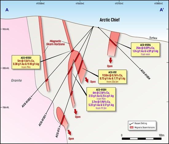
Figure 1 – Geological Section A-A’ through recent drilling at Arctic Chief showing multiple, shallow, underexplored magnetite-copper-gold skarns identified. Significant intercepts shown only. For full table of results please refer to Table 1. For location of Section A-A’ please refer to Figure 2 below.
These results, when taking into account the recent high-grade intercepts 1.4 km to the north at the Best Chance prospect within the Arctic Chief Trend (refer to Figure 2), suggest an emerging discovery within the Whitehorse Copper Project.
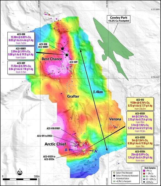
Figure 2 – Drill Collar locations from recent drilling at Arctic Chief and Best Chance overlaid over recently completed gravity survey image completed over the “Arctic Chief Trend”, with a comparison to the Cowley mineralized shell for size comparison. Significant intercepts shown only. For full table of results please refer to Table 1.
Significant drill intercepts from recent drilling conducted at Best Chance include1:
The geological continuity between the Best Chance and Arctic Chief prospects on the Arctic Chief Trend is supported by surface mapping and a recently completed gravimetric survey (May 2025) which highlighted a broadly NS-oriented, 2-km long trend of elevated density response linking historically explored areas within the Arctic Chief Trend.
This higher density trend links historical exploration areas and workings such as Arctic Chief, Best Chance and Grafter. This suggests these areas may form part of a larger connected system within the 2.5-km long trend, with drilling completed by Gladiator at Arctic Chief, returning Gladiator’s best gold intersections to date.
These results are highly encouraging; and additional geological fieldwork is currently underway to verify the potential significance of this recently identified density anomaly that lies within the broader Arctic Chief Trend. Planned and fully funded 2025 drilling will be focused on defining mineralized continuity of shallow, copper-gold skarn bodies within the extensive trend.
| Hole ID | Depth | East | North | Dip | Azim | Note | From | To | Interval (m) |
Cu (%) |
Au (g/t) |
Ag (g/t) |
Mo (ppm) |
| ACG-010 | 222.50 | 493,595 | 6,725,070 | -44 | 296 | 122.63 | 132.00 | 9.37 | 0.77 | 0.51 | 4.02 | 1 | |
| Incl. | 128.00 | 132.00 | 4.00 | 1.46 | 0.96 | 8.30 | 1 | ||||||
| 176.00 | 184.00 | 8.00 | 0.35 | 0.14 | 1.90 | 2 | |||||||
| ACG-010D1 | 240.00 | 493,596 | 6,725,071 | -55 | 319 | NSA | |||||||
| ACG-011 | 213.36 | 493,594 | 6,725,012 | -44 | 268 | NSA | |||||||
| ACG-011D1 | 280.00 | 493,594 | 6,725,012 | -73 | 271 | 74.00 | 76.00 | 2.00 | 0.00 | 4.15 | 0.00 | 2 | |
| 202.41 | 224.51 | 22.10 | 0.76 | 0.51 | 5.98 | 3 | |||||||
| Incl. | 202.41 | 208.00 | 5.59 | 1.65 | 0.67 | 14.45 | 0 | ||||||
| And | 218.00 | 221.50 | 3.50 | 1.35 | 1.88 | 8.99 | 0 | ||||||
| ACG-011D2 | 249.94 | 493,594 | 6,725,012 | -85 | 132 | NSA | |||||||
| ACG-011D3 | 262.13 | 493,594 | 6,725,012 | -71 | 305 | NSA | |||||||
| ACG-012 | 269.75 | 493,633 | 6,724,940 | -71 | 272 | 76.00 | 86.00 | 10.00 | 0.23 | 0.11 | 2.64 | 24 | |
| 103.80 | 106.00 | 2.20 | 0.92 | 0.40 | 10.00 | 0 | |||||||
| 236.50 | 246.00 | 9.50 | 0.76 | 0.73 | 7.77 | 2 | |||||||
| ACG-012D1 | 252.98 | 493,633 | 6,724,940 | -61 | 270 | 74.00 | 78.00 | 4.00 | 0.14 | 0.45 | 1.20 | 2 | |
| 95.00 | 101.00 | 6.00 | 2.16 | 2.13 | 21.40 | 1 | |||||||
| Incl. | 97.00 | 101.00 | 4.00 | 3.15 | 2.92 | 31.10 | 1 | ||||||
| 111.30 | 115.00 | 3.70 | 1.96 | 5.22 | 5.17 | 2 | |||||||
| ACG-012D2 | 237.74 | 493,633 | 6,724,939 | -49 | 270 | 25.00 | 31.00 | 6.00 | 0.42 | 0.14 | 4.47 | 6 | |
| 79.00 | 84.00 | 5.00 | 1.54 | 0.38 | 11.18 | 1 | |||||||
| Incl. | 80.20 | 84.00 | 3.80 | 1.97 | 0.44 | 14.21 | 1 | ||||||
| ACG-012D3 | 313.94 | 493,628 | 6,724,940 | -64 | 231 | NSA | |||||||
| ACG-012D4 | 152.42 | 493,645 | 6,724,947 | -46 | 97 | 44.00 | 69.00 | 25.00 | 0.59 | 1.24 | 4.59 | 0 | |
| Incl. | 55.00 | 69.00 | 14.00 | 0.82 | 2.06 | 7.39 | 0 | ||||||
| And | 63.00 | 69.00 | 6.00 | 1.11 | 4.06 | 13.23 | 0 | ||||||
Table 1: Recently returned drill assay results from Arctic Chief. Note that the quoted Intersections are reported as interval widths and not true width. True widths of the intersected mineralized skarn system is complex, with different grade distributions present related to the form of the contact between the granodiorite and sedimentary units as well different vein generations and orientations within the various intervals.
FURTHER INFORMATION
In May 2025, Aurora Geosciences completed ground-based gravity surveys on behalf of Gladiator, covering the Arctic Chief Trend. The program was designed to assist in target definition and support drill hole planning, particularly in areas of shallow till cover. The survey was conducted on 100m x 20m survey spacings with areas of early interest closed to 50m x 20m spacing. Data was interpreted and inverted by Southern Geosciences Ltd (Perth, Australia).
The gravity survey measures variations in the Earth’s gravitational field to identify subsurface variations in density. Copper skarn mineralization in the Whitehorse district has a significantly higher density than surrounding country rock and so sub-surface anomalism provides information for first pass drilling to define if high-density bodies that may represent areas of prospective mineralization.
Instrumentation used in the survey consists of two Scintrex gravimeters and two Leica RTK GPS receivers.
EXPLORATION STRATEGY
The ongoing drilling at Cowley Park is part of a planned 29,000m drill program targeting high-grade copper skarns throughout the Whitehorse Copper Belt before the end of Q4 2025. Drilling is designed with the following objectives:
1 – Advancing Cowley Park to resource definition and expansion:
2 – Exploration drilling at:
Drilling will be supported by planned geophysical programs including Induced Polarization (ongoing), Electromagnetic and Gravity surveys to help refine drill targeting in the prospect areas and highlight undiscovered areas of exploration potential.
THE WHITEHORSE COPPER PROJECT
The Whitehorse Copper Project is an advanced-stage high grade copper, molybdenum, silver and gold skarn exploration project in the Yukon Territory, Canada.
Copper mineralization was first discovered in 1897 on the Whitehorse Copper Belt and comprises over 30 copper-related, primarily skarn occurrences covering an area of 35km long by 5 km wide on the western margin of Whitehorse City, Yukon.
Exploration and mining development have been carried out intermittently since 1897 with the main production era lasting between 1967 and 1982 where production from primarily the Little Chief deposit totalled 267,500,000 pounds copper, 225,000 ounces of gold and 2,838,000 ounces of silver from 10.5 million tons of mineralized material milled (Watson, 1984). The Whitehorse Copper Project is accessible by numerous access roads and trails located within 2 km of the South Klondike Highway and the Alaska Highway. An extensive network of historical gravel exploration and haul roads exists throughout the project area, providing excellent access to the claim package. Access to existing electric power facilities is available through the main Yukon power grid.
Project Highlights
QA / QC
Drilling completed by Gladiator is irregularly spaced to test parts of the mineralized systems, holes were directionally surveyed utilising a North Seeking Gyro direction tool. Drill collars are subsequently surveyed utilising a high-accuracy RTK DGPS or DeviSite system. Diamond drilling is usually cased, then cored utilising HTW diameter before reducing at shallow depth in stable ground to NTW diameter drill core.
Mineralized quoted intersections are reported as interval widths and not true width. True widths of the intersected mineralized skarn system is complex making an estimate of the true width unreliable. This is due to different grade distributions and angle geometries present related to the form or outline of the contact between the granodiorite and sedimentary units as well different vein paragenesis and orientations within the various intervals. Where possible, drilling is conducted perpendicular to interpreted mineralization.
Upon drilling of diamond core, Gladiator undertakes geological logging, marking up of lineal length of the core, recording core recovery, and Geotech measurements such as RQD’s and taking core photographs.
Based on the geological logging, core is then marked up for sampling with a new sampling ticket that matches the submitted sample for analysis at the start of the sample interval, the drill core is then cut in half utilizing a core saw equipped with a diamond saw blade. The core samples are then sent for analysis and the remaining half core retained for future reference. Certified Reference Materials (CRMs) or known blank material is placed within the sampling sequence at a nominal sampling rate of at least 1 in 25 samples to monitor the Laboratory.
Samples are submitted to the Whitehorse based prep facility of ALS Global Laboratory (Canada). Samples subject to this release were crushed to 70% less than 2mm before pulverizing to better than 85% passing <75 microns. Assay pulps are then transported by ALS to the Vancouver (Langley) facility to be analysed. On occasions where the Whitehorse prep facility has reduced capacity to complete preparation of the samples within a timely manner, samples may be forwarded by ALS Global to their Langley facility for preparation utilising the same method as described above.
Samples were then analysed by ALS method ME-ICP61 (34 Element Aqua Regia with ICP-MS finish), with over limits for Cu analysed by method CU-OG62 (Aqua Regia with ICP-MS finish). Au is analysed by ALS method AU-AA25 (Ore Grade Au 30g Fire Assay AA Finish). As part of this process, Gladiator also captures the required sampling metadata to potentially utilize the core and analysis for any future requirements if deemed acceptable. The QA/QC meets the current required standards under reporting instruments, such as National Instrument 43-101. At this point, Gladiator regards the data collected from this exercise as reliable for the purposes of identifying future exploration targets and may be used to inform future drilling and exploration campaigns.
As part of this process, Gladiator also captures the required sampling metadata to potentially utilize the core and analysis for any future requirements if deemed acceptable. Further drilling will need to be completed by Gladiator at some stage to confirm the reliability or usability of this data in the future including but not limited to twinning of reported mineralization. This may be required as Gladiator may not be able to confirm the accuracy of the stated drill collar location or be able to re-enter the holes to confirm depths and undertake directional surveys, or that the QA/QC might not meet the current required standards under reporting instruments, such as National Instrument 43-101. At this point, the Company is treating the data collected from this exercise as reliable for the purposes of identifying future exploration targets and may be used to inform future drilling and exploration campaigns.
References:
Watson P.H. (1984) The Whitehorse Copper Belt – A Compilation. Yukon Geological Survey, Open File 1984-1.(https://data.geology.gov.yk.ca/Reference/42011#InfoTab)
Tenney D. (1981) – The Whitehorse Copper Belt: Mining, Exploration and Geology (1967-1980). (https://ia801705.us.archive.org/23/items/whitehorsecopper00tenn/whitehorsecopper00tenn.pdf)
Qualified Person
All scientific and technical information in this news release has been prepared or reviewed and approved by Kell Nielsen, the Company’s Vice President Exploration, a “qualified person” as defined by NI 43-101.
Hudbay Minerals Inc. (TSX:HBM) (NYSE: HBM) today released its ann... READ MORE
Strategic acquisition of an established operating gold mine, loca... READ MORE
Cerro de Pasco Resources Inc. (TSX-V: CDPR) (OTCQB: GPPRF) (FRA: ... READ MORE
The Garneau Titanium Project Features Ilmenite-Rich Boulder with ... READ MORE
ValOre Metals Corp. (TSX‐V: VO) (OTCQB: KVLQF) (Frankfurt: KEQ0... READ MORE


