Gladiator Metals Corp. (TSX-V: GLAD) (OTCQB: GDTRF) (FSE: ZX7) is excited to announce the latest assay results from Cub East, confirming exceptional high-grade copper, gold, and silver mineralization across multiple drill holes. Step-out drilling has successfully extended high-grade strike continuity to over 80 metres, solidifying Cub East as a major discovery within the Bear Cub trend.
HIGHLIGHTS:
1. Continued high-grade strike continuity confirmed over greater than 80 metres, with 40 metre step-out drilling to the north of the previous sections, returning.
2. Results continue to enhance the scale and grade potential of the system, which remains open in all directions.
Gladiator CEO Jason Bontempo commented:
“These results continue the exciting development of Cub East. Management believes that with continuing success, Gladiator is positioned for significant growth, making it an excellent opportunity for investors looking to capitalize on a rapidly emerging discovery. Drilling at Cub East is actively targeting large-scale coincident gravity and Induced Polarization (IP) anomalies that stretch for at least 900 metres, demonstrating the impressive scale and potential of this prospect.
Drilling continues to intersect substantial copper, gold, and silver mineralization, confirming robust continuity over the known drill extent of 300-metre of strike-and crucially, the system remains open in all directions. This consistent success in drilling not only points to a strong volume and high-grade potential but also highlights the largely untapped greater Bear Cub trend, which spans over 1.5 kilometres.
As additional assay results are anticipated from both Cowley and Cub East, Gladiator is poised for a period filled with significant developments throughout the remainder of 2026. Backed by full funding and progressing with an ambitious drill program of approximately 45,000 metres, the Company is strategically positioned to deliver consistent updates, potentially broaden the scale of its discoveries, management believe if this is achieved, a market re-rating as the larger Whitehorse opportunity unfolds. The rapid advancement at Cub East highlights its emergence as a key asset in Gladiator’s evolving high-grade copper-gold portfolio.
This compelling potential upside, combined with what have been continuous positive drill results, positions Gladiator, in management opinion, as a standout in the exploration space. For forward-looking investors, the current phase of exploration at Cub East offers the opportunity to participate at an early stage in what could become a major mineral discovery.”
SUMMARY
Recently returned assays from Cub East have cemented the Cub East Discovery and proven high-grade strike continuity over greater than 80m, with the completion of 40m step out drilling.
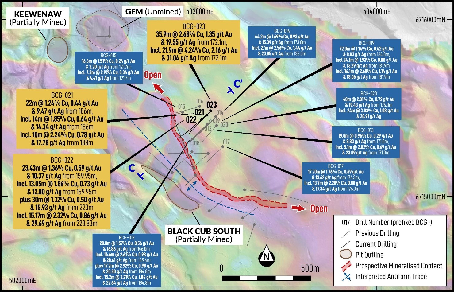
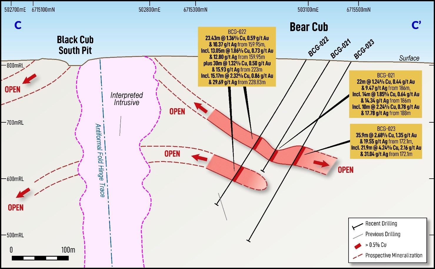
Three step out holes were completed (BCG-021-023) 40 metres north of the most recent line and continue to extend and confirm the extent of high tenor mineralization intersecting strong copper-gold-silver magnetite-skarn mineralization. Results include:
previously released sections included:
CUB EAST
Drilling resumed at Cub East in April 2026, and Gladiator has since completed 9 holes for 2,589m metres, with assay results received for six holes to date (BCG-018 to BCG-023).
Drilling is systematically continuing at Cub East, targeting down-dip and up-dip extensions and along strike within the currently defined 900m (of strike) coincident gravity and Induced Polarization (IP) geophysical anomalies.
These results continue to demonstrate the strong volume and grade potential of the recently discovered Cub East target, while also underscoring the broader, underexplored opportunity across the more than 1.5-kilometre Bear Cub trend. With IP & gravity proving to be an effective targeting tool, additional drilling in this area remains a high priority for Gladiator.
With this in mind, Gladiator completed a 3D IP survey in Late April 2026 conducted across a 1.5 by 1.5km area at Cub East.
Early interpretations from the 3D IP geophysical survey points to a newly defined, non-linear strike extent over 900 metres, representing a potentially significant expansion of the mineralized system.
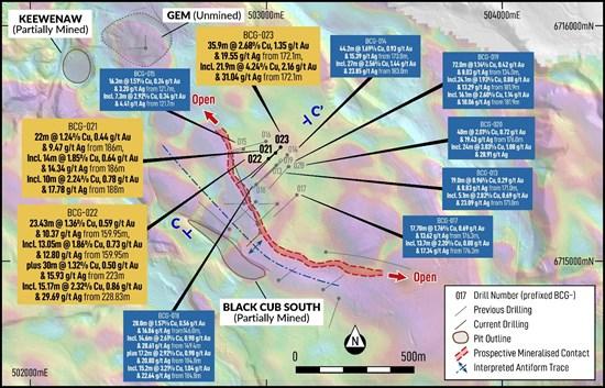
Figure 1: – Plan map of Black Cub over Drone Aeromagnetic Survey. New drill results from Cub East subject to this release highlighted in dark yellow. Please note Section Line showing projection of Figure 2 and 3.
To view an enhanced version of this graphic, please visit:
https://images.newsfilecorp.com/files/1930/300090_5f3daefa147aaa57_002full.jpg
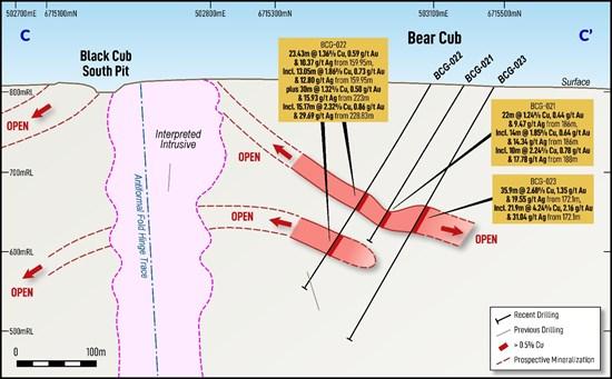
Figure 2: Section (C-C’) through Cub East (Viewing NNW). Drill results from Cub East subject to this release highlighted in dark yellow. Refer to Figure 1 above for the location of section.
To view an enhanced version of this graphic, please visit:
https://images.newsfilecorp.com/files/1930/300090_5f3daefa147aaa57_003full.jpg
| Depth | East | North | Dip | Azim | Note | From | To | Interval (m) |
Cu (%) |
Au (g/t) |
Ag (g/t) |
| BCG-021 | |||||||||||
| 228.60 | 503,036 | 6,715,456 | -59 | 228 | 143.50 | 149.00 | 5.50 | 1.43 | 0.53 | 20.38 | |
| 170.00 | 174.00 | 4.00 | 0.46 | 0.01 | 4.75 | ||||||
| 186.00 | 208.00 | 22.00 | 1.24 | 0.44 | 9.47 | ||||||
| Incl. | 186.00 | 200.00 | 14.00 | 1.85 | 0.64 | 14.34 | |||||
| Incl. | 188.00 | 198.00 | 10.00 | 2.24 | 0.78 | 17.78 | |||||
| BCG-022 | |||||||||||
| 303.28 | 503,007 | 6,715,428 | -59 | 229 | 147.20 | 153.00 | 5.80 | 0.23 | 0.06 | 2.75 | |
| 159.95 | 183.38 | 23.43 | 1.36 | 0.59 | 10.37 | ||||||
| Incl. | 159.95 | 179.00 | 19.05 | 1.49 | 0.59 | 10.74 | |||||
| Incl. | 159.95 | 173.00 | 13.05 | 1.86 | 0.73 | 12.80 | |||||
| 223.00 | 253.00 | 30.00 | 1.32 | 0.50 | 15.93 | ||||||
| Incl. | 228.83 | 244.00 | 15.17 | 2.32 | 0.86 | 29.69 | |||||
| BCG-023 | |||||||||||
| 365.67 | 503,060 | 6,715,479 | -60 | 222 | 142.00 | 162.00 | 20.00 | 0.35 | 0.00 | 0.16 | |
| 172.10 | 208.00 | 35.90 | 2.68 | 1.35 | 19.55 | ||||||
| Incl. | 172.10 | 194.00 | 21.90 | 4.24 | 2.16 | 31.04 | |||||
Table 1: Recently returned drill assay results from Cub East Drill holes (BCG-021-023). Note that the quoted Intersections are reported as interval widths and not true width. True widths of the intersected mineralized skarn system is complex, with different grade distributions present related to the form of the contact between the granodiorite and sedimentary units as well different vein generations and orientations within the various intervals.
COWLEY RESOURCE DELINEATION DRILLING
Drilling commenced at Cowley on 20 April. Gladiator plans to complete at least 8,000 metres of drilling to support resource delineation under Class 3 permit conditions, which allow for greater flexibility and increased drill density both within and beyond the boundaries of the known mineralized system. Using a regularly spaced grid, the program will systematically test mineralized zones and support comprehensive resource definition.
The initial priority is to:
Initial results are expected in the coming weeks.
THE WHITEHORSE COPPER PROJECT
The Whitehorse Copper Project is an advanced-stage high grade copper (Cu), molybdenum (Mo), silver (Ag) and gold (Au) skarn exploration project in the Yukon Territory, Canada.
Copper mineralization was first discovered in 1897 on the Whitehorse Copper Belt and comprises over 30 copper-related, primarily skarn occurrences covering an area of 35 km long by 5 km wide on the western margin of Whitehorse City, Yukon.
Exploration and mining development have been carried out intermittently since 1897 with the main production era lasting between 1967 and 1982 where production from primarily the Little Chief deposit totalled 267,500,000 pounds copper, 225,000 ounces of gold and 2,838,000 ounces of silver from 10.5 million tons of mineralized material milled (Watson, 1984). The Whitehorse Copper Project is accessible by numerous access roads and trails located within 2 km of the South Klondike Highway and the Alaska Highway. An extensive network of historical gravel exploration and haul roads exists throughout the project area, providing excellent access to the claim package. Access to existing electric power facilities is available through the main Yukon power grid.
PROJECT HIGHLIGHTS
QA / QC
Drilling completed by Gladiator is irregularly spaced to test parts of the mineralized systems, holes are directionally surveyed utilising a North Seeking Gyro direction tool. Drill collars are subsequently surveyed utilising a high-accuracy RTK DGPS or DeviSite system. Diamond drilling is usually cased, then cored utilising HTW diameter before reducing at shallow depth in stable ground to NTW diameter drill core.
Mineralized quoted intersections are reported as interval widths and not true width. True widths of the intersected mineralized skarn system is complex making an estimate of the true width unreliable. This is due to different grade distributions and angle geometries present related to the form or outline of the contact between the granodiorite and sedimentary units as well different vein paragenesis and orientations within the various intervals. Where possible, drilling is conducted perpendicular to interpreted mineralization.
Upon drilling of diamond core, Gladiator undertakes geological logging, marking up of lineal length of the core, recording core recovery, and Geotech measurements such as RQD’s and taking core photographs.
Based on the geological logging, core is then marked up for sampling with a new sampling ticket that matches the submitted sample for analysis at the start of the sample interval, the drill core is then cut in half utilizing a core saw equipped with a diamond saw blade. The core samples are then sent for analysis and the remaining half core retained for future reference. Certified Reference Materials (CRMs) or known blank material is placed within the sampling sequence at a nominal sampling rate of at least 1 in 20 samples to monitor the Laboratory.
Samples are submitted to the Whitehorse based prep facility of ALS Global Laboratory (Canada). Samples subject to this release were crushed to 70% less than 2mm before pulverizing to better than 85% passing <75 microns. Assay pulps are then transported by ALS to the Vancouver (Langley) facility to be analysed. On occasions where the Whitehorse prep facility has reduced capacity to complete preparation of the samples within a timely manner, samples may be forwarded by ALS Global to their Langley facility for preparation utilising the same method as described above.
Samples were then analysed by ALS method ME-ICP61 (34 Element Aqua Regia with ICP-MS finish), with over limits for Cu analysed by method CU-OG62 (Aqua Regia with ICP-MS finish). Au is analysed by ALS method AU-AA25 (Ore Grade Au 30g Fire Assay AA Finish). As part of this process, Gladiator also captures the required sampling metadata to potentially utilize the core and analysis for any future requirements if deemed acceptable. The QA/QC meets the current required standards under reporting instruments, such as National Instrument 43-101. At this point, Gladiator regards the data collected from this exercise as reliable for the purposes of identifying future exploration targets and may be used to inform future drilling and exploration campaigns.
As part of this process, Gladiator also captures the required sampling metadata to potentially utilize the core and analysis for any future requirements if deemed acceptable. Further drilling will need to be completed by Gladiator at some stage to confirm the reliability or usability of this data in the future including but not limited to twinning of reported mineralization. This may be required as Gladiator may not be able to confirm the accuracy of the stated drill collar location or be able to re-enter the holes to confirm depths and undertake directional surveys, or that the QA/QC might not meet the current required standards under reporting instruments, such as National Instrument 43-101. At this point, the Company is treating the data collected from this exercise as reliable for the purposes of identifying future exploration targets and may be used to inform future drilling and exploration campaigns.
References:
Watson P.H. (1984) The Whitehorse Copper Belt – A Compilation. Yukon Geological Survey, Open File 1984-1.(https://data.geology.gov.yk.ca/Reference/42011#InfoTab)
Tenney D. (1981) – The Whitehorse Copper Belt: Mining, Exploration and Geology (1967-1980). (https://ia800602.us.archive.org/7/items/whitehorsecopper00tenn/whitehorsecopper00tenn.pdf)
Qualified Person
All scientific and technical information in this news release has been prepared or reviewed and approved by Kell Nielsen, the Company’s Vice President Exploration, a “qualified person” as defined by NI 43-101.
ON BEHALF OF THE BOARD
“Jason Bontempo”
Jason Bontempo
Director and CEO
For further information please contact:
info@gladiatormetals.com
+1 778 726 3356
Brutus Mining Inc. (CSE: BRU) (FSE: ZI3) is pleased to announce that it has closed its non-brokered ... READ MORE
Jaguar Uranium Corp. (NYSE American: JAGU) is pleased to announce an independent Mineral Resource E... READ MORE
Auro Metals Inc. (TSX-V: AURO) (OTCQB: AURFF), is pleased to announce the assay results of the fina... READ MORE
Endeavour Silver Corp. (NYSE: EXK) (TSX: EDR) is pleased to announce that repairs to the primary bal... READ MORE
Scorpio Gold Corp. (NASDAQ: SGLD) (TSX-V: SGLD) (OTCQB: SRCRF) (FSE: RY9) is pleased to announce re... READ MORE