








Galleon Gold Corp. (TSX-V: GGO) (OTCQX: GGOXF) (FSE: 3H90) announces assay results from four step-out holes drilled around the high-grade core of Zone #9 at its 100%-owned West Cache Gold Project in Timmins, Ontario. All four holes intersected gold mineralization, including 2.52 g/t Au over 26.5 m in WC-26-246, showing that the high-grade core of Zone #9 sits within a broad mineralized envelope that extends well beyond the high-grade intercepts reported earlier this year.
The 2026 drill program has now delivered a more fulsome picture of the Zone #9 story: high-grade intercepts at depth, including 16.07 g/t Au over 9.25 m in WC-26-237 and 6.8 g/t Au over 19.45 m in WC-26-241, and, with today’s results, a broad envelope of gold mineralization surrounding them. Together, these results are building the drill density and geological continuity needed to model Zone #9 at depth.
Highlights
“Our goal with these four holes was to test how far gold extends around the high-grade core we drilled earlier this year, and every hole hit,” said David Russell, CEO & President. “Intervals such as 2.52 grams per tonne gold over 26.5 metres tell us the high-grade results at the 450 m elevation in holes 237, 239 and 241 sit inside a much larger mineralized system, not an isolated pod. Hole by hole, the 2026 program is giving us the drill density and continuity that resource modelling depends on, and Zone #9 remains open both up-dip and down-dip of the results reported today. We look forward to incorporating these results into our future resource work at West Cache.”
Purpose of the Drill Holes
The four holes announced today were designed to test the area around the high-grade Zone #9 results at the 450 m elevation in WC-26-237, WC-26-239 and WC-26-241, which returned 16.07 g/t Au over 9.25 m, 6.25 g/t Au over 10.2 m and 6.8 g/t Au over 19.45 m, respectively (see news releases dated May 27 and July 30, 2026).
The holes intersected Zone #9 approximately 45 to 80 metres outside of the high-grade core (Figure 1), stepping out from previously reported intercepts to test the projection of the mineralized envelope and to assist with modelling of the plunge interpretation. Every hole intersected gold mineralization and the recognizable structural and mineralogical features of the Zone #9 horizon.
Summary of 2026 Zone #9 Drilling
Consistent with the Company’s 2026 objective of infill and step-out drilling to further define the existing resource and potentially convert and expand gold ounces, results from the 2026 drill program are expected to be incorporated into future resource modelling at West Cache. The Company is currently drilling hole WC-26-268 and has completed 36 holes since the beginning of the 2026 drill program in March.
Figures and Tables
Figure 1 shows the pierce points of holes WC-26-243 to WC-26-247 relative to the Zone #9 high-grade core at depth and the planned bulk sample area near surface. Figures 2 and 3 show cross-sectional views of Zone #9 and the 2026 drill hole locations, and Figure 4 shows mineralized drill core from drill hole WC-26-246. Table 1 outlines the composited assay intervals and estimated true thicknesses for the holes reported today.
Table 1 – Assay Results
| Assay Results | ||||||||
| Hole ID | Azimuth | Dip | TD¹ | From (m) | To (m) | Length (m) | Length(TT)² | Au (g/t) |
| WC-26-243 | 188 | -70 | 612 | 515.10 | 522.10 | 7.00 | 6.58 | 1.56 |
| including | 515.10 | 517.00 | 1.90 | 1.79 | 4.72 | |||
| WC-26-245 | 186 | -69.0 | 729 | 625.20 | 651.00 | 25.80 | 25.13 | 1.07 |
| including | 625.20 | 630.95 | 5.75 | 5.60 | 1.90 | |||
| and including | 642.95 | 651.00 | 8.05 | 7.84 | 1.70 | |||
| footwall | 684.2 | 686.10 | 1.90 | 1.85 | 5.32 | |||
| including | 685.1 | 686.1 | 1.00 | 0.97 | 9.83 | |||
| WC-26-246 | 188 | -67 | 702 | 600.5 | 627 | 26.50 | 25.60 | 2.52 |
| including | 600.5 | 607.5 | 7.00 | 6.76 | 4.02 | |||
| and including | 616 | 624 | 8.00 | 7.73 | 4.28 | |||
| WC-26-247 | 186 | -67 | 576 | 504 | 522.50 | 18.50 | 17.87 | 1.01 |
| including | 504 | 507.00 | 3.00 | 2.90 | 2.21 | |||
| ¹TD is the Total Depth of the Drill Hole | ||||||||
| ²Length (TT) is the intercept’s true thickness, calculated from mineralization angles relative to core axis; Intercepts within Zone #9 have a true thickness average of 96% | ||||||||
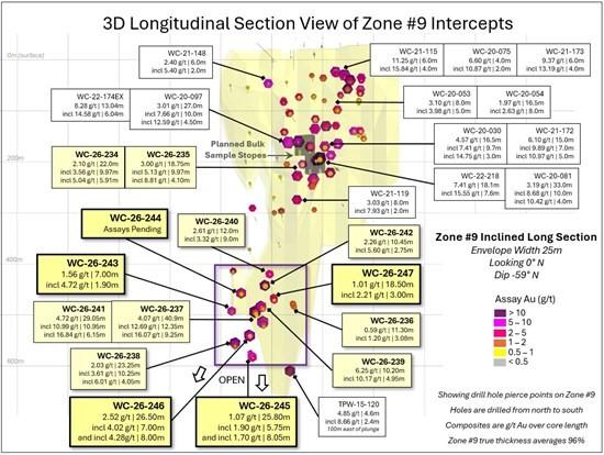
Figure 1 – Pierce Point View of WC-26-243 to WC-26-247 Intercepts
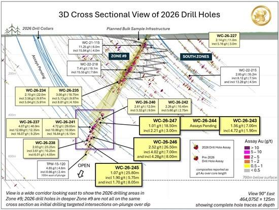
Figure 2 – 3D Cross Sectional View of WC-26-243 to WC-26-246 Intercepts and Bulk Sample Area
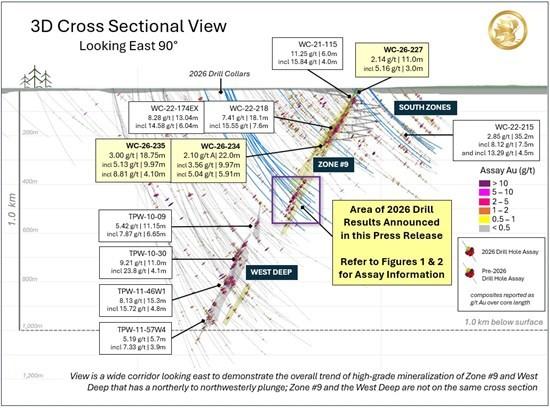
Figure 3 – 3D View of High-Grade Mineralization in Zone #9 and the West Deep
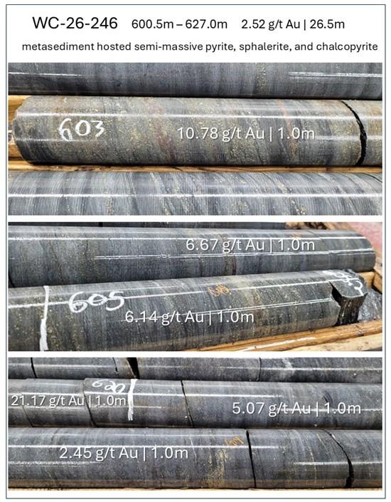
Figure 4 – Core Photos of Gold Mineralization in WC-26-246
Technical Content and Qualified Person
The technical content of this news release has been reviewed and approved by Leah Page, P.Geo., Vice President, Exploration and a Qualified Person (“QP”) as defined in National Instrument 43-101 – Standards of Disclosure for Mineral Projects.
Quality Assurance / Quality Control
Quality Control and Assurance procedures and protocols are executed to ensure sampling and analysis of all exploration work is conducted in accordance with best practices. Core produced at the West Cache Property is delivered to the Company’s Timmins logging facility by the drill contractor with all logging, cutting, labeling, and bagging completed under supervision of Qualified Geologists. NQ sized core is predominantly sawn in half with one half of the core prepared for shipment, while the other half is retained for future assay verification.
Core samples are transported from the Company’s Timmins logging facility to AGAT Laboratories in Thunder Bay, Ontario for both prep and 30g fire assay analysis. Results are reported in batches of 60-72 samples and average 4-5 QC samples per certificate. Commercially prepared certified reference material (CRM) and duplicate samples are inserted at an average rate of 6% to 8%. At least one blank, standard and duplicate (pulp or coarse) is inserted for every 50 samples and additional QC samples are inserted at the Geologist’s discretion. All samples reported have been checked against the Company’s internal, and the Lab’s, quality control samples.
About the West Cache Gold Project
The West Cache Gold Project is an advanced-stage gold exploration project covering approximately 11,600 ha located 13 km west of Timmins, Ontario on Provincial Highway 101. It is situated in the Western Porcupine Gold Camp along the Destor-Porcupine Fault Zone within the Abitibi greenstone belt, approximately 7 km northeast of Pan American Silver’s Timmins West Mine. The mining lease area hosts the current Mineral Resource Estimate near the center, with additional exploration targets to the north and south. The Mineral Resource Estimate is contained within the Porcupine Sedimentary Basin, a favourable litho-structural corridor with over 5 km of strike-length on the Property. Mineralization is open in all directions and at depth.
About Galleon Gold
Galleon Gold is advancing the West Cache Gold Project with a disciplined, de-risking strategy centered on resource growth and an upcoming 86,500-tonne bulk sample program, positioning the Company to unlock long-term shareholder value.
Premier American Uranium Inc. (TSX-V: PUR) (OTCQB: PAUIF) is plea... READ MORE
Highlights: Expansion diamond drilling is underway at Eloro Resou... READ MORE
Highlights BBM extended at depth, outside the current Mineral Res... READ MORE
Results include 9.72 g/t Au over 7.2 m in hole 26-SPX-RC135 and 9... READ MORE
TNR Gold Corp. (TSX-V: TNR) announces that it has received an uns... READ MORE


