


Fortune Bay Corp. (TSX-V: FOR) (FWB: 5QN) (OTCQX: FTBYF) is pleased to announce initial drill results for its 100% owned Strike Uranium Project located in northern Saskatchewan (see Figures 1 and 2). A total of nine drill holes were completed comprising 2,064 metres. Results included shallow intersections of elevated radioactivity, between 35 and 95 metres below surface, within favorable geological settings for high-grade, basement hosted deposits typical of the Athabasca Basin.
Highlights:
Dale Verran, CEO for Fortune Bay, commented, “We are very pleased with the initial results from the maiden exploration drilling program at the Strike Uranium Project. This was the first drill program aimed at testing the extensive electromagnetic conductors on the project at shallow depths, and the results have identified the key ingredients for high-grade, basement-hosted discoveries related to the Athabasca Basin. The intersection of elevated radioactivity and favorable alteration, associated with prospective graphitic structures, indicates the presence of a uranium mineralizing system adjacent to the present-day edge of the Athabasca Basin. Our experienced technical team is particularly encouraged by the results from drill hole S22-013 which was highlighted by 1,800 cps within a graphitic fault with hydrothermal alteration, representing a priority area for follow-up along the K-conductor. Laboratory uranium assay and geochemical results, combined with structural analysis of drill core and detailed surface mapping, will be utilized to plan a follow-up program.”
Mr. Verran further added, “Exploration drilling has now commenced at the Murmac Uranium Project where the Company plans to test a compelling set of eight to ten targets identified from electromagnetic and gravity surveying in proximity to numerous radioactive and uranium surface showings and/or favorable structural features. We are looking forward to the continued drilling results from our Strike and Murmac Uranium Projects.”
Strike Drill Results
Drill Program Summary
A total of nine drill holes (2,064 metres) were completed during the period May 21 to June 15, 2022. Holes were drilled to test the targets documented in the News Release dated April 26, 2022, which were refined following completion of ground gravity surveying in May. Two holes were drilled at the Tena target, a historical prospect where over 1,000 tonnes of uranium ore were mined in the 1950’s with reported grades of 0.6% to 3.5% U3O8. A third hole was drilled at the Tena South target, a coincident gravity low and electromagnetic conductor immediately south of the Tena prospect. The remaining six holes targeted discrete gravity lows located along prominent EM conductor corridors (named “J”, “K” and “L”) proximal to favourable geochemistry results and structural features. Drill hole collar information is summarized in Table 1 and drill hole locations are shown in Figure 3.
Table 1: Strike Drill Hole Summary.
| Hole ID | Target | Easting | Northing | Dip | Azimuth | Length (m) |
| S22-005 | Tena | 609135.1 | 6601530.4 | -50° | 342° | 152.0 |
| S22-006 | Tena | 609080.7 | 6601509.9 | -50° | 342° | 131.0 |
| S22-007 | Tena South | 608954.6 | 6601392.9 | -45° | 155° | 251.0 |
| S22-008 | L1 | 610086.2 | 6601679.4 | -45° | 315° | 173.0 |
| S22-009 | J3 | 608637.9 | 6605013.5 | -45° | 225° | 350.0 |
| S22-010 | K4 | 610188.5 | 6603465.7 | -45° | 100° | 284.0 |
| S22-011 | L4 | 611726.0 | 6605012.0 | -45° | 300° | 233.0 |
| S22-012 | J2 | 607786.3 | 6604938.2 | -45° | 145° | 230.0 |
| S22-013 | K3 | 609312.7 | 6602761.6 | -45° | 115° | 260.0 |
| Notes: Coordinates are reported in UTM NAD83 Zone 12N. Azimuth is true north. | ||||||
Initial Drill Results
The initial drill results for each drill hole are summarized below, with final drill results to be announced following receipt of uranium assay, geochemical and reflectance data. Radioactivity results are presented as minimum and maximum counts per second (“cps”) recorded within the interval reported, as measured by a Super-SPEC RS-125 handheld gamma-ray spectrometer. A summary of any elevated radioactivity (> 300 cps) encountered is provided in Table 2.
Table 2: Summary of elevated radioactivity intersected.
| Target | Hole ID | Radioactivity | Association |
| Tena | S22-005 | 365 cps from 82.1 to 84.1 m, including 1,300 cps from 82.3 to 82.4 m | Graphitic brittle fracture zone with hematization and chloritization – Tena Fault. |
| Tena | S22-006 | 390 cps from 106.9 to 107.5 m, including 500 cps from 107.0 to 107.1 m | Graphitic brittle fracture zone with hematization and chloritization – Tena Fault. |
| K4 | S22-010 | 300 cps from 53.8 to 53.9 m
330 cps from 55.0 to 55.1 m 340 cps from 135.1 to 135.4 m |
Shallow radioactivity hosted in graphitic faults.
Deeper radioactivity associated with graphitic |
| K3 | S22-013 | 840 cps from 145.5 to 145.8 m, including 1,800 cps from 145.7 to 145.8 m | Reactivated graphitic fault with disseminated to vein-hosted occurrence associated with weak to moderate hydrothermal alteration. |
| Notes: Radioactivity measurement (“cps”) is taken using a Super-SPEC RS-125 handheld gamma-ray spectrometer. The cps values are averages for the reported drill interval. The Company considers values > 300 cps to be elevated for the Project. | |||
Technical Disclosure
All drilling is being carried out with NQ3 or NQ2 diameter. Radioactivity in counts per second (“cps”) has been measured using a Super-SPEC RS-125 Spectrometer. Individual measurements are taken over 0.1 metre core increments, which is the approximate width of the instrument sensor, and averaged over larger intervals where elevated. Core is removed from the core box and moved, if necessary, to a location where the instrument reads below background, and the measurement is collected by placing the sensor against the core at the required location. Background radioactivity is estimated at 200 cps, and values > 300 cps are considered to be elevated. The oriented drill cores are being subjected to comprehensive logging and sampling to characterize mineralization, alteration and structure. Samples will be submitted to the Saskatchewan Research Council (“SRC”) Geoanalytical Laboratories (ISO/IEC 17025:2005 accredited) for uranium assay and multi-element characterization.
Unless otherwise stated, the historical results (including drill results) contained within this news release have not been verified and there is a risk that any future confirmation work and exploration may produce results that substantially differ from the historical results. The Company considers these results relevant to assess the mineralization and economic potential of the property. Further details regarding the historical Tena prospect can be found within the Saskatchewan Mineral Deposit Index (SMDA #1511). Further details regarding the historical surface grab samples from HY080, Stancliff and Hacker Atompower are available within Cameco Corp. assessment reports filed on the Saskatchewan Mineral Assessment Database (SMAD File Number 74N-0102, 74N-0103 and 74N-0106).
Qualified Person and Data Quality
The technical and scientific information in this news release has been reviewed and approved by Dale Verran, M.Sc., P.Geo., Chief Executive Officer of the Company, who is a Qualified Person as defined by NI 43-101. Mr. Verran is an employee of Fortune Bay and is not independent of the Company under NI 43-101.
About Fortune Bay
Fortune Bay Corp. is an exploration and development company with 100% ownership in two advanced gold exploration projects in Canada, Saskatchewan (Goldfields Project) and Mexico, Chiapas (Ixhuatán Project), both with exploration and development potential. The Company is also advancing the 100% owned Strike and Murmac uranium exploration projects, located near the Goldfields Project, which have high-grade potential typical of the Athabasca Basin. The Company has a goal of building a mid-tier exploration and development Company through the advancement of its existing projects and the strategic acquisition of new projects to create a pipeline of growth opportunities. The Company’s corporate strategy is driven by a Board and Management team with a proven track record of discovery, project development and value creation.
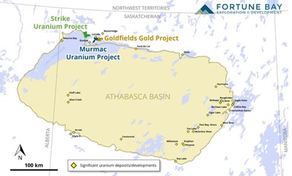
Figure 1: Location of the Goldfields, Strike and Murmac Projects relative to the Athabasca Basin. (CNW Group/Fortune Bay Corp.)
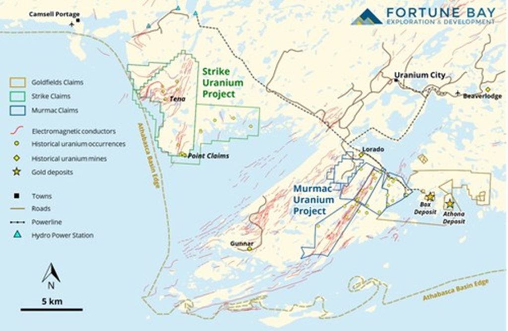
Figure 2: Location of the Goldfields, Strike and Murmac Projects. (CNW Group/Fortune Bay Corp.)
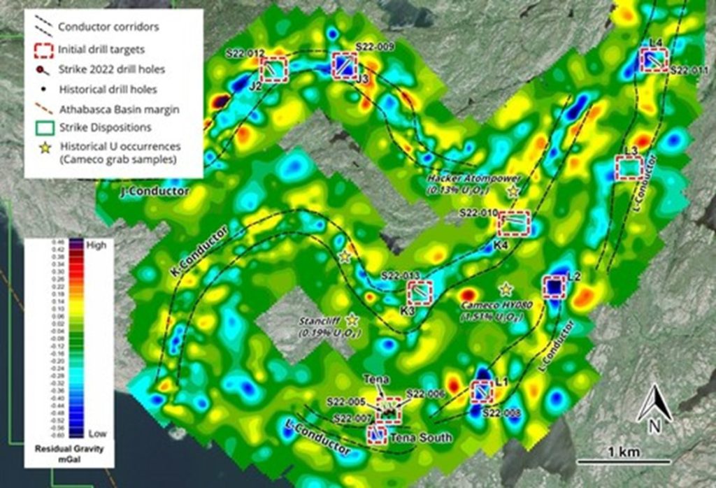
Figure 3: Location of the nine drill holes completed on the Strike Uranium Project. (CNW Group/Fortune Bay Corp.)
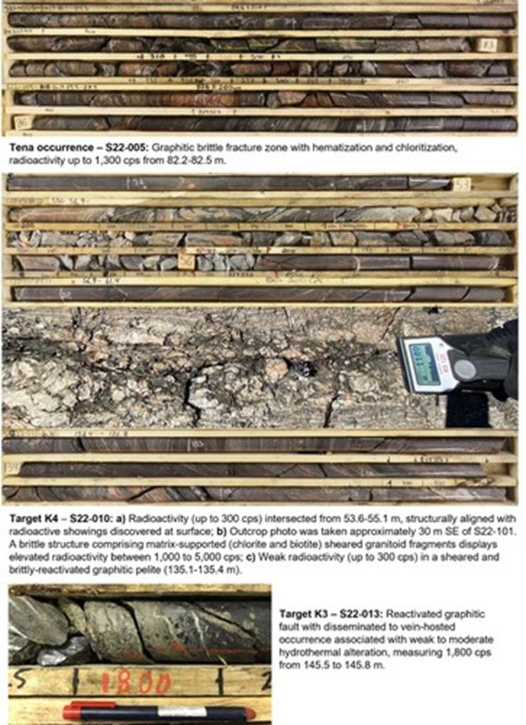
Figure 4. Drill core and outcrop photographs from Strike Uranium Project. (CNW Group/Fortune Bay Corp.)
Hudbay Minerals Inc. (TSX:HBM) (NYSE: HBM) today released its ann... READ MORE
Strategic acquisition of an established operating gold mine, loca... READ MORE
Cerro de Pasco Resources Inc. (TSX-V: CDPR) (OTCQB: GPPRF) (FRA: ... READ MORE
The Garneau Titanium Project Features Ilmenite-Rich Boulder with ... READ MORE
ValOre Metals Corp. (TSX‐V: VO) (OTCQB: KVLQF) (Frankfurt: KEQ0... READ MORE


