








The Prospector News

Filo Mining Reports 701m at 1.13% CuEq; Extends the Aurora Zone Strike Length to 1.6km

You have opened a direct link to the current edition PDF

Open PDF Close
Uncategorized

Share this news article

Filo Mining Reports 701m at 1.13% CuEq; Extends the Aurora Zone Strike Length to 1.6km


Filo Mining Corp. (TSX: FIL) (Nasdaq First North Growth Market: FIL) (OTCQX: FLMMF)  is excited to announce results from two holes at the Filo del Sol Project in San Juan, Argentina. Drillholes FSDH061 and FSDH063 have successfully extended the strike length of the Aurora Zone by 180m to a total of 1.6km, and it remains open to expansion in the north and south directions. Highlights and detailed results are shown below:


Drillhole FSDH061 intersected 701.2m at 1.13% CuEq from a depth of 392m, including;

    • 406m at 1.36% CuEq from 508m
    • The hole ended in strong mineralization at a depth of 1,093m
  • Drillhole FSDH063, located 1.6km southwest of FSDH061, was drilled to a final depth of 1,141m and intersected 844.2m at 0.53% CuEq from a depth of 16m, including;
    • 142m at 0.71% CuEq from a depth of 16m and,
    • 112m at 0.86% CuEq from a depth of 436m
  • The Aurora Zone is interpreted to be continuous between these two holes, with large undrilled gaps remaining, and is open to the south of FSDH063 and to the north of FSDH061.


Commenting on the results, Jamie Beck, President, and CEO stated, “Hole 61 pulls the Aurora Zone another 180m northeast of Hole 57, which was our previous northernmost intersection in this zone of elevated grade. The Aurora Zone is completely open to the north beyond this hole, and now extends 1.6 km southwest to the intersection in Hole 63. As we ramp up drilling into the South American spring and summer, we will continue a combination of larger step-out holes to try to find the edges of the mineralized system, along with step-out and infill holes to try to fully define the size of this remarkable Aurora Zone.”


Hole ID From To Length (m) Cu % Au g/t Ag g/t CuEq %
FSDH061 392.0 1,093.2 701.2 0.81 0.33 9.1 1.13
incl 508.0 914.0 406.0 0.97 0.40 11.1 1.36
FSDH063 16.0 860.2 844.2 0.29 0.25 6.5 0.53
incl 16.0 548.0 532.0 0.35 0.32 9.0 0.66
incl 16.0 158.0 142.0 0.36 0.26 18.1 0.71
incl 436.0 548.0 112.0 0.42 0.42 15.0 0.86


FSDH061 was collared 230m to the northeast of FSDH057 and drilled to the west at an angle of -70o to a final depth of 1,093m where it was unable to continue due to technical problems. The hole cut the typical sequence of fragmental and coherent rhyolite country rock to a depth of 522m where it intersected the main mineralized breccia. The breccia is dominated by rhyolite clasts to a depth of 1,025m where it transitions to a granite-dominated breccia. The hole ended in well mineralized, potassic altered, homogeneous granite and granite breccia cut by moderately abundant A veins. The last 21m returned 1.03% CuEq (0.73% Cu, 0.38g/t Au, 2.8g/t Ag). Sparse, narrow, late-mineral porphyry dykes cut the sequence throughout, and scattered clasts of porphyry are common within the breccia.


This hole clearly extends the Aurora Zone and confirms its generally NNE strike direction. There are no holes drilled along this trend to the NNE between FSDH061 and FSDH060 which intersected the Bonita Zone, another 1.6km away (see News Release dated June 9, 2022). Three deep holes were drilled to the west of the Aurora trend in the 2020/2021 season, all of which intersected mineralization consistent with the edge of the zone, suggesting that it should continue several hundred metres beyond FSDH061. These holes include FSDH037, 100m north of FDSH061 (502m @ 0.75% CuEq; 0.41% Cu, 0.13g/t Au, 27.8g/t Ag); FSDH043, 400m north of FSDH061 (294m @ 0.61% CuEq; 0.47% Cu, 0.16g/t Au, 2.6g/t Ag) and FSDH051, 1,200m north of FSHD061 (344m @ 0.50% CuEq; 0.26% Cu, 0.21g/t Au, 9.4g/t Ag). Details of these holes can be found in news releases dated May 13, 2021; March 31, 2021 and August 4, 2021 respectively.


FSDH063 is located 1.6km SSW of FSDH061 along the Aurora trend.  It was collared 140m to the west of FSDH025 and drilled towards the west at -70o. FSDH025, completed in 2019, was the first hole drilled deeper than 1,000m at Filo del Sol, and returned 1,025m @ 0.47% CuEq (0.30% Cu, 0.22g/t Au, 1.6g/t Ag). As additional drilling outlined the NNE trend of the Aurora Zone, this hole was interpreted to have been drilled to the east of the trend and FSDH063 was planned to test for the southern extension of the zone west of FSDH025.

FSDH063 intersected the resource block model down to a depth of 436m, with grades as predicted. The interval from 436m to 548m is interpreted as the Aurora Zone in this hole, ending at the contact with an intermineral porphyry which continues to 649m. The mineralized breccia continues below this, however, grades are diminished from the main interval and alteration is predominantly phyllic rather than silica and quartz-alunite as is seen further north.  Granite and associate breccias are intersected from 907m to the end of the hole.


The Aurora Zone remains open to the south of this hole, and large distances remain to the north and down-dip for expansion. Down dip, FSDH025 is just over 500m away from FSDH063 (it was drilled steeper than FSDH063 so the two holes diverge with depth), and to the north there is an undrilled gap of 590m between FSDH063 and FSDH048 (1,081m @ 0.88% CuEq; 0.52% Cu, 0.43g/t Au, 5.3g/t Ag).


Outlook


Drilling was interrupted by an unusually harsh winter in the Andes, with uncharacteristically large snowfalls and strong winds occurring through several storms since late June. As always, we prioritize the safety of our personnel while maintaining operations. The weather has now improved, and drilling is currently underway with six diamond rigs on site, and six holes in progress. As the weather continues to moderate into spring and summer, we will be adding two brand new, state-of-the-art diamond rigs into the program in September which will allow us to drill even deeper at Filo del Sol. Our year-round operations planning sees the company drilling with up to 11 rigs, and this plan would see approximately 40,000m of drilling completed over the next 12 months.


Holes that have been completed with assays pending include:

  • FSDH066, located 1.3km northeast of FSDH060, to investigate a shallow target under the Maranceles veins (a series of quartz-enargite veins which outcrop in this area), was completed to a depth of 458m


Holes underway, with current depths, include:

  • FSDH062 (1,089m) Infill between holes 44 and 46 – a 200m gap
  • FSDH064 (825m) Infill between holes 48 and 32 – a 400m gap
  • FSDH065 (196m) Suspended for winter, will resume in spring
  • FSDH067 (1,145m) Infill between holes 48 and 32 – a 400m gap
  • FSDH068 (124m) A 150m step-out east of FSDH054
  • FSDH069 (134m) A short step-out to explore the bottom of the FSDH057 intersection
  • FSDH070 (38m) A step-out west (up-dip) of FSDH041


Assay results for these holes will be released as they are received, analyzed and confirmed by the Company.


About Filo del Sol


Filo del Sol is a high-sulphidation epithermal copper-gold-silver deposit associated with one or more large porphyry copper-gold systems. Overlapping mineralizing events combined with weathering effects, including supergene enrichment, have created several different styles of mineralization, including structurally controlled and breccia-hosted gold, manto-style high-grade silver (+/- copper) and high-grade supergene enriched copper within a broader envelope of disseminated, stockwork and breccia-hosted sulphide copper and gold mineralization. This complex geological history has created a heterogeneous orebody which is characterized by zones of very high-grade copper +/- gold +/- silver mineralization within a large envelope of more homogeneous, lower-grade mineralization.


Qualified Persons and Technical Notes


The scientific and technical disclosure for the Filo del Sol Project included in this news release have been reviewed and approved by Bob Carmichael, B.A.Sc., P.Eng. who is the Qualified Person as defined by NI 43-101. Mr. Carmichael is Vice President, Exploration for the Company. Samples were cut at Filo Mining’s operations base near the town of Guañizuil, Argentina by Company personnel. Diamond drill core was sampled in 2 metre intervals (except where shortened by geological contacts) using a rock saw for sulphide mineralization. Oxide mineralization was cut with a core splitter in order to prevent dissolution of water-soluble copper minerals during the wet sawing process. Core diameter is a mix of PQ, HQ and NQ depending on the depth of the drill hole. Samples were bagged and tagged and packaged for shipment by truck to the ALS preparation laboratory in Mendoza, Argentina where they were crushed and a 500g split was pulverized to 85% passing 200 mesh. The prepared samples were sent to the ALS assay laboratories in either Lima, Peru or Santiago, Chile for copper, gold and silver assays, and multi-element ICP and sequential copper analyses. ALS is an accredited laboratory which is independent of the Company. Gold assays were by fire assay fusion with AAS finish on a 30g sample. Copper and silver were assayed by atomic absorption following a 4 acid digestion. Samples were also analyzed for a suite of 36 elements with ICP-ES and a sequential copper leach analysis was completed on each sample with copper greater than 500ppm (0.05%). Copper and gold standards as well as blanks and duplicates (field, preparation and analysis) were randomly inserted into the sampling sequence for Quality Control. On average, 9% of the submitted samples are Quality Control samples. No data quality problems were indicated by the QA/QC program.


Mineralized zones within the Filo del Sol deposit are typically flat-lying, or bulk porphyry-style zones and drilled widths are interpreted to be very close to true widths.


1Copper Equivalent (CuEq) for drill intersections is calculated based on US$ 3.00/lb Cu, US$ 1,500/oz Au and US$ 18/oz Ag, with 80% metallurgical recoveries assumed for all metals. The formula is:  CuEq % = Cu % + (0.7292 * Au g/t) + (0.0088 * Ag g/t).


About Filo Mining


Filo Mining is a Canadian exploration and development company focused on advancing its 100% owned Filo del Sol copper-gold-silver deposit located in Chile’s Region III and adjacent San Juan Province, Argentina. Filo Mining is a member of the Lundin Group of Companies.
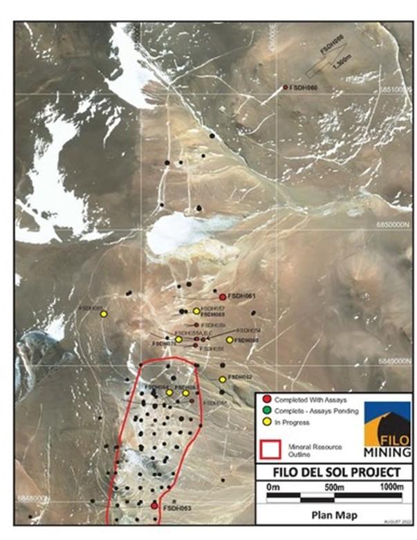


Filo Mining Plan Map – August 23, 2022 (CNW Group/Filo Mining Corp.)
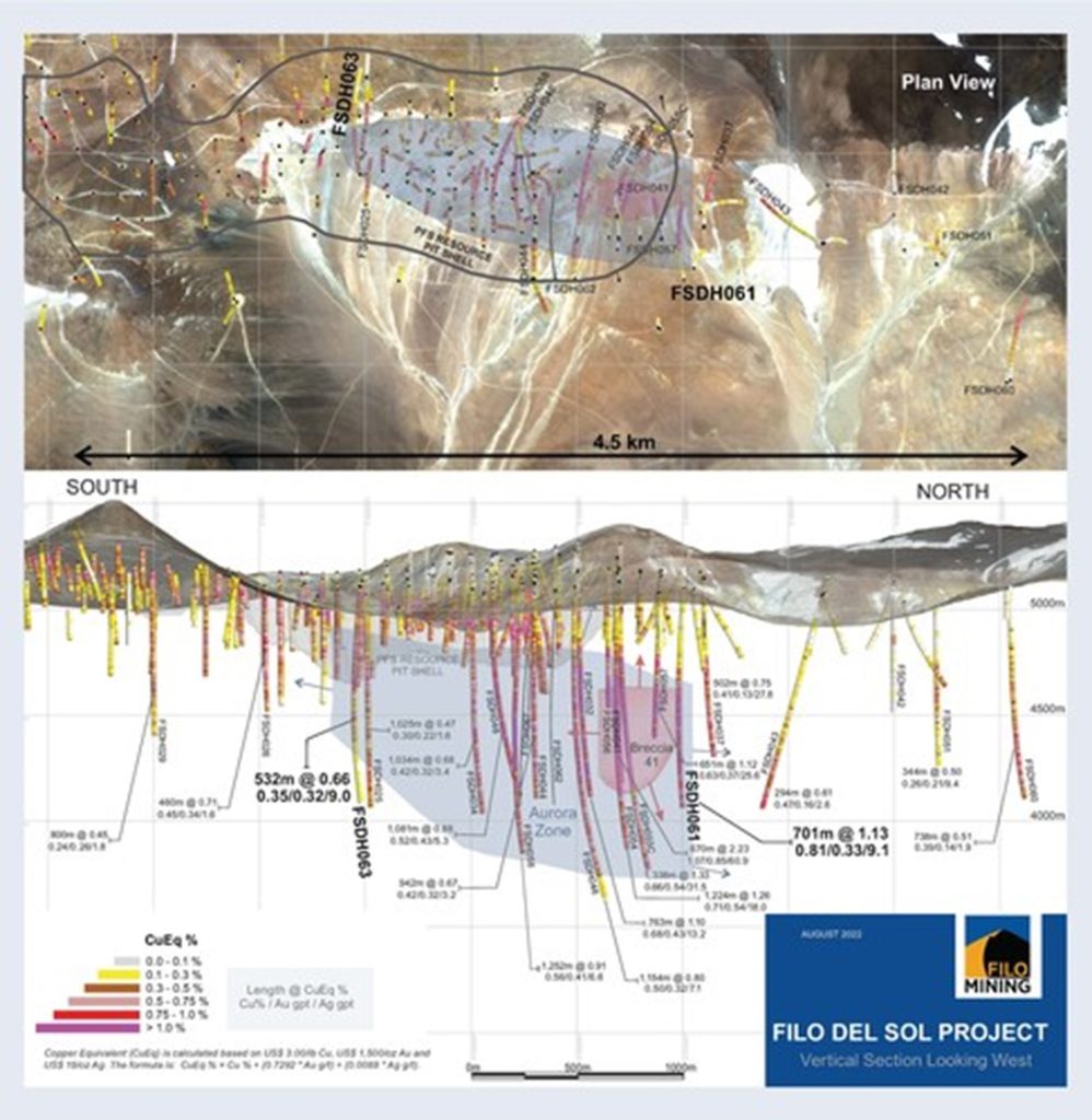


Filo Mining Long Section Plan Map – August 23, 2022 (CNW Group/Filo Mining Corp.)


Posted August 24, 2022

Share this news article

MORE or "UNCATEGORIZED"


Critical Metals Corp Achieves Breakthrough Tanbreez Heavy Rare Earth Results: >99% Dissolution of Eudialyte Concentrate Into 19 Ultra-High-Purity Rare Earth Products; Refinery Study Projects US$1.8–2.2b in Annual Refinery Revenue

Critical Metals Corp. (Nasdaq: CRML) a leading critical minerals ... READ MORE

September 16, 2026

Metalsource Mining Extends High Grade Mineralization at Depth as Silver Hill Exploration Enters Major Expansion Phase

Holes SH26-22 and SH26-23 return up to 930 g/t AgEq within broade... READ MORE

September 16, 2026

Pasinex Completes Sale of High-Grade Zinc Sulphide Material and Provides Pinargozu Operations Update

Pasinex Resources Limited (CSE: PSE) (FSE: PNX) a growing zinc-fo... READ MORE

September 16, 2026

Aya Gold & Silver Reports High-Grade Silver Exploration Results Near Pit and at Depth at Zgounder

Aya Gold & Silver Inc. (TSX: AYA; NASDAQ: AYA) is pleased to... READ MORE

September 16, 2026

New Break Resources Ltd. (CSE: NBRK) (OTCQB: NBRKF) (FSE: O91) has received results from the last four holes of a ten-hole, 1,996 metre summer drilling program in the Zavitz gold zone at the Company's 100% owned Moray gold project. In total, New Break has completed 5,372 metres of drilling in 32 drillholes in 2026. Moray is located 49 km southeast of Timmins, Ontario and 32 km northwest of the Young-Davidson gold mine operated by Alamos Gold Inc. Select results from the final four of ten holes drilled in the summer drilling program are presented below in Table 1, while drillhole collar locations are detailed in Table 2 in Appendix A. Table 1 – Moray Summer 2026 Final Drill Results Hole ID Length (m) From (m) To (m) Width (1) (m) Au Grade (2) (g/t) NBR-26-29 322.0 77.3 78.8 1.5 0.42 and 138.0 139.1 1.1 0.38 and 162.5 173.3 10.8 (3) 1.61 and 227.4 229.0 1.6 1.21 and 231.5 232.1 0.6 1.72 NBR-26-30 250.0 37.0 38.0 1.0 0.30 and 102.8 103.5 0.7 0.60 and 121.5 122.5 1.0 0.36 and 124.5 125.5 1.0 0.33 and 128.5 129.0 0.5 0.90 and 131.0 132.0 1.0 0.36 and 169.8 174.0 4.2 2.65 and 178.0 179.5 1.5 0.77 and 183.5 186.6 3.1 1.22 and 190.0 190.5 0.5 1.06 and 191.5 192.5 1.0 1.48 and 196.0 200.5 4.5 2.53 and 203.5 204.0 0.5 2.15 and 206.5 212.0 5.5 1.57 NBR-26-31 274.0 169.0 170.5 1.5 0.37 and 184.5 186.0 1.5 0.51 and 197.0 200.0 3.0 0.94 and 201.5 202.0 0.5 0.50 and 203.5 210.0 6.5 (3) 3.12 NBR-26-32 352.0 73.5 74.0 0.5 0.44 and 174.0 174.6 0.6 0.52 and 194.0 195.0 1.0 0.66 and 199.8 203.3 3.5 2.29 and 227.3 228.0 0.7 0.97 (1) Intervals are drill intersections and do not necessarily represent true widths. (2) All intervals are presented using a cut-off grade of 0.3 g/t Au and internal dilution of no more than 1.0 metres at grades less than 0.3 g/t Au and assays are not capped (see QA/QC Procedures). (3) Drill core photos shown in Appendix B. Figure 1 – Newly Reported Drillholes NBR-26-29, 30 Figure 2 – Newly Reported Drillholes NBR-26-30, 31, 32 Note: The bottom of NBR-26-30 deviated southeast and is represented in both sections. Figure 1: Section B-B1 incorporates drillholes NBR-26-06, 07, 08, 25, 26, 27, 28, 29 and part of 30. Gold mineralization extends southeast into the syenite as exhibited in NBR-26-29. NBR-26-30 is identified in both sections A-A1 and B-B1 as the drillhole was collared along section A-A1 but deviated southeast, intersecting gold mineralization in the mafic volcanics in section B-B1. Figure 2: A-A1 incorporates drillholes NBR-26-03, 04, 05, 23, 24, 30, 31 and 32. NBR-26-31 exhibits gold mineralization both within the syenite (at the contact) and within a "flow breccia" within the hematite altered mafic volcanic at the contact. NBR-26-32 is typified by blocky faulted ground with lamprophyre dykes and gold mineralization in the hematite altered mafic volcanics in a brecciated quartz vein with angular syenitic fragments. William Love, Chief Executive Officer of New Break commented, "Ongoing drilling this summer in the Zavitz gold zone continues to deliver significant gold values, with gold mineralization intercepted in every drillhole. As depicted in Figures 1 and 2, gold mineralization has been encountered predominantly within the mafic volcanics. Importantly, drillholes NR-26-29 and NR-26-32, the deepest drilled to date, demonstrate that gold mineralization extends into the syenite to the southeast at the contact with the mafic volcanics." He further noted, "The intrusive-mafic volcanic contact in the Zavitz gold zone has a distinctive magnetic high. This could be reflective of the higher proportion of iron in these mafic volcanics, which is associated with the higher gold values. This same magnetic and IP signature has been identified elsewhere in areas also believed to be along the intrusive-mafic volcanic contact. Drilling these never before tested targets with the goal of identifying gold mineralization similar to that encountered in the Zavitz zone represents the potential for significantly expanding the Moray gold discovery. There is also the belief that the Zavitz zone could represent the first of a series of stacked mineralized gold zones, which would point to the potential for a much larger gold system at depth. We plan to test this through deeper drilling directly into the Zavitz zone." About the Moray Gold Project The Moray property is located in the heart of the Ontario Abitibi greenstone belt, 49 km southeast of Timmins surrounded by a number of significant gold producing companies and existing mills (see Figure 3). The Young-Davidson gold mine operated by Alamos Gold Inc., with its 8,000 tonne per day mill is the closest and within a short trucking distance of approximately 45 km by road from Moray. The understanding of gold mineralization at Moray continues to evolve with each round of drilling. The occurrence of gold mineralization extending into the syenite to the southeast of the Zavitz zone and in the deepest drillholes is noteworthy given the presence of syenite-hosted mineralization at Young-Davidison. More recent examination of the drill core also suggests that the gold mineralization discovered to date may resemble an intrusion related style of deposit like Agnico Eagle's Upper Beaver gold deposit east of Kirkland Lake, as opposed to a structurally hosted gold system. Both Young-Davidson and Upper Beaver host multi-million ounce gold deposits. Figure 3 – Moray Location Map: Surrounding Gold Producers and Upper Beaver Gold Project Technical Content and Qualified Person The scientific and technical information contained in this news release has been reviewed and approved by Peter C. Hubacheck, P. Geo, consulting geologist to New Break, and an independent Qualified Person as defined by National Instrument 43-101. Mr. Hubacheck certifies that this news release fairly and accurately reflects the technical information and data presented. New Break conducts its exploration activities in accordance with CIM Best Practices Guidelines. QA/QC Procedures QA/QC procedures were executed to ensure all work is conducted in accordance with best practices. All drill core was sawn in half with one half of the core prepared for shipment and the other half retained for future verification. All core is under watch from the drill site to the core processing facility. Drill core is BQTK size and sample intervals range from 0.5 metres to 1.0 metres in length. Commercially prepared certified reference material ("CRM") standards and blanks were inserted with each shipment at a rate of 1 QAQC sample in every 12 core samples. Samples from New Break's 2026 Moray drilling program were analyzed at Activation Laboratories in Timmins, Ontario, which is ISO 17025 certified, by 30-gram fire assay with atomic absorption finish. Any sample assaying greater than 10.0 g/t Au was re-assayed with fire assay gravimetric analysis. Grade composite intervals over core lengths are calculated using a weighted average grade with a cut-off grade of 0.3 g/t Au. Up to 1.0 m of internal dilution (consecutive interval below cut-off grade) are included within specific geologic domains and alteration assemblages, except as otherwise noted. The composites are constrained geologically by metasomatic alteration processes sourcing from the Fiset syenite intrusion and contact mafic volcanic rocks. Elevated gold values are coincident with hematite, silica, sericite and pyrite mineralization within structurally prepared brecciated corridors flanking the intrusion. Intervals are not true widths and no top cutting has been applied to the higher gold values. About New Break Resources Ltd. New Break is a Canadian mineral exploration company focused on its Moray gold project located 49 km southeast of Timmins, Ontario, in a well-established mining camp within proximity to existing infrastructure, and 32 km northwest of the Young-Davidson gold mine, operated by Alamos Gold Inc. Shareholders are also leveraged to exploration success in Nunavut, Canada, through New Break's 20% carried interest in the Sundog gold project and ownership of 6.0 million shares of Guardian Exploration Inc. (TSXV: GX). The Company is supported by a highly experienced team of mining professionals. Appendix A – Drillhole Data and Locations Table 2 – Moray Summer 2026 Drillhole Collar Locations Hole ID Length (m) UTM Easting UTM Northing UTM Elevation Azimuth (degrees) Dip (degrees) NBR-26-29 322.0 492703 5320285 363 220 -70 NBR-26-30 250.0 492708 5320329 363 220 -47 NBR-26-31 274.0 492708 5320329 363 220 -60 NBR-26-32 352.0 492708 5320329 363 220 -70 Total 1,198.0 Coordinates are reported in UTM Zone 17 North, with units in metres. Figure 4 – Zavitz Gold Zone – Surface Traces of 2025 and 2026 Drillholes. All of the drilling at Moray has been completed by Enviro North Exploration Inc. out of Sturgeon Falls, Ontario. Drilling in the Zavitz gold zone is shown in figure 4, with the 1,996 metres in 10 holes drilled this summer depicted in red, the 2,807 metres in 20 holes drilled from January to April 2026 shown in blue and the 1,817 metres in 8 holes drilled in 2025 shown in black. In total, 6,620 metres in 38 drillholes have been completed in the Zavitz gold zone, while New Break has completed a total of 5,372 metres in 32 drillholes of our planned 2026, 10,000 metre drilling program. Appendix B – Drill Core Photos From NBR-26-29 and NBR-26-31

New Break Resources Ltd. (CSE: NBRK) (OTCQB: NBRKF) (FSE: O91) ha... READ MORE

September 16, 2026

Copyright 2026 The Prospector News
