


Entrée Resources Ltd. (TSX:ETG) (OTCQB:ERLFF) provides an update on matters related to the Entrée/Oyu Tolgoi joint venture mining licenses as well as drill and regional exploration results received from the Company’s joint venture partner Oyu Tolgoi LLC.
ENTRÉE/OYU TOLGOI JV LICENSES UPDATE
The Company continues to focus its efforts on the transfer of the Shivee Tolgoi and Javkhlant mining licenses from the Company’s Mongolian subsidiary Entrée LLC to OT LLC. Transfer of the JV Licenses is necessary to enable Lift 1 Panel 1 underground development work on the Shivee Tolgoi mining license area to p roceed.
On March 25, 2026, the Company delivered a non-binding proposal to the Minister of Industry and Mineral Resources of Mongolia as head of the Government Working Group established to negotiate the State’s interest in the area of the JV Licenses. The proposal contemplates, among other things, the transfer of the JV Licenses to OT LLC as required under the Oyu Tolgoi Investment Agreement and the Entrée/Oyu Tolgoi JV Agreement and payment of a negotiated royalty on the gross sales value of the Company’s concentrate as contemplated under the Minerals Law of Mongolia in lieu of the State being a 34% equity participant. The proposal is intended to form the basis for further discussions and negotiations with the Government of Mongolia.
On March 31, 2026, following the resignation of Prime Minister Zandanshatar, N. Uchral was sworn in as the 35th Prime Minster of Mongolia. On April 3, 2026, Prime Minister Uchral introduced his new cabinet, reappointing G. Damdinnyam as the Minister of Industry and Mineral Resources. The Company will continue to monitor the situation, including any potential changes to the Government Working Group, and provide further updates as considered necessary.
Entrée remains committed to working with the Government of Mongolia, Rio Tinto, and OT LLC in accordance with applicable laws of Mongolia to unlock the Oyu Tolgoi project’s full potential for the benefit of all parties.
DRILL AND REGIONAL EXPLORATION RESULTS
The Company is pleased to provi de analytical results for one surface diamond drill hole and 4 underground DDHs, which were part of the 2024 and 2025 in-fill drilling programs at the Hugo North Extension deposit on the Entrée/Oyu Tolgoi joint venture property in Mongolia. Regional exploration results are also provided, including analytical results for nine DDHs from the 2025 regional drilling campaign testing several targets on the Shivee Tolgoi and Javkhlant mining licences. All work was completed by the Company’s joint venture partner OT LLC, with expenditures borne by OT LLC and Entrée in proportion to their participating interests in the Entrée/Oyu Tolgoi JV.
DRILL HOLE HIGHLIGHTS
Significant HNE Underground Drill Holes
Significant Regional Exploration Drill Holes (Ulaan Khud Target)
Note: CuEq for HNE is defined in Note 3 to Tables 1 and 2 below, where details on the drill hole assay intervals are al so found.
HNE DRILLING RESULTS
The new drill hole analytical results received from OT LLC include one underground DDH from the 2024 drilling program and one surface DDH and 3 underground DDHs from the 2025 drilling program on the HNE deposit. The surface DDH was collared on the Entrée/Oyu Tolgoi JV Property, and the underground DDHs were all collared from existing infrastructure on the Oyu Tolgoi mining licence (100% OT LLC) and drilled towards the northwest or northeast onto the Entrée/Oyu Tolgoi JV Property. The DDHs targeted mineralization within or surrounding the existing footprint of the HNE deposit (Figure 1) in the proposed Lift 2 block cave. Details about the 2024 drilling program, including DDH locations, were previously disclosed by Entrée on February 27, 2025 (see the news release titled, “Entrée Announces Drill Results From Hugo North Extension and Heruga Deposits”).
Analytical results from the surface and underground DDH data provided by OT LLC are summarized in Table 1 and Table 2, respectively, and are shown on Figure 1.
Collar and drilling information for 5 DDHs which were part of the 2024 drilling program but completed in 2025 (3 surface drill holes and 2 underground drill holes), as well as details for 28 DDHs from the approved 2025 drilling program (6 surface drill holes and 22 underground drill holes) are provided in Table 3 and Table 4 below.
Analytical results for 3 surface DDHs and 4 under ground DDHs from the 2024 drilling program and 19 underground DDHs from the 2025 drilling program at HNE are still pending. These results will be reported as they become available from OT LLC.
Table 1: Surface Drill Results from the 2025 Drilling Program at the HNE Deposit1
| Drill Hole | Year | From (m) |
To (m) |
Length2 (m) |
Copper (%) |
Gold (ppm) |
Silver (ppm) |
CuEq3 (%) |
| EGD191 | 2025 | No | significant | results |
Note: EGD191 was terminated prior to reaching the HNE grade shell.
Table 2: Underground Drill Results from the 2024 and 2025 Drilling Programs at the HNE Deposit1
| Drill Hole | Year | From (m) |
To (m) |
Length2 (m) |
Copper (%) |
Gold (ppm) |
Silver (ppm) |
CuEq3 (%) |
| UGD927B | 2024 | 334 | 348 | 14 | 0.48 | 0.05 | 0.82 | 0.51 |
| and | 370 | 563.3 | 193.3 | 0.42 | 0.04 | 0.88 | 0.45 | |
| UGD951 | 2025 | 218 | 342 | 124 | 2.91 | 0.84 | 7.35 | 3.41 |
| including | 218 | 280 | 62 | 3.77 | 0.98 | 9.17 | 4.36 | |
| UGD952A | 2025 | 220 | 262.4 | 42.4 | 1.15 | 0.28 | 2.96 | 1.32 |
| UGD987 | 2025 | No | significant | results |
Notes for Tables 1 and 2:
Figure 1: Plan View of Newly Released Assay Intervals and Locations of 2022-2025 Drill Holes
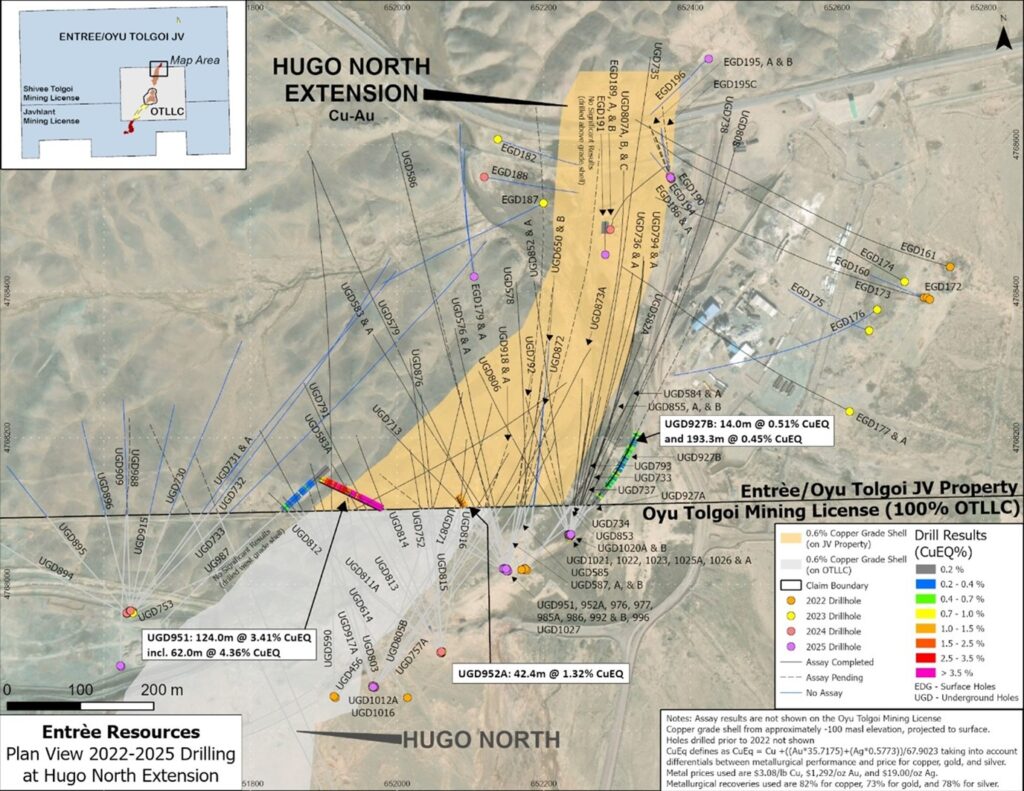
Surface drill hole EGD191 was collared above t he centre of the surface projection of the HNE mineralized footprint and drilled very steeply towards the north. After crossing through approximately 1,078 metres of barren granodiorite, sedimentary and volcanic units, the final 29 metres intersected weakly mineralized volcanics averaging 0.23% copper, near the top of the porphyry deposit, at which point the DDH was terminated.
Underground DDH UGD927B was drilled at a moderate dip towards the northeast, parallel to the trend of the porphyry deposit. The DDH remained in low grade copper mineralization east of the main mineralized porphyry and was drilled primarily for geotechnical purposes.
Underground DDH UGD951 was collared on the Oyu Tolgoi mining licence and drilled at a gentle dip towards the west-northwest. After crossing onto the Entrée/Oyu Tolgoi JV Property at 218 metres it immediately entered into the western portion of the HNE deposit in heavily phyllic and potassic altered quartz monzodiorite, cut by occasional intervals of unmineralized biotite-granodiorite dikes (generally less than 10 metres in drilled width). The quartz monzodiorite is mineralized with significant amounts of chalcopyrite and bornite, along with minor pyrite and returned high grades of copper and gold as shown in Table 2. The last 7 metres of the drill hole crossed into the footwall of the deposit where copper and gold grades drop off significantly.
Underground DDH UGD952A was collared from the same drill pad as UGD951 but drilled at a moderate dip towards the northwest. The drill hole crossed through phyllic altered quartz monzodiorite cut by occasional biotite-granodiorite dikes, and is mineralized with moderate amounts of chalcopyrite, bornite and pyrite. The drill hole returned significant values of copper and gold as shown in Table 2 and was terminated in strong mineralization at a depth of 262.4 metres.
The final underground drill hole with analytical results is UGD987, which was collared from an underground drill pad on the Oyu Tolgoi mining licence, west of the HNE deposit. The drill hole was drilled northeast at a moderate dip, remaining parallel to, and west of the edge of the HNE deposit and was designed primarily for geotechnical purposes. The drill hole crossed a mix of lightly potassic and feldspar altered quartz monzodiorite, biotite-granodiorite and hornblende-biotite granodiorite. Analytical results between 480 and 558 metres were anomalous, averaging 0.30% CuEq over 78 metres. Beyond this the analytical results are insignificant to the end of the hole at 600 metres.
Table 3: HNE Surface Drill Hole Collar Details
| Drill Hole | UTM East1 |
UTM North1 |
Elevation (masl) |
Length (m) |
Azimuth (degrees) |
Dip (degrees) |
Assay Status |
| EGD179 | 652105 | 4768420 | 1197 | 1689.8 | 353 | -86.8 | Not assayed |
| EGD179A | 652105 | 4768420 | 1197 | 343.8 | 351 | -86.4 | Not assayed |
| EGD186 | 652373 | 4768555 | 1175.384 | 1012.4 | 352 | -86.5 | Not assayed |
| EGD186A | 652373 | 4768555 | 1175.384 | 160.5 | 347 | -86.2 | Not assayed |
| EGD191 | 652284 | 4768450 | 1177 | 1107 | 354 | -87.9 | Complete |
| EGD195A2 | 652373.6 | 4768554 | 1175.4 | 379 | 332 | -86.6 | Pending |
| EGD195B2 | 652373.6 | 4768554 | 1175.4 | 103.3 | 340 | -87.2 | Pending |
| EGD195C2 | 652373.6 | 4768554 | 1175.4 | 205.1 | 353 | -86.0 | Pending |
| EGD196 | 652425 | 4768717 | 1170 | 927.37 | 225 | -87.2 | Not assayed |
Notes:
Table 4: HNE Underground Drill Hole Collar Details
| Drill Hole | UTM East1 |
UTM North1 |
Elevation (masl) |
Length (m)2 |
Length on JV (m)2 |
Azimuth (degrees) |
Dip (degrees) |
Assay Status |
| UGD927A3 | 652150.1 | 4768018 | -77.992 | 319.5 | 1.0 | 56 | -61.6 | Not assayed |
| UGD927B3 | 652150.1 | 4768018 | -77.992 | 563.3 | 254.6 | 56 | -61.6 | Complete |
| UGD951 | 652144.1 | 4768021 | -77.575 | 349.7 | 131.7 | 297 | -28.7 | Complete |
| UGD952A | 652146 | 4768021 | -77.776 | 262.4 | 45.5 | 328 | -61.4 | Complete |
| UGD976 | 652151 | 4768018 | -77.598 | 516 | 394.9 | 11 | -41.9 | Pending |
| UGD977 | 652149.1 | 4768018 | -78.212 | 614 | 477.2 | 344 | -46.9 | Pending |
| UGD985A | 651979.7 | 4767554 | -101.564 | 785 | 95.1 | 338 | -27.4 | Pending |
| UGD986 | 651979.5 | 4767553 | -101.212 | 775 | 133.1 | 333 | -18.4 | Pending |
| UGD987 | 651623.6 | 4767888 | -192.443 | 600 | 126.3 | 44 | -51.0 | Complete |
| UGD988 | 651622.5 | 4767889 | -192.116 | 516 | 204.1 | 1 | -48.7 | Pending |
| UGD992 | 652148.6 | 4768021 | -77.871 | 191.5 | 88.3 | 10 | -31.8 | Pending |
| UGD992B | 652148.6 | 4768021 | -77.871 | 760 | 621.3 | 10 | -31.8 | Pending |
| UGD996 | 652148.7 | 4768021 | -77.325 | 684.7 | 580.0 | 16 | -31.6 | Pending |
| UGD1012A | 651968.5 | 4767860 | -180.62 | 480.5 | 8.9 | 31 | -53.8 | Pending |
| UGD1016 | 651967.2 | 4767860 | -180.647 | 487 | 56.3 | 353 | -54.9 | Pending |
| UGD1020A | 652234.8 | 4768068 | -76.233 | 224.7 | 163.4 | 346 | -46.5 | Pending |
| UGD1020B | 652234.8 | 4768068 | -76.233 | 273.2 | 113.6 | 346 | -46.5 | Pending |
| UGD1021 | 652235.7 | 4768068 | -76.211 | 143.5 | 83.5 | 8 | -46.0 | Pending |
| UGD1022 | 652236.2 | 4768067 | -76.041 | 674 | 598.6 | 28 | -51.6 | Pending |
| UGD1023 | 652237 | 4768068 | -76.206 | 497.3 | 432.4 | 36 | -39.0 | Pending |
| UGD1025A | 652146.7 | 4768020 | -77.913 | 573.8 | 211.1 | 308 | -64.1 | Pending |
| UGD1026 | 652147.3 | 4768020 | -77.883 | 170.9 | 11.5 | 344 | -55.9 | Pending |
| UGD1026A | 652147.3 | 4768020 | -77.883 | 164.1 | 5.1 | 344 | -55.9 | P ending |
| UGD1027 | 652148.6 | 4768021 | -77.334 | 209.5 | 106.1 | 15 | -31.1 | Pending |
Notes:
2025 REGIONAL TARGETS EXPLORATION RESULTS
OT LLC has provided Entrée with results of the 2025 regional exploration program covering portions of both the Shivee Tolgoi and Javkhlant mining licences. As previously disclosed in the Company’s Annual Information Form for the year ended December 31, 2025 available on www.sedarplus.ca, exploration on the Shivee Tolgoi licence included 5 DDHs at the Ulaan Khud and Eagle targets, along with 1,428 Controlled Source Audio Frequency Magnetotellurics (survey stations, 2419 gravity survey stations, 464 rock-chip samples and 3D geological modelling (in progress), which was concentrated over the eastern portion of the licence. On the Javkhlant mining licence exploration included 4 DDHs at the Railway and MT11 targets, along with geophysics (1,714 CSAMT survey stations, and 2,855 gravity survey stations), 412 rock chip samples, geological mapping over 123 hectares, and 3D geological modelling (in progress), which was completed over the central portion of the licence.
Diamond Drilling
Analytical results and drilling details for the 9 drill holes from the 2025 regional drilling program are shown on Table 5 and Table 6, respectively. Drill hole locations are shown on Figure 2.
At the Ulaan Khud prospect, 3 drill holes (EGD197, EGD198, EGD199) were completed to assess the eastern and southern continuity of known copper-gold porphyry mineralization. Whil e EGD197 did intersect some narrow (<8 metre drilled thickness) intervals of weak copper mineralization (0.10 to 0.25% copper) most assays in the drill hole were below 0.10% copper, reducing the potential for the southern continuation of shallow mineralization.
DDHs EGD198 and EGD199 were drilled to test for potential eastward continuation of the known copper mineralization from previous DDH intercepts. EGD198 was drilled to 1,000 metres depth and intersected 308 metres of 0.29% copper, and 107 ppm molybdenum, with a 50.75 metre higher-grade interval of 0.47% copper and 118 ppm molybdenum (Table 5). Mineralization is hosted within quartz monzodiorite with moderate quartz-sericite alteration and trace to low sulfide mineralization. The DDH was terminated due to decreasing sulfide content and the appearance of post-mineralization granitic units.
DDH EGD199 was also drilled to a depth of 1,000 metres and intersected units of basalt and hydrothermal breccia, followed by extensive quartz monzodiorite with moderate quartz–sericite alteration and disseminated and vein-hosted pyrite, chalcopyrite, pyrrhotite and vein-hosted molybdenite. The DDH returned a 420 metre interval of 0.30% copper and 139 ppm molybdenum, with a higher grade 150 metre wide interval of 0.44% copper and 295 ppm molybdenum (Table 5).
Table 5: Regional Exploration Drill Hole Results from 2025 Drilling
| Drill Hole | From (m) |
To (m) |
Length (m) |
Cu (%) |
Au (ppm) |
Ag (ppm) |
Mo (ppm) |
Prospect |
| Shivee | Tolgoi | |||||||
| EGD197 | no | significant | mineralization | — | — | — | — | Ulaan Khud S. |
| EGD198 | 636 | 944 | 308 | 0.29 | 0.04 | 1.56 | 107 | Ulaan Khud S. |
| including | 816 | 866.75 | 50.75 | 0.47 | 0.06 | 2.27 | 118 | |
| EGD199 | 346 | 366 | 20 | 0.36 | 0.14 | 1.58 | 63 | Ulaan Khud S. |
| and | 490 | 910 | 420 | 0.30 | 0.07 | 1.36 | 139 | |
| including | 632 | 782.46 | 150.46 | 0.44 | 0.10 | 1.53 | 295 | |
| EGD200 | 266 | 580 | 314 | 0.03 | 0.01 | 0.09 | 99 | Eagle |
| EGD201 | no | significant | mineralization | — | — | — | — | Eagle |
| Javkhlan t | ||||||||
| EJD0104 | no | significant | mineralization | — | — | — | — | Railway |
| EJD0105 | no | significant | mineralization | — | — | — | — | Railway |
| EJD0106 | no | significant | mineralization | — | — | — | — | MT11 |
| EJD0107 | no | significant | mineralization | — | — | — | — | MT11 |
Table 6: 2025 Regional Drilling Collar Details
| Drill Hole |
UTM EAST |
UTM NORTH |
Elevation (masl) |
Length (m) |
Target | Azimuth (degrees) |
Dip (degrees) |
Assay Status |
| EGD197 | 655300.2 | 4774804.9 | 1182.1 | 847.2 | Ulaan Khud S. | 269.8 | -65.7 | Complete |
| EGD198 | 655426.9 | 4775395.3 | 1179.8 | 1,000.0 | Ulaan Khud S. | 267.7 | -70.5 | Complete |
| EGD199 | 655340.1 | 4775615.0 | 1176.6 | 1,000.0 | Ulaan Khud S. | 270 | -65.5 | Complete |
| EGD200 | 648861.2 | 4768153.4 | 1201.2 | 974.9 | Eagle | 292.7 | -69.3 | Complete |
| EGD201 | 648304.0 | 4768807.7 | 1194.8 | 720.0 | Eagle | 100.9 | -70.2 | Complete |
| EJD0104 | 642128.3 | 4754929.7 | 1200.0 | 1,000.0 | Railway | 285.9 | -65.2 | Complete |
| EJD0105 | 641949.2 | 4755184.9 | 1207.9 | 430.0 | Railway | 287.44 | -65.4 | Complete |
| EJD0106 | 646197.3 | 4757393.5 | 1170.6 | 1,072.0 | MT11 | 271.1 | -80.1 | Complete |
| EJD0107 | 645677.5 | 4757196.8 | 1172.6 | 959.1 | MT11 | 238.7 | -70 | Complete |
| TOTAL | 8,003.2 |
Note: UTM coordinates are WGS84 datum, Zone 48N.
OT LLC notes that the limited amount of historical and recent drilling at Ulaan Khud has outlined a target area covering approximately 1,800 metres north-south by 900 metres east-west. Within this area OT LLC has modelled several spatially discontinuous 0.3% to 0.6% copper grade shells. Although the drilling to date has returned mostly low-moderate copper grades, OT LLC is currently undertaking 3D geol ogical/geophysical modelling and based on the results is considering drilling 1-2 follow-up DDHs during 2026.
Figure 2: Plan View of 2022-2025 Regional Drill Holes
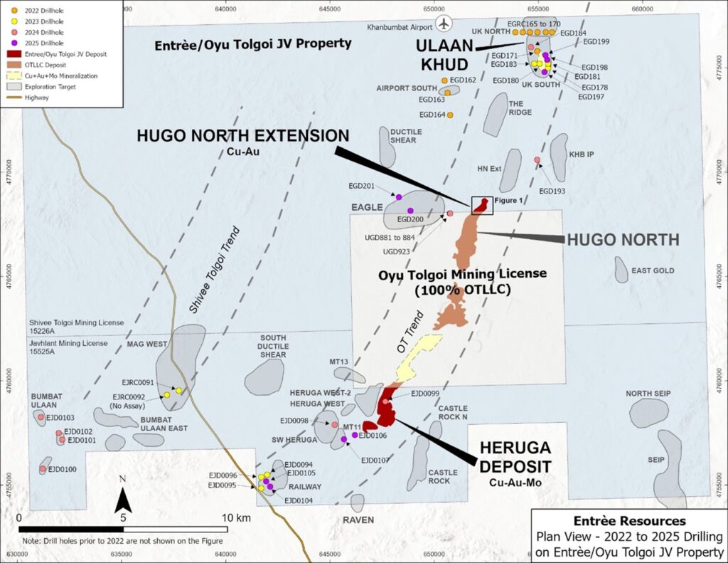
Two diamond drill holes (EGD200 and EGD201) were also completed during 2025 at the Eagle target to test a combined chargeability–magnetic anomaly that coincides with modelled basaltic rocks and a historic molybdenum anomaly. DDH EGD200 intercepted hornfels, part of a contact metamorphic formation over much of the upper part of the drill hole. The hornfels display chlorite-magnetite alteration and disseminated and vein-hosted pyrite-pyrrhotite, magnetite and minor molybdenite. Copper grades over this interval are generally low (<0.1%), with a few narrow, anomalous intervals grading between 0.1% to 0.23% copper. The lower half of the drill hole consists of alternating granodiorite and hornfels breccia. Throughout most of the drill hole molybdenum assays were anomalous (trace to 569 ppm), including a 314 metre higher grade portion between 266 metres and 580 metres that assayed 99 ppm molybdenum, along with low amounts of copper and gold (Table 5).
Drill hole EGD201 intersected granodiorite over much of the drill hole with local hornfels units, but no significant grades were returned.
OT LLC concluded that the chargeability anomaly at the Eagle target was caused by disseminated sulphides in the hornfels and review of the data could not establish additional drill targets. Therefore, no further exploration activity is recommended for the Eagle target.
Drilling at Railway target included 2 holes, EJD0104 and EJD0105 targeting copper-gold intercepts from previous drilling campaigns that are situated within favourable Devonian stratigraphy (augite basalt) overlapping with a high chargeability anomaly. Neither DDH intersected any significant mineralized intervals, even though DDH EJD0104 crossed multiple fault zones with hydrothermal breccias and persistent chlorite-sericite-epidote alteration.
OT LLC concluded that the previously identified copper mineralization of the southern part of the Railway target does not show any depth potential. No further drilling is recommended for the southern part of the Railway target.
Two DDHs were completed at the MT11 target (southwest of the Heruga deposit). The first DDH (EJD0106) targeted a high-chargeability anomaly within Devonian prospective lithology. The second DDH (EJD0107) targeted a historical magnetotelluric anomaly (MT11 target), also within favorable Devonian lithology. Neither DDH intersected any significant mineralization, and the chargeability anomaly remains unexplained. OT LLC recommends further exploration at MT11, targeting deeper mineralization below 1,500 to 2,000 metres depth.
2025 HNE and Regional Drill Hole Information
Collars for the HNE underground drill holes were surveyed using a Leica TS16 instrument and downhole surveys were collected approximately every 30 metres using an EX-Track system. Collars for the HNE and regional surface drill holes were surveyed using either an Emlid Reach RS3 or Trimble GPS R8 GPS system and downhole surveys were collected approximately every 30 metres using an EZ-Track system. The HNE and regional surface drill holes were collared with PQ diameter core (123 mm) and often reduced to HQ (96 mm) core diameter at depth. Underground holes at HNE were collared using HQ diameter and occasionally reduced to NQ (76 mm) at depth .
Drill core from the 5 drill holes reported for HNE and for the 9 regional drill holes were geologically and geotechnically logged at site by OT LLC. All core was saw-cut on site before being bagged and shipped to the laboratory. Samples were either quarter core or half core depending on whether a portion was also used for metallurgical test work or other purposes. Sample lengths generally averaged approximately 2.0 metres and core recovery was recorded as being very good (>95% recovery), except in localized areas of faulting/fracturing.
Core from HNE and the regional drilling was shipped to ALS Laboratory in Ulaanbaatar, Mongolia, for sample preparation. ALS is independent of OT LLC, Rio Tinto and Entrée. At ALS the samples were crushed to <2mm and pulverized to 75μm, then the pulps were shipped directly by ALS to their laboratory in Perth, Australia for analysis. Samples were analyzed for g old by MS61L (four-acid digestion of 0.25g sample paired with ICP-MS) for samples <1 g/t Au and by ICP21 (30g fire assay with ICP-AES) for samples >1.0g/t Au. MS61L was used to analyse a suite of 12 elements, including copper, silver and molybdenum. Copper values greater than approximately 0.75% were further analysed by OG62 (ore grade copper using a 0.4 g sample and a 4-acid digestion with an ICP finish).
OT LLC follows a rigorous quality assurance/quality control program for the sampling programs that includes the regular insertion of standards, blanks and duplicates into the sample stream. The QP is not aware of any drilling, sampling, recovery, or other factors that could materially affect the accuracy or reliability of the data referred to in this disclosure.
Gravity Surveys
Ground gravity surveys were carried out over the central parts of the Shivee Tolgoi and Javkhlant mining licence s during July 25, 2025. The Shivee Tolgoi survey comprised 2,419 gravity stations over 200×100 metre and 100×100 metre grids and the Javkhlant survey comprised 2,857 stations over the same grid configurations. Data collection used high-precision differential GPS and a Scintrex CG-5 gravity meter. Both surveys were designed to in-fill areas of historical gravity readings and then to merge the two datasets. See the figures in the Company’s AIF for the areas of the two gravity surveys.
The Shivee Tolgoi gravity survey covers the projected Oyu Tolgoi mineralized corridor to the north and revealed areas of positive Bouger gravity anomalies in the central, northern, and eastern parts of the survey, with values up to +1.97 mGal (and +0.008 mGal/m², for First Vertical Derivative anomalies). OT LLC suggests that these anomalies could indicate shallow, dense subsurface features, such as Late Devonian quartz monzodiorite intrusions or sulfide-rich miner alized zones, potentially related to the Oyu Tolgoi porphyry system. Overall, a strong Bouger gravity anomaly, about 9 km long and up to 1 km wide, aligns with known mineralization at the south end of the survey at HNE and provides potential exploration targets to the north.
The Javkhlant gravity survey covers the Heruga deposit and also the areas to the east and south of the deposit. The survey revealed areas of strong positive Bouger gravity anomalies in the west-central and northern parts of the survey. This includes a large, 3.5 km long and 750 metre wide northeast trending gravity anomaly that is possibly linked to the Heruga deposit. A second, 1.5 km by 1.6 km, strong Bouger anomaly trends to the northwest and is bordered by low gravity zones, possibly indicating a geological feature.
CSAMT Surveys
The exploration program also competed two large CSAMT surveys, one over the central part of the Shivee Tolgoi mining licenc e, centered on the Oyu Tolgoi mineralized trend to the north of HNE and the other over the central portion of the Javkhlant mining licence in the vicinity of the Heruga deposit. See the figures in the Company’s AIF for the CSAMT survey areas.
CSAMT is an electromagnetic geophysical technique used to map subsurface electrical resistivity by transmitting controlled audio-frequency currents into the ground and measuring the resulting electric and magnetic fields at receiver sites. The surveys were designed to improve the geological understanding of the mineralized structures hosting the Oyu Tolgoi trend of deposits by delineating resistivity contrasts that may be linked to structural, lithological, or alteration features relevant to the mineralization model and to generate new potential exploration targets.
The Shivee Tolgoi CSAMT survey was successful in outlining a broad low resistivity area (~300-500 Ohm-m) coinciding with the Ulaan Khud copper mineralization, however no distinct low-resistivity anomaly was identified.
The Ridge target was previously identified as a discrete Induced Polarization/Resistivity anomaly. Based on the CSAMT survey results and integrated geological interpretation it is interpreted to be part of a broad resistivity anomaly caused by Carboniferous granodiorite, which is less prospective for porphyry mineralization. Therefore, OT LLC considers the Ridge target to be low priority, and no further evaluation is recommended.
The CSAMT survey also identified a low resistivity zone (<200 ohm-m) coinciding with the HNE deposit. The anomaly is interrupted to the north by a fault (the Granodiorite boundary fault) and a Carboniferous volcanic formation to the west and north. Although the northern continuation of HNE remains a target, the CSAMT survey did not result in any significant anomalies in this area.
The KHB IP and Ductile Shear targets were not covered by the CSAMT survey.
The Javkhlant CSAMT survey was successful in outlining the general boundaries of the corridor containing the Heruga mineralization, defined by an area of low resistivity (450-1,000 Ohm-m) and the location of several major faults, such as the Javkhlant fault and the West Boundary fault.
A new potential target has resulted from the CSAMT survey where a low resistivity anomaly (800 to 1,100 Ohm-m) was identified along a deep, northeast trending fault structure, possibly fed by hydrothermal fluid. This anomaly is the area between the south end of the Heruga deposit and the MT11 target, which has seen limited previous drilling. OT LLC plans to conduct further evaluation in this area, including 3D geophysical/geological modelling before potentially drill testing this target.
Another attractive low-resistivity target occurs a few kil ometres to the east of the Heruga deposit and to the north-northeast of the Castle Rock North target. The resistivity response is comparable to the resistivity response at the Heruga deposit and is in an area with no previous drilling.
Geological 3D Modelling
Geological 3D modelling has been initiated over both the Shivee Tolgoi and Javkhlant mining licences, focusing on the main target areas and will incorporate drilling, CSAMT and gravity surveys, previous ground magnetic surveys, geochemical sampling datasets and geological and structural datasets. The purpose of this work is to produce visual representations of subsurface geology and structures and to refine targeting. With this, OT LLC can optimize drill hole design with the aim to identify new shallow and/or deep level copper – gold porphyry mineralization. The results of the modelling are expected in Q2 2026.
QUALIFIED PERSON
The scientific and te chnical information that forms the basis for parts of this news release was reviewed and approved by Robert Cinits (P.Geo.), a Qualified Person as defined by National Instrument 43-101. For further information on the Entrée/Oyu Tolgoi JV Property, see the Company’s Technical Report, titled “Entrée/Oyu Tolgoi Joint Venture Project, Mongolia, NI 43-101 Technical Report”, with an effective date of October 8, 2021, available on the Company’s website at www.EntreeResourcesLtd.com, and on SEDAR+ at www.sedarplus.ca.
ABOUT ENTRÉE RESOURCES LTD.
Entrée Resources Ltd. is a Canadian mining company with a unique carried joint venture interest on a significant portion of one of the world’s largest copper-gold projects – the Oyu Tolgoi project in Mongolia. Entrée has a 20% or 30% carried participating interest in the Entrée/Oyu Tolgoi JV, depending on the depth of mineralization. Royal Gold, Inc. (through its wholly owned Canadian subsidiary International Royalty Corporation) and Rio Tinto are major shareholders of Entrée, beneficially holding approximately 24% and 16% of the shares of the Company, respectively.
Alphamin Resources Corp. (TSX-V:AFM) (JSE AltX:APH) is pleased to... READ MORE
NevGold Corp. (TSX-V:NAU) (OTCQX:NAUFF) (Frankfurt:5E50) is pleas... READ MORE
Aldebaran Resources Inc. (TSX-V: ALDE, OTCQX: ADBRF) is pleased ... READ MORE
Reaching a Definitive Agreement Positions NioCorp to Potentially ... READ MORE


