


![]()
Discovery Silver Corp. (TSX: DSV) (OTCQX: DSVSF) today to reported initial results from four key exploration projects at the Company’s Porcupine Complex, including Hoyle Pond Mine, Borden Mine and Pamour Mine, as well as at Owl Creek, a high-priority target located approximately three kilometres west of Hoyle Pond. The results include assays from a combined total of 85 holes1 (27,640 metres), completed between April 2025 and October 2025, which are part of an overall 140,000 m program being completed. The Company also provided an update on recently initiated drilling programs at the Dome Mine and TVZ Zone adjacent to Hoyle Pond, two key growth projects which have the potential to significantly grow production from the Porcupine Complex.
Key Highlights
Excellent results from resource conversion and expansion drilling2
1.44 gpt over 104.6m, 1.07 gpt over 54.5m
2.03 gpt over 25.8m, 2.18 gpt over 20.5m, 1.20 gpt over 37.8m
3.42 gpt over 19.9m, 1.47 gpt over 57.6m
1.85 gpt over 34.6m, 1.35 gpt over 15.5m
48.82 gpt over 5.0m; 3.40 gpt over 39.8m;1.51 gpt over 38.3m;1.78 gpt
over 39.4m; 1.51 gpt over 34.2m; 1.40 gpt over 44.9m; 0.96 gpt over
86.6m; 1.32 gpt over 40.9m; 1.30 gpt over 27.3m
Multiple high-grade intersections at Owl Creek4 in close proximity to Hoyle Pond
Drilling programs commenced at Dome and Hoyle Pond TVZ Zone
Tony Makuch, Discovery’s CEO, commented: “The drill results announced today support our view that substantial gold remains to be identified at Discovery’s assets at Porcupine. At Hoyle Pond, drilling has continued to extend the S Zone to depth and identified new lenses of mineralization to the west of the existing resource. There also remain numerous attractive targets higher up in the mine to be evaluated during our current drill program. We are also very encouraged by multiple high-grade intersections at Owl Creek, approximately 3 km from Hoyle Pond, which highlight the significant potential for mineralization to extend far to the west. In addition, we recently commenced drilling at TVZ, a large zone directly adjacent to Hoyle Pond, which we expect will become an important new source of production. We are targeting approximately 25,000 m of drilling at TVZ by early next year as we work towards releasing an initial NI 43-101 resource for the project.
“Turning to Borden, drilling has clearly demonstrated the continued extension of the Main Zone and the potential for expansion to the northwest. Borden includes a massive 1,000 km2 land position that is largely unexplored outside of the current mining trend. At Pamour, favourable drill results within and along strike of resources in all three phases of the pit design highlight the opportunity we have to add significant new ounces and to grow the project through continued drilling.
“The re-development of Dome represents a game changer for our Porcupine operations. We are planning to drill approximately 7,500 m, and conduct further analysis of existing data and mineralization models, as we prepare to update the existing 11.0 million ounce inferred mineral resource, including converting a portion of this resource to the Indicated category. We are also working on a new pit design that would not require moving the mill, and would provide access to more than half of the current resource, supporting well over a decade of mining. A study on Dome is advancing which will establish a plan to resume open-pit operations and also evaluate the potential for future underground mining.”
Hoyle Pond Mine
Drilling at the Hoyle Pond Mine included a total of 23 holes (5,877m) to test the lower portion of the S Zone, the largest and highest-grade area of the mine. Of the holes drilled, 10 holes (567 m) were abandoned due to excessive deviation from the target.
The Hoyle Pond Mine is located approximately 20 km northeast of Timmins and in the east portion of the Hoyle Pond volcanic belt adjacent to a major northeast trending flexure and the 1060 fault. Mineralization at the mine occurs in multiple zones of quartz veining between surface and a depth of 2,000 metres along the trend of the main flexure. The S Zone, which is the main focus of the current drill program, lies in the lower east portion of the mine, just east of the 1060 fault (Figure 1).
The 13 holes being reported are the first phase of an overall 40,000 m drill program which is designed to convert and expand inferred resources on the lower and west sides of the S Zone between the 2100 and 2295 levels (Figure 2). All drilling was done from a series of platforms located on the 1860 level and on the north (hanging wall) side of the S Zone.
Drilling to depth includes five new holes near the bottom limit of the inferred resource, with results demonstrating similar grades, widths and grade continuity to previous drilling. Key intercepts from drilling include: 23.95 gpt over 7.1m in hole 27682; 9.88 gpt over 11.5m and 86.09 gpt over 2.1m, including 360.00 gpt over 0.5m, in hole 27701; 150.00 gpt over 1.3m, including 302.00 gpt over 0.4m, in hole 27657; and 9.55 gpt over 1.54m, including 36.3 gpt over 0.40m, in hole 27664 (Table 1).
Drilling to the west was focused between the 2100 and 2200 levels and resulted in a number of favourable intercepts that support the potential for new lenses of mineralization to occur west of the current resource. Key intercepts include: 35.98 gpt over 2.9m in hole 27653; 75.5 gpt over 1.0m and 11.65 gpt over 2.28m, including 31.30 gpt over 0.4m, in hole 27660; and 8.67 gpt over 1.67m, including 19.90 gpt over 0.7m, in hole 27654.
The program is continuing with four drills, which are focused on holes to depth and to the west side of the S Zone. Work is also in progress to develop a strategy for drilling further to the east and to depths of at least 2,500 m with options under consideration including drilling from a potential new exploration drift and drill platform near the 2000 level or Navi drilling from the 1860 level.
Borden Mine
Drilling at the Borden Mine included a total of 19 holes (4,360 m) to convert and expand resources in the northeast portion of the Main Zone which is the host for the majority of gold mineralization at the mine (Figures 3 and 4).
The Borden Mine is located approximately 190 km southwest of the Dome Mill, near to Chapleau and in the south portion of the Borden Lake Greenstone Belt. The Main Zone is an east-west trending structure located along the east – west trending Genesis Deformation Zone adjacent to a major contact between felsic gneiss and amphibolite. Work to date has traced the zone for a strike length of over 1.7 km along strike and indicates the zone is closely associated with quartz veining, biotite-garnet alteration and pyrite.
The holes reported today represent the first phase of a 30,000 m drill program at Borden, including 20,000 m of in-mine drilling designed to cover a 300 m strike length of the Main Zone near the current northeast limit of inferred resources, as well as 10,000 m of drilling focused on district targets around the mine. All in-mine drilling is being planned from cut outs located in the east portion of the 585- exploration drift, situated in the hanging wall of the zone.
Results of the program have been extremely positive and include: 11.48 gpt over 5.2m, including15.49 gpt over 3.2m, in 585-00099; 9.41 gpt over 12.6m, including 19.29 gpt over 5.2m, in 585-00102; 13.88 gpt over 6.9m, including 18.99 gpt over 4.8m, in 585-00159; 6.15 gpt over 23.1m, including 13.21 gpt over 7.8m, in 585-00127; and 8.47 gpt over 8.2m, including 11.52 gpt over 4.6 m, in 585-00126 (Table 2).
From current interpretations, the Main Zone continues to track as planned with grades and widths that are similar to, or better than, the current resource model. These results, along with ongoing wide-spaced surface drilling, located up to 1.2 km to the northeast, establish the potential for further growth as drilling continues.
The program is continuing with three drills working to convert and extend resources. Planning is also in the final stages for a further extension of the exploration drift to the northeast, as well as for the mobilization of a surface drill to the gap between the end of the exploration drift and the wide-spaced surface holes to the northeast.
Pamour
Drilling at the Pamour Mine included a total of 32 holes (10,144 m) to test areas within and surrounding the large open-pit resource at the property, which includes 6.48 million tonnes grading 1.30 gpt (2.70 million ounces) in the Indicated category and 2.33 million tonnes grading 1.34 gpt (1.00 million ounces) in the Inferred category (Figure 5).
The Pamour Mine is located approximately 20 km east of Timmins on the north side of the Destor Porcupine Fault Zone and straddles the unconformity between Tisdale Group volcanics and Timiskaming sediments. Mineralization at the mine is closely associated with quartz veining, which can occur in single veins, vein arrays, stockworks as well as pyrite both along the unconformity and in volcanics to the north.
The holes drilled represent the first phase of a 40,000 m drill program designed to convert and extend inferred resources over the full strike length of the resource pit, which currently stands at approximately 2.3 km. Results from the program to date have been very positive (Table 3).
Significant results in the central portion, which overlie the phase 1 pit, include: 1.44 gpt over 104.6m and 1.07 gpt over 54.5m in PAM25-0012: 2.03 gpt over 25.8m, 2.18 gpt over 20.5m and 1.20 gpt over 37.8m in PAM25-0009; and 48.82 gpt over 5.0m in PAM25-0041.
Results to the west, which lie within the phase 2 pit, include: 3.40 gpt over 39.8m in PAM25-0025;3.42 gpt over 19.9m and 1.47 gpt over 57.6m in PAM25-0018, 1.51 gpt over 38.3m in PAM25-0038; 1.78 gpt over 39.4m in PAM25-36; and 1.85 gpt over 34.6m and 1.35 gpt over 15.5m in PAM25-0024.
Results to the east portion, which overlie the phase 3 pit, include: 1.51 gpt over 34.2m in PAM25-0010, 1.40 gpt over 44.9m in PAM25-0005, 0.96 gpt over 86.6m in PAM25-0068, 1.30 gpt over 27.3m in PAM25-0031 and 1.32 gpt over 40.90m in PAM25-0011.
The drill program is continuing with three drills focusing on the east, west and central areas of the current pit. Planning is also in progress for new exploration drilling along strike, to the east and west, and to depth. Exploration to the west will focus on Broulan and Keora Trends west of the phase 2 pit, while exploration to the east will focus on the AAA Trend which follows the Timiskaming unconformity to east of the phase 3 pit and the historic Hoyle Shaft. Exploration to depth will test various areas along the strike length of the mine, with the focus mainly on areas near the historic Broulan Porcupine pit and the Hoyle shafts, where mining or exploration below the 300 m levels has been limited.
Owl Creek
Drilling at the Owl Creek Project included a total of 11 holes (6,689 m) designed to test for potential strike and depth extensions of mineralization near the former Owl Creek Open Pit (Figure 6). Of the 11 holes drilled, five holes (392 m) were abandoned due to excessive deviation.
The Owl Creek Open Pit is located approximately three kilometres west of the Hoyle Pond Mine and along the south side of the Hoyle Pond belt near the contact between metasedimentary and metavolcanic rocks. The pit, as well as two underground ramps below it, were developed by Falconbridge Gold in the 1980’s and were utilized to recover approximately 237,000 ounces of gold at an average grade of 3.75 gpt.
Holes included in the drill results released today represent the first phase of a 15,000 m regional drill program targeting the potential down-plunge extension of mineralization east of the historic open pit. Historic wide-spaced drilling in this area obtained multiple significant intercepts of gold mineralization between surface and the 750 m level. Significant results from the historic holes include: 10.50 gpt over 8.8m, including 42.83 gpt over 1.6m, in OC10889; 6.26 gpt over 2.6m, 4.07 gpt over 6.3m, including 10.74 gpt over 1.4m, 4.33 gpt over 12.9m, including 15.03 gpt over 1.0m and 96.78 gpt over 3.0m, in OC10927; and 4.3 gpt over 10.1m, including 6.89 gpt over 7.1m, including 14.2 gpt over 1.5m, which tested the zone below the 550 m level.
The new drilling was designed to follow up and extend mineralization from the historic results along strike and to depth. Results from the new holes were highly positive, with intersections including: 4.08 gpt over 16.3m, including 9.81 gpt over 3.9m, and 4.14 gpt over 17.5m, including 6.48 gpt over 10.0m, in OC25-001; 5.58 gpt over 5.2m, including 17.63 gpt over 1.1m, and 5.39 gpt over 11.0m, in OC25-006; and 5.59 gpt over 6.0m in OC25-005B (Table 4).
While the review and interpretation of drilling is still in progress, initial results indicate that the most significant mineralization in both new and historic drill holes occurs near the tip of an easterly plunging wedge of mafic volcanics, which remains open to depth, with holes OC25-005B and OC25-006 representing two of the deepest and farthest east holes drilled along the trend to date.
The program is continuing with three drills that will target both zones near surface and at depth. Planning is also in progress for drilling to test the 750 Zone which is located approximately 850 m to the east of the current target area.
Dome Mine Project
Drilling commenced at the Dome Mine Project at the end of September (Figure 7). Dome is among the largest historic gold producers in Canada, with total production of 16.7 million ounces from both underground and open pit sources between 1910 and 2017.
Geologically, the mine is located on the south limb of the Porcupine Syncline and just north of the Destor Porcupine Fault, with mineralization in multiple zones extending from surface to a depth of approximately 1,600 m.
The current mineral resource at Dome includes 222.3 million tonnes with an average grade of 1.49 g/t for a total of 11.0 million ounces in the Inferred category. The resource assumes a large-scale open-pit concept to expand the historic pit along strike and to depth.
The current drill program involves approximately 7,500 m of drilling being completed in preparation for a new mineral resource estimate and involves drilling in areas surrounding and below the historic pit. The work program also includes further evaluations of data and mineralization models to upgrade portions of the resource to the Indicated resource category and also to evaluate the potential for future underground mining at Dome.
There is presently one drill active at Dome which is focused on two areas on the south side of the current pit that lie within the target area for a first phase pit expansion. Work is also in progress to evaluate additional drill targets to the north, south and below the current pit.
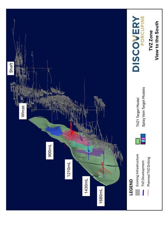
TVZ Project
Drilling commenced at the TVZ Project at the end of October. TVZ is a significant zone of gold mineralization located between the 800 and 1800 m levels in the southeast portion of the Hoyle Pond Mine (Figure 8).
Geologically, TVZ lies in the Porcupine sediments south of the Hoyle Pond Volcanic Belt, just east of the 1060 fault. Gold mineralization is closely associated with a northeast trending steeply dipping shear zone with local splay veins, which plunge moderately to the northeast. The bulk of the mineralization identified to date occurs within a panel measuring approximately 600 m long by 200 m in height, extending from the 850 level to just below the 1410 level, with the best grades typically having a strong correlation with increased amounts of quartz veining, pyrite and arsenopyrite.
Past work at the project includes 437 holes (172,319 m) of wide-spaced drilling from three main platforms on the 900, 1210 and 1410 levels, as well as limited development, mapping, chip sampling and metallurgical test work on the 1210 level. Results from the drilling, mapping and chip sampling have been positive and indicate multiple holes with grades exceeding 5.0 gpt over widths of 5 to 10 m. The results also indicate positive results from the two deepest holes to test the zone to date, holes 21009 and 21094, with returned values of 6.29 gpt over 5.3m and 4.98 gpt over 4.0m, respectively, between the 1550 and 1610 levels. As a result, the potential to extend the zone to greater depths is considered excellent.
Results of the past metallurgical work indicate a strong correlation of gold with arsenopyrite and variable recoveries, but with the potential for improvement using enhanced processing.
The current work program is designed to infill and expand the TVZ Zone in preparation for an initial NI 43-101 mineral resource. The program is targeted to include a minimum of 25,000 m of new drilling from the 900, 1210, 1410 and 1680 levels by the end of the first quarter of 2026.
Drilling is being conducted using one drill located on the 1680 level, which is testing the projected extension of the TVZ Zone down plunge from the 1410 level. Two additional drills are in the process of being mobilized on the 1210 level that will conduct infill and expansion drilling near the mid-point of the historic work.
ABOUT DISCOVERY
Discovery is a growing North American-focused precious metals company. The Company has exposure to silver through its first asset, the 100%-owned Cordero project, one of the world’s largest undeveloped silver deposits, which is located close to infrastructure in a prolific mining belt in Chihuahua State, Mexico. On April 15, 2025, Discovery completed the acquisition of the Porcupine Complex from Newmont Corporation, transforming the Company into a new Canadian gold producer with multiple operations in one of the world’s most renowned gold camps in and near Timmins, Ontario. Discovery owns a dominant land position within the camp, with a large base of Mineral Resources remaining and substantial growth and exploration upside.
On Behalf of the Board of Directors,
Tony Makuch, P. Eng
President, CEO & Director
For further information contact:
Mark Utting, CFA
SVP Investor Relations
Phone: 416-806-6298
Email: mark.utting@discoverysilver.com
Website: www.discoverysilver.com
| Table 1: Intercepts from Hoyle Pond Underground Mine1,2 | |||||||
| Hole ID | Total Hole Depth |
From | To | Core length |
Estimated True Width |
Au | Notes |
| (m) | (m) | (m) | (m) | (g/t) | |||
| 27651 | 410 | 358.0 | 358.8 | 0.8 | 0.8 | 0.13 | NSV |
| 27652 | 450 | 381.9 | 383.1 | 1.2 | 1.2 | 0.13 | NSV |
| 27653 | 411 | 385.0 | 388.0 | 3.0 | 2.9 | 35.98 | Visible Gold |
| 27657 | 477 | ||||||
| 472.4 | 473.9 | 1.5 | 1.3 | 150.00 | Visible Gold | ||
| incl | |||||||
| 472.8 | 473.3 | 0.5 | 0.4 | 302.00 | |||
| 27654 | 430 | 373.6 | 375.4 | 1.8 | 1.5 | 8.67 | Visible Gold |
| incl | |||||||
| 374.7 | 375.4 | 0.7 | 0.7 | 19.90 | |||
| 27660 | 430 | 376.0 | 377.0 | 1.0 | 1.0 | 75.50 | Visible Gold |
| 379.4 | 382.0 | 2.6 | 2.3 | 11.65 | |||
| incl | |||||||
| 379.4 | 379.8 | 0.4 | 0.4 | 31.30 | |||
| incl | |||||||
| 381.5 | 382.0 | 0.5 | 0.5 | 30.40 | |||
| 27656 | 445.7 | NSV | |||||
| 27662 | 420 | 364.6 | 366.4 | 1.8 | 1.7 | 44.54 | Visible Gold |
| 27682 | 501 | 471.1 | 479.8 | 8.7 | 7.1 | 23.95 | Visible Gold |
| 27664 | 450 | 393.7 | 395.4 | 1.7 | 1.5 | 9.55 | Visible Gold |
| incl | |||||||
| 394.7 | 395.1 | 0.4 | 0.4 | 36.30 | |||
| 27701 | 411 | 363.7 | 365.8 | 2.1 | 1.8 | 86.09 | Visible Gold |
| Incl | |||||||
| 363.7 | 364.2 | 0.5 | 0.4 | 360.00 | |||
| 365.8 | 379.1 | 13.3 | 11.5 | 9.88 | |||
| 27663 | 474 | NSV | |||||
| 27661 | 450 | NSV | |||||
| Table 2: Intercepts from Borden Underground Mine1,2 | |||||||||||
| Hole ID | Total Hole Depth |
From | To | Core length |
Estimated True Width |
Au | Notes | ||||
| (m) | (m) | (m) | (m) | (g/t) | |||||||
| 585-00099 | 234.0 | 200.7 | 206.8 | 6.1 | 5.2 | 11.48 | |||||
| Incl | |||||||||||
| 203.0 | 206.8 | 3.8 | 3.2 | 15.49 | |||||||
| 585-00101 | 215.4 | 190.6 | 198.8 | 8.2 | 6.8 | 6.14 | |||||
| 585-00102 | 200.0 | 177.6 | 192.0 | 14.4 | 12.6 | 9.41 | |||||
| incl | |||||||||||
| 185.2 | 191.2 | 6.0 | 5.2 | 19.29 | |||||||
| 585-00104 | 220.0 | 181.0 | 185.6 | 4.6 | 3.7 | 3.11 | |||||
| 585-00105 | 190.0 | 162.9 | 173.3 | 10.4 | 9.1 | 3.24 | |||||
| incl | |||||||||||
| 168.1 | 173.3 | 5.2 | 4.5 | 4.20 | |||||||
| 585-00106 | 190.0 | 168.35 | 175.1 | 6.8 | 6.3 | 6.57 | |||||
| Incl | |||||||||||
| 171 | 175.1 | 4.1 | 3.8 | 10.10 | |||||||
| 585-00128 | 226.0 | 203.3 | 210.0 | 6.7 | 6.3 | 7.49 | |||||
| Incl | |||||||||||
| 203.7 | 207.3 | 3.6 | 3.4 | 11.01 | |||||||
| 585-00107 | 197.0 | 167.0 | 178.4 | 11.0 | 10.2 | 4.21 | |||||
| Incl | |||||||||||
| 170.73 | 175.8 | 5.1 | 4.6 | 7.04 | |||||||
| 585-00100 | 217.0 | 153.7 | 165.2 | 11.5 | 9.9 | 4.91 | |||||
| incl | |||||||||||
| 154.4 | 163.5 | 9.1 | 7.9 | 5.30 | |||||||
| 182.0 | 187.4 | 5.4 | 4.9 | 7.27 | |||||||
| incl | |||||||||||
| 183.3 | 186.9 | 3.6 | 3.2 | 8.78 | |||||||
| 585-00103 | 236.0 | NSV | |||||||||
| 585-00111 | 235.0 | NSV | |||||||||
| 585-00124 | 279.0 | 238.2 | 244.7 | 6.5 | 5.2 | 4.91 | |||||
| incl | |||||||||||
| 239.5 | 244.7 | 5.2 | 4.1 | 5.85 | |||||||
| 585-00125 | 213.6 | 193.4 | 200.0 | 6.6 | 6.0 | 15.61 | |||||
| 585-00159 | 284.2 | 248.6 | 256.0 | 7.4 | 6.9 | 13.88 | |||||
| incl | |||||||||||
| 248.6 | 253.8 | 5.2 | 4.8 | 18.99 | |||||||
| 585-00160 | 322.0 | 281.0 | 287.0 | 6.0 | 5.2 | 9.99 | |||||
| 585-00127 | 217.6 | 182.4 | 210.6 | 28.3 | 23.1 | 6.15 | |||||
| Incl | |||||||||||
| 191.2 | 199.0 | 7.8 | 6.4 | 13.21 | |||||||
| 585-00234 | 250.1 | 179.1 | 188.0 | 8.9 | 7.4 | 5.15 | |||||
| 208.7 | 213.3 | 4.6 | 3.7 | 4.91 | |||||||
| Incl | |||||||||||
| 209.4 | 212.4 | 3.0 | 2.5 | 6.93 | |||||||
| 585-00123 | 209.9 | 176.6 | 188.5 | 11.2 | 10.9 | 7.60 | |||||
| incl | |||||||||||
| 176.6 | 182.4 | 5.7 | 5.3 | 11.34 | |||||||
| 192.0 | 202.6 | 10.1 | 8.9 | 3.85 | |||||||
| incl | |||||||||||
| 193.9 | 196.4 | 2.5 | 2.2 | 8.89 | |||||||
| 585-00126 | 223.5 | 199.0 | 208.0 | 8.9 | 8.5 | 8.20 | |||||
| Incl | |||||||||||
| 203.12 | 207.97 | 4.9 | 4.6 | 11.52 | |||||||
| Table 3: Intercepts from the Pamour Open Pit Mine1,2 | ||||||||
| Hole ID | Total hole Depth | From | To | Core length | Au | Notes | ||
| (m) | (m) | (m) | (g/t) | |||||
| PAM25-0001 | 408 | 121.5 | 132.8 | 11.3 | 0.81 | 4.93gpt/1.5m | ||
| 152.3 | 178.9 | 26.6 | 0.92 | 4.71gpt/0.7m | ||||
| 6.14gpt/0.5m 4.85gpt/0.5m |
||||||||
| 387.8 | 397 | 9.2 | 0.96 | |||||
| 4.80gpt/1.0m | ||||||||
| PAM25-0002 | 423 | 163.0 | 185.5 | 22.5 | 0.80 | |||
| 6.28gpt/1.0m | ||||||||
| 220.0 | 232.9 | 12.9 | 0.71 | |||||
| 359.0 | 375.0 | 16.0 | 1.56 | |||||
| 6.14gpt/1.0m 4.50gpt / 0.5m |
||||||||
| 7.68gpt/0.5m | ||||||||
| 4.42gpt/0.6m | ||||||||
| PAM25-0003 | 416.0 | 314.0 | 324.0 | 10.0 | 0.89 | |||
| PAM25-0005 | 315.0 | 202.0 | 246.9 | 44.9 | 1.40 | |||
| 6.26gpt / 0.3m 6.43gpt / 0.3m 6.03gpt / 0.5m 4.64gpt / 1.0m 12.30gpt / 0.6m 4.64gpt / 0.8m 12.00gpt / 0.6m |
||||||||
| PAM25-0006ALR | 132 | 64.5 | 72.9 | 8.4 | 0.75 | |||
| 114.6 | 127.8 | 13.2 | 1.68 | 8.90gpt/0.4m | ||||
| 6.60gpt/0.8m | ||||||||
| PAM25-0006LR | 138 | 67.0 | 87.0 | 20.0 | 0.68 | |||
| 115.5 | 130.9 | 15.4 | 0.81 | |||||
| PAM25-0008 | 148 | 63.6 | 72.0 | 8.4 | 1.05 | |||
| 142.7 | 148.6 | 5.9 | 0.83 | |||||
| PAM25-0010 | 315 | 189.8 | 224.0 | 34.2 | 1.51 | 6.04 gpt/1.0m | ||
| PAM25-0012 | 435 | 189.9 | 244.4 | 54.5 | 1.07 | 142.00gpt/0.3m | ||
| 261.4 | 366.0 | 104.6 | 1.44 | 5.85 gpt/0.3m | ||||
| 31.90 gpt/1.1m | ||||||||
| 61.70 gpt/0.6m | ||||||||
| 10.60 gpt/0.7m | ||||||||
| 9.03 gpt/0.3m | ||||||||
| 12.00gpt/0.4m | ||||||||
| PAM25-0013 | 91.5 | 65.0 | 77.0 | 12.0 | 0.79 | 5.27gpt / 0.4m | ||
| PAM25-0014 | 486.2 | 103.2 | 124.6 | 21.4 | 0.74 | 12.00gpt / 0.8 m | ||
| 7.60gpt / 0.5 m | ||||||||
| PAM25-0016 | 111 | 32.0 | 49.2 | 17.2 | 0.63 | Hole did not go to full planned depth due to breakthrough | ||
| PAM25-0018 | 267 | 25.1 | 45.0 | 19.9 | 3.42 | 6.90gpt / 5.5m | ||
| 105.8 | 117.6 | 11.8 | 0.49 | |||||
| 159.0 | 216.6 | 57.6 | 1.47 | 17.00gpt / 1.3 m | ||||
| 9.50gpt / 1.0 m | ||||||||
| 17.10gpt / 0.3 m | ||||||||
| 6.70gpt / 0.8 m | ||||||||
| 11.40gpt / 0.7 m | ||||||||
| 10.00gpt / 0.3 m | ||||||||
| 9.20gpt / 0.5m | ||||||||
| PAM25-0009 | 351 | 93.1 | 99.5 | 6.4 | 0.96 | 5.60gpt / 0.8m | ||
| 117.5 | 130.7 | 13.2 | 0.61 | |||||
| 168.8 | 194.6 | 25.8 | 2.03 | 8.5 gpt / 0.3m | ||||
| 10.5 gpt / 0.3 m | ||||||||
| 6.19 gpt / 0.8 m | ||||||||
| 17.70gpt / 0.7m | ||||||||
| 205.0 | 225.5 | 20.5 | 2.18 | 6.00 gpt / 1.0 m | ||||
| 10.50gpt / 0.3m | ||||||||
| 11.70gpt / 1.4m | ||||||||
| 247.8 | 256.0 | 8.2 | 0.99 | |||||
| 264.8 | 302.6 | 37.8 | 1.20 | 11.80gpt / 0.6 m 9.70gpt / 0.6 m 5.90gpt / 0.9 m |
||||
| PAM25-0011 | 432 | 202.8 | 243.7 | 40.9 | 1.32 | 6.40 gpt / 0.6 m 6.10 gpt / 1 m 6.40gpt / 0.3 m 8.50 gpt / 0.9 m |
||
| 282.0 | 289.0 | 7.0 | 0.69 | |||||
| 297.0 | 304.5 | 7.5 | 2.18 | 12.80gpt / 1.0m | ||||
| PAM25-0019 | 330 | 208.0 | 245.0 | 37.0 | 1.74 | 15.60gpt / 1.0m | ||
| 282.0 | 301.8 | 19.8 | 0.50 | |||||
| PAM25-0021 | 255 | 31.3 | 40.2 | 8.9 | 2.08 | 4.90gpt / 1.0m | ||
| 57.0 | 63.6 | 6.6 | 1.37 | 12.10gpt /0.6 m | ||||
| 99.6 | 104.7 | 5.1 | 0.87 | 4.80gpt / 0.6 m | ||||
| 139.0 | 144.5 | 5.5 | 1.43 | |||||
| 158.5 | 180.3 | 21.8 | 0.74 | 4.80 gpt / 0.7 m | ||||
| 198.0 | 226.0 | 28.0 | 1.02 | 14.10gpt / 0.6 m | ||||
| 6.80gpt / 0.7 m | ||||||||
| PAM25-0025 | 300 | 92.5 | 99.9 | 7.4 | 3.46 | 37.70gpt / 0.5m | ||
| 223.2 | 263.0 | 39.8 | 3.40 | 6.00 gpt / 14.7m | ||||
| 5.40 gpt / 0.4m | ||||||||
| 8.10 gpt / 1.0m | ||||||||
| 5.90 gpt / 0.5m | ||||||||
| 291.0 | 298.5 | 7.5 | 1.48 | 4.50gpt /0.5 m | ||||
| PAM25-0033 | 375 | 76.0 | 81.5 | 5.5 | 0.82 | 5.50 gpt /0.3m | ||
| 180.0 | 187.0 | 7.0 | 2.52 | 56.40gpt /0.3m | ||||
| PAM25-0029 | 340 | 82.0 | 113.5 | 31.5 | 0.68 | |||
| 186.0 | 214.0 | 28.0 | 0.73 | |||||
| PAM25-0020 | 456 | 112.4 | 117.8 | 5.4 | 0.91 | 15.90 gpt/ 0.3m | ||
| 127.4 | 133.5 | 6.1 | 0.61 | 5.66 gpt/ 0.3m | ||||
| 193.5 | 199.3 | 5.8 | 0.80 | 6.08 gpt / 0.4m | ||||
| 280.2 | 303.0 | 22.8 | 0.89 | 9.96 gpt / 0.5 m | ||||
| 17.50 gpt / 0.6 m | ||||||||
| 326.5 | 332.7 | 6.2 | 1.91 | 34.90 gpt / 0.3m | ||||
| 382.0 | 412.0 | 24.0 | 1.04 | 12.50gpt / 1.0m | ||||
| 8.66 gpt / 0.4m | ||||||||
| 5.55 gpt / 0.4m | ||||||||
| PAM25-0007 | 402 | 226.5 | 271.2 | 44.7 | 0.87 | 14.60gpt / 0.7m | ||
| 379.9 | 394.5 | 6.0 | 4.14 | 24.00gpt / 0.8 m | ||||
| PAM25-0031 | 339 | 217.5 | 244.8 | 27.3 | 1.30 | 8.30gpt / 1.0 m | ||
| PAM25-0024 | 264 | 26.5 | 42.0 | 15.5 | 1.35 | 5.31gpt / 0.3 m | ||
| 89.0 | 96.0 | 7.0 | 3.15 | 16.60 gpt / 0.8m | ||||
| 141.1 | 175.7 | 34.6 | 1.85 | 64.70 gpt / 0.4m | ||||
| 21.10 gpt / 0.5m | ||||||||
| 19.20 gpt / 0.5m | ||||||||
| 208.0 | 225.0 | 17.0 | 1.20 | 15.10 gpt / 0.5m | ||||
| PAM25-0034 | 195 | 43.5 | 52.0 | 8.5 | 9.61 | 38.00 gpt / 2.0m | ||
| 67.0 | 86.8 | 19.8 | 0.82 | |||||
| 187.4 | 193.7 | 6.3 | 2.68 | 6.90 gpt / 1.2m | ||||
| PAM25-0036 | 402 | 100.4 | 116.5 | 16.1 | 1.11 | |||
| 297.0 | 324.8 | 27.8 | 0.67 | |||||
| 331.1 | 370.5 | 39.4 | 1.78 | 8.80gpt / 0.6 m | ||||
| 10.20gpt / 0.5 m | ||||||||
| 7.30gpt / 1.0 m | ||||||||
| PAM25-0044 | 291 | 60.9 | 98.0 | 37.1 | 0.93 | 5.62gpt / 0.6 m | ||
| 230.7 | 280.0 | 49.3 | 1.16 | 7.39gpt / 0.4 | ||||
| 5.57 gpt / 0.3 m | ||||||||
| 6.93 gpt / 0.3 m | ||||||||
| 5.74 gpt / 1.0 m | ||||||||
| PAM25-0054 | 327 | 202.6 | 209.6 | 7.0 | 0.89 | |||
| 273.0 | 293.0 | 20.0 | 0.88 | 9.29 gpt / 0.3 m | ||||
| PAM25-0041 | 423 | 394.3 | 398.3 | 5.0 | 48.82 | 396.00 gpt/0.6m | ||
| PAM25-0028 | 283 | 85.0 | 100.3 | 15.3 | 2.48 | |||
| 215.0 | 221.0 | 6.0 | 1.42 | |||||
| 222.0 | 282.5 | 60.5 | 0.97 | |||||
| PAM25-0038 | 300 | 38.7 | 77.0 | 38.3 | 1.51 | |||
| PAM25-0068 | 393 | 212.0 | 298.6 | 86.6 | 0.96 | |||
| Table 4: Intercepts from New Drilling at Owl Creek Project1,2 | |||||||||
| Hole ID | Total Hole Depth |
From | To | Core length |
Estimated True Width |
Au | Notes | ||
| (m) | (m) | (m) | (m) | (g/t) | |||||
| OC25-001 | 824.8 | 670.9 | 687.2 | 16.3 | 4.08 | ||||
| Incl. | |||||||||
| 681.8 | 685.7 | 3.9 | 9.81 | ||||||
| 705.7 | 723.2 | 17.5 | 4.14 | ||||||
| Incl. | |||||||||
| 713.2 | 723.2 | 10.0 | 6.48 | ||||||
| OC25-004A | 1100 | 892.6 | 897.4 | 4.8 | 2.18 | ||||
| 917.0 | 947.5 | 30.5 | 0.48 | ||||||
| Incl | |||||||||
| 928.5 | 933.5 | 5.0 | 1.07 | ||||||
| OC25-005B | 1203 | 813.0 | 822.0 | 9.0 | 4.08 | ||||
| Incl: | |||||||||
| 816.0 | 819.0 | 3.0 | 9.75 | ||||||
| 833.0 | 836.0 | 3.0 | 2.58 | ||||||
| OC25-006 | 930 | 667.3 | 672.5 | 5.2 | 5.58 | ||||
| Incl | |||||||||
| 668.4 | 669.5 | 1.1 | 17.63 | ||||||
| 707.0 | 710.1 | 3.1 | 2.75 | ||||||
| 739.0 | 750.0 | 11.0 | 5.39 | ||||||
| Incl | |||||||||
| 741.5 | 742.0 | 0.5 | 14.20 | ||||||
| 768.0 | 773.1 | 5.1 | 1.68 | ||||||
| OC25-006W1 | 954 | 423.5 | 426.7 | 3.2 | 4.34 | ||||
| including | |||||||||
| 426.4 | 426.7 | 0.3 | 29.50 | ||||||
| 652.0 | 655.0 | 3.0 | 1.91 | ||||||
| 667.5 | 675.0 | 7.5 | 1.28 | ||||||
| 685.0 | 712.0 | 27.0 | 1.93 | ||||||
| including | |||||||||
| 685.5 | 692.8 | 7.3 | 4.04 | ||||||
| 692.8 | 697.0 | 4.2 | 1.89 | ||||||
| 709.5 | 713.0 | 3.5 | 2.73 | ||||||
| including | |||||||||
| 711.1 | 711.5 | 0.4 | 16.20 | ||||||
| OC25-007A | 1285.2 | 383.0 | 390.0 | 7.0 | 2.48 | ||||
| including | |||||||||
| 383.0 | 384.0 | 1.0 | 12.60 | ||||||
| 395.1 | 399.0 | 3.9 | 2.02 | ||||||
| 411.0 | 414.0 | 3.0 | 3.04 | ||||||
| 422.0 | 425.0 | 3.0 | 2.69 | ||||||
| including | |||||||||
| 422.0 | 422.5 | 0.5 | 14.60 | ||||||
FIGURE 1: HOYLE POND
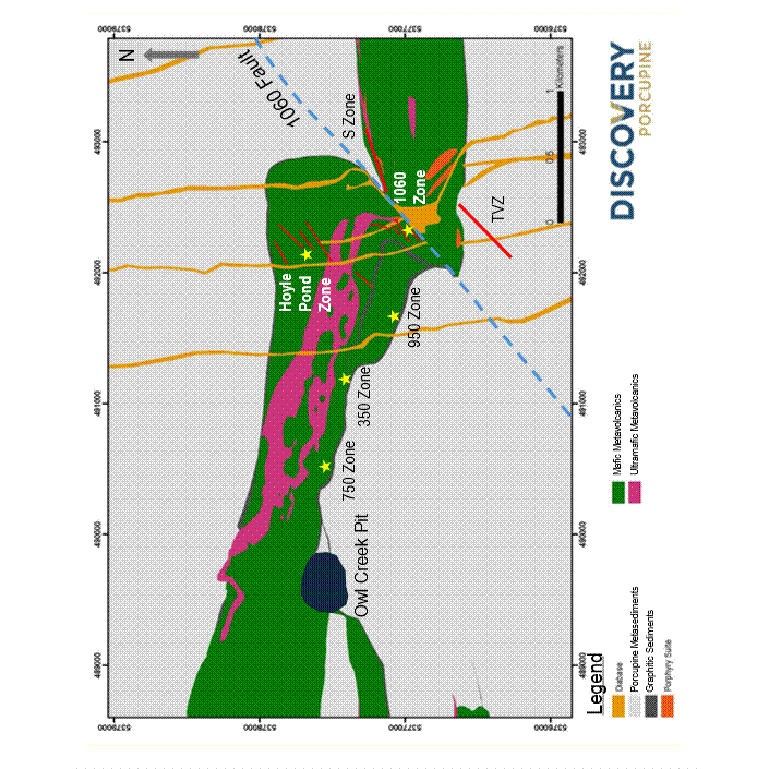
FIGURE 2: HOYLE POND – S ZONE LOWER DRILL RESULTS
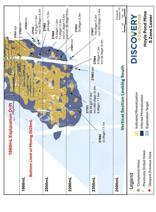
FIGURE 3: BORDEN MINE
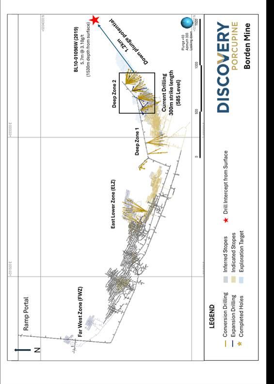
FIGURE 4: BORDEN – DEEP ZONE
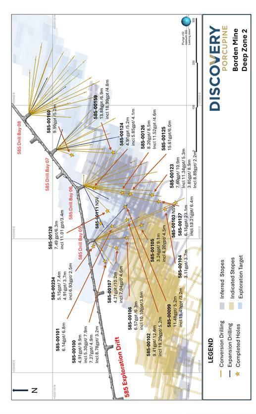
FIGURE 5: PAMOUR
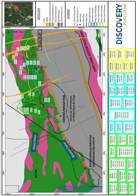
FIGURE 6: OWL CREEK – PLAN VIEW
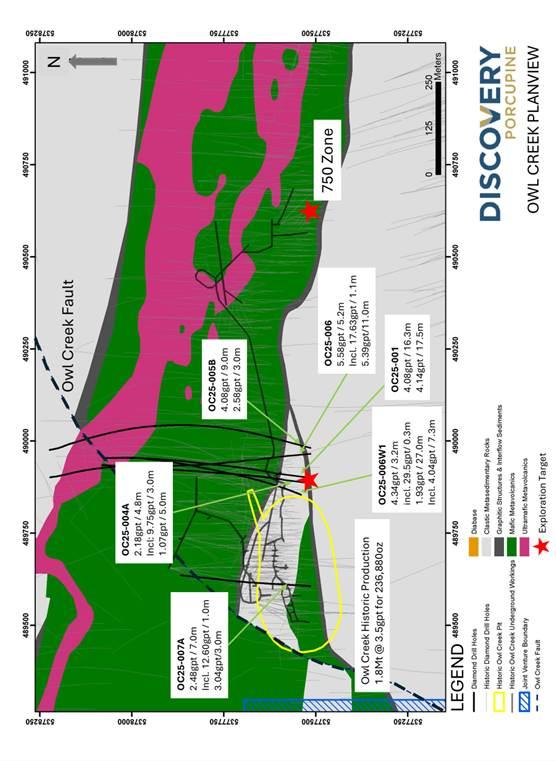
FIGURE 7: DOME
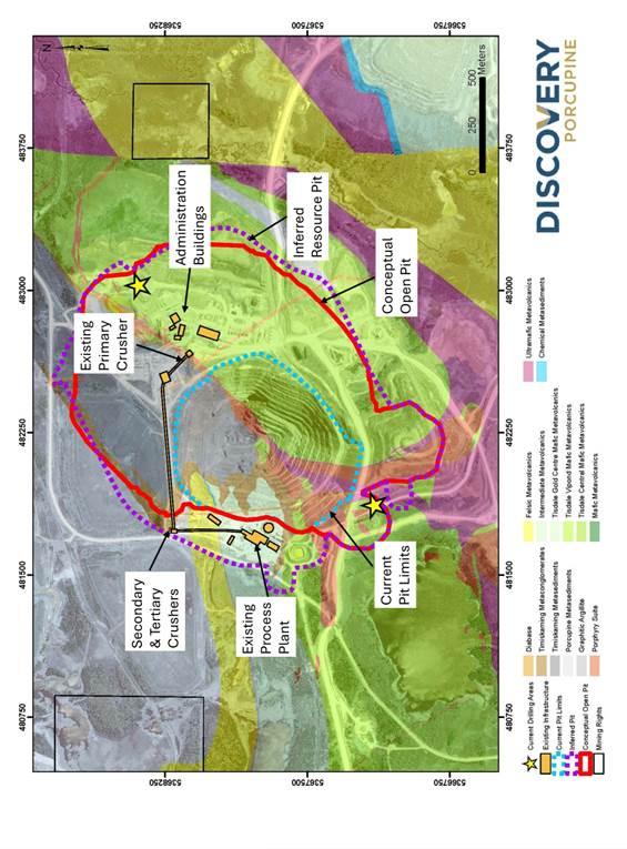
FIGURE 8: TVZ ZONE – VIEW TO SOUTHEAST
Hudbay Minerals Inc. (TSX:HBM) (NYSE: HBM) today released its ann... READ MORE
Strategic acquisition of an established operating gold mine, loca... READ MORE
Cerro de Pasco Resources Inc. (TSX-V: CDPR) (OTCQB: GPPRF) (FRA: ... READ MORE
The Garneau Titanium Project Features Ilmenite-Rich Boulder with ... READ MORE
ValOre Metals Corp. (TSX‐V: VO) (OTCQB: KVLQF) (Frankfurt: KEQ0... READ MORE


