








Hole 399: 4.60 m of 503 g/t Silver
Hole 408: 7.00 m of 290 g/t Silver including 2.00 m of 958 g/t Silver
Brixton Metals Corporation (TSX-V: BBB) (OTCQX: BBBXF) is pleased to report additional silver results from 33 holes at its wholly owned Langis Silver Project, located in the historic silver mining camp of Cobalt, Ontario, Canada. The results reported herein extend mineralization approximately 50 m to the south within the Shaft 6 South East (S6-SE) zone, where hole LM-26-399 returned 41.00 m of 79.2 g/t silver, and include encouraging initial results from the Shaft 6 West (S6-W) area, where hole LM-26-401 returned 2.00 m of 447 g/t silver and mineralization is now confirmed around the historic mine workings. In the Shaft 6 (S6) area, hole LM-26-432 returned 1.00 m of 6,199 g/t silver from 116.05 m depth, including 0.50 m of 12,386 g/t silver. So far in 2026, a total of 33,858 m has been completed across 155 drill holes. Two rigs continue to operate at Langis, testing extensions of known mineralization.
Highlights
Chairman and CEO, Gary R. Thompson, stated, “Drilling at Langis continues to show strong silver results with hole LM-26-432 returning over 12 kilograms of silver per tonne. The disseminated native silver flanking the veins in holes like 399 suggests the mineralized envelopes are wider than the historic vein-only model implied. Our current strategy remains to expand known silver zones in and around the historic mine workings.”
Figure 1. Langis Silver Project location map of drilling area.
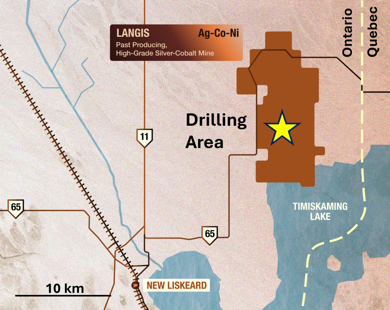
Figure 2. Photograph of hole LM-26-432 at 116.36 m depth showing disseminated native silver and native silver veins-veinlets.
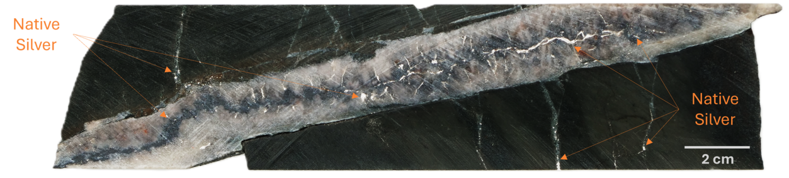
Figure 3. Photograph of hole LM-26-432 at 116.36 m depth showing native silver veins-veinlets.
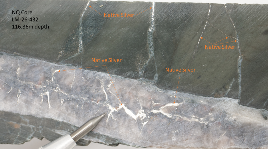
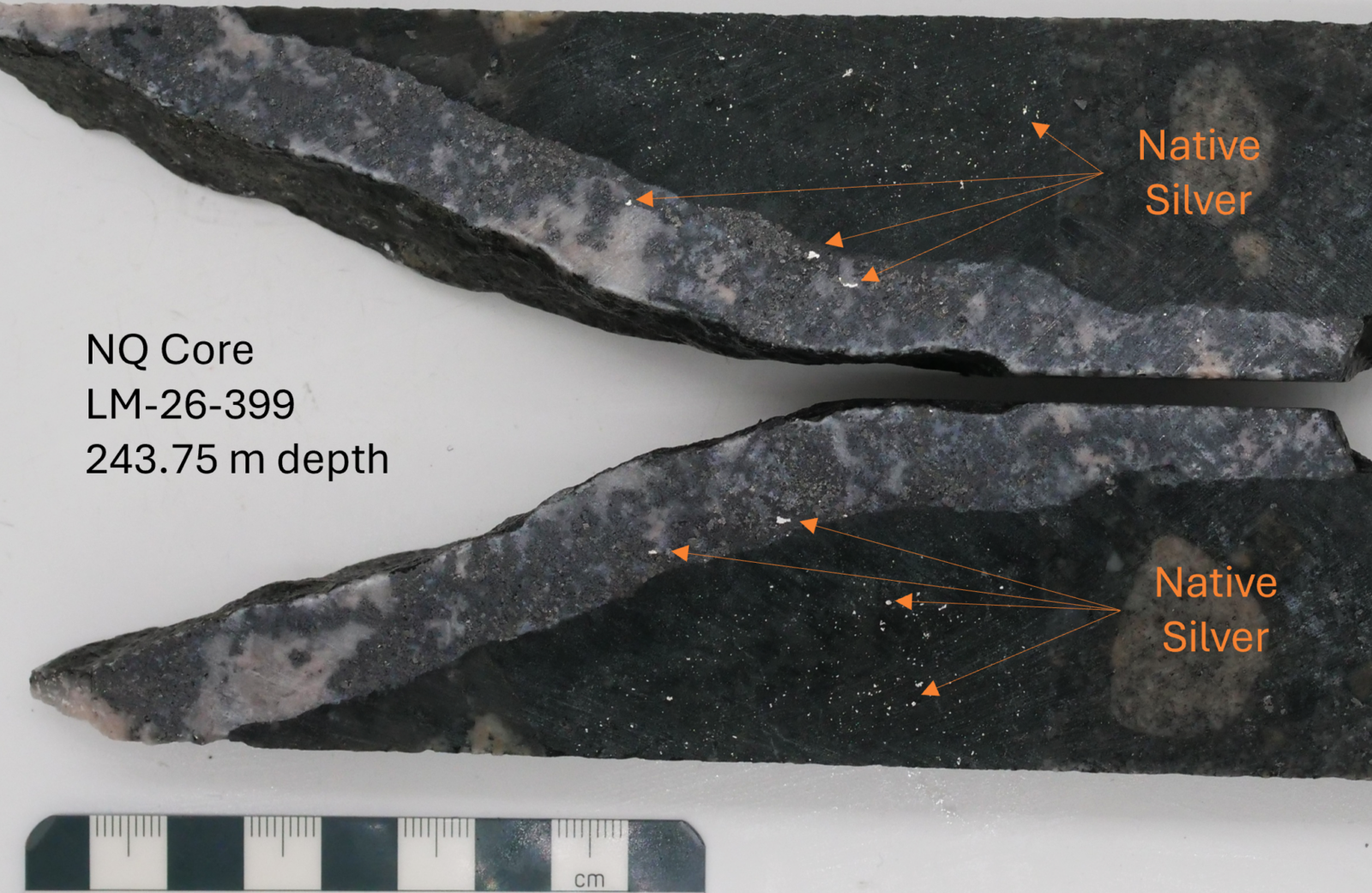
Figure 4. Photograph of hole LM-26-399 at 243.75 m depth showing disseminated native silver and silver carbonate cobaltite veins.
Discussion
Shaft 6 South East (S6-SE)
New results from this recently discovered brownfield area (Table 1), with no mining works (see news release dated, July 21, 2026), show the extension of mineralization to the south. Hole LM-26-399 was collared approximately 50 m south of previously reported hole LM-26-377. Both holes returned silver mineralization over intervals of tens of metres, demonstrating continuity of the vein system within the Shaft 6 South East (S6-SE) zone. As previously reported, hole LM-26-377 returned 20.00 m of 5,015 g/t silver from 165.00 m depth, including 14.00 m of 7,150 g/t silver, 1.15 m of 74,137 g/t silver and 0.65 m of 89,125 g/t silver. Hole LM-26-399 returned 41.00 m of 79.2 g/t silver from 208.00 m depth, including 4.60 m of 503 g/t silver from 213.35 m depth, as well as 7.90 m of 94.7 g/t silver from 241.10 m depth, including 0.55 m of 1,085 g/t silver from 243.15 m depth.
As observed in Figure 4, disseminated native silver accompanies the vein-hosted mineralization. Brixton interprets this as an upside to the traditional vein-focused exploration approach at Langis, as the disseminated silver appears to create broad shoulders of mineralization flanking the veins, which could significantly widen the mineralized envelopes and help expand a potential resource.
Shaft 6 West (S6-W)
Initial results from the Shaft 6 West (S6-W) area, presented in Table 2, are also encouraging and indicate that mineralization extends around the historic mine workings in this zone.
Hole LM-26-401 is a good example, returning 2.00 m of 447 g/t silver from 111.00 m depth, including 0.50 m of 1,735 g/t silver. Silver mineralization at 111.00 m is observed disseminated and in carbonate cobaltite veins. Brixton intends to continue drilling S6-W to expand mineralization, as the Company has been doing in the Shaft 6 South (S6-S) and S6-SE areas.
Other areas
As shown in Table 3, Brixton continues to drill test additional targets in the surrounding Shaft 6, Shaft 6 North and Shaft 6 South areas. Highlights include hole LM-26-432, which returned 1.00 m of 6,199 g/t silver from 116.05 m depth, including 0.50 m of 12,386 g/t silver from 116.05 m depth (Figures 2 and 3), hole LM-26-408, which returned 7.00 m of 290 g/t silver from 123.00 m depth, including 2.00 m of 958 g/t silver from 126.00 m depth, hole LM-26-394, which returned 2.00 m of 236 g/t silver from 122.00 m depth, and hole LM-26-382, which returned 0.90 m of 710 g/t silver from 131.00 m depth. This reflects the Company’s dual exploration strategy at Langis: to expand known mineralized zones while also testing prospective ground for new discoveries.
Figure 5. Plan Map of Langis showing the drill hole collars and traces reported in this news release, along with 2026 drill collars, historic and Brixton assay results projected to surface, and the historic tailings outline.
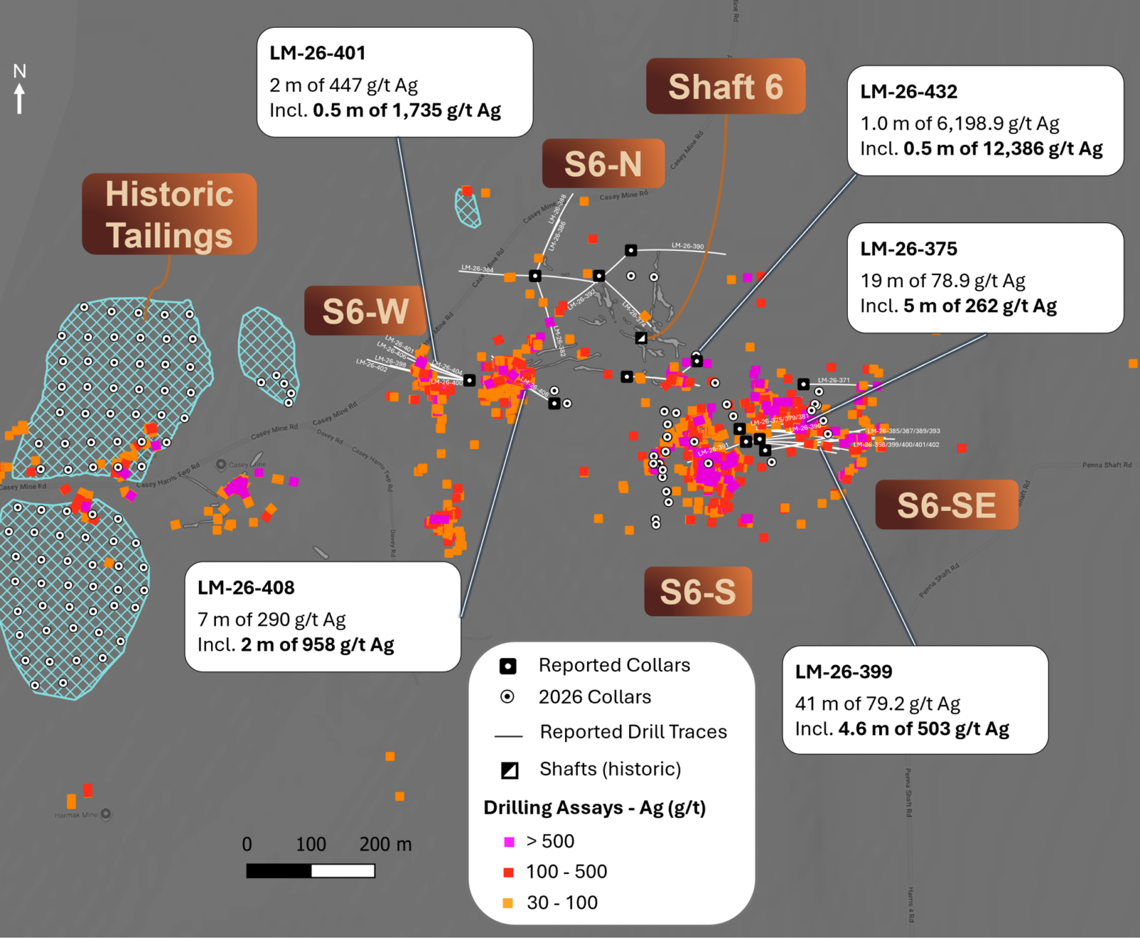
Table 1. Selected assay intervals from drill holes in the Shaft 6 South East Area (S6-SE).
| Hole ID | From (m) | To (m) | Length (m) | Ag (g/t) |
| LM-26-371 | 230.00 | 237.00 | 7.00 | 108.13 |
| including | 235.00 | 236.00 | 1.00 | 693.00 |
| LM-26-375 | 172.00 | 191.00 | 19.00 | 78.90 |
| including | 182.00 | 187.00 | 5.00 | 262.28 |
| LM-26-379 | 153.00 | 163.90 | 10.90 | 32.87 |
| including | 154.85 | 157.00 | 2.15 | 122.49 |
| LM-26-385 | 174.00 | 195.65 | 21.65 | 35.61 |
| including | 176.00 | 177.00 | 1.00 | 153.00 |
| including | 180.00 | 180.50 | 0.50 | 99.00 |
| including | 183.30 | 185.00 | 1.70 | 57.60 |
| including | 186.10 | 187.60 | 1.50 | 96.00 |
| 217.80 | 229.90 | 12.10 | 80.14 | |
| including | 222.00 | 224.00 | 2.00 | 50.80 |
| including | 228.00 | 229.90 | 1.90 | 410.00 |
| LM-26-393 | 162.00 | 179.00 | 17.00 | 51.13 |
| including | 167.00 | 169.00 | 2.00 | 332.00 |
| LM-26-395 | 166.00 | 168.00 | 2.00 | 77.60 |
| 184.00 | 190.00 | 6.00 | 121.02 | |
| including | 186.00 | 187.42 | 1.42 | 374.00 |
| including | 188.00 | 190.00 | 2.00 | 83.00 |
| 205.00 | 208.00 | 3.00 | 73.68 | |
| including | 205.00 | 206.80 | 1.80 | 117.00 |
| 226.00 | 228.00 | 2.00 | 603.00 | |
| LM-26-399 | 208.00 | 249.00 | 41.00 | 79.22 |
| including | 211.00 | 212.00 | 1.00 | 106.00 |
| including | 213.35 | 217.95 | 4.60 | 502.63 |
| including | 241.10 | 249.00 | 7.90 | 94.73 |
| and including | 243.15 | 243.70 | 0.55 | 1,085.00 |
| LM-26-403 | 225.00 | 227.00 | 2.00 | 80.00 |
| LM-26-407 | 251.00 | 258.25 | 7.25 | 122.64 |
| including | 251.00 | 253.00 | 2.00 | 410.00 |
Note for all assay tables: All assay values are weighted averages. Reported intervals are drilling lengths, and the true widths of the mineralized intervals have not yet been determined. Reported intervals are length-weighted composites calculated at a 5 g/t Ag cut-off over contiguous samples, with limited internal dilution. A hole is reported as a significant intercept only where it contains a sub-interval exceeding 50 g/t Ag; otherwise, it is reported as no significant intercepts. Higher-grade “including” intervals reflect geological interpretation.
Table 2. Selected assay intervals from drill holes in the Shaft 6 West Area (S6-W).
| Hole ID | From (m) | To (m) | Length (m) | Ag (g/t) |
| LM-26-398 | 114.00 | 116.00 | 2.00 | 309.00 |
| LM-26-401 | 111.00 | 113.00 | 2.00 | 447.06 |
| including | 111.00 | 111.50 | 0.50 | 1,735.00 |
| LM-26-402 | 109.00 | 110.00 | 1.00 | 65.50 |
Table 3. Selected assay intervals from drill holes in the Shaft 6, Shaft 6 North and Shaft 6 South areas.
| Hole ID | From (m) | To (m) | Length (m) | Ag (g/t) |
| LM-26-382 | 131.00 | 131.90 | 0.90 | 710.00 |
| LM-26-394 | 122.00 | 124.00 | 2.00 | 236.00 |
| 132.00 | 143.00 | 11.00 | 6.81 | |
| including | 141.50 | 142.00 | 0.50 | 55.40 |
| LM-26-408 | 123.00 | 130.00 | 7.00 | 290.34 |
| including | 126.00 | 128.00 | 2.00 | 957.50 |
| and including | 126.00 | 127.00 | 1.00 | 1,480.00 |
| LM-26-432 | 116.05 | 117.05 | 1.00 | 6,198.9 |
| including | 116.05 | 116.55 | 0.50 | 12,386.0 |
The following holes are reported as no significant intercepts: LM-26-374, 378, 381, 383, 384, 386, 387, 388, 390, 391, 392, 396, 400, 404, 405 and 406.
Figure 6. Map showing drill results from the Langis Shaft 6 area, highlights from the 2026 campaign to date.
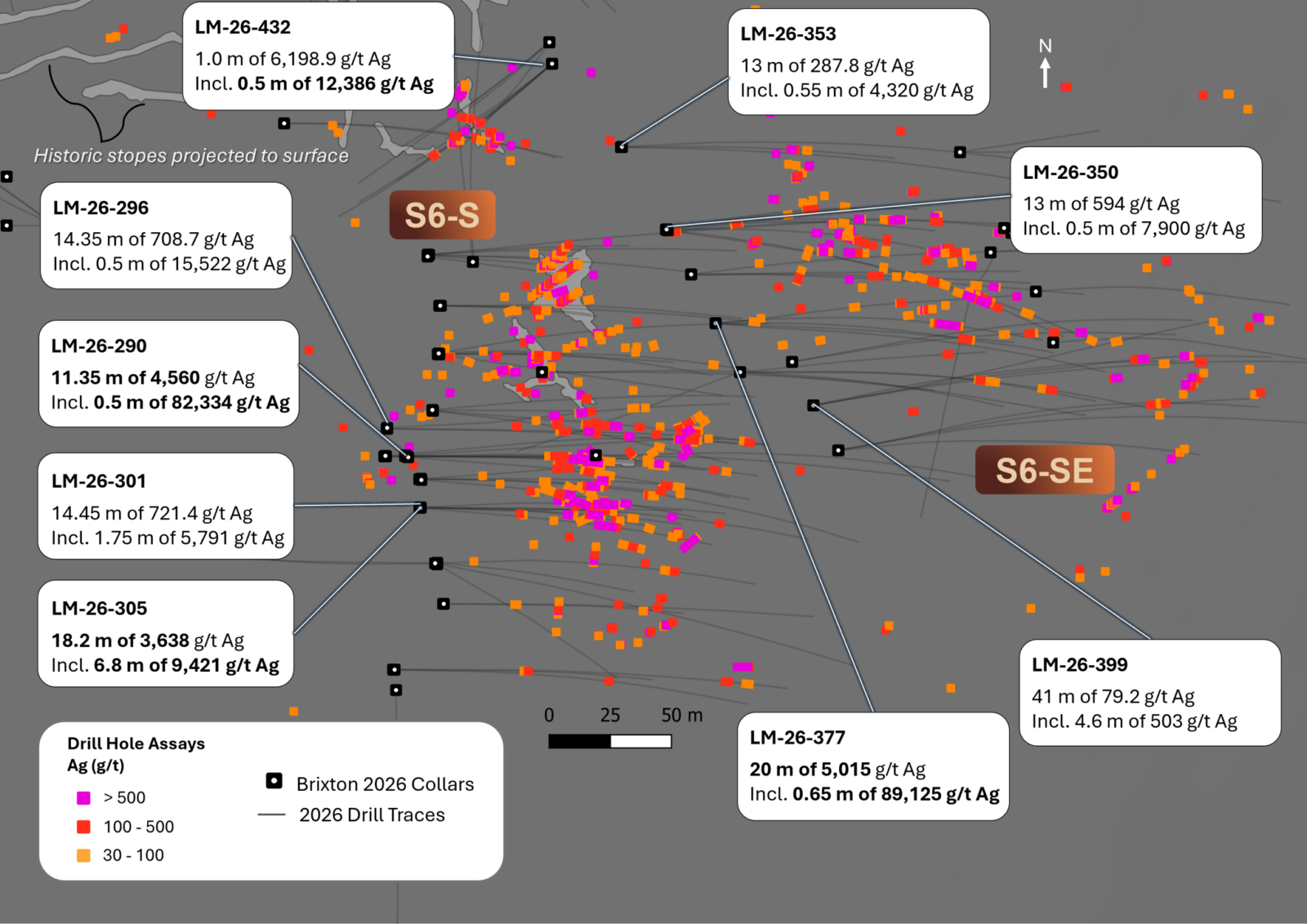
Table 4. Drill hole collar information for reported holes.
| Hole ID | Pad ID | Easting (m) |
Northing (m) |
Elevation (m) |
Azimuth | Dip | Depth (m) |
Zone | |
| LM-26-371 | LM-2026-022 | 607600 | 5270850 | 220.9 | 90 | -60 | 249.00 | S6-SE | |
| LM-26-374 | LM-2026-009 | 607280 | 5271020 | 215.7 | 130 | -58 | 219.00 | S6-N | |
| LM-26-375 | LM-2026-062 | 607500 | 5270780 | 217.3 | 90 | -55 | 249.00 | S6-SE | |
| LM-26-378 | LM-2026-008 | 607180 | 5271020 | 207.1 | 90 | -60 | 201.00 | S6-N | |
| LM-26-379 | LM-2026-062 | 607500 | 5270780 | 217.3 | 85 | -60 | 252.00 | S6-SE | |
| LM-26-381 | LM-2026-062 | 607500 | 5270780 | 217.3 | 95 | -60 | 249.00 | S6-SE | |
| LM-26-382 | LM-2026-008 | 607180 | 5271020 | 207.1 | 160 | -55 | 202.00 | S6-N | |
| LM-26-383 | LM-2026-062 | 607500 | 5270780 | 217.3 | 95 | -50 | 246.00 | S6-SE | |
| LM-26-384 | LM-2026-008 | 607180 | 5271020 | 207.1 | 270 | -55 | 201.00 | S6-N | |
| LM-26-385 | LM-2026-063 | 607510 | 5270760 | 216.9 | 90 | -55 | 300.00 | S6-SE | |
| LM-26-386 | LM-2026-008 | 607180 | 5271020 | 207.1 | 20 | -60 | 201.00 | S6-N | |
| LM-26-387 | LM-2026-063 | 607510 | 5270760 | 216.9 | 90 | -60 | 300.00 | S6-SE | |
| LM-26-388 | LM-2026-008 | 607180 | 5271020 | 207.1 | 20 | -50 | 219.00 | S6-N | |
| LM-26-389 | LM-2026-063 | 607510 | 5270760 | 216.9 | 95 | -55 | 261.00 | S6-SE | |
| LM-26-390 | LM-2026-020 | 607330 | 5271060 | 217.0 | 90 | -50 | 210.00 | S6-N | |
| LM-26-391 | LM-2026-063 | 607510 | 5270760 | 216.9 | 250 | -60 | 204.00 | S6-S | |
| LM-26-392 | LM-2026-020 | 607330 | 5271060 | 217.0 | 225 | -50 | 210.00 | S6-N | |
| LM-26-393 | LM-2026-063 | 607510 | 5270760 | 216.9 | 85 | -57 | 198.00 | S6-SE | |
| LM-26-394 | LM-2026-079 | 607324 | 5270862 | 215.0 | 90 | -58 | 201.00 | S6 | |
| LM-26-395 | LM-2026-070 | 607531 | 5270764 | 217.1 | 80 | -55 | 300.00 | S6-SE | |
| LM-26-396 | LM-2026-025 | 607324 | 5270862 | 213.2 | 90 | -60 | 216.00 | S6 | |
| LM-26-398 | LM-2026-082 | 607077 | 5270856 | 209.8 | 275 | -55 | 201.00 | S6-W | |
| LM-26-399 | LM-2026-082 | 607540 | 5270746 | 216.8 | 80 | -50 | 300.00 | S6-SE | |
| LM-26-400 | LM-2026-082 | 607077 | 5270856 | 209.8 | 275 | -60 | 123.00 | S6-W | |
| LM-26-401 | LM-2026-082 | 607077 | 5270856 | 209.8 | 290 | -45 | 180.00 | S6-W | |
| LM-26-402 | LM-2026-082 | 607077 | 5270856 | 209.8 | 275 | -45 | 219.00 | S6-W | |
| LM-26-403 | LM-2026-071 | 607541 | 5270746 | 216.9 | 80 | -55 | 300.00 | S6-SE | |
| LM-26-404 | LM-2026-082 | 607077 | 5270856 | 209.8 | 290 | -55 | 116.00 | S6-W | |
| LM-26-405 | LM-2026-039 | 607210 | 5270820 | 212.0 | 300 | -55 | 213.00 | S6 | |
| LM-26-406 | LM-2026-082 | 607077 | 5270856 | 209.8 | 290 | -60 | 165.00 | S6-W | |
| LM-26-407 | LM-2026-071 | 607541 | 5270746 | 216.9 | 80 | -45 | 321.00 | S6-SE | |
| LM-26-408 | LM-2026-039 | 607210 | 5270820 | 212.0 | 300 | -50 | 198.00 | S6 | |
| LM-26-432 | LM-2026-102 | 607433 | 5270886 | 218.8 | 230 | -66 | 199.00 | S6 | |
About the Langis Project
An Exploration Target of 1.0 to 2.0 million tonnes grading 400 to 800 g/t silver has been conceptualized for the project. Note: The potential quantity and grade of the Exploration Target are conceptual. Insufficient exploration has been completed to define a mineral resource, and there is no certainty that further exploration will result in the target being delineated as a mineral resource.
The wholly owned Langis Silver Project, located approximately 500 km north of Toronto, Ontario, Canada, includes a former producing mine and benefits from excellent infrastructure, including all-season road access, power, rail connections, and a refiner. Silver mineralization occurs as native silver and in steeply to moderately dipping veins, veinlets, disseminations, rosettes, and fracture infill, often associated with minerals such as calcite, hematite, pyrite, cobaltite, chalcopyrite, niccolite, and gold. Mineralization is hosted across three principal rock types: Archean Keewatin volcanic and metasedimentary rocks, Proterozoic Coleman Member sedimentary rocks of the Huronian Supergroup, and Proterozoic Nipissing diabase. The geological deposit model for the area is a continental-rift extensional depositional environment. The Langis Mine produced 10.4 million ounces of silver intermittently between 1908 and 1989 at a head grade of 20 to 25 opt, with reported recoveries of 88% to 98%. Previous operators developed over 10 km of underground workings; however, shafts and openings have been capped and sealed. Historically, reported silver mines in the Cobalt Camp have collectively produced over 445 million ounces of silver. We also understand, through personal communication with mine workers in the camp, that ultra-high-grade native silver collector pieces did not make it through the mills, suggesting that the camp’s actual silver production is significantly higher than the reported numbers. The historic production figures referenced above are sourced from third-party records and personal communications, have not been verified by Brixton or by the Qualified Person, and should not be relied upon.
Quality Assurance & Quality Control
Quality assurance and quality control protocols for drill core sampling were developed by Brixton. Core samples were mostly taken at 2.0 m intervals. High-grade intervals were taken at 0.50 m to 1.00 m intervals. Blanks, duplicates (lab pulp), and certified reference materials were inserted at a combined rate of up to 15%. Core samples were cut in half, bagged, zip-tied, and sent directly to the ALS Minerals preparation facility in Sudbury, Ontario. ALS Minerals Laboratories is registered to ISO 9001:2015 and ISO 17025 accreditations for laboratory procedures. Samples were analyzed at ALS Laboratory Facilities in North Vancouver, British Columbia, for gold by fire assay with an atomic absorption finish. Ag, Pb, Cu, and Zn, as well as 48 additional elements, were analyzed using a four-acid digestion with an ICP-MS finish. Overlimit silver samples were analyzed using fire assay and gravimetric finish, and/or fire assay and gravimetric finish on concentrates. The certified reference materials were acquired from CDN Resource Laboratories Ltd. of Langley, British Columbia, and the standards inserted varied with the type and abundance of mineralization observed in the primary sample. Blank material used consisted of non-mineralized siliceous landscaping rock. A copy of the QAQC protocols is available on the Company’s website.
Qualified Person
Mr. Gary Thompson, P.Geo., is the Chairman and CEO and a senior geologist for the Company who is a Qualified Person as defined by National Instrument 43-101. Mr. Thompson has verified the referenced data and analytical results disclosed in this press release and has approved the technical information presented herein.
About Brixton Metals Corporation
Brixton Metals is a Canadian exploration company focused on the advancement of its mining projects. Brixton wholly owns four exploration projects: Thorn copper-gold-silver-molybdenum Project in NW British Columbia, the Hog Heaven copper-gold-silver Project in NW Montana, USA, which is optioned to Ivanhoe Electric Inc., the Langis and Hudson Bay silver Projects in Ontario and the Atlin Goldfields Project located in northwest BC, which is optioned to Eldorado Gold Corporation.
Brutus Mining Inc. (CSE: BRU) (FSE: ZI3) is pleased to announce that it has closed its non-brokered ... READ MORE
Jaguar Uranium Corp. (NYSE American: JAGU) is pleased to announce an independent Mineral Resource E... READ MORE
Auro Metals Inc. (TSX-V: AURO) (OTCQB: AURFF), is pleased to announce the assay results of the fina... READ MORE
Endeavour Silver Corp. (NYSE: EXK) (TSX: EDR) is pleased to announce that repairs to the primary bal... READ MORE
Scorpio Gold Corp. (NASDAQ: SGLD) (TSX-V: SGLD) (OTCQB: SRCRF) (FSE: RY9) is pleased to announce re... READ MORE


