


Blue Star Gold Corp. (TSX-V: BAU) (OTCQB: BAUFF) (FSE: 5WP0) provides an update on the critical minerals component of its exploration program at the Ulu and Roma Projects in the Kitikmeot region of Nunavut.
Assay results are available for the first of five drill holes completed on the HI01 target on the Roma Project. This target is being renamed the Ataani Target; Ataani having the meaning of underneath/beneath in the local dialect. This name reflects the discovery of the massive sulphide lens below a flat lying diabase sill.
Highlights
Grant Ewing, CEO of Blue Star stated, “This is the first exploration program where we have focused on gold exploration and assessing some of our high priority critical mineral targets. Blue Star’s exploration team delivered an excellent result with the discovery of the Ataani massive sulphide lens with the first drill hole on the target. There is substantial potential for the discovery of additional near surface massive sulphide lenses in the immediate area as the gossan trends under a small lake to the south, and only ~20% of the HI01 property has been evaluated to date. Being proximal to the proposed Grays Bay Road (~6 km) and the High Lake VMS Deposit (~12 km) is another excellent attribute of the Ataani discovery.”
Discussion of results
An initial program of Fixed Loop Electromagnetic surveying was completed in the northern portion of the HI01 claim (Figure 1) resulting in a 320 metre by 100 metre EM plate representing a zone of strong conductivity located 180 metres below surface (Figure 2). A drill program of five holes for 1,365 metres was undertaken with the results of the first hole provided within this release and additional drill intervals discussed below; additional assay results are pending.
The initial drill hole targeting the Ataani Target (DD24-HII-001) was completed to a depth of 291 metres. Rock units encountered include an overlaying Proterozoic diabase sill, a late Archean granitoid unit, and a package of sericite-altered felsic tuffs hosting a seventeen (17.1) metre zone of stringer to massive sulphide mineralisation which returned a composite grade of 0.42% Cu, 1.43% Zn, 0.03% Pb, 9.19 g/t Ag, and 0.13 g/t Au (Table 1). Within the mineralised zone, a 2.0-metre interval of massive sphalerite and buckshot pyrite returned 10.95% Zn and a 3.5-metre interval of massive pyrrhotite with chalcopyrite graded 1.46% Cu. This mineralised section is co-incident with the modeled strong conductor.
DD24-HII-002 was drilled down dip of the mineralized zone intersected in HII-001, targeting ~45 metres below and just outside the Maxwell plate. This drillhole completed to a depth of 279 metres encountered the overlaying Proterozoic diabase sill, a late Archean granitoid unit, and a package of sericite-altered felsic tuffs hosting a thirty-seven (37.25) metre zone of stringer to massive sulphide mineralisation. Within the mineralised zone, a 3.45 metre and a 1.3 metre interval of massive pyrrhotite with up to 3% visible chalcopyrite occurs. This mineralised zone is co-incident with the down dip extension of the modeled strong conductor.
DD24-HII-003 was drilled ~50 metres down dip of the 37.25 metre mineralized zone intersected in DD24-HII-002. This drill hole encountered the same package of rocks as the previous two drill holes including a thick 83 metre package of sericite altered felsic volcanic rocks. A 1.29 metre interval of massive sulphide with predominantly pyrite was encountered at a depth of 288.65 metres downhole.
DD24-HII-004 stepped 115 metres south of the DD24-HII-001, 002 and 003 drill section and again intersected similar geology found in the first three drill holes. Below the granite at 167 metres downhole, a package of felsic volcanic rocks was host to several short intervals of stringer to massive sulphide up to 6.37 metres in width. Sulphides include both pyrite and pyrrhotite with minor chalcopyrite.
DD24-HII-005 was drilled 110 metres north of the DD24-HII-001, 002 and 003 drill section to test the northern extent of the conductive zone identified by the EM program. This hole intersected the overlying Proterozoic diabase sill, the late Archean granitoid and a felsic tuff package at a depth of 240 metres downhole. Sulphides encountered include a 5.01 metre interval of disseminated to massive pyrite and pyrrhotite. Minor chalcopyrite was identified in the mineralized zone.
Exploration Program Progress and Next Steps
The field components of the program are complete with final camp demobilisation planned to occur in September. Assay results are being reviewed and interpreted as received for timely disclosure.
After receipt of all assay data from the current program, deposit modeling will be conducted with the compiled field data and results to determine impacts to the resource base, pipeline target prioritisation and pre-planning for 2025. Incremental work this season is expected to lead to future discoveries to grow our resource base of both gold and base metals across the Ulu Project and Roma Project in the Kitikmeot Region of Nunavut.
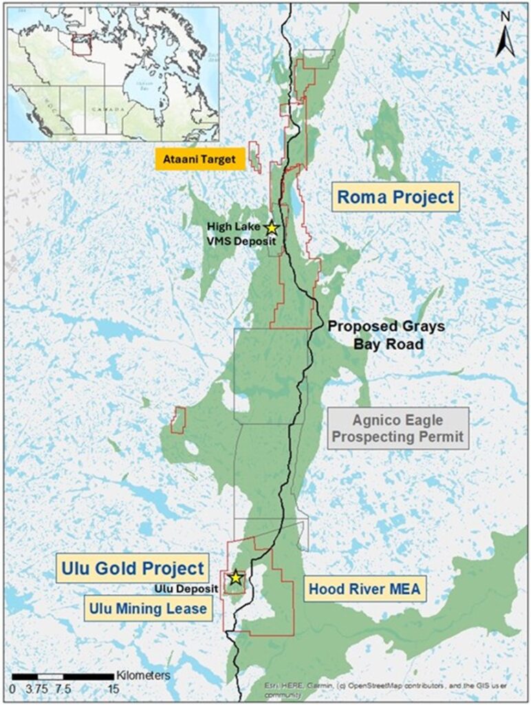
Figure 1: Blue Stars Landholdings, Showing Ataani Target Location and Proposed Grays Bay Road.
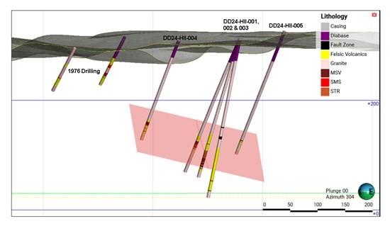
Figure 2: Oblique Section Looking ~West-northwest Showing Modelled Conductive Plate and Drill Traces with Geology of the Ataani Target.
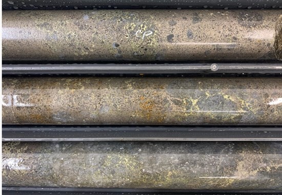
Figure 3: Photo Showing Massive Pyrrhotite & Chalcopyrite with Siliceous Clasts from DD24-HII-002 which Intersected a 37.25 Metre Mineralized Zone.
Table 1: Drill results for DD24-HII-001
| HoleID | From(m) | To(m) | Length(m) | Cu % | Zn % | Pb % | Ag g/t | Au g/t |
| DD24-HII-001 | 222.7 | 239.8 | 17.1 | 0.42 | 1.43 | 0.03 | 9.19 | 0.13 |
| Including | ||||||||
| DD24-HII-001 | 228.3 | 230.3 | 2.0 | 0.08 | 10.95 | 0.11 | 4.33 | 0.12 |
| DD24-HII-001 | 236.3 | 239.8 | 3.5 | 1.46 | 0.15 | 0.01 | 25.68 | 0.29 |
*All intervals are core lengths; insufficient drilling has been completed to determine true widths; assays are uncapped.
Drill samples are one half from sawn NQ sized drill core delivered under chain of custody to ALS Geochemistry in Yellowknife, NT for sample preparation which are then forwarded to ALS Canada Inc. in North Vancouver, BC for final analysis. Samples are prepared using code PREP-31 (crushing and pulverising) and analysed using codes Au-AA26 (50-gram fire assay with atomic absorption finish) and ME-MS61 (48 element four acid digestion with ICP-MS finish). Over limits for non-gold elements are ore grade four acid digestion with ICP-AES finish. The QAQC program for drilling consists of regular insertion of certified reference materials (CRMs) resulting in a 10% insertion rate.
Metal Equivalents:
Copper Equivalent (CuEq) and Gold Equivalent (AuEq) mentioned above for drill intersections are calculated on a basis of US$ 3.75/lb for Cu, US$ 1,900/oz for Au, US$ 20/oz for Ag, US$ 1/lb for Zn, and US$ 0.95/lb for Pb with metallurgical recoveries for all metals from the recoveries used in the MMG 2023 Mineral Resource and Ore Reserves Statement. The assays have not been capped. Calculations reviewed with Equivalent Grade Calculator (aaronmcm.com).
Darren Lindsay, P. Geo. and Vice President Exploration for Blue Star, is a Qualified Person under National Instrument 43-101 (“NI 43-101”) and has reviewed and approved the technical information contained in this news release.
Gray’s Bay Road and Port Project (GBRPP)
West Kitikmeot Resources is the new proponent for the GBRPP. The project envisions a deepwater port built on the Coronation Gulf, and a road connecting Nunavut to the Northwest Territories. Approximately $22 million in federal funding is on hand to advance the GBRPP Phase 1 to shovel-ready status.
The proposed all-season road would travel within and immediately adjacent to Blue Star’s Projects, providing excellent accessibility. This future access will dramatically lower the cost of doing business in the region, connecting Northern products to markets around the world, and enabling supplies to reach the area at a lower cost, for a longer season, and with greater reliability.
About Blue Star Gold Corp.
Blue Star is a mineral exploration and development company focused in Nunavut, Canada. Blue Star’s landholdings total 270 square kilometres of highly prospective and underexplored mineral properties in the High Lake Greenstone Belt. The Company owns the Ulu Gold Project, comprised of the Ulu Mining Lease and Hood River Property, and the Roma Project. A significant high-grade gold resource exists at the Flood Zone deposit (Ulu Mining Lease), and numerous high-potential exploration targets (gold and critical minerals) occur throughout the Company’s extensive landholdings, providing Blue Star with excellent resource growth potential. The site of the future deep-water port at Grays Bay is 40 – 100 km to the north of the properties, and the proposed route corridor for the all-weather Grays Bay Road passes close by the Roma and Ulu Gold Projects.
Acquisition Adds Indicated Gold Resources of 388koz and Inferred ... READ MORE
Highlights • Hole 26MN-069 returned: o 0.62 g/t gold over 62.21... READ MORE
“Wheaton delivered a strong start to 2026, with Salobo and... READ MORE
VIOR GOLD CORPORATION INC. (TSX-V: VIO) (OTCQB: VIORF) (FRA: VL5)... READ MORE
Gravity-Finish Re-Assay Confirms High-Grade Gold Mineralization a... READ MORE


