


Blue Star Gold Corp. (TSX-V: BAU) (FSE: 5WP0) (OTCQB: BAUFF) announces additional results from its 2022 exploration program across the Company’s highly prospective Ulu, Hood River, and Roma projects located in the Kitikmeot Region of Nunavut.
Program Highlights:
Exploration Program Summary
All drilling was completed with oriented core to assist in geological modeling. In addition, 58 of the >100 showings in the ‘target pipeline’ were reviewed, prospected, and mapped. Approximately 50% of the program samples are pending laboratory results, most of which are rock and soil samples.
Discussion of Drill Results Reported:
The Central Zone target area is comprised of three inferred sub-parallel calc-silicate altered and locally mineralised structures traced intermittently on surface for up to 2,000 metres. One zone, Central-C, was chosen for additional drilling this season due to its proximity to the Flood Zone, the strong alteration present, and the down dip continuity determined from previous drilling. Drilling indicates a potential change in orientation of the structure parallel to the Flood Zone, a more favourable orientation for mineral development.
A final drill hole at the Gnu (Nutaaq) Zone, DD22-IGU-001A is reported that was evaluating a blind vein intersected in DD22-MIQ-001 earlier in the season which returned 0.68 m of 1.06 g/t gold.
DRILLING
DD22-CEN-001 returned no significant intercepts although the target was intersected as an 11-metre-wide section of calc-silicate alteration with intervals of silicification and low abundances of acicular arsenopyrite. The drillhole cut a series of basalt flows with a significant fault that was logged above the target horizon.
DD22-CEN-002, returned an open 40.24 m wide moderately to strongly altered interval containing 0.73 g/t gold starting at 126.76 metres downhole, including 2.49 m of 2.70 g/t gold and 5.42 m of 1.35 g/t gold. The drill hole intersected basalt flows with an interval of interflow sediment located between 105.48 to 109.76 m. Two sections of weak irregular calc-silicate alteration were logged, with both returning anomalous levels of gold mineralisation associated with sections of stronger alteration, silicification and abundances of fine acicular arsenopyrite up to 2-3%.
DD22-CEN-003 intersected 4.24 g/t gold over 2.5 m, including 5.59 g/t over 1.59 m starting at 112.29 m downhole. The hole was drilled through basalt flows and gabbro. A 6 cm wide interval of strong fault gouge was noted in the drillhole at approximately 52 m. The targeted acicular arsenopyrite zone (107 – 115 m) contains two sections of strongly strained, altered and silicified basalt hosting pyrite and pyrrhotite and 1% acicular arsenopyrite at the start of the interval and up to 7% acicular arsenopyrite in the lower portion of the interval, which returned the best gold values.
DD22-CEN-004 was drilled to test a historical drill hole (90VD83; 1.09 m of 27.49 g/t gold). The hole intersected basalt flows and two quartz-feldspar porphyry dikes. Two fault gouge zones were also intersected. Two intercepts of interest, 0.39 m of 1.31 g/t gold and 0.99 m of 1.26 g/t gold, are associated with silicified sections of calc-silicate altered rock with trace to 2% pyrite and pyrrhotite and small clusters of fine acicular arsenopyrite.
DD22-IGU-001/-001A. The initial drill hole was lost and was redrilled. The hole intercepted gabbro hosting a smoky quartz vein. The vein contained pyrrhotite, sphalerite, pyrite, chalcopyrite and rare visible gold mineralisation. The host rock contained leucoxene alteration and exhibited moderate to strong strain around the veining.
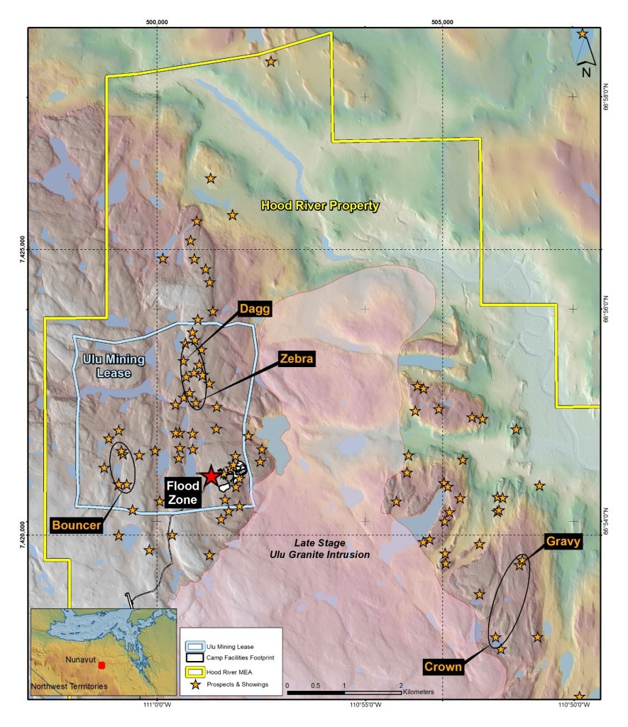
Figure 1: Target pipeline plan map
Table 1: Table of drill collar locations for holes reported in this release
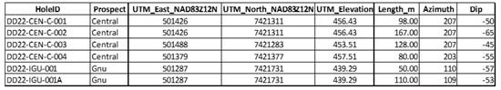
Table 2: Table of results to date

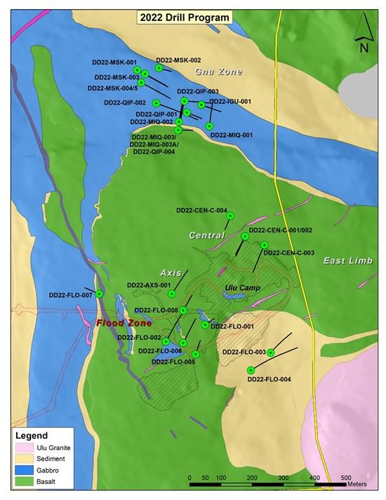
Figure 2: Plan map of drill holes
Blue Star Gold’s Projects
The Company’s properties are located approximately 525 km NNE of Yellowknife, NT in the Kitikmeot region of western Nunavut. The hamlet of Kugluktuk is approximately 210 km to the NW. The Roma property lies approximately 30 km north of the Ulu-Hood River property. The total area of Blue Star’s projects encompasses 267 km2 of the highly prospective and underexplored High Lake Greenstone Belt.
The Ulu lease and the contiguous Hood River property together encompass greater than 12,000 hectares (120 km2) of highly prospective exploration ground. The recent acquisition of the prospective and underexplored Roma property that lies approximately 30 km north increased the Company’s landholdings by more than 14,000 hectares (140 km2) in the High Lake Greenstone Belt.
The Ulu mining lease hosts the advanced stage Flood Zone gold deposit, where a significant high-grade gold resource has been outlined. Several additional gold prospects (including, but not limited to, Zebra, Contact, Central, Axis, and Gnu) are spatially related to the axis of the 5 km long Ulu Fold, which extends from the Ulu lease onto the northern part of the Hood River property and culminates at the North Fold Nose Zone. The recent expansion of the Hood River concession added several new target zones south of the Flood Zone gold deposit. The eastern side of the Hood River property is contiguous to the Ulu lease, and hosts over twenty known gold showings. The Hood River prospects have the same deformation history (including tight folding) as well as similar mineralization styles (acicular arsenopyrite and polymetallic quartz veins) and stratigraphic sequences as the Flood Zone. One of the most prospective target areas on the eastern Hood River property is the 4 km long Crown-Pro trend which has seen only limited drilling.
The Roma project lies in the northern section of the High Lake Greenstone Belt. The project covers high grade gold showings discovered by previous explorers, notably BHP Minerals from 1988 to 1994. Multiple significant gold showings are present within a 6.5 km x 2.4 km area on the historic Roma claim block. The original showing is a 0.30 to 3.0 m wide quartz vein exposed in outcrop and boulders for 2.0 km. In 1991, BHP drilled 10 shallow holes totalling 465 metres to test 1.72 km of strike of the vein. All drill holes intersected quartz veins from 15 m to 37 m vertically below surface. Visible gold was noted in three of the drillholes and the best results were 12.38 g/t Au over 2.31 m (including 64.0 g/t Au over 0.37 m) from DDH MD-01, and 8.69 g/t Au over 1.87 m from MD-03. No drilling was conducted downdip of the high-grade intersection in DDH MD-01 and no step out drilling to the north from this intercept was conducted. No follow up drilling is known to have been completed on this property since BHP’s initial drill program in the 1990’s. The Company has not verified the historical results from the Roma property and has presented information obtained from two assessment reports submitted by BHP Minerals Canada Ltd.; McMaster, G., (1995). Roma 3,4,5 and 6 Claims 1995 Geological and Geochemical Report, and Anonby, L. and Jopson, W., (1992). Geological, Geochemical, Geophysical and Drilling Report on the Roma 1 and 2 Claims.
The site of the future deep-water port at Gray’s Bay is 40 – 100 km to the north of the properties, and the proposed route corridor for the all-weather Gray’s Bay Road passes in close proximity to the Roma, Ulu, and Hood River projects.
Technical Disclosure
Drill holes reported had core samples cut by core saw with one half of the core retained and the other half sent for analysis. Samples were prepared by ALS Yellowknife-Geochemistry and analyzed at ALS Global, North Vancouver. Gold analysis was by fire assay using ALS code Au-AA26 and multielement analysis by code ME-MS61. Control samples include a crush duplicate every twenty samples; certified reference material was inserted once every ten samples. Reported assay intervals are uncapped, use a minimum 1 g/t gold assay cut off with the inclusion of up to 2 m of material below cut-off. True widths for all but the Flood Zone are not known due to lack of drilling and may range from 50% to 95% of drilled lengths.
Qualified Person
Darren Lindsay, P. Geo. and Vice President Exploration for Blue Star, is a Qualified Person under National Instrument 43-101 (“NI 43-101”) and has reviewed and approved the technical information contained in this news release.
About Blue Star Gold Corp.
Blue Star is a gold company focused on exploration and development within Nunavut, Canada. Blue Stars landholdings total approximately 270 square kilometres of highly prospective and underexplored mineral properties in the High Lake Greenstone Belt, Nunavut. The Company owns the Ulu Gold Property mining lease, an advanced gold project, the highly prospective Hood River Property that is contiguous to the Ulu lease, and the Roma Project. A significant high-grade gold resource exists at the Flood Zone deposit (Ulu lease), and numerous high-grade gold occurrences and priority targets occur throughout the Ulu, Hood River and Roma Projects.
Aura Minerals Inc. (NASDAQ: AUGO) (B3: AURA33) is pleased to anno... READ MORE
GR Silver Mining Ltd. (TSX-V: GRSL) (OTCQX: GRSLF) (FRANKF... READ MORE
Empress Royalty Corp. (TSX-V: EMPR | OTCQX: EMPYF) is pleased to ... READ MORE
JZR Gold Inc. (TSX-V: JZR) (OTCPK: JZRIF) is pleased to announce ... READ MORE
Colibri Resource Corporation (TSX-V: CBI) is pleased to announce ... READ MORE


