


Blue Star Gold Corp. (TSX-V: BAU) (FSE: 5WP) announces the final assay results from the 2020 exploration program at its Ulu and Hood River properties. The properties are located approximately 525 km NNE of Yellowknife, NT in the Kitikmeot region of western Nunavut. Kugluktuk is approximately 210 km to the NW.
Highlights:
Next Steps, Upcoming Milestones:
Ulu and Hood River Properties Overview:
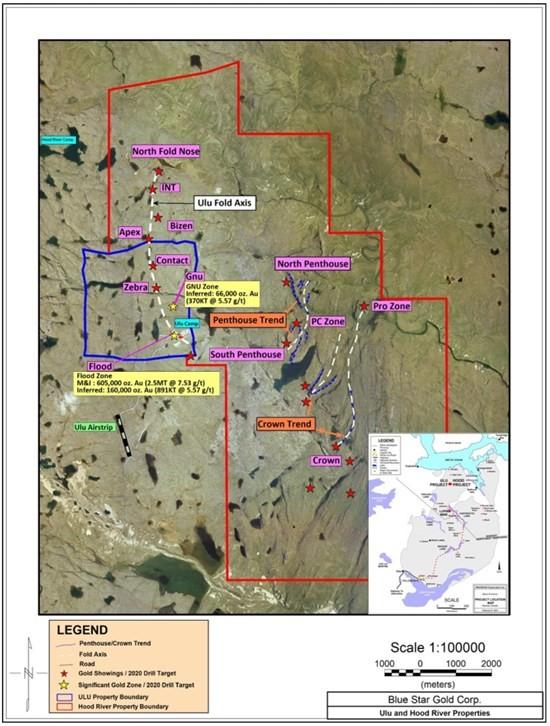
The Ulu lease and the contiguous Hood River property together encompass approximately 9,000 hectares of highly prospective exploration ground. The Ulu lease hosts the advanced stage Flood and Gnu Zone gold deposits, where a significant high-grade gold resource has been outlined. Several additional gold zones (including NFN, Zebra, Bizen, Apex and Contact Zones) are spatially related to the axis of the ~5 km long Ulu regional fold which extends from the Ulu lease onto the north Hood River property (see Figure 1). The Hood River property is contiguous to the Ulu lease to the north, east and south, and hosts over twenty known gold showings (see Figure 1). Many of the high-priority target areas outside of the Flood Zone have only been tested with relatively shallow drilling, and the potential throughout the properties to host new discoveries at depth is considered high.
2020 Exploration Program Summary Highlights:
The 2020 exploration program entailed 7,621 metres of diamond drilling in thirty-eight diamond drill holes on the Ulu and Hood River properties. Below is an overall summary of the program, including diamond drill holes that were reported in previous news releases (see news releases dated September 30 and October 28, 2020).
Ulu Lease:
The 2020 drill program at the Flood Zone comprised six drill holes (BS2020-ULU-001 to BS2020-ULU-006). The purpose of the drilling was to provide additional geologic information and confirm certain aspects of the geologic model of the deposits, to improve drill hole density and to allow for possible upgrading of the resource category. Drill hole BS2020-ULU-005 (reported today) tested inferred resource blocks at a vertical depth of approximately 400 metres. The hole intercepted a series of mineralized zones from a downhole depth of 425.0m to 469.0m including 14.95 g/t Au over 13.80m (426.20 – 440.0m) and 9.65 g/t Au over 6.0m (459.0 – 465.0m). The azimuth and dip of the hole at this intercept point is approximately 242 and -62 degrees respectively. Mineralization occurs as fine to coarse grained disseminated arsenopyrite along with fine grained pyrrhotite, pyrite and chalcopyrite associated with smoky quartz veins within a calc-silicate alteration envelope. Previous modelling indicates that the Flood Zone is near vertical in the area of BS2020-ULU-005’s intercepts. The results of this hole potentially allows for an improvement in the resource grade and a change of the resource category from inferred to indicated status in this area. Holes BS2020-ULU-001 to 004 and 006 were reported previously (see news releases dated September 30 and October 28, 2020).
The Gnu Zone, which is 700m north of the Flood Zone, can be traced over approximately 625 metres in a NW-SE direction. Mineralization typically occurs as finely disseminated acicular arsenopyrite associated with pervasive calc-silicate alteration, similar to that found in the Flood Zone. Polymetallic quartz veins are also present in the Gnu Zone. The high grade gold mineralization intersected in BS2020ULU-007 (52.7 g/t Au over 2m, see news release dated October 28, 2020) has a polymetallic signature with highs of 0.8% Pb, 0.7% Zn, 57.5 ppm Ag and anomalous bismuth. BS2020ULU-007 was collared 30m east of historic hole 92VD161 (14.7 g/t Au over 3.22m from a polymetallic quartz vein). Subsequent drill holes BS2020ULU-008 through BS2020ULU-010, which were drilled in the vicinity of BS2020ULU-007 and 92VD161, did not intersect significant gold values. The geometries of the different styles of mineralization present have not yet been resolved with the limited amount of drilling (20 holes totalling 2,167m) completed to date. The geologic model for the Gnu Zone is planned to be updated as part of the property wide data assessment and compilation program underway.
At the Contact Zone, which is approximately 1.8 km north of the Flood Zone, mineralization occurs in quartz veins and stockworks, and sulphide replacement zones. The vein-type is associated with haloes of pervasive sericite ±silica altered basalt with pyrrhotite, arsenopyrite, pyrite and arsenopyrite. The best mineralization intersected in the two holes drilled in 2020 was 3.96 g/t Au over 1.0m in hole BS2020ULU-011.
Hood River North:
The 2020 drill program tested targets along the east limb of the Ulu anticline including the NFN, INT, Bizen, and Apex Zones. The fold limb is expressed as a topographic break coincident with the steeply east dipping contact between basaltic volcanic and biotite-cordierite metasedimentary rocks.
At the NFN Zone, fourteen drill holes (HR20-13 to HR20-26) were drilled in an area 215 metres long by 100 metres wide to a maximum depth of 180 metres from surface. The NFN Zone is a south dipping synform with mineralization focused along a shear zone dividing basaltic volcanics and biotite-cordierite schists. Anomalous gold values occur in quartz-carbonate-sericite-pyrrhotite-arsenopyrite-chalcopyrite shear vein fillings. An envelope of biotite and calc-silicate alteration extends tens of metres into the hanging wall basalts. All the holes drilled at the NFN intersected the targeted structure and 12 out of 14 returned significant gold grades. The mineralized intervals were typically between 2 and 4 metres wide. Higher grade intercepts included 13.87 g/t Au over 3.00m (HR20-17) and 13.18 g/t Au over 2.00m (HR20-13). Only 2 drill holes (HR20-19 and HR20-26) failed to return anomalous gold values. These two holes tested the northwestern and southern boundaries of drill coverage and intersected the targeted contact, however, only moderate silicification and traces of arsenopyrite was observed. It is expected that the results of the 2020 exploration program will provide enough data to complete the first resource estimate for this Zone (see news releases dated September 30 and October 28, 2020 for additional results).
The INT Zone is located between the NFN and Bizen Zones along the east limb of the Ulu anticline. Channel sampling conducted in 2019 resulted in one sample grading 25 g/t Au (Y622120). Follow up drilling in 2020 included two drill holes, HR20-27 and HR20-28. A one metre interval of anomalous gold in HR20-27 occurs in a shear zone containing medium grained pyrrhotite and pyrite altered with patchy actinolite and biotite.
One hole at the Bizen Zone (Hole HR20-29) was drilled to test for mineralization near the contact between mafic volcanics and metasediments. Gold-bearing mineralization is hosted in a unit of basaltic tuffaceous metagreywacke. Anomalous gold values are localized to thin, typically less than 10 cm, quartz-calc-silicate veins with medium-course grained pyrrhotite, chalcopyrite and arsenopyrite. Patchy biotite alteration extends several metres outward from and is overprinted by sericite proximal to the gold-bearing veins.
The Apex Zone is located 350 – 700 metres north of the Contact Zone. It is characterized by two zones of discontinuous gossans that merge toward the north. Mineralization occurs as quartz veins associated with biotite ±silica alteration and enriched in biotite, chlorite and minor actinolite. Mineralization encountered during the current program was generally weak and consisted of minor pyrite and arsenopyrite in narrow stringers that tend to parallel the regional, north-south oriented structure. Three diamond drill holes were completed in the area during the program to test sulphide bearing calc silicates and to improve the geological knowledge on the target. The highest-grade gold mineralization was intersected in HR20-032 (3.53 g/t Au over 2.00m).
Hood River East:
The Hood River East property holes were designed to test early-stage targets throughout the highly prospective property. The promise of the Hood River East ground stems from the fact that it shares the same deformation history (including tight folding) and the same volcano-sedimentary stratigraphic sequences as the Flood Zone.
At the Crown showing, mineralization occurs as quartz veins and sulphide replacement zones and stockworks. The veins are associated with haloes of pervasive biotite ±silica alteration and contain sulphides (predominantly pyrrhotite with minor amounts of pyrite and arsenopyrite). The basalt is moderately to strongly altered. Three diamond drill holes were completed to test mineralization near the volcanic and metasediments contact. The highest-grade gold mineralization was intersected in HR20-033 (2.33 g/t Au over 2.00m). The prospective trace of the north trending fold axis, which links the Crown showing to the Pro Zone 4 km to the north, remains untested.
At the PC showing in the Penthouse Lake area, mineralization occurs in sediment-hosted polymetallic quartz veins within massive sulphide lenses proximal to a mafic volcanic-sediment contact. Three diamond drill holes were completed here. The highest-grade gold assay of 2.53 g/t Au over 0.95m (HR20-038 20.0 to 20.95m) was returned from a zone of massive sulphides with quartz veining. Base metal values in this zone included highs of 9.6% Zn, 0.4% Cu and 0.9% Pb over 0.55m (20.95 to 21.50m).
Table 1. Ulu Property Gold Assay Results Reported:
| Hole ID | From (m) | To (m) | Width m | Au (g/t) | Comments |
| BS2020ULU-005 | 426.2 | 440 | 13.8 | 14.95 | upper zone |
| AND | 446 | 449 | 3 | 11.57 | |
| AND | 453 | 455 | 2 | 9.26 | |
| AND | 459 | 465 | 6 | 9.65 | lower zone |
| BS2020ULU-008 | NSV | No Significant Value | |||
| BS2020ULU-009 | NSV | No Significant Value | |||
| BS2020ULU-010 | NSV | No Significant Value | |||
| BS2020ULU-011 | 53 | 54 | 1 | 3.96 |
Table 2. Hood River Property Gold Assay Results Reported:
| Hole ID | From (m) | To (m) | Core Length (m) | Au (g/t) | Comment |
| HR20-021** | 141.5 | 143 | 1.5 | 6.39 | |
| incl | 142.1 | 143 | 0.9 | 8.70 | |
| HR20-026 | NSV | No Significant Value | |||
| HR20-029 | 156 | 157 | 1 | 1.37 | |
| AND | 164 | 165 | 1 | 2.73 | |
| HR20-030 | NSV | No Significant Value | |||
| HR20-031 | 95 | 96 | 1 | 1.43 | |
| HR20-032 | 34 | 36 | 2 | 3.53 | |
| HR20-033 | 12 | 14 | 2 | 1.15 | |
| AND | 36 | 38 | 2 | 2.33 | |
| incl | 36 | 37 | 1 | 3.02 | |
| HR20-034 | NSV | No Significant Value | |||
| HR20-035 | 9 | 10 | 1 | 3.7 | |
| HR20-036 | 23 | 24 | 1 | 1.14 | |
| HR20-037 | 10 | 11 | 1 | 1.24 | |
| AND | 17 | 21 | 4 | 1.37 | |
| HR20-038 | 16 | 17 | 1 | 1.23 | |
| AND | 20 | 20.95 | 0.95 | 2.53 |
* Intervals listed in the above tables are core length, and not true width. All assay values are uncut. ** These intervals were reported with results from HR20-022 in the news release dated Sept. 30, 2020.
Table 3. Highlight Gold Composites from 2020 Program on Ulu and Hood River Properties:
| Hole ID | Zone or Target | From(m) | To(m) | Width (m) | Au (g/t) |
| BS2020ULU-002 | Flood | 9 | 16 | 7 | 13.42 |
| BS2020ULU-003 | Flood | 13 | 22 | 9 | 8.67 |
| “ | Flood | 110 | 118 | 8 | 8.26 |
| “ | Flood | 160 | 164 | 4 | 8.17 |
| BS2020ULU-005 | Flood | 426.2 | 440 | 13.8 | 14.95 |
| Flood | 459 | 465 | 6 | 9.65 | |
| BS2020ULU-006 | Flood | 407 | 411 | 4 | 12.5 |
| “ | Flood | 432 | 436 | 4 | 9.98 |
| “ | Flood | 487 | 501 | 14 | 4.23 |
| “ | Flood | 504 | 511 | 7 | 12.5 |
| BS2020ULU-007 | Gnu | 25 | 27 | 2 | 52.7 |
| HR20-013 | NFN | 109 | 111 | 2 | 13.18 |
| HR20-014 | NFN | 118 | 122 | 4 | 7.59 |
| HR20-016 | NFN | 143 | 145 | 2 | 10.85 |
| HR20-017 | NFN | 164 | 167 | 3 | 13.87 |
* Composite intervals listed in the above table are core length, and not true width. All assay values are uncut.
Table 4: Ulu Project Diamond Drill Hole Summary:
| Hole Name | Project Name | Target Name | Azimuth | Dip | Total Metres Drilled |
| BS2020ULU-001 | ULU PROJECT | FLOOD | 17 | -65 | 400 |
| BS2020ULU-002 | ULU PROJECT | FLOOD | 270 | -50 | 17 |
| BS2020ULU-003 | ULU PROJECT | FLOOD | 270 | -55 | 350 |
| BS2020ULU-004 | ULU PROJECT | FLOOD | 205 | -62 | 641 |
| BS2020ULU-005 | ULU PROJECT | FLOOD | 230 | -57 | 536 |
| BS2020ULU-006 | ULU PROJECT | FLOOD | 216 | -61 | 542 |
| BS2020ULU-007 | ULU PROJECT | GNU | 27 | -50 | 170 |
| BS2020ULU-008 | ULU PROJECT | GNU | 27 | -65 | 101 |
| BS2020ULU-009 | ULU PROJECT | GNU | 27 | -45 | 130.5 |
| BS2020ULU-010 | ULU PROJECT | GNU | 27 | -60 | 142 |
| BS2020ULU-011 | ULU PROJECT | CONTACT | 234 | -55 | 284 |
| BS2020ULU-012 | ULU PROJECT | CONTACT | 275 | -50 | 383 |
| Total | 3696.5 m |
Table 5: Hood River Project Diamond Drill Hole Summary:
| Hole Name | Project Name | Target Name | Azimuth | Dip | Total Metres Drilled |
| HR20-013 | HOOD RIVER PROJECT | NFN | 40 | -55 | 126 |
| HR20-014 | HOOD RIVER PROJECT | NFN | 40 | -73 | 151 |
| HR20-015 | HOOD RIVER PROJECT | NFN | 240 | -79 | 181 |
| HR20-016 | HOOD RIVER PROJECT | NFN | 240 | -58 | 210.5 |
| HR20-017 | HOOD RIVER PROJECT | NFN | 240 | -45 | 215 |
| HR20-018 | HOOD RIVER PROJECT | NFN | 67 | -86 | 211 |
| HR20-019 | HOOD RIVER PROJECT | NFN | 67 | -73 | 164 |
| HR20-020 | HOOD RIVER PROJECT | NFN | 67 | -55 | 154 |
| HR20-021 | HOOD RIVER PROJECT | NFN | 67 | -76 | 148 |
| HR20-022 | HOOD RIVER PROJECT | NFN | 67 | -88 | 163 |
| HR20-023 | HOOD RIVER PROJECT | NFN | 67 | -85 | 109 |
| HR20-024 | HOOD RIVER PROJECT | NFN | 40 | -60 | 120.5 |
| HR20-025 | HOOD RIVER PROJECT | NFN | 246 | -70 | 101 |
| HR20-026 | HOOD RIVER PROJECT | NFN | 245 | -48 | 133 |
| HR20-027 | HOOD RIVER PROJECT | INT | 356 | -45 | 100 |
| HR20-028 | HOOD RIVER PROJECT | INT | 356 | -70 | 145 |
| HR20-029 | HOOD RIVER PROJECT | BIZEN | 90 | -45 | 314 |
| HR20-030 | HOOD RIVER PROJECT | APEX | 290 | -45 | 300.7 |
| HR20-031 | HOOD RIVER PROJECT | APEX | 180 | -45 | 161 |
| HR20-032 | HOOD RIVER PROJECT | APEX | 180 | -75 | 111.5 |
| HR20-033 | HOOD RIVER PROJECT | CROWN | 45 | -45 | 149 |
| HR20-034 | HOOD RIVER PROJECT | CROWN | 45 | -85 | 89 |
| HR20-035 | HOOD RIVER PROJECT | CROWN | 290 | -55 | 152 |
| HR20-036 | HOOD RIVER PROJECT | SOUTH PENTHOUSE | 15 | -60 | 107 |
| HR20-037 | HOOD RIVER PROJECT | SOUTH PENTHOUSE | 15 | -87 | 46 |
| HR20-038 | HOOD RIVER PROJECT | SOUTH PENTHOUSE | 1 | -70 | 62 |
| Total | 3924.2 m |
Figure 1. Ulu and Hood River Properties
QA/QC Program for the 2020 Exploration Work:
All drill core was logged and sampled in secure core processing structures located at the Ulu or Hood River camps. Drill core samples were collected by either cutting the core in half using diamond saws or by splitting the core in half using hydraulic core splitters. In addition to the QA/QC protocols of ALS Global, the Company maintains its own program of inserting Standard Reference material in the form of standards and blanks into the sampling stream, prior to being shipped to ALS’s preparation facility in Yellowknife.
History and Geology of the Ulu and Hood River Gold Properties:
The properties are located approximately 525 km NNE of Yellowknife, NT in the Kitikmeot region of western Nunavut. Kugluktuk is approximately 210 km to the NW.
The Ulu property consists of a renewable 21-year mining lease and covers an area of approximately 947 ha. The lease hosts an advanced gold project that between 1989 and 2012 saw significant exploration and development by BHP Minerals and Echo Bay Mines, among others. The past work includes approximately 1.7 km of underground development and approximately 405 diamond drill holes that produced 97,820 m of core (Ulu and Hood River). The Flood Zone contains the bulk of the Ulu gold resource and is open on-strike and at depth. Overall resources of 2.50 million tonnes grading 7.53 g/t Au for 605,000 gold ounces (measured & indicated category) and 1.26 million tonnes grading 5.57 g/t Au for 226,000 gold ounces (inferred category) have been estimated for the Flood and Gnu Zones (refer to “Technical Report on the Ulu Gold Property, Nunavut, Canada” dated July 10, 2015). The deepest intersection of mineable width at the Flood Zone is 14.9 g/t Au over 7.7 m in BHP’s drill hole 90VD-75 at 610 m below surface. Metallurgical testing on the Flood Zone gold mineralization has shown that gold is recoverable in amounts greater than 90% by gravity, flotation and cyanidation.
The Hood River property is contiguous to the Ulu lease to the north, east and south. The property is held through a renewable, 20-year Mineral Exploration Agreement with Nunavut Tunngavik Incorporated. The highly prospective property encompasses 8,015 ha. At least 22 known gold showings have been identified on the property. The exploration target for the property is shear-hosted gold mineralization similar to the Flood Zone on the adjacent Ulu lease.
A series of gold occurrences occur on-strike and north of the Flood Zone and are thought to be related to the ~5 km long Ulu regional fold that extends from the Ulu lease onto the north Hood River property culminating at the NFN Zone. This structure extends from the Flood and Gnu Zones along the Ulu fold to the north and hosts at least five gold zones in addition to the Flood and Gnu Zones (NFN, INT, Bizen, Apex and Contact Zones).
Gossanous auriferous rocks hosted within mafic volcanic units at or close to the contact with meta-greywacke rocks occur along the Ulu fold trend. The gold mineralization is commonly enveloped by an alteration halo of biotite-actinolite-quartz. The mineralized zones are believed to be the result of brittle-ductile failure caused by regional stresses during different deformation stages. Along sedimentary-volcanic contacts, regional folding causing shearing, due to lithological competency contrasts, resulted in minor dilatancy. These dilatational zones were in-filled with the gold-arsenic-rich hydrothermal fluids. Mineralization shows pinch and swell style.
Several high-grade gold occurrences also occur on the east Hood River property, including the Crown and Penthouse Zones, where additional gold trends may exist. In addition, many unnamed gold occurrences exist on the two properties, where further prospecting is required to advance the showings to target zones. The large number of high-grade gold showings that occur throughout the properties provide for excellent resource expansion potential at multiple targets.
Supplementing the high-grade gold resources, the Ulu project includes a substantial inventory of capital equipment, a camp with shop and a 1,200 m long airstrip. The site of the future deep-water port at Grays Bay is 100 km to the north of the properties, and the proposed route corridor for the all-weather Grays Bay road passes in close proximity to the Ulu and Hood River projects.
Ulu Resource Estimate:
| Classification | Gold | Tonnage | Gold Grade | Gold Contained | |
| Cut-off (g/t) | Tonnes | g/t | Oz | ||
| Flood Zone | |||||
| Measured | > 4.0 | 1,000,000 | 8.48 | 272,000 | |
| Indicated | > 4.0 | 1,500,000 | 6.90 | 333,000 | |
| Measured & Indicated | > 4.0 | 2,500,000 | 7.53 | 605,000 | |
| Inferred | > 4.0 | 891,000 | 5.57 | 160,000 | |
| Gnu Zone | |||||
| Inferred | > 4.0 | 370,000 | 5.57 | 66,000 | |
| Total – Flood and Gnu Zones | |||||
| Measured & Indicated | > 4.0 | 2,500,000 | 7.53 | 605,000 | |
| Inferred | > 4.0 | 1,261,000 | 5.57 | 226,000 |
Notes to the Resource Estimate
Qualified Person
Grant Ewing, P. Geo. is a Qualified Person under National Instrument 43-101 (“NI 43-101”) and has reviewed and approved the technical information contained in this news release.
About Blue Star Gold Corp.
Blue Star is a Vancouver-based gold and silver company focused on exploration and development within Nunavut, Canada. The Company owns the Ulu Gold Property lease, an advanced gold and silver project, and the highly prospective Hood River gold concessions that are contiguous with the Ulu mining lease. The combined properties total approximately 9,000 ha of prospective mineral claims within which the Company has a significant high-grade gold resource on the Ulu lease, and numerous high-grade gold occurrences and priority targets throughout the Ulu and Hood River properties.
New Gold Inc. (TSX: NGD) (NYSE American: NGD) is pleased to annou... READ MORE
Silver Viper Minerals Corp. (TSX-V: VIPR) (OTC: VIPRF) announces... READ MORE
MAX Power Mining Corp. (CSE: MAXX) (OTC: MAXXF) (FRANKFURT: 89N) ... READ MORE
70,000 meters completed, highlights include: 349.0 m of 0.77... READ MORE
Rupert Resources Ltd. (TSX:RUP) reports assay results from projec... READ MORE


