


Blue Star Gold Corp. (TSX-V: BAU) (FSE: 5WP) announces additional assay results from the recently completed 7,624 metre diamond drilling program at its Ulu and Hood River properties. The properties are located approximately 525 km NNE of Yellowknife, NT in the Kitikmeot region of western Nunavut. Kugluktuk is approximately 210 km to the NW.
Highlights:
Ulu and Hood River Properties
The Ulu lease and the contiguous Hood River property together encompass approximately 9,000 ha of highly prospective exploration ground. The Ulu lease hosts the advanced stage Flood and Gnu gold deposits, where a significant high-grade gold resource has been outlined. A series of gold occurrences occur on-strike and north of the Flood gold zone and are thought to be related to the ~5 km long Ulu regional fold that extends from the Ulu lease on to the north Hood River property culminating at the NFN zone. This structure, called the Robb trend, extends from the Flood and Gnu gold zones along the Ulu fold to the north and hosts at least five gold zones in addition to the Flood and Gnu zones (NFN, INT, Bizen, Apex and Contact zones) (see Figure 1, page 5). The Hood River property is contiguous to the Ulu lease to the north, east and south, and hosts over twenty known gold showings (see Figure 2, page 6). Many of the high-priority target areas outside of the Flood zone have only been tested with relatively shallow drilling, and the potential throughout the properties to host new discoveries at depth is considered high. Refer to the Company’s website to view a 3-D model of the Flood and Gnu deposits.
Next Steps, Upcoming Milestones
2020 Exploration Program Summary
The program entailed 7,624 metres of diamond drilling in thirty-eight diamond drill holes on the Ulu and Hood River properties. The Flood zone holes were drilled to; provide additional geologic information and confirm certain aspects of the geologic model of the deposit, to improve drill hole density and allow for possible upgrading of the resource category, and to expand the resource base. The Gnu zone hole was drilled to further understand the host structure. The 3 Hood River property holes tested 2 early stage targets (INT and Bizen zones) on the highly prospective property.
Assays results from the balance of the 2020 exploration program will be announced over the coming weeks as they become available.
Table 1: Ulu Project Diamond Drill Hole Summary:
| Hole Name | Project Name | Target Name | Azimuth | Dip | Total Metres Drilled |
| BS2020ULU-001 | ULU PROJECT | FLOOD | 17 | -65 | 400 |
| BS2020ULU-002 | ULU PROJECT | FLOOD | 270 | -50 | 17 |
| BS2020ULU-003 | ULU PROJECT | FLOOD | 270 | -55 | 350 |
| BS2020ULU-004 | ULU PROJECT | FLOOD | 205 | -62 | 641 |
| BS2020ULU-005 | ULU PROJECT | FLOOD | 230 | -57 | 536 |
| BS2020ULU-006 | ULU PROJECT | FLOOD | 216 | -61 | 542 |
| BS2020ULU-007 | ULU PROJECT | GNU | 27 | -50 | 170 |
| BS2020ULU-008 | ULU PROJECT | GNU | 27 | -65 | 101 |
| BS2020ULU-009 | ULU PROJECT | GNU | 27 | -45 | 130.5 |
| BS2020ULU-010 | ULU PROJECT | GNU | 27 | -60 | 142 |
| BS2020ULU-011 | ULU PROJECT | CONTACT | 234 | -55 | 284 |
| BS2020ULU-012 | ULU PROJECT | CONTACT | 275 | -50 | 383 |
| Total | 3696.5 m |
Table 2: Hood River Project Diamond Drill Hole Summary:
| Hole Name | Project Name | Target Name | Azimuth | Dip | Total Metres Drilled |
| HR20-013 | HOOD RIVER PROJECT | NFN | 40 | -55 | 126 |
| HR20-014 | HOOD RIVER PROJECT | NFN | 40 | -73 | 151 |
| HR20-015 | HOOD RIVER PROJECT | NFN | 240 | -79 | 181 |
| HR20-016 | HOOD RIVER PROJECT | NFN | 240 | -58 | 210.5 |
| HR20-017 | HOOD RIVER PROJECT | NFN | 240 | -45 | 215 |
| HR20-018 | HOOD RIVER PROJECT | NFN | 67 | -86 | 211 |
| HR20-019 | HOOD RIVER PROJECT | NFN | 67 | -73 | 164 |
| HR20-020 | HOOD RIVER PROJECT | NFN | 67 | -55 | 154 |
| HR20-021 | HOOD RIVER PROJECT | NFN | 67 | -76 | 148 |
| HR20-022 | HOOD RIVER PROJECT | NFN | 67 | -88 | 163 |
| HR20-023 | HOOD RIVER PROJECT | NFN | 67 | -85 | 109 |
| HR20-024 | HOOD RIVER PROJECT | NFN | 40 | -60 | 121 |
| HR20-025 | HOOD RIVER PROJECT | NFN | 246 | -70 | 101 |
| HR20-026 | HOOD RIVER PROJECT | NFN | 245 | -48 | 133 |
| HR20-027 | HOOD RIVER PROJECT | INT | 356 | -45 | 100 |
| HR20-028 | HOOD RIVER PROJECT | INT | 356 | -70 | 145 |
| HR20-029 | HOOD RIVER PROJECT | BIZEN | 90 | -45 | 314 |
| HR20-030 | HOOD RIVER PROJECT | APEX | 290 | -45 | 300.7 |
| HR20-031 | HOOD RIVER PROJECT | APEX | 180 | -45 | 161 |
| HR20-032 | HOOD RIVER PROJECT | APEX | 180 | -75 | 111.5 |
| HR20-033 | HOOD RIVER PROJECT | CROWN | 45 | -45 | 149 |
| HR20-034 | HOOD RIVER PROJECT | CROWN | 45 | -85 | 89 |
| HR20-035 | HOOD RIVER PROJECT | CROWN | 290 | -55 | 152 |
| HR20-036 | HOOD RIVER PROJECT | SOUTH PENTHOUSE | 15 | -60 | 107 |
| HR20-037 | HOOD RIVER PROJECT | SOUTH PENTHOUSE | 15 | -87 | 46 |
| HR20-038 | HOOD RIVER PROJECT | SOUTH PENTHOUSE | 1 | -70 | 62 |
| Total | 3924.7 m |
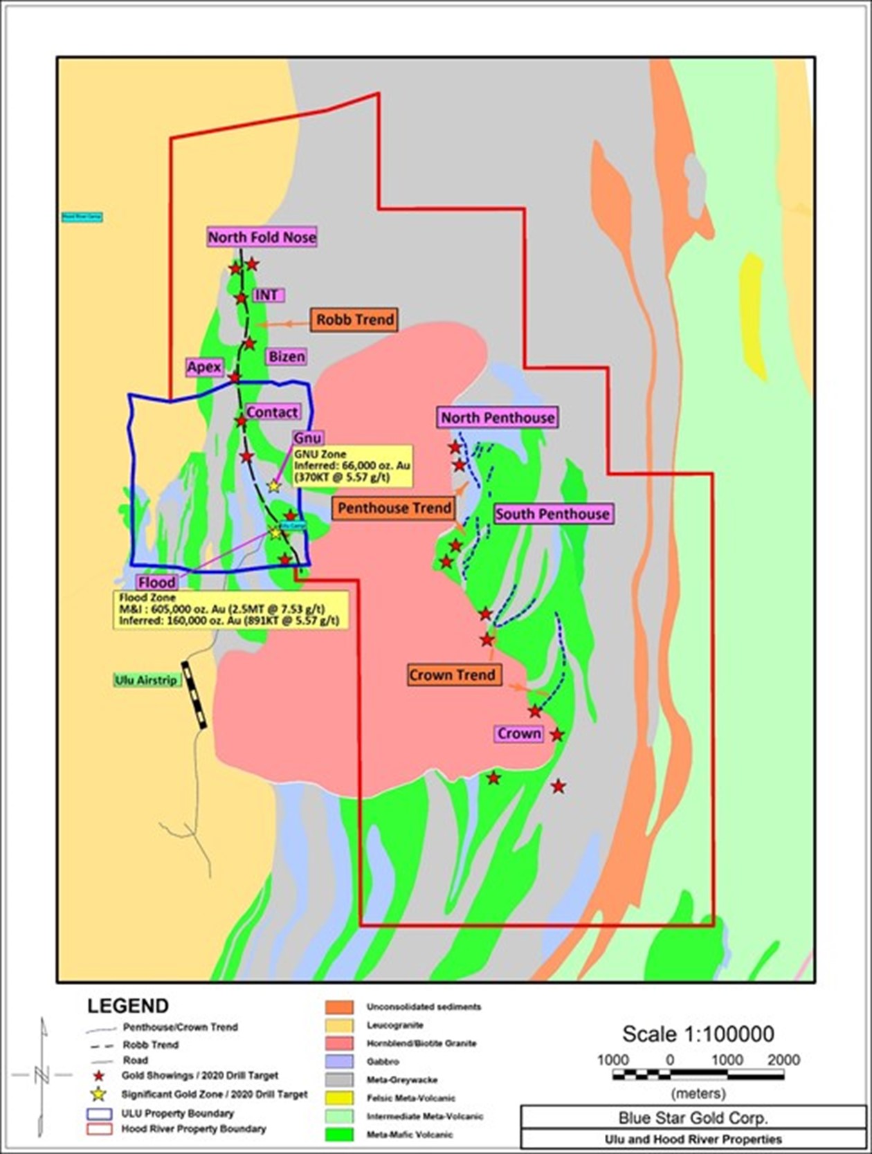
Figure 1. Ulu Property, Robb Trend

Figure 2. Ulu and Hood River Properties
Assay results for 2 holes returned from the Flood zone and 1 hole from the Gnu zone :
| Hole ID | Includes/And | From (m) | To (m) | Core Length (m) | Au (g/t) |
| BS2020ULU-004 | 400 | 401 | 1 | 2.72 | |
| 448 | 449 | 1 | 2.62 | ||
| 481 | 482 | 1 | 4.21 | ||
| 486 | 490 | 4 | 0.65 | ||
| 486 | 487 | 1 | 1.42 | ||
| 553 | 554 | 1 | 1.15 | ||
| 562 | 571 | 9 | 0.28 | ||
| 581 | 582 | 1 | 1.08 | ||
| 632 | 634 | 2 | 1.24 | ||
| INCLUDES | 633 | 634 | 1 | 2.18 | |
| BS2020ULU-006 | 377 | 383 | 6 | 0.78 | |
| 379 | 380 | 1 | 1.73 | ||
| 380 | 381 | 1 | 2.27 | ||
| 407 | 411 | 4 | 12.5 | ||
| INCLUDES | 408 | 409 | 1 | 21.3 | |
| AND | 409 | 410 | 1 | 22.4 | |
| 412 | 414 | 2 | 0.59 | ||
| 427 | 428 | 1 | 2.65 | ||
| 432 | 436 | 4 | 9.98 | ||
| INCLUDES | 433 | 434 | 1 | 12.15 | |
| AND | 434 | 435 | 1 | 13.55 | |
| 487 | 501 | 14 | 4.23 | ||
| INCLUDES | 491 | 492 | 1 | 14.8 | |
| 495 | 496 | 1 | 12 | ||
| 504 | 511 | 7 | 12.5 | ||
| INCLUDES | 504 | 505 | 1 | 7.15 | |
| AND | 505 | 506 | 1 | 30.8 | |
| AND | 508 | 509 | 1 | 10.4 | |
| AND | 509 | 510 | 1 | 21.8 | |
| AND | 510 | 511 | 1 | 11.85 | |
| 513 | 514 | 1 | 1.64 | ||
| 522 | 523 | 1 | 1.24 | ||
| BS2020ULU-007 | 25 | 27 | 2 | 52.7 | |
| INCLUDES | 25 | 26 | 1 | 33.6 | |
| AND | 26 | 27 | 1 | 71.8 | |
| 31 | 33 | 2 | 1.15 | ||
| 40 | 41 | 1 | 1.02 |
Assay results for 3 holes returned from the Hood River property:
| Hole ID | Includes/And | From (m) | To (m) | Core Length (m) | Au (g/t) |
| HR20-027 | 9 | 18 | 9 | 0.44 | |
| INCLUDES | 15 | 17 | 2 | 0.97 | |
| AND | 37 | 39 | 2 | 0.35 | |
| HR20-028 | 8 | 10 | 2 | 0.33 | |
| HR20-029 | 187 | 189 | 2 | 0.83 | |
| 207 | 209 | 2 | 0.74 | ||
| 249 | 263 | 15 | 0.43 | ||
| INCLUDES | 249 | 251 | 2 | 1.04 | |
| AND | 250 | 251 | 1 | 1.66 | |
| AND | 262 | 263 | 1 | 1.05 |
*Note that intervals listed in the above tables are core length, and not true width
QA/QC Program for the 2020 Exploration Work
All drill core was logged and sampled in secure core processing structures located at the Ulu or Hood River camps. Drill core samples were collected by either cutting the core in half using diamond saws or by splitting the core in half using hydraulic core splitters. In addition to the QA/QC protocols of ALS Global, the Company maintains its own program of inserting Standard Reference material in the form of standards and blanks into the sampling stream, prior to being shipped to ALS’s preparation facility in Yellowknife.
History and Geology of the Ulu and Hood River Gold Properties
The properties are located approximately 525 km NNE of Yellowknife, NT in the Kitikmeot region of western Nunavut. Kugluktuk is approximately 210 km to the NW.
The Ulu property consists of a renewable 21-year mining lease and covers an area of approximately 947 ha. The lease hosts an advanced gold project that between 1989 and 2012 saw significant exploration and development by BHP Minerals and Echo Bay Mines, among others. The past work includes approximately 1.7 km of underground development and approximately 405 diamond drill holes that produced 97,820 m of core (Ulu and Hood River). The Flood zone contains the bulk of the Ulu gold resource and is open on-strike and at depth. Overall resources of 2.50 million tonnes grading 7.53 g/t Au for 605,000 gold ounces (measured & indicated category) and 1.26 million tonnes grading 5.57 g/t Au for 226,000 gold ounces (inferred category) have been estimated for the Flood and Gnu zones (refer to “Technical Report on the Ulu Gold Property, Nunavut, Canada” dated July 10, 2015). The deepest intersection of mineable width at the Flood zone is 14.9 g/t Au over 7.7 m in BHP’s drill hole 90VD-75 at 610 m below surface. Metallurgical testing on the Flood zone gold mineralization has shown that gold is recoverable in amounts greater than 90% by gravity, flotation and cyanidation.
The Hood River property is contiguous to the Ulu lease to the north, east and south. The property is held through a renewable, 20 year Mineral Exploration Agreement with Nunavut Tunngavik Incorporated. The highly prospective property encompasses 8,015 ha. At least 22 known gold showings have been identified on the property. The exploration target for the property is shear-hosted gold mineralization similar to the Flood zone on the adjacent Ulu lease.
A series of gold occurrences occur on-strike and north of the Flood gold zone and are thought to be related to the ~5 km long Ulu regional fold that extends from the Ulu lease onto the north Hood River property culminating at the NFN zone. This structure, called the Robb trend, extends from the Flood and Gnu gold zones along the Ulu fold to the north and hosts at least five gold zones in addition to the Flood and Gnu zones (NFN, INT, Bizen, Apex and Contact zones).
Gossanous auriferous rocks hosted within mafic volcanic units at or close to the contact with meta-greywacke rocks occur along the Robb trend. The gold mineralization is commonly enveloped by an alteration halo of biotite-actinolite-quartz. The mineralized zones are believed to be the result of brittle-ductile failure caused by regional stresses during different deformation stages. Along sedimentary-volcanic contacts, regional folding causing shearing, due to lithological competency contrasts, resulted in minor dilatancy. These dilatational zones were in-filled with the gold-arsenic-rich hydrothermal fluids. Mineralization shows pinch and swell style.
Several high-grade gold occurrences also occur on the east Hood River property, including the Crown and Penthouse zones, where gold trends with similarities to the Robb trend may exist. In addition, many unnamed gold occurrences exist on the two properties, where further prospecting is required to advance the showings to target zones. The large number of high-grade gold showings that occur throughout the properties provide for excellent resource expansion potential at multiple targets.
Supplementing the high-grade gold resources, the Ulu project includes a substantial inventory of capital equipment, a Weatherhaven camp with shop and a 1,200 m long airstrip. The site of the future deep-water port at Grays Bay is 100 km to the north of the properties, and the proposed route corridor for the all-weather Grays Bay road passes in close proximity to the Ulu and Hood River projects.
Ulu Resource Estimate:
| Classification | Gold | Tonnage | Gold Grade | Gold Contained |
| Cut-off (g/t) | Tonnes | g/t | Oz | |
| Flood Zone | ||||
| Measured | > 4.0 | 1,000,000 | 8.48 | 272,000 |
| Indicated | > 4.0 | 1,500,000 | 6.90 | 333,000 |
| Measured & Indicated | > 4.0 | 2,500,000 | 7.53 | 605,000 |
| Inferred | > 4.0 | 891,000 | 5.57 | 160,000 |
| Gnu Zone | ||||
| Inferred | > 4.0 | 370,000 | 5.57 | 66,000 |
| Total – Flood and Gnu Zones | ||||
| Measured & Indicated | > 4.0 | 2,500,000 | 7.53 | 605,000 |
| Inferred | > 4.0 | 1,261,000 | 5.57 | 226,000 |
Notes to the Resource Estimate
Qualified Person
Warren Robb P.Geo. a Qualified Person under National Instrument 43-101 (“NI 43-101”), has reviewed and approved the geological information contained in this news release.
About Blue Star Gold Corp.
Blue Star is a Vancouver-based gold and silver company focused on exploration and development within Nunavut, Canada. The Company owns the Ulu Gold Property lease, an advanced gold and silver project, and the highly prospective Hood River gold concessions that are contiguous with the Ulu mining lease. The combined properties total approximately 9,000 ha of prospective mineral claims within which the Company has a significant high-grade gold resource on the Ulu lease, and numerous high-grade gold occurrences and priority targets throughout the Ulu and Hood River properties.
Blue Star has 164.8 million shares outstanding and is listed on the TSX Venture Exchange.
PPX Mining Corp. is pleased to announce that it has closed its fu... READ MORE
Elevation Gold Mining Corporation (TSX-V: ELVT) (OTCQB: EVGDF) i... READ MORE
Reunion Gold Corporation (TSX-V: RGD; OTCQX: RGDFF) is pleased to announ... READ MORE
Puma Exploration Inc. (TSX-V: PUMA) (OTCQB: PUMXF) is thrilled to... READ MORE
Grid Metals Corp. (TSX-V:GRDM) (OTCQB:MSMGF) is pleased to announ... READ MORE


