








Blue Star Gold Corp. (TSX-V: BAU) (OTCQB: BAUFF) (FSE: 5WP0) announces initial results from Phase 2 of its 2026 Exploration Program at the Auma Project. This is the Company’s first drill program at this highly prospective area for both gold and critical metals. Blue Star is a leading explorer in Canada’s North with its projects strategically located along the proposed Grays Bay Road in the High Lake Belt, West Kitikmeot Region of Nunavut (Figure 1). Initial results are reported below from the first pass drill targeting of the Bamako prospect, Auma Project.
Highlights
“Compilation work by the exploration team led to expansion of the Auma project to district-scale earlier this year. The potential for both gold and critical minerals resulted in early drill planning to test both gold and critical minerals discovery targets,” said Grant Ewing, CEO of Blue Star. “These initial drill results are encouraging, confirming a significant gold system at Bamako over the 300 metres of drill-tested strike. Follow-up drilling is underway as we continue to evaluate the potential for Auma to develop into a new gold resource centre in the High Lake Belt.”
Discussion of Auma (Bamako)
The expanded Auma Project (News Release dated February 18, 2026) encompasses a district-scale land position prospective for both high-grade orogenic gold and volcanogenic massive sulphide (VMS) mineralization. The original Auma showing hosts high-grade, vein-hosted gold mineralization, including surface samples exceeding 100 g/t Au. Mineralization is associated with quartz veins, sulphide-rich selvages, and alteration halos. Historical drilling tested only a limited portion of the known mineralized system, while recent surface exploration significantly expanded the mineralized footprint beyond previously drilled areas. The enlarged property now covers approximately 11,794 hectares of Crown and Inuit Owned Lands and includes multiple styles of mineralization, including carbonate-altered shear-hosted gold and VMS-related zinc and copper occurrences, highlighting the project’s strong discovery potential and the significant opportunity presented by the large areas that remain unexplored.
The current 2,400-metre maiden drill program at Auma was designed to test the property’s highest-priority gold and copper-gold targets. The drill program is focused on understanding and extending known mineralization at the Bamako prospect, evaluating high-grade surface gold discoveries, and completing a reconnaissance test of the Penny Lane copper-gold target discovered in 2025 (News Release dated September 10, 2025). The program is supported by an extensive historical and modern exploration database, including drilling, geological mapping, surface geochemistry, and multiple airborne and ground geophysical surveys, providing a strong technical foundation for prioritizing targets and reducing exploration risk (Figure 2).
Drilling at Bamako has intersected a broad system of altered volcanic and sedimentary rocks containing quartz veining and sulphide mineralization, with multiple structurally controlled mineralized intervals identified across the first five holes. The results confirm the continuity of mineralization between previously tested areas and provide additional evidence that the Bamako system extends beyond the limits of historical drilling. Assay results received to date include several high-grade intervals, with the strongest results including 8.0 m grading 2.65 g/t Au and 1.9 m grading 16.74 g/t Au in 26ABD003, and 2.0 m grading 10.60 g/t Au in 26ABD005. Additional significant intervals occur throughout the holes, demonstrating multiple mineralized zones within the broader Bamako system.
Hole 26ABD001 tested beneath historical high-grade gold intersections and investigated several geophysical and geochemical targets interpreted to represent extensions of known mineralization. The hole returned 1.0 m grading 5.20 g/t Au from 72.0 m, 5.4 m grading 0.73 g/t Au from 83.0 m, and 2.4 m grading 2.76 g/t gold from 163.8 m.
Hole 26ABD002 was drilled as an undercut scissor hole to 26ABD001 to better understand the orientation and continuity of mineralized zones identified in the previous hole. Assay results include 1.7 m grading 0.57 g/t Au from 60.4 m, 0.4 m grading 2.35 g/t Au from 111.1 m, 1.9 m grading 1.22 g/t Au from 117.1 m, 4.3 m grading 0.51 g/t Au from 130.7 m, and 1.3 m grading 1.26 g/t Au from 211.2 m, supporting continuity of mineralized structures between the two drill holes.
Hole 26ABD003 tested beneath a large, mineralized surface exposure containing high-grade rock samples and was drilled from the opposite direction to improve the understanding of the mineralized structure(s). The hole returned 8.0 m grading 2.65 g/t Au from 22.9 m, 2.0 m grading 9.44 g/t Au from 59.0 m, 3.1 m grading 1.68 g/t Au from 141.0 m, and 1.9 m grading 16.74 g/t Au from 155.0 m, confirming significant gold mineralization over a broad section of the hole (Figure 3).
Hole 26ABD004 was the first drill hole into the previously undrilled northern portion of the Bamako trend, targeting exceptional historical surface gold values. The hole returned 0.2 m grading 4.52 g/t Au from 111.9 m, 0.3 m grading 1.02 g/t Au from 151.5 m, and 0.8 m grading 2.39 g/t Au from 168.4 m, demonstrating gold mineralization within the previously undrilled area.
Hole 26ABD005 stepped between 26ABD001/002 and 26ABD004 to confirm continuity along the Bamako trend. The drill hole returned 2.0 m grading 10.60 g/t Au from 57.2 m (visible gold observed – Plate 1), 2.1 m grading 3.47 g/t Au from 61.0 m, 0.3 metres grading 3.32 g/t Au from 75.9 m, 2.7 m grading 1.13 g/t Au from 86.0 m, and 0.5 m grading 5.77 g/t Au from 182.0 m.
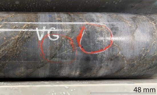
Plate 1: 26ABD005 Very Fine, Disseminated Visible Gold (VG), Auma Project.
Next Steps
Auma drilling confirmed the presence and continuity of a significant gold mineralised system over a drill tested 300 metres of strike length at shallow depths. Planning for follow-up drilling based on the results received to date is underway focused on evaluating similar coincident features, and parallel and link structures. A review of the captured data will be conducted post season to generate a geological and structural model to direct further work programs in 2027, with an objective of defining a new gold resource centre in the High Lake Belt.
Sampling, Assaying & QA/QC
Blue Star field programs collect a variety of samples; prospecting rock samples are selective by nature, channel samples are saw-cut samples from outcrop intended to be representative of the exposed mineralisation, and drill core samples are sawn in half with one half retained as core record and the other half submitted for analysis.
Blue Star samples are delivered under chain of custody to ALS Geochemistry in Yellowknife, NT for sample preparation which are then forwarded to ALS Canada Inc. in North Vancouver, BC for final analysis. Samples are prepared using code PREP-31 (crushing and pulverising) and analysed using codes Au-AA26 (50-gram fire assay with atomic absorption finish) and ME-MS61 (48 element four acid digestion with ICP-MS finish). Samples returning >10 g/t Au are reanalysed under code Au-GRA22 (50-gram fire assay with gravimetric finish). Over limits for non-gold elements are ore grade four acid digestion with ICP-AES finish. The work is being conducted using industry standard procedures, including a quality assurance and quality control (“QA/QC”) program consisting of the insertion of certified standards, blanks and duplicates into the sample stream.
Darren Lindsay, P. Geo. and Vice President Exploration for Blue Star, is a Qualified Person under National Instrument 43-101 (“NI 43-101”) and has reviewed and approved the technical information contained in this news release.
Table of Drill Collars
| HoleID | Easting | Northing | Elevation | Azimuth | Dip | Length (m) |
| 26ABD001 | 492018 | 7446092 | 462 | 069 | -45 | 248 |
| 26ABD002 | 492018 | 7446092 | 462 | 070 | -59 | 251 |
| 26ABD003 | 492246 | 7446015 | 455 | 250 | -44 | 191 |
| 26ABD004 | 491950 | 7446259 | 461 | 080 | -45 | 199 |
| 26ABD005 | 491997 | 7446204 | 462 | 080 | -44 | 203 |
Table of Results (ADB001 – ABD005)*
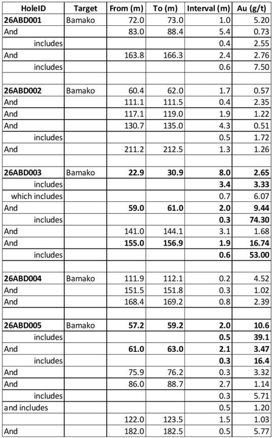
*Intervals are down hole lengths; there has been insufficient drilling to determine true thicknesses.
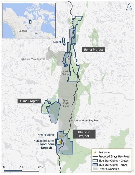
Figure 1: Location Map Showing Blue Star’s Landholdings.
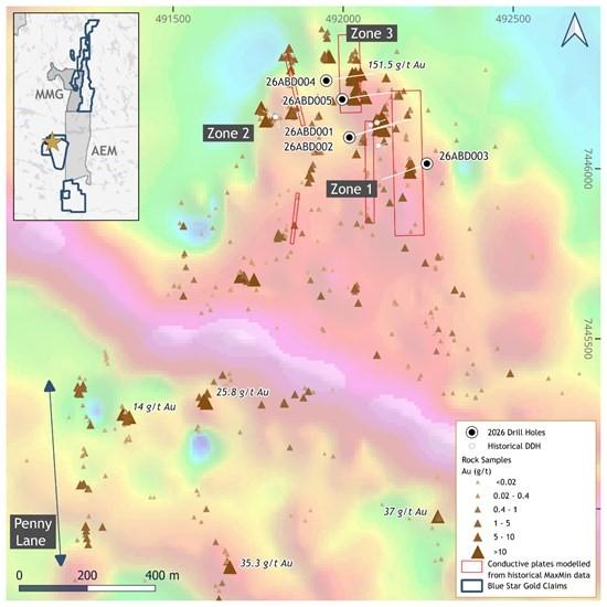
Figure 2: Bamako Targets, Auma Project Shown on SkyTEM Total Magnetics.
Data Overlain with Gold Grades from Rock Samples.
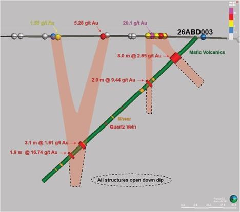
Figure 3: Northward Looking, Vertical Cross Section of Drill Hole 26ABD003, Bamako Target.
About Blue Star Gold Corp.
Blue Star is a mineral exploration and development company focused on Nunavut, Canada. The Company controls over 420 square kilometres of highly prospective and underexplored mineral properties in the High Lake Greenstone Belt. Its principal assets include the Ulu Gold Project – comprised of the Ulu Mining Lease and Hood River Property, and the Roma and Auma Projects. The Ulu Mining Lease hosts the high-grade Flood Zone Gold Deposit, and the Company’s broader land package contains numerous high-priority gold and critical mineral targets, providing substantial upside potential for Mineral Resource expansion.
Grays Bay Road and Port Project: On June 24, 2026, the Government of Canada stated it had initiated consultations to consider listing the Grays Bay Road and Port Project (GBRPP) under Schedule 1 of the Building Canada Act. Following the March 12, 2026, announcement by Prime Minister Mark Carney that the GBRPP would be referred to the Major Projects Office, this is a further endorsement of the national significance of the GBRPP, which can accelerate its development (https://www.westkit.ca/news). Blue Star’s projects are strategically located 40-100 km south of the proposed Grays Bay deep-water port, with the planned all-weather Grays Bay Road corridor passing very close to the Company’s projects.
Brutus Mining Inc. (CSE: BRU) (FSE: ZI3) is pleased to announce that it has closed its non-brokered ... READ MORE
Jaguar Uranium Corp. (NYSE American: JAGU) is pleased to announce an independent Mineral Resource E... READ MORE
Auro Metals Inc. (TSX-V: AURO) (OTCQB: AURFF), is pleased to announce the assay results of the fina... READ MORE
Endeavour Silver Corp. (NYSE: EXK) (TSX: EDR) is pleased to announce that repairs to the primary bal... READ MORE
Scorpio Gold Corp. (NASDAQ: SGLD) (TSX-V: SGLD) (OTCQB: SRCRF) (FSE: RY9) is pleased to announce re... READ MORE


