


![]()
Blackrock Silver Corp. (TSX-V: BRC) (OTCQX: BKRRF) (FSE: AHZ0) announces the final results from its fully-funded eastern expansion drill program at its 100% owned Tonopah West project located in Nye and Esmeralda Counties, Nevada, United States.
EASTERN EXPANSION PROGRAM HIGHLIGHTS:
The Eastern Expansion Program was a follow up to the Company’s successful Scout drilling program completed at Tonopah West in February 2025 (see March 31, 2025 news) which shows additional upside for the shallow southern portion of the Denver-Paymaster and Bermuda-Merten vein groups resource area to expand the resource area 1,200 metres in an easterly direction.
The Company commenced the Eastern Expansion Program in July 2025 within the Eastern Expansion Zone, utilizing reverse circulation (RC) drilling with RC pre-collars to establish initial holes, which were then deepened using diamond core drilling (core tails) for more detailed geological analysis. The Program drilled a total of 6,798 metres (22,896 feet) in twenty-four drillholes, however, only 22 drillholes were completed, as two pre-collar holes were not usable for core tails. Of the 22 completed drillholes, three were core holes completed from surface.
Andrew Pollard, Blackrock’s President and CEO, stated, “Whereas we set out to target a single east-west mineralized structure, drilling from our Eastern Expansion Program has defined at least three distinct, parallel mineralized zones oriented northwest. These structures appear to be splays off the Pittsburgh-Monarch fault system. Each of these zones has intersected shallow, high-grade, and thick mineralization, indicating significant potential for further expansion in the area. Additionally, drilling in the M&I Conversion Area at DPB South has successfully connected previously isolated intercepts, confirming the presence of north-south trending structures and suggesting additional tonnage potential. Work on our upcoming mineral resource estimate and preliminary economic assessment is now underway and on track for a targeted completion date in February 2026. These will incorporate data from both our Northwest and Eastern Expansion drill programs.”
Table 1 summarizes the final results of the Eastern Expansion Program using a cut-off grade of 150 g/t AgEq.
Table 1: Eastern Expansion Drill Program Significant Results Using a 150 g/t AgEq Cut-off Grade
| Drillhole ID |
Program | Area | Hole Type |
From (m) | To (m) | Drillhole Interval (m) |
Ag g/t | Au g/t | AgEq g/t |
| TXC25-168 | E Expansion | DPB South | RC/Core | 298.03 | 299.86 | 1.83 | 73.7 | 0.754 | 156.1 |
| Including | 298.03 | 298.34 | 0.31 | 353.0 | 3.680 | 754.8 | |||
| TXC25-171 | M&I Conversion | DPB South | RC/Core | 185.99 | 186.69 | 0.70 | 122.0 | 1.100 | 242.1 |
| TXC25-171 | M&I Conversion | DPB South | RC/Core | 247.19 | 249.33 | 2.13 | 85.7 | 0.855 | 179.1 |
| TXC25-173 | E Expansion | DPB South | RC/Core | 215.53 | 216.56 | 1.04 | 189.8 | 3.159 | 534.8 |
| TXC25-173 | E Expansion | DPB South | RC/Core | 220.98 | 221.90 | 0.92 | 1,162.0 | 8.798 | 2,122.7 |
| TXC25-178 | M&I Conversion | DPB South | RC/Core | 161.54 | 162.61 | 1.07 | 158.5 | 2.126 | 390.6 |
| TXC25-178 | M&I Conversion | DPB South | RC/Core | 183.80 | 190.20 | 6.40 | 135.7 | 1.474 | 296.6 |
| Including | 188.37 | 188.82 | 0.46 | 1,771.0 | 19.067 | 3,853.0 | |||
| TXC25-178 | M&I Conversion | DPB South | RC/Core | 270.36 | 271.43 | 1.07 | 108.9 | 1.439 | 266.0 |
| Including | 271.12 | 271.43 | 0.31 | 375.0 | 4.750 | 893.7 | |||
| AgEq = Ag + Au/(Factor); where Factor = (Ag Price/Au Price)*(Ag Recovery/Au Recovery) or Factor=($27/$2,700)*(87%/95%)=0.009157; True thickness is 75% to 85% of drill interval; NSV=No values above cut off; Cut-off grade is 150 gpt AgEq; RC/Core = RC pre-collar with core tail; Core is core from the surface. | |||||||||
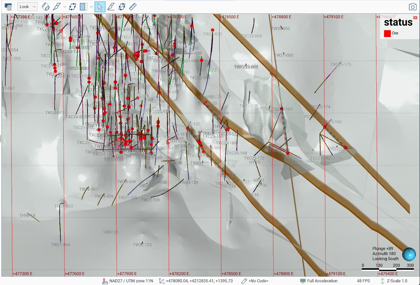
The Eastern Expansion Program encountered at least three northwest oriented structures which appear to be mineralized and offset the southern caldera margin to the northeast. The structures are parallel to the Pittsburg-Monarch fault and suggest a series of footwall fault splays associated with the main Pittsburg-Monarch fault. Figure 1 below shows the approximate location and orientation of the northwest fault system.
Drilling to date shows shallow, high-grade, and thick zones of mineralization in each of these structures and suggest increased expansion potential along this northwest structural corridor. Historically, the Pittsburg-Monarch fault was considered an ore control within the district with the thickest historically mined veins at Victor and Ohio abutting the main fault. The Company’s drilling in the Eastern Expansion Zone has returned thick vein intervals of gold and silver along the parallel structures confirming the importance of the Pittsburg-Monarch and its footwall fault splays.
Two drillholes, TXC25-171 and TXC25-178, were drilled in the M&I Conversion Area. These drillholes were directed to the west to understand several north-south structures encountered in the previous drilling. The Program was successful in capturing high-grade drill intervals from the north-south structures and shows there are multiple mineralized structures with similar orientation in the area.

Figure 1: Leapfrog model showing northwest oriented structures in the Eastern Expansion area
To view an enhanced version of this graphic, please visit:
https://images.newsfilecorp.com/files/676/276546_9dcdee45e417e956_001full.jpg
Although below the cut-off grade of 150 g/t AgEq, drillholes TXC25-167, -168, -175, -176, -177 and TXC25-179 were mineralized with silver equivalent values ranging between 31 and 133 g/t AgEq. Table 2 shows the range of gold and silver values encountered along the northwest oriented structures.
Table 2: Mineralized Drillholes from the Eastern Expansion program that are below the 150 g/t AgEq cut-off
| Drillhole ID |
Program | Area | Hole Type |
From (m) | To (m) | Drillhole Interval (m) |
Ag g/t | Au g/t | AgEq g/t |
| TXC25-167 | E Expansion | Ohio | RC/Core | 368.96 | 372.01 | 3.05 | 133.0 | 0.002 | 133.2 |
| TXC25-169 | E Expansion | DPB South | RC/Core | 196.90 | 199.95 | 3.05 | 1.2 | 0.480 | 53.6 |
| TXC25-175 | E Expansion | Ohio | RC/Core | 277.98 | 279.69 | 1.71 | 14.2 | 0.155 | 31.2 |
| TXC25-176 | E Expansion | Ohio | Core | 192.51 | 194.46 | 1.95 | 13.9 | 0.173 | 32.8 |
| TXC25-177 | E Expansion | Ohio | Core | 177.09 | 178.31 | 1.22 | 2.5 | 0.467 | 53.5 |
| TXC25-179 | E Expansion | Ohio | Core | 235.55 | 236.46 | 0.91 | 23.3 | 0.270 | 52.8 |
| TXC25-179 | E Expansion | Ohio | Core | 262.28 | 263.35 | 1.07 | 16.9 | 0.167 | 35.1 |
| AgEq = Ag + Au/(Factor); where Factor = (Ag Price/Au Price)*(Ag Recovery/Au Recovery) or Factor=($27/$27,00)*(87%/95%)=0.009157; True thickness is 75% to 85% of drill interval; NSV=No values above cut off; Cut-off grade is 150 gpt AgEq; RC/Core = RC pre-collar with core tail; Core is core from the surface. | |||||||||
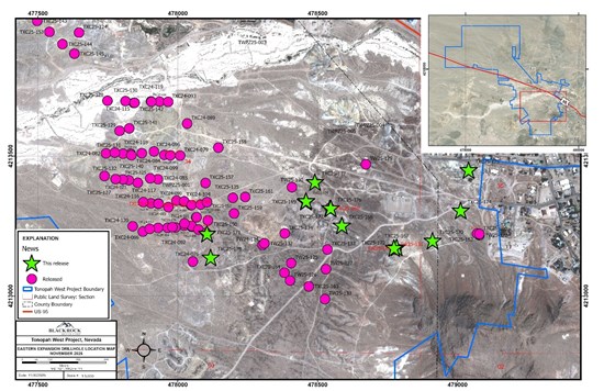
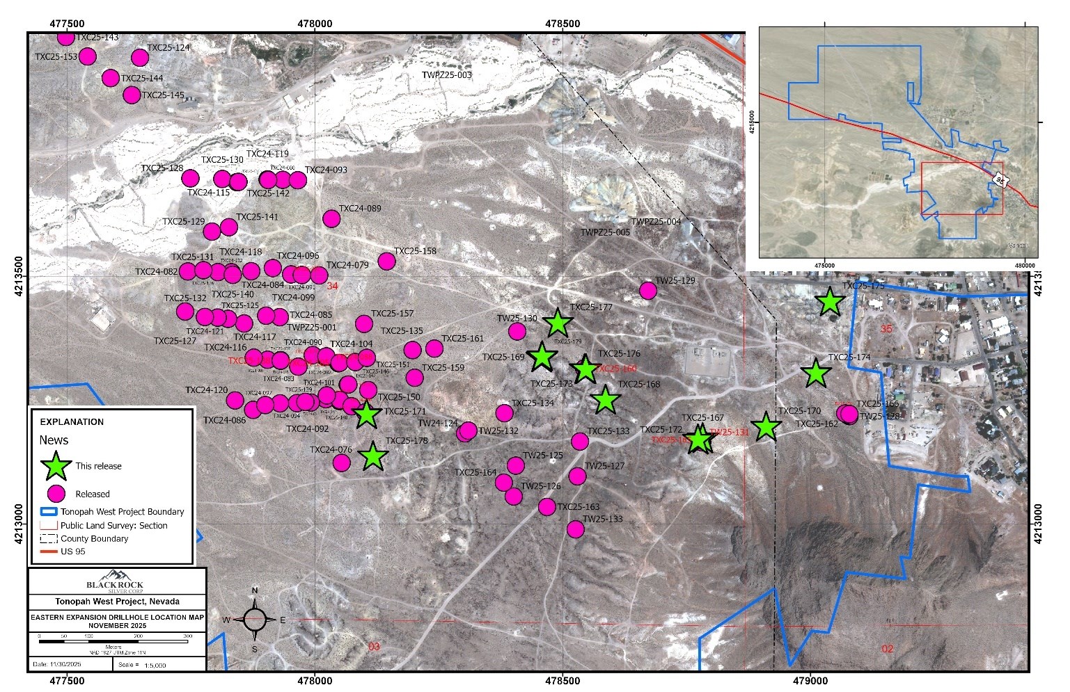
Figure 2: Drillhole location map for the Eastern Expansion drillholes reported in this news release
To view an enhanced version of this graphic, please visit:
https://images.newsfilecorp.com/files/676/276546_9dcdee45e417e956_002full.jpg
Below are all the drillhole intervals above the 150 g/t AgEq cut off from the program showing the upside potential of the Eastern Expansion Zone.
Table 3: Eastern Expansion Program Significant Results Using a 150 g/t AgEq Cut-off Grade (TXC25-156 to TXC25-166 released on October 27, 2025)
| Drillhole ID |
Program | Area | Hole Type |
From (m) | To (m) | Drillhole Interval (m) |
Ag g/t | Au g/t | AgEq g/t |
| TXC25-158 | E Expansion | DPB South | RC/Core | 146.30 | 147.83 | 1.52 | 123.0 | 0.852 | 216.0 |
| TXC25-158 | E Expansion | DPB South | RC/Core | 272.83 | 273.86 | 1.04 | 17.9 | 2.353 | 274.8 |
| Including | 273.56 | 273.86 | 0.30 | 59.8 | 7.970 | 930.1 | |||
| TXC25-158 | E Expansion | DPB South | RC/Core | 340.31 | 341.13 | 0.82 | 56.9 | 0.671 | 130.2 |
| TXC25-159 | E Expansion | DPB South | RC/Core | 234.18 | 242.93 | 8.75 | 90.3 | 0.943 | 193.3 |
| Including | 241.65 | 242.47 | 0.82 | 567.7 | 5.953 | 1,217.8 | |||
| TXC25-160 | E Expansion | DPB South | RC/Core | 146.30 | 147.83 | 1.52 | 79.4 | 6.660 | 806.6 |
| TXC25-164 | E Expansion | DPB South | RC/Core | 180.44 | 186.11 | 5.67 | 3.6 | 2.379 | 263.4 |
| Including | 185.01 | 186.11 | 1.10 | 9.2 | 8.670 | 955.9 | |||
| TXC25-166 | E Expansion | Ohio | RC/Core | 160.17 | 160.78 | 0.61 | 114.9 | 1.658 | 296.0 |
| TXC25-166 | E Expansion | Ohio | RC/Core | 165.20 | 170.23 | 5.03 | 306.8 | 4.062 | 750.3 |
| Including | 166.73 | 168.56 | 1.83 | 724.1 | 8.577 | 1,660.6 | |||
| TXC25-168 | E Expansion | DPB South | RC/Core | 298.03 | 299.86 | 1.83 | 73.7 | 0.754 | 156.1 |
| Including | 298.03 | 298.34 | 0.31 | 353.0 | 3.680 | 754.8 | |||
| TXC25-171 | M&I Conversion | DPB South | RC/Core | 185.99 | 186.69 | 0.70 | 122.0 | 1.100 | 242.1 |
| TXC25-171 | E Expansion | DPB South | RC/Core | 247.19 | 249.33 | 2.13 | 85.7 | 0.855 | 179.1 |
| TXC25-173 | E Expansion | DPB South | RC/Core | 215.53 | 216.56 | 1.04 | 189.8 | 3.159 | 534.8 |
| TXC25-173 | E Expansion | DPB South | RC/Core | 220.98 | 221.90 | 0.92 | 1,162.0 | 8.798 | 2,122.7 |
| TXC25-178 | M&I Conversion | DPB South | RC/Core | 161.54 | 162.61 | 1.07 | 158.5 | 2.126 | 390.6 |
| TXC25-178 | M&I Conversion | DPB South | RC/Core | 183.80 | 190.20 | 6.40 | 135.7 | 1.474 | 296.6 |
| Including | 188.37 | 188.82 | 0.46 | 1,771.0 | 19.067 | 3,853.0 | |||
| TXC25-178 | M&I Conversion | DPB South | RC/Core | 270.36 | 271.43 | 1.07 | 108.9 | 1.439 | 266.0 |
| Including | 271.12 | 271.43 | 0.31 | 375.0 | 4.750 | 893.7 | |||
| AgEq = Ag + Au/(Factor); where Factor = (Ag Price/Au Price)*(Ag Recovery/Au Recovery) or Factor=($27/$2,700)*(87%/95%)=0.009157; True thickness is 75% to 85% of drill interval; NSV=No values above cut off; Cut-off grade is 150 gpt AgEq; RC/Core = RC pre-collar with core tail; Core is core from the surface. | |||||||||
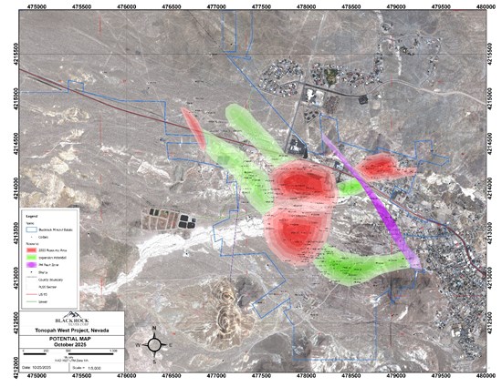
Figure 3: Tonopah West expansion potential
To view an enhanced version of this graphic, please visit:
https://images.newsfilecorp.com/files/676/276546_9dcdee45e417e956_003full.jpg
Figure 4: Tonopah West Drillhole Location Coordinates (based on GPS readings in the field, Datum UTM, NAD 1927, Zone 11)
| Drillhole ID | Area | Program | Type | UTM_NAD27 E | UTM_NAD27 N | Elevation (m) |
Depth (ft) |
Depth (m) |
Azimuth | Dip |
| TXC25-167 | Ohio | E Expansion | RC/Core | 478778.0 | 4213176.0 | 1824.5 | 1302.0 | 396.8 | 25 | -60 |
| TXC25-168 | DPB South | E Expansion | RC/Core | 478600.0 | 4213250.0 | 1800.0 | 1072.0 | 326.7 | 180 | -65 |
| TXC25-169 | DPB South | E Expansion | RC/Core | 478460.0 | 4213340.0 | 1800.0 | 939.0 | 286.2 | 180 | -65 |
| TXC25-170 | Ohio | E Expansion | RC/Core | 478910.0 | 4213200.0 | 1835.0 | 894.0 | 272.5 | 230 | -70 |
| TXC25-171 | DPB South | M&I Conversion | RC/Core | 478105.0 | 4213222.0 | 1789.0 | 1315.0 | 400.8 | 270 | -50 |
| TXC25-172 | Ohio | E Expansion | RC/Core | 478778.0 | 4213176.0 | 1824.5 | 898.5 | 273.9 | 225 | -65 |
| TXC25-173 | DPB South | E Expansion | RC/Core | 478540.0 | 4213310.0 | 1800.0 | 903.0 | 275.2 | 180 | -75 |
| TXC25-174 | Ohio | E Expansion | RC/Core | 479014.0 | 4213300.0 | 1822.0 | 921.0 | 280.7 | 40 | -70 |
| TXC25-175 | Ohio | E Expansion | RC/Core | 479046.0 | 4213457.0 | 1820.0 | 1232.0 | 375.5 | 40 | -50 |
| TXC25-176 | Ohio | E Expansion | Core | 478540.0 | 4213310.0 | 1800.0 | 1060.0 | 323.1 | 210 | -75 |
| TXC25-177 | Ohio | E Expansion | Core | 478495.0 | 4213405.0 | 1791.0 | 732.0 | 223.1 | 0 | -90 |
| TXC25-178 | DPB South | M&I Conversion | RC/Core | 478113.0 | 4213139.0 | 1791.0 | 1728.5 | 526.8 | 270 | -50 |
| TXC25-179 | Ohio | E Expansion | Core | 478460.0 | 4213340.0 | 1800.0 | 922.0 | 281.0 | 0 | -90 |
About Blackrock Silver Corp.
Backed by gold and silver ounces in the ground, Blackrock is a junior precious metal focused exploration and development company driven to add shareholder value. Anchored by a seasoned Board of Directors, the Company is focused on its 100% controlled Nevada portfolio of properties consisting of low-sulphidation, epithermal gold and silver mineralization located along the established Northern Nevada Rift in north-central Nevada and the Walker Lane trend in western Nevada.
Additional information on Blackrock Silver Corp. can be found on its website at www.blackrocksilver.com and by reviewing its profile on SEDAR at www.sedarplus.ca.
For Further Information, Contact:
Andrew Pollard
President and Chief Executive Officer
(604) 817-6044
info@blackrocksilver.com
Hudbay Minerals Inc. (TSX:HBM) (NYSE: HBM) today released its ann... READ MORE
Strategic acquisition of an established operating gold mine, loca... READ MORE
Cerro de Pasco Resources Inc. (TSX-V: CDPR) (OTCQB: GPPRF) (FRA: ... READ MORE
The Garneau Titanium Project Features Ilmenite-Rich Boulder with ... READ MORE
ValOre Metals Corp. (TSX‐V: VO) (OTCQB: KVLQF) (Frankfurt: KEQ0... READ MORE


