








Auro Metals Inc. (TSX-V: AURO) (OTCQB: AURFF) is pleased to announce the fifth batch of assay results, of three drillholes, from the 2026 Phase I Drill Program at its 100%-owned Santa Barbara Gold-Copper Project located in the Zamora-Chinchipe Province in southeastern Ecuador. Since the commencement of the program, 22 drillholes have been completed and assay results of 17 holes (including the fourteen holes released on June 22, July 13, July 28 and August 18, 2026) have been received. Additionally, the Company is pleased to announce that it has completed the Phase I Drill Program consisting of 11,047.35 metres and has continued without interruption into its Phase II – 20,000m Drill Program at the Project.
SUMMARY OF DRILL RESULTS
These three holes were drilled at the southern part of the known mineralized porphyry system (“Santa Barbara South”), which is currently believed to be the core area of the known porphyry mineralization system. Like the previously reported holes from the 2026 Phase I Drill Program, these holes were designed to test the continuity of mineralization between historical drill intercepts and the extension of mineralization up-dip, down-dip, and at depth. Highlights are as follows:
“This latest batch of drillholes continues to demonstrate the scale and consistency at Santa Barbara. These results, along with the previously reported intercepts, continue to demonstrate that mineralization is open up-dip, down-dip, and at depth,” said Victor Feng, CEO of Auro. “DSB-68 is the longest and deepest hole drilled at Santa Barbara. On a gram by metre basis, it returned the best reportable intercept at the Project to date, including all historical drilling. The hole remained mineralized to the end at a depth of 1,282m, showing mineralization is open at depth. DSB-69 showed mineralization is open down-dip and DSB-70 intersected higher-grade gold at depth.”
“The Phase I Drill Program was successful in confirming historical drill results, increasing drill density in inferred resource areas, and in several cases, showed mineralization remains open in all directions and at depth. Completion of Phase I also gives us fresh core to begin our own initial metallurgical test work. With 17 holes published to date, assay results for the remaining 5 Phase I drillholes will be published as they become available.”
“Our Phase II – 20,000m Drill Program is already underway. We will increase the overall drilling speed with the addition of three rigs, each capable of drilling to a depth of more than 1,000m. This allows us to test extensions of the mineralized zones at depth, as multiple long holes from Phase I ended in mineralization. Phase II will focus on testing gaps between known parts of the deposit, stepping out to test new targets, and drilling deeper than has ever been drilled at the Project.”
These drill results are summarized in Table 1 below. Drillhole specifications for all completed Phase I drillholes are provided in Table 2, and a drill plan view is shown in Figure 1.
Table 1 Summary of Drill Intercepts
| Hole_ID | Depth_from | Depth_to | Interval_m | Au_g/t | Cu_% | AuEq_g/t | |
| DSB-68 | 56.50 | 961.72 | 905.22 | 0.60 | 0.12 | 0.63 | |
| DSB-69 | 70.45 | 173.50 | 103.05 | 0.53 | 0.09 | 0.56 | |
| 247.45 | 448.00 | 200.55 | 0.59 | 0.08 | 0.61 | ||
| incl. | 266.67 | 324.50 | 57.83 | 1.06 | 0.10 | 1.08 | |
| DSB-70 | 10.00 | 272.50 | 262.50 | 0.71 | 0.10 | 0.73 | |
| incl. | 169.35 | 269.80 | 100.45 | 1.01 | 0.11 | 1.04 |
Notes:
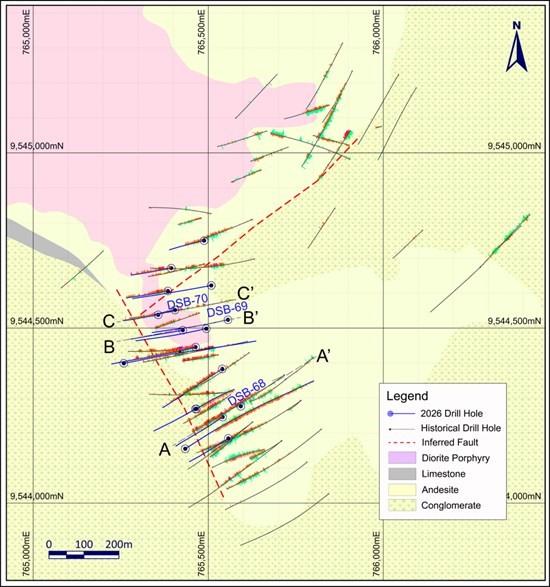
Figure 1: Plan view of drillholes
SUMMARY OF PHASE I DRILL PROGRAM
Phase I consisted of 11,047.35m across 22 drillholes. Results for 17 holes have been published to date, with the remaining 5 pending to be released once assays become available.
Phase I was designed to: (i) confirm historical drill results; (ii) complete infill drilling to upgrade the existing mineral resource ahead of a future resource update; and (iii) obtain fresh drill core to advance the Company’s understanding of mineralization controls and metallurgy at Santa Barbara. The program successfully increased drill density across large parts of the inferred resource, intersecting numerous long intercepts of gold-copper mineralization. Results improved overall resource confidence, extended mineralization at depth in several areas, and demonstrated up-dip and down-dip openness in certain areas of the known deposit. In several long infill holes published to date, gold grades were significantly higher than the gold grades of the current inferred resource.
PHASE II – 20,000M DRILL PROGRAM
The ongoing Phase II – 20,000m drill program is designed to: (i) test gaps between known parts of the deposit; (ii) step out to test new targets identified through historical surface rock chip sampling and chargeability anomalies found in a historical IP survey; (iii) test the depth extension of the known mineralized zones; and (iv) complete further infill drilling ahead of a future resource update.
The three additional drill rigs which will be mobilized to site are KD1700 rigs capable of drilling to a depth of more than 1,000m and will be used to test resource extension at depth.
A subsequent Phase III drill program, expected to dovetail with the conclusion of Phase II, will continue to focus on step-out drilling and resource expansion, including testing targets at depth.
INITIAL METALLURGICAL TEST WORK PROGRAM
The Company is preparing samples for a comprehensive metallurgical test program, including gravity concentration, comminution, flotation, and cyanide leaching. For each test, three sample types will be evaluated: oxide material, sulfide material from the upper portion of the deposit (<400m), and sulfide material from the lower portion of the deposit (>400m). The objective of the test program is to optimize the processing flowsheet and maximize gold and copper recoveries.
DESCRIPTION OF HOLES
Hole DSB-68 is drilled sub vertically in the southern portion of Santa Barbara South to test the depth extent of the porphyry mineralization system. The hole was completed at a depth of 1282m, the longest and deepest hole drilled at Santa Barbara so far and intersected 905.22m (from 56.5m to 961.72m) grading 0.60 g/t Au and 0.12% Cu (Figure 2). Further down the hole, weaker mineralization continues until the end of hole. The hole was terminated due to the difficulty of drilling resulting from limitations of the drill rig. The results of this hole indicate that the mineralization system at Santa Barbara reached a depth of more than one thousand metres from surface, suggesting the significant size potential of the Project.
Lithology in hole DSB-68 is mainly dark aphanitic basaltic andesite cut by some porphyritic diorite dykes. Mineralization is characterized by dissemination and narrow veinlets of pyrite-chalcopyrite, closely associated with potassic alteration (secondary biotite) and quartz veining (Figure 3 and Figure 4). Secondary biotite occurs as dark brownish to reddish patches in basaltic andesite and as halos along some vein structures (Figure 5).
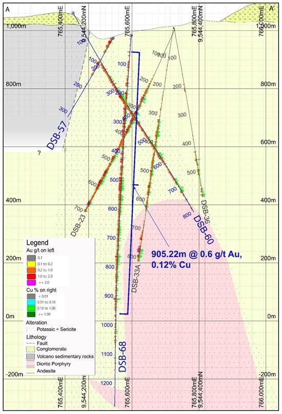
Figure 2: Section A-A’
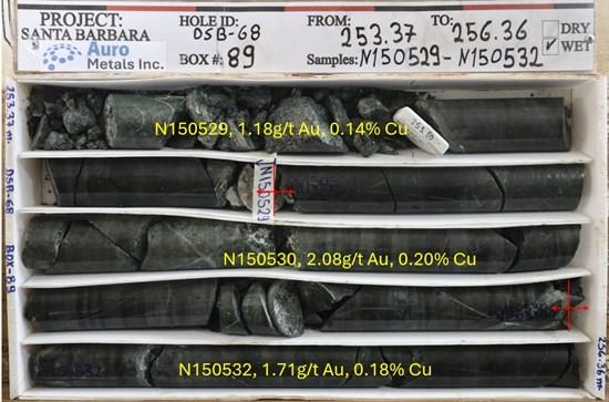
Figure 3: Core photo of DSB-68, Box 89, from 253.37m to 256.36m, mineralized basaltic andesite cut by quartz veining.
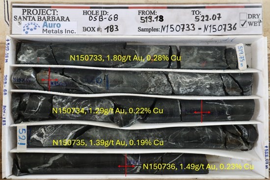
Figure 4: Core photo of DSB-68, Box 183, from 519.18m to 522.07m, mineralized basaltic andesite cut by quartz veining and quartz-carbonate veining.
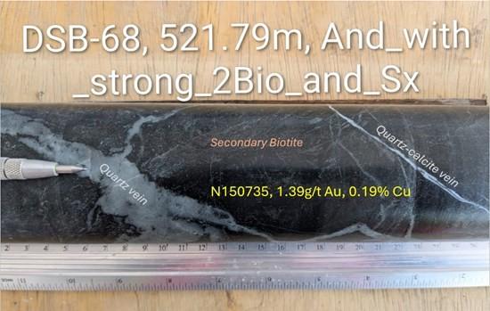
Figure 5: Core photo of DSB-68, depth 521.79m, mineralized basaltic andesite cut by quartz and quartz-calcite veining, with patchy dark brownish secondary biotite (potassic alteration) and dissemination of pyrite and chalcopyrite.
Hole DSB-69 was drilled around 120m to the east of hole DSB-66 in the direction of 260 degrees from north and at a dip angle of -63 degrees to a depth of 490.05m to test the down-dip extension of the mineralization intercepted in hole DSB-66 of which drill results were released on August 18, 2026. This hole intersected 103.05m (from 70.45m to 173.5m) grading 0.53 g/t Au and 0.09% Cu, and 200.55m (from 247.45m to 448m) grading 0.59 g/t Au and 0.08% Cu, including 57.83m (from 266.67m to 324.5m) grading 1.06 g/t Au and 0.10% Cu. The results indicate that mineralization is open in the down-dip direction to the east (Figure 6).
Lithology in the hole is dominated by diorite porphyry in the upper portion to a depth of 243m, whereas the lower portion is mainly basaltic andesite locally intruded by diorite porphyry. Mineralization in forms of both dissemination and narrow veinlets of pyrite and chalcopyrite are closely associated with the intensity of secondary biotite alteration and quartz veining in both rock types of basaltic andesite and diorite porphyry (Figure 7 and Figure 8).
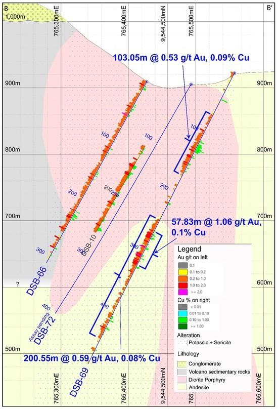
Figure 6: Section B-B’
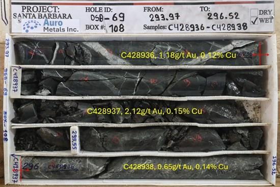
Figure 7: Core photo of DSB-69, Box 108, from 293.97m to 296.52m, mineralized basaltic andesite cut by quartz veining.
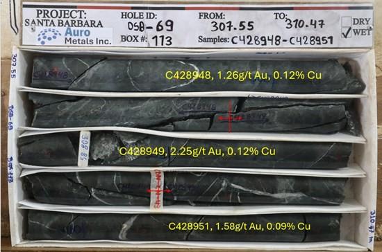
Figure 8: Core photo of DSB-69, Box 113, from 307.55m to 310.47m, mineralized diorite porphyry cut by quartz veining.
Hole DSB-70 was drilled to a depth of 306.6m, in the northern part of Santa Barbara South, in a westerly dipping direction to infill between the historical hole DSB-10 and the 2026 hole DSB-64. It intercepted 262.5m (from 10m to 272.5m) grading 0.71 g/t Au and 0.10% Cu, including 100.45m (from 169.35m to 269.8m) grading 1.01 g/t Au and 0.11% Cu in the lower portion of the hole. Results from this hole indicate mineralization starts from near surface and there is higher grade mineralization hosted in a deeper structure zone of basaltic andesite, diorite porphyry and volcano-sediments (Figure 9).
The upper portion of the hole is dominated by diorite porphyry which is pervasively altered (secondary biotite and sericite) and cut by quartz and quartz-calcite veining with mineralization of dissemination and narrow veinlets of pyrite and chalcopyrite. From a depth of around 100m to 270m there is a structural mixture zone of basaltic andesite, diorite porphyry and volcano-sediments, likely resulting from a combination of hydrothermal hydraulic fracturing and tectonic movement. Mineralization is strong and characterized by rich sulfides of pyrite and chalcopyrite associated with lots of quartz and quartz-calcite veining (Figure 10). From 270m to 306.6m at the end of the hole, lithology changes to mainly volcano-sediments with little mineralization and quartz veining.
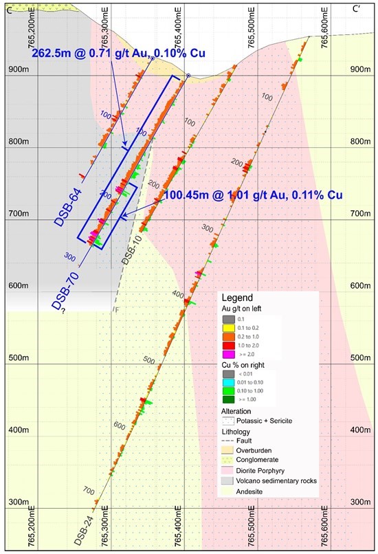
Figure 9: Section C-C’
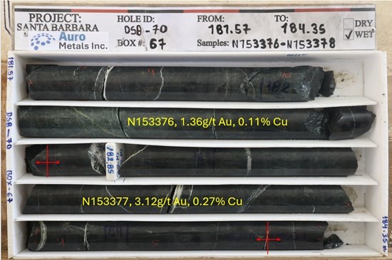
Figure 10: Core photo of DSB-70, Box 67, from 181.57m to 184.35m, mineralized volcano-sediments cut by quartz veining.
Table 2 Summary of Phase I Drillholes of Santa Barbara Gold-Copper Project
| Hole_ID | Easting | Northing | Altitude | Depth_m | Azimuth (°) | Dip (°) | Assay Results |
| DSB-54 | 765463.70 | 9544445.53 | 931.38 | 705.70 | 260 | -82 | complete |
| DSB-55 | 765539.93 | 9544383.21 | 940.76 | 285.50 | 240 | -45 | complete |
| DSB-56 | 765417.68 | 9544434.13 | 960.10 | 274.85 | 260 | -47 | complete |
| DSB-57 | 765541.01 | 9544245.95 | 973.91 | 315.70 | 240 | -60 | complete |
| DSB-58 | 765488.12 | 9544749.44 | 920.64 | 274.80 | 260 | -63 | complete |
| DSB-59 | 765466.41 | 9544269.27 | 1030.67 | 706.55 | 60 | -80 | complete |
| DSB-60 | 765434.27 | 9544155.26 | 1060.67 | 802.65 | 60 | -60 | complete |
| DSB-61 | 765557.28 | 9544184.88 | 990.14 | 720.60 | 236 | -77.5 | complete |
| DSB-62 | 765394.10 | 9544671.12 | 892.48 | 200.00 | 260 | -55 | complete |
| DSB-63 | 765384.50 | 9544605.71 | 891.07 | 253.90 | 260 | -60 | complete |
| DSB-64 | 765356.92 | 9544537.66 | 924.00 | 199.35 | 260 | -60 | complete |
| DSB-65 | 765463.12 | 9544268.74 | 1030.43 | 379.80 | 240 | -70 | complete |
| DSB-66 | 765427.24 | 9544493.67 | 909.15 | 312.15 | 260 | -60 | complete |
| DSB-67 | 765258.71 | 9544399.36 | 1040.33 | 599.00 | 80 | -52 | complete |
| DSB-68 | 765596.09 | 9544275.58 | 983.66 | 1,282.00 | 240 | -85 | complete |
| DSB-69 | 765556.17 | 9544523.38 | 922.05 | 490.05 | 260 | -63 | complete |
| DSB-70 | 765404.89 | 9544551.38 | 900.01 | 306.60 | 260 | -60 | complete |
| DSB-71* | 765256.00 | 9544398.00 | 1039.00 | 745.00 | 80 | -63 | pending |
| DSB-72 | 765494.39 | 9544498.07 | 905.17 | 400.90 | 260 | -60 | pending |
| DSB-73 | 765508.60 | 9544621.44 | 927.45 | 485.65 | 260 | -60 | pending |
| DSB-74 | 765592.12 | 9544640.03 | 961.68 | 856.95 | 260 | -64 | pending |
| DSB-75 | 765550.96 | 9544694.00 | 938.32 | 449.65 | 260 | -65 | pending |
| Total | 11,047.35 |
Notes:
QUALITY ASSURANCE AND QUALITY CONTROL
All samples in respect of the exploration program at the Project discussed in this news release were shipped in securely-sealed bags by a chartered commercial truck, directly from the field to the sample preparation facilities of SGS in Guayaquil, Ecuador for preparation, and to SGS in Lima, Peru for geochemical analysis. SGS is a global leader in inspection, verification, testing, and certification. It is an ISO/IEC 17025 accredited laboratory independent from Auro. All samples go through fire assay (SGS code FAA313) for gold and multi-acid digestion ICP-AES multi-element assay (SGS code ICP40B) for other elements. Certified reference materials, various types of blank samples and duplicate samples are inserted into normal drill core sample sequences prior to delivery to laboratory for preparation and analysis. The overall ratio of quality control samples in sample sequences is around twenty percent.
QUALIFIED PERSON
The scientific and technical information contained in this news release has been reviewed and approved by Alex Zhang, P. Geo., a Director of the Company, who is a Qualified Person for the purposes of National Instrument 43-101 – Standards of Disclosure for Mineral Projects. The Qualified Person has verified the information disclosed herein, including the sampling, preparation, security and analytical procedures underlying such information, and is not aware of any significant risks and uncertainties that could be expected to affect reliability or confidence in the information discussed herein.
ABOUT AURO METALS INC.
Auro Metals Inc. is a mineral exploration company which holds a 100% interest in the Santa Barbara Gold-Copper Project in the Zamora Copper-Gold Belt of southeastern Ecuador. The Santa Barbara Project is a large-scale porphyry system comprising Indicated resources of 29.8 million tonnes grading 0.73 grams per tonne gold and 0.1% copper containing 697,000 ounces gold and 68 million pounds copper, and Inferred resources of 205.7 million tonnes grading 0.52 grams per tonne gold and 0.09% copper containing 3,418,000 ounces gold and 426 million pounds copper. For more detail, see the Company’s mineral resource estimate prepared in accordance with NI 43-101 by SRK Consulting, effective March 23, 2026 which can be found on SEDAR+ and the Company’s website.
Brutus Mining Inc. (CSE: BRU) (FSE: ZI3) is pleased to announce that it has closed its non-brokered ... READ MORE
Jaguar Uranium Corp. (NYSE American: JAGU) is pleased to announce an independent Mineral Resource E... READ MORE
Auro Metals Inc. (TSX-V: AURO) (OTCQB: AURFF), is pleased to announce the assay results of the fina... READ MORE
Endeavour Silver Corp. (NYSE: EXK) (TSX: EDR) is pleased to announce that repairs to the primary bal... READ MORE
Scorpio Gold Corp. (NASDAQ: SGLD) (TSX-V: SGLD) (OTCQB: SRCRF) (FSE: RY9) is pleased to announce re... READ MORE


