


Arizona Metals Corp. (TSX: AMC) (OTCQX: AZMCF) is pleased to announce assay results from five drill holes in the Kay2 Zone at the Kay project in Arizona.
To date, drilling in the Kay2 Zone has demonstrated dimensions of 100 m along strike and 140 m vertically. Drilling shows good continuity in mineralization in the Kay2 Zone and adjacent mineralization in the main Kay deposit to the south. The Kay2 Zone is located approximately 100 m north of previously drilled mineralization in the Kay deposit.
Duncan Middlemiss, President and CEO of Arizona Metals, comments: “We are encouraged by the latest drill results from the Kay2 Zone, which continue to demonstrate significant expansion potential. The intercepts show substantial thicknesses, consistent grades, and strong continuity—key indicators of a robust mineralized system. These results reinforce our confidence in the Kay2 Zone and support our view that these results will contribute to the overall tonnage of the Kay deposit. We believe this will be clearly reflected in the updated mineral resource estimate, which remains on track for release in the second quarter of 2025.”
The Company has also received approval for one additional drill pad from the Bureau of Land Management under the existing Notice of Intent to Explore permit. This drill pad provides additional opportunities to test the Kay North Extension target where the Kay mineralized horizon continues north from the Kay deposit. One drill hole in the Kay2 Zone, KM-25-176, encountered no significant assays (Table 1). Deep drill hole KM-25-177, targeted at the depth extension of the main Kay deposit, was lost before reaching the target depth due to difficult drilling. With the completion of recent drill holes, Arizona Metals has drilled a total of 133,000 meters on the property.
Table 1. Results of Phase 3 Drill Program at the Kay Project, Yavapai County, Arizona announced in this news release.
| Analyzed Grade
|
Analyzed Metal Equivalent |
Metal Equivalent | ||||||||||||
| Hole ID | From m |
To m | Length m |
Cu % |
Au g/t |
Zn % |
Ag g/t |
Pb % |
CuEq % |
AuEq g/t |
ZnEq % |
CuEq % |
AuEq g/t |
ZnEq % |
| KM-25-176 | no significant assays | |||||||||||||
| KM-25-177 | lost before reaching target depth | |||||||||||||
| KM-25-178 | 605.9 | 607.8 | 1.8 | 0.01 | 2.21 | 0.57 | 26.0 | 0.66 | 1.93 | 3.17 | 5.02 | 1.44 | 2.35 | 3.74 |
| KM-25-178 | 614.2 | 632.8 | 18.6 | 1.15 | 1.23 | 1.40 | 4.8 | 0.10 | 2.49 | 4.09 | 6.49 | 2.13 | 3.50 | 5.55 |
| including | 623.6 | 626.5 | 2.9 | 0.28 | 3.29 | 6.42 | 7.4 | 0.50 | 4.93 | 8.08 | 12.82 | 4.08 | 6.69 | 10.61 |
| KM-25-178 | 685.7 | 694.0 | 8.4 | 1.67 | 0.65 | 0.05 | 6.9 | 0.02 | 2.15 | 3.52 | 5.58 | 1.89 | 3.10 | 4.92 |
| including | 686.9 | 688.1 | 1.2 | 5.08 | 2.88 | 0.07 | 21.6 | 0.02 | 7.04 | 11.54 | 18.31 | 6.11 | 10.01 | 15.88 |
| KM-25-179 | 607.2 | 639.2 | 32.0 | 0.94 | 1.37 | 4.25 | 27.2 | 0.56 | 3.75 | 6.14 | 9.75 | 3.23 | 5.29 | 8.40 |
| including | 609.5 | 611.7 | 2.3 | 0.43 | 5.44 | 12.10 | 41.1 | 0.30 | 8.79 | 14.41 | 22.87 | 7.30 | 11.96 | 18.98 |
| including | 619.8 | 625.9 | 6.1 | 0.65 | 2.73 | 12.19 | 35.9 | 1.86 | 7.70 | 12.62 | 20.03 | 6.66 | 10.91 | 17.32 |
| KM-25-179 | 664.5 | 666.0 | 1.5 | 6.60 | 0.14 | 0.04 | 4.0 | 0.04 | 6.74 | 11.04 | 17.52 | 6.24 | 10.23 | 16.23 |
| KM-25-179 | 687.9 | 695.6 | 7.6 | 0.81 | 0.13 | 0.22 | 9.4 | 0.05 | 1.06 | 1.74 | 2.75 | 0.95 | 1.56 | 2.47 |
| KM-25-180 | 657.6 | 702.1 | 44.5 | 0.67 | 1.68 | 2.78 | 18.7 | 0.12 | 2.94 | 4.82 | 7.66 | 2.46 | 4.03 | 6.39 |
| including | 663.2 | 672.7 | 9.5 | 0.43 | 5.37 | 7.14 | 59.2 | 0.35 | 7.00 | 11.47 | 18.20 | 5.63 | 9.22 | 14.63 |
| including | 671.5 | 672.4 | 0.9 | 0.99 | 18.85 | 8.20 | 191.0 | 1.40 | 17.47 | 28.63 | 45.43 | 13.24 | 21.70 | 34.44 |
| The true width of mineralization is estimated to be 50% to 99% of reported core width, with an average of 76%. (2) Assumptions used in USD for the copper and gold metal equivalent calculations were metal prices of $4.63/lb Copper, $1937/oz Gold, $25.20/oz Silver, $1.78/lb Zinc, and $1.02/lb Pb. Metal Equivalent calculations used assumed metal recoveries, based on a preliminary review of historic data by SRK and ProcessIQ, were 93% for copper, 92% for zinc, 90% for lead, 72% silver, and 70% for gold. The following equation was used to calculate copper equivalence: CuEq = Copper (%) (93% rec.) + (Gold (g/t) x 0.61)(70% rec.) + (Silver (g/t) x 0.0079)(72% rec.) + (Zinc (%) x 0.3844)(92% rec.) + (Lead (%) x 0.2203)(90% rec.). The following equation was used to calculate gold equivalence: AuEq = Gold (g/t)(70% rec.) + (Copper (%) x 1.638)(93% rec.) + (Silver (g/t) x 0.01291)(72% rec.) + (Zinc (%) x 0.6299)(92% rec.) +(Lead (%) x 0.3609)(90% rec.). Analyzed metal equivalent calculations are reported for illustrative purposes only. The metal chosen for reporting on an equivalent basis is the one that contributes the most dollar value after accounting for assumed recoveries. | ||||||||||||||
About Arizona Metals Corp
Arizona Metals Corp owns 100% of the Kay Project in Yavapai County, which is located on 1669 acres of patented and BLM mining claims and 193 acres of private land that are not subject to any royalties. An historic estimate by Exxon Minerals in 1982 reported a “proven and probable reserve of 6.4 million short tons at a grade of 2.2% copper, 2.8 g/t gold, 3.03% zinc, and 55 g/t silver.” The historic estimate at the Kay Mine Project was reported by Exxon Minerals in 1982. (Fellows, M.L., 1982, Kay Mine massive sulphide deposit: Internal report prepared for Exxon Minerals Company)
The Kay Project’s historic estimate has not been verified as a current mineral resource. None of the key assumptions, parameters, and methods used to prepare the historic estimate were reported, and no resource categories were used. Significant data compilation, re-drilling and data verification may be required by a Qualified Person before the historic estimate can be verified and upgraded to be a current mineral resource. A Qualified Person has not done sufficient work to classify it as a current mineral resource, and Arizona Metals is not treating the historic estimate as a current mineral resource.
The Kay Project is a steeply dipping VMS deposit that has been defined from a depth of 60 m to at least 900 m. It is open for expansion on strike and at depth.
The Company also owns 100% of the Sugarloaf Peak Project, in La Paz County, which is located on 4,400 acres of BLM claims. The Sugarloaf Peak Project is a heap-leach, open-pit target and has a historic estimate of “100 million tons containing 1.5 million ounces gold” at a grade of 0.5 g/t (Dausinger, N.E., 1983, Phase 1 Drill Program and Evaluation of Gold-Silver Potential, Sugarloaf Peak Project, Quartzsite, Arizona: Report for Westworld Inc.)
The historic estimate at the Sugarloaf Peak Project was reported by Westworld Resources in 1983. The historic estimate has not been verified as a current mineral resource. None of the key assumptions, parameters, and methods used to prepare the historic estimate were reported, and no resource categories were used. Significant data compilation, re-drilling and data verification may be required by a Qualified Person before the historic estimate can be verified and upgraded to a current mineral resource. A Qualified Person has not done sufficient work to classify it as a current mineral resource, and Arizona Metals is not treating the historic estimate as a current mineral resource.
Qualified Person and Quality Assurance/Quality Control
All of Arizona Metals’ drill sample assay results have been independently monitored through a quality assurance/quality control protocol which includes the insertion of blind standard reference materials and blanks at regular intervals. Logging and sampling were completed at Arizona Metals’ core handling facilities located in Phoenix and Black Canyon City, Arizona. Drill core was diamond sawn on site and half drill-core samples were securely transported to ALS Laboratories’ sample preparation facility in Tucson, Arizona. Sample pulps were sent to ALS’s labs in Vancouver, Canada, and Reno, Nevada, for analysis.
Gold content was determined by fire assay of a 30-gram charge with ICP finish (ALS method Au-AA23). Silver and 32 other elements were analyzed by ICP methods with four-acid digestion (ALS method ME-ICP61a). Over-limit samples for Au, Ag, Cu, and Zn were determined by ore-grade analyses Au-GRA21, Ag-OG62, Cu-OG62, and Zn-OG62, respectively.
ALS Laboratories is independent of Arizona Metals Corp. and its Vancouver and Reno facilities are ISO 17025 accredited. ALS also performed its own internal QA/QC procedures to assure the accuracy and integrity of results. Parameters for ALS’ internal and Arizona Metals’ external blind quality control samples were acceptable for the samples analyzed. Arizona Metals is not aware of any drilling, sampling, recovery, or other factors that could materially affect the accuracy or reliability of the data referred to herein.
The qualified person who reviewed and approved the technical disclosure in this release is David Smith, CPG, a qualified person as defined in National Instrument43-101 – Standards of Disclosure for Mineral Projects. Mr. Smith supervised the preparation of the scientific and technical information that forms the basis for this news release and has reviewed and approved the disclosure herein. Mr. Smith is the Vice-President, Exploration of the Company. Mr. Smith supervised the drill program and verified the data disclosed, including sampling, analytical and QA/QC data, underlying the technical information in this news release, including reviewing the reports of ALS, methodologies, results, and all procedures undertaken for quality assurance and quality control in a manner consistent with industry practice, and all matters were consistent and accurate according to his professional judgement. There were no limitations on the verification process
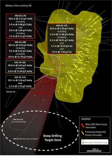
Figure 1. Oblique section looking northeast, displaying new drill holes reported in this release. See Table 1 for additional details. The true width of mineralization in this area is yet to be determined. See Table 1 for constituent elements, grades, metals prices and recovery assumptions used for AuEq g/t and CuEq % calculations. Analyzed Metal Equivalent calculations are reported for illustrative purposes only. (CNW Group/Arizona Metals Corp.)
Hudbay Minerals Inc. (TSX:HBM) (NYSE: HBM) today released its ann... READ MORE
Strategic acquisition of an established operating gold mine, loca... READ MORE
Cerro de Pasco Resources Inc. (TSX-V: CDPR) (OTCQB: GPPRF) (FRA: ... READ MORE
The Garneau Titanium Project Features Ilmenite-Rich Boulder with ... READ MORE
ValOre Metals Corp. (TSX‐V: VO) (OTCQB: KVLQF) (Frankfurt: KEQ0... READ MORE


