


Amex Exploration Inc. (TSX-V: AMX) (FSE: MX0) (OTCQX: AMXEF) is pleased to announce assay results from a geomechanical drill program conducted on the Champagne Zone as part of its ongoing Phase 1 Feasibility Study on the Perron Project, located in northwestern Abitibi, Quebec. The three-hole drill program was designed to conduct rock mass characterization of the main lithological units within the immediate area of the Champagne Zone. Hole PEGT-25-001 returned 213.11 g/t Au over 3.75 m, which included 1106.50 g/t Au over 0.50 m, the latter of which represents Amex’s highest ever grade assay to date on the property. While the main purpose of the program was focused on rock mechanics in the areas envisaged for toll mining of the Champagne Zone (see PEA press release dated September 4, 2025 for mine plan details), the Company is encouraged to see the robustness and continuity of high-grade mineralization that the zone continues to display.
Champagne Zone Geomechanical Drill Result Highlights:
See Figure 1 for location of the geomechanical drill holes, Figure 2 for a longitudinal of the Champagne Zone, Figure 3 for images of visible gold and Figure 4 for details of the geomechanical program design. Table 1 contains assays results and Table 2 displays drill hole coordinates.
Aaron Stone, P.Geo, Vice President Exploration of Amex Exploration commented, “The geomechanical program was designed with the primary goal of gathering information on all aspects of the rock mechanics surrounding the high-grade Champagne Zone, which is envisaged for toll-milling as described by our latest PEA study. These holes were designed to best intercept the important structures within and surrounding the Champagne Zone and not necessarily placed in important zones of mineralization, so the fact that PEGT-25-001 has produced the highest-grade assay to date on the property, is exceptional. It is also important to note that, as we had ample analytical data in the areas surrounding the geomechanical drilling, the decision was made to send the whole core for analysis. A whole core analysis provides a truer representation of the mineralization, so it is extremely encouraging to observe the robustness of high-grade that the zone continues to display.”
Victor Cantore, CEO and President of Amex Exploration added, “The Feasibility Study for Phase 1 of operations at Perron is advancing well with the completion of the geomechanical drilling program. Initial results from the program show good rock mass quality in the rhyolite that hosts the Champagne Zone, ideal for underground mining. The critical data collected will guide stope dimensions for Phase 1 operations, which will in turn decide the mining rate achievable for the project. Additional important studies surrounding hydrogeology, geochemical analysis of ore and waste material and environmental studies, among others, are also progressing well. Today’s high-grade assay results further confirm our confidence in the project and the exceptional continuity of mineralization within the Champagne Zone.”
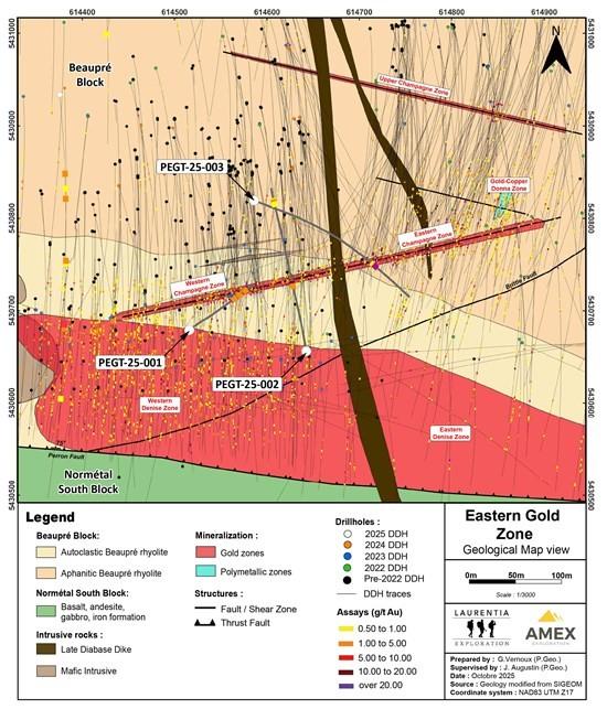
Figure 1: Geological map of the Champagne Zone displaying the drill holes completed for the geomechanical program.
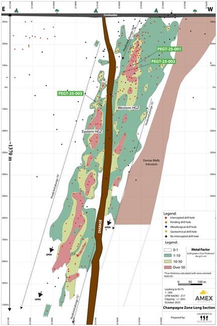
Figure 2: Longitudinal of the Champagne Zone looking to the south displaying the pierce points of the geomechanical holes.
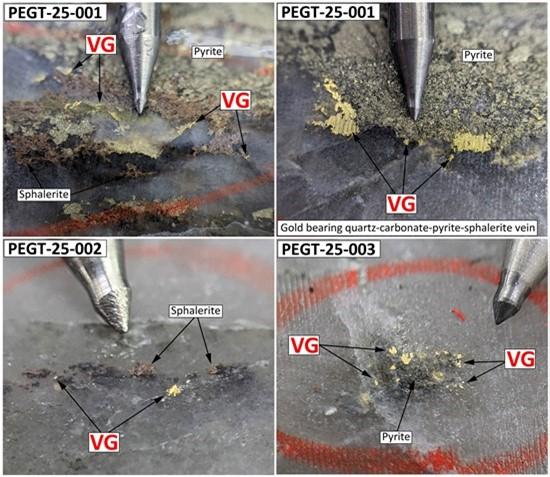
Figure 3: Photos of visible gold in the Champagne Zone from drill holes PEGT-25-001, 002 and 003. Mineralization is represented by gold bearing quartz-carbonate-sulfide veins with visible gold hosted in the aphanitic Beaupré rhyolite. Abbreviation: VG – Visible Gold.
Description of the Geomechanical Program
The main objectives of the geomechanical program were to gather as much information as possible surrounding all aspects of rock mechanics of the Champagne Zone. This includes all characteristics of important joint sets and fractures in the area across the multiple lithologies encountered as well as their mechanical strength.
PEGT-25-001 was designed to intercept the western portion of the planned stoping area, drilling to the north-east. The hole transected the S1 fault.
PEGT-25-002 was designed to intercept the central portion of the planned stoping area, drilling to the north. The hole was drilled through the gabbro of the Champagne Zone, in the planned development area, and also reached the S2 Fault.
PEGT-25-003 was designed to intercept the eastern portion of the planned stoping area, drilling to the south-east. The hole started in the shallow portions of the planned development area and crosses the I3B (diabase) intrusion as well as the intersection of the Main and S1 Faults.
The orientation of the 2025 geomechanical drillholes was varied to capture data in all portions of the stereonet, as best as possible.
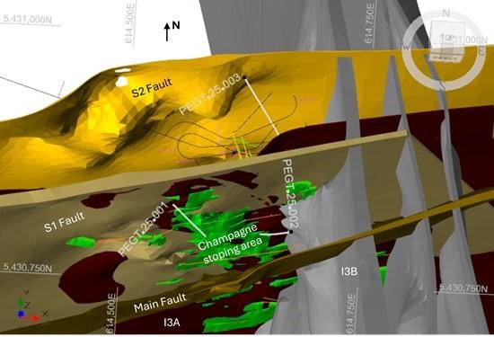
Figure 4: Location of drillholes from the 2025 geomechanical program. Champagne Zone stoping area is displayed as green.
Discussion of Geomechanical Results
Rock mass classification of the rhyolite was established. Preliminary analyses suggest a mode Q’ value of 11. There are occasional highly fractured intervals at the contact (northern/southern) of the gabbro (I3A) and the rhyolite (V1B). This is not systematic; in most cases the thickness of these fractured intervals appears to be under 1 m. The Main Fault appears to be associated with highly fractured ground over a thickness of a few meters.
The strength testing results suggest that the rock mass is competent and rigid. The average UCS in the rhyolite is 116 MPa and the average Young’s modulus is 71 GPa. There is a strong contrast between the rhyolite and the intrusives. The average UCS in the I3B (diabase) dyke crossing the stoping area is 334 MPa and the average Young’s modulus is 100 GPa. Mitigation measures will be integrated to the mining sequence to minimize excessive stress concentration in the most rigid units.
Televiewer surveying was also conducted in the three geomechanical drillholes but also in 17 other holes drilled in 2019, 2020 and 2021. A dominant north-south trending sub-vertical joint set was identified, as well as a north-west – south-east steeply dipping set. A sub-vertical north-east – south-west joint set was also identified. A horizontal joint set is visible at shallow depths (less than 200 meters).
Results from the rock mass characterization will be used as inputs for rock mechanic assessments in support of the mine design. They will also feed a numerical stress model from which geomechanical risk profiles of the mining sequence will be established.
Table 1: Assay results from the geomechanical drill program conducted on the Champagne Zone.
| Hole ID | From (m) | To (m) | Core Length (m) | True Thickness (m) | Au (g/t) | Ag (g/t) | Vertical Depth (m) | MF1* (g/t Au*m) |
MF2* (g/t Au*m) |
Zone |
| PEGT-25-001 | 227.50 | 260.30 | 32.80 | 2.59 | 25.19 | 1.99 | ~200 to ~245 | 826.09 | 65.23 | Western Champagne Zone |
| Including | 227.50 | 231.25 | 3.75 | 0.30 | 213.11 | 15.68 | 799.17 | 63.93 | ||
| Including | 229.00 | 229.50 | 0.50 | 0.04 | 1106.50 | 101.30 | 553.25 | 44.26 | ||
| Including | 252.50 | 260.30 | 7.80 | 0.62 | 3.36 | 0.46 | 26.21 | 2.08 | ||
| And | 290.90 | 291.50 | 0.60 | – | 1.38 | 0.10 | ~250 | 0.83 | – | Undefined Gold Zone |
| PEGT-25-002 | 272.95 | 284.80 | 11.85 | 2.73 | 0.74 | 0.39 | ~260 to ~275 | 8.80 | 2.03 | Western Champagne Zone |
| Including | 272.95 | 273.50 | 0.55 | 0.13 | 4.48 | 2.70 | 2.46 | 0.58 | ||
| Including | 283.20 | 284.80 | 1.60 | 0.37 | 3.88 | 1.04 | 6.21 | 1.44 | ||
| And | 576.90 | 577.40 | 0.50 | – | 0.52 | 0.70 | ~555 | 0.26 | – | Undefined Gold Zone |
| And | 584.70 | 585.20 | 0.50 | – | 2.57 | 0.30 | ~560 | 1.28 | – | |
| And | 588.90 | 589.60 | 0.70 | – | 0.97 | 0.20 | ~565 | 0.68 | – | |
| PEGT-25-003 | 447.90 | 459.60 | 11.70 | 3.23 | 3.59 | 0.57 | ~420 to ~430 | 42.01 | 11.60 | Eastern Champagne Zone |
| Including | 447.90 | 448.55 | 0.65 | 0.18 | 0.95 | 0.60 | 0.62 | 0.17 | ||
| Including | 458.35 | 459.05 | 0.70 | 0.19 | 58.28 | 6.60 | 40.80 | 11.07 | ||
| *Metal factor 1 is defined as gold grade multiplied by core length (g/t Au*m) | ||||||||||
| *Metal factor 2 is defined as gold grade multiplied by true thickness (g/t Au*m) | ||||||||||
Note: The geomechanical holes were not drilled perpendicular to the zone and were planned to best intercept and gather information on important structures. Estimated true thicknesses are displayed alongside core length for reference. MF = metal factor. MF1 = core length metal factor. MF2 = true length metal factor.
Table 2: Drillhole coordinates for today’s results.
| Hole ID | Azimut (°) | Dip (°) | From (m) | To (m) | Length (m) | Easting (m) | Northing (m) | Elevation (m) |
| PEGT-25-001 | 50 | -75 | 0 | 330 | 330 | 614516 | 5430679 | 341 |
| PEGT-25-002 | 350 | -75 | 0 | 630 | 630 | 614643 | 5430656 | 342 |
| PEGT-25-003 | 110 | -70 | 0 | 613 | 613 | 614586 | 5430819 | 345 |
Qualified Person and QA&QC
Jérôme Augustin P.Geo. Ph.D., (OGQ 2134), an Independent Qualified Person as defined by Canadian NI 43-101 standards, has reviewed and approved the geological information reported in this news release. The drilling campaign and the quality control program have been planned and supervised by Jérôme Augustin. Core logging and sampling were completed by Laurentia Exploration.
The quality assurance and quality control protocols include insertion of blank or standard samples every 10 samples on average, in addition to the regular insertion of blank, duplicate, and standard samples accredited by Laboratoire Expert and ALS Canada Ltd, during the analytical process.
For all analyses targeting gold mineralization, gold values are estimated by fire assay with finish by atomic absorption. Values over 3 ppm Au are reanalyzed by fire assay with finish by gravimetry by Laboratoire Expert Inc, Rouyn-Noranda. Samples containing visible gold mineralization are analyzed by metallic sieve. For additional quality assurance and quality control, all samples were crushed to 90% less than 2 mm prior to pulverization, in order to homogenize samples which may contain coarse gold.
The Qualified Person has not completed sufficient work to verify the historical information on the Property or neighbouring projects, particularly in regards to historical drill results. However, the Qualified Person believes that drilling and analytical results were completed to industry standard practices. The information provides an indication of the exploration potential of the Property but may not be representative of expected results.
About Amex
Amex Exploration Inc. has made significant high-grade gold discoveries, along with copper-rich volcanogenic massive sulphide (VMS) zones, at its 100%-owned Perron Gold Project, located approximately 110 kilometres north of Rouyn-Noranda, Quebec. On June 25, 2025, the MRNF converted the Perron claims from 117 to 135 contiguous claims, maintaining the same surface area of 45.18 km². The project hosts both bulk-tonnage and high-grade gold mineralization styles.
When combined with the adjacent Perron West Project, which includes 48 claims (17.37 km²) in Quebec and 35 claims (134.55 km²) in Ontario, the consolidated land package spans a district-scale 197.52 km². This extensive property lies within highly prospective geology favourable for both high-grade gold and VMS mineralization.
The Project benefits from excellent infrastructure: it is accessible by a year-round road, located just 20 minutes from an airport, and approximately 8 km from the Town of Normétal. It is also in close proximity to several process plants owned by major gold producers.
Hudbay Minerals Inc. (TSX:HBM) (NYSE: HBM) today released its ann... READ MORE
Strategic acquisition of an established operating gold mine, loca... READ MORE
Cerro de Pasco Resources Inc. (TSX-V: CDPR) (OTCQB: GPPRF) (FRA: ... READ MORE
The Garneau Titanium Project Features Ilmenite-Rich Boulder with ... READ MORE
ValOre Metals Corp. (TSX‐V: VO) (OTCQB: KVLQF) (Frankfurt: KEQ0... READ MORE


