


![]()
1911 Gold Corporation (TSX-V: AUMB) (OTCBB: AUMBF) (FRA: 2KY) is pleased to announce new assay results from the surface drill program at the Company’s wholly-owned operational and fully permitted True North Gold Project, centrally located within the Company’s 100%-owned Rice Lake Gold property, southeast Manitoba, Canada. The latest assay results are from five (5) drill holes for 1,867 metres targeting the San Antonio West target.
Drilling* Highlights:
| * All drill results are quoted as downhole drill lengths, and downhole depth. |
“San Antonio West continues to deliver some of the best near-mine exploration results we’ve seen at True North,” stated Shaun Heinrichs, President and CEO. “These high-grade intercepts demonstrate the strength of the True North mineralized system and highlights the continued opportunity to outline new zones of mineralization adjacent to existing infrastructure. With the transition to underground drilling, we will accelerate resource growth across multiple target areas building towards a sustainable restart of operations.”
1911 Gold has now completed seventy-five surface drill holes, for a total of 20,398 m of drilling as part of the 2025 surface exploration drill program. The 2025 Surface Drill Program focused on new targets defined by favourable host rocks and mineralized structural settings within the True North Mine footprint, also supported by significant historical drill intercepts that were close to surface and existing infrastructure. The most recent phase of the program consisted of two drill rigs targeting the down-dip extensions of mineralization at the new high-grade San Antonio Southeast and SAM W target areas, as well as the newly identified Shore target. The surface drilling program was completed on September 20, 2025, and these are the last assay results being reported for the program. Project activities have now shifted to underground exploration, resource expansion and resource delineation drilling. Underground drilling within the True North Mine commenced on October 1, 2025, with one drill rig on Level 16 (695 m below surface) and a second drill rig added on November 6, 2025.
| *Along the Cartwright South shear zone projected to vertical, San Antonio drifts and shafts projected up to 250 m from the south-east |
| **For other drill results see press release dated June 10, 2025 (1911 Gold intersects up to 58.66 g/t Gold over 1.40 m on San Antonio West Zone at True North); April 30, 2025 (1911 Gold intersects 62.40 g/t Au over 1.00 m on San Antonio West Zone at True North) and February 4, 2025 (1911 Gold intersects 8.42 g/t Gold over 0.91 m and 7.23 g/t Gold over 1.05 m in Drilling at True North). |
|
Table 1: Select Significant Drill Hole Assay Results |
|||||
| Target Area
(name) |
Drill Hole
(number) |
From
(m) |
To
(m) |
Interval
(m) |
Au
(g/t) |
| Annex | TN-25-061 | 247.30 | 247.80 | 0.50 | 10.00 |
| 250.00 | 251.00 | 1.00 | 4.23 | ||
| 293.70 | 296.30 | 2.60 | 8.75 | ||
| Including | 295.30 | 296.30 | 1.00 | 18.00 | |
| Annex | TN-25-064 | 271.60 | 274.70 | 3.10 | 2.94 |
| Including | 273.70 | 274.70 | 1.00 | 6.71 | |
| SAM W | TN-25-064 | 490.00 | 492.60 | 2.60 | 24.83 |
| Including | 490.00 | 491.00 | 1.00 | 46.00 | |
| Including | 490.00 | 490.50 | 0.50 | 63.20 | |
| and | 490.50 | 491.00 | 0.50 | 28.80 | |
| and | 492.10 | 492.60 | 0.50 | 32.40 | |
| Annex | TN-25-067 | 272.50 | 275.00 | 2.50 | 5.23 |
| Including | 273.00 | 275.00 | 2.00 | 5.76 | |
| and | 274.50 | 275.00 | 0.50 | 9.18 | |
| SAM W | TN-25-067 | 467.60 | 473.40 | 5.80 | 4.04 |
| Including | 467.60 | 468.10 | 0.50 | 23.90 | |
| and | 472.90 | 473.40 | 0.50 | 6.12 | |
| 497.20 | 497.70 | 0.50 | 4.88 | ||
| Annex | TN-25-071 | 274.10 | 274.60 | 0.50 | 2.89 |
| 307.60 | 309.00 | 1.40 | 6.73 | ||
| Including | 307.60 | 308.50 | 0.90 | 7.47 | |
| 313.70 | 314.30 | 0.60 | 2.34 | ||
| 317.90 | 318.50 | 0.60 | 3.88 | ||
| 322.00 | 322.50 | 0.50 | 5.01 | ||
| SAM W | TN-25-071 | 473.50 | 474.30 | 0.80 | 12.80 |
| 1) | Intercepts above a cut-off grade of 2.25 g/t Au | ||||
| 2) | Maximum of 2.50 m internal dilution and no top capping applied | ||||
| 3) | Intervals represent drill core length and are considered to represent 60% to 90% of true widths | ||||
| 4) | Full Significant Assay Results included in Table 2 | ||||
| 5) | Drill hole Information included in Table 3 | ||||
San Antonio West Target: Discussion of Results
Drilling completed to date has confirmed the extensions of gold mineralization within the SAM gabbro to over 600 m northwest of the historically mined San Antonio zone, covering an area 400 m long and up to 630 m in depth. Twenty-six surface drill holes, for a total of 6,087 m, were drilled on the SAM W target area as part of the 2025 program. The results of five (5) drill holes for 1,867 m are included in this press release, of which two drill holes, TN-25-061 (311 m downhole depth) and TN-25-071A (30 m downhole depth), did not reach target depths and were abandoned due to hole deviation.
Drilling on the SAM W target confirmed the presence of a vein system parallel to the historical San Antonio ore body, which shares the same geology, alteration, and mineralization characteristics. The mineralized intercepts are characterized by quartz-carbonate shear veins and vein breccias with sericite, chlorite alteration and pyrite disseminated and in veinlets developed in association with east and northwest trending shear zone corridors.
Drill hole TN-25-064 tested the down-dip extensions of the modelled SAM W target area. Drilling successfully intercepted high-grade gold mineralization with the best intercept of 2.60 m @ 24.83 g/t Au (at 490.00 m downhole depth).
Drill hole TN-25-067 tested the 100 m down-dip extension of gold mineralization intersected in hole TN-25-058 (0.50 m @ 10.40 g/t Au), and intersected two distinct gold mineralized veins including 0.50 m @ 10.40 g/t Au, see press release dated June 10, 2025 (1911 Gold Intersects up to 58.66 g/t Au over 1.40 m on San Antonio West zone at True North).
Drill hole TN-25-71 was designed to test 100 m west of gold mineralization intersected in drill hole TN-25-060 (2.60 m @ 24.83 g/t Au), and intersected 0.80 m @ 12.80 g/t Au, see press release dated June 10, 2025 (1911 Gold Intersects up to 58.66 g/t Au over 1.40 m on San Antonio West zone at True North).
Annex Target: Discussion of Results
Drilling completed on the Annex target defined high-grade gold mineralization within a dacitic volcaniclastic unit. The gold mineralization is associated with well-developed quartz shear veins and vein breccias within a carbonate, sericite +/- chlorite alteration assemblage and disseminated and veinlet-hosted pyrite and occasionally specs of native gold.
Drill hole TN-25-061 intercepted 0.50 m @ 10.00 g/t Au (at 247.30 m downhole depth) and 2.60 m @ 8.75 g/t Au (at 293.70 m downhole depth), including 1.00 m @ 18.00 g/t Au (at 295.30 m downhole depth).
Drill hole TN-25-064 intercepted 3.10 m @ 2.94 g/t Au (at 271.60 m downhole depth), including 1.00 m @ 6.71 g/t Au (at 273.70 m downhole depth).
Drill hole TN-25-067 intercepted 2.50 m @ 5.23 g/t Au (at 272.50 m downhole depth), including 2.00 m @ 5.76 g/t Au (at 273.70 m downhole depth), and 0.50 m @ 9.18 g/t Au (at 274.50 m downhole depth).
Drill hole TN-25-071 intercepted 1.40 m @ 6.73 g/t Au (at 307.60 m downhole depth), including 0.90 m @ 7.47 g/t Au.
The high-grade nature and width of the drill intercepts and the preliminary size of the area drilled (120 m on strike and 160 m vertically and open up and down dip) represent an additional emerging target within the mine footprint. Upon modelling, this area could be further drilled from surface to define a potential new ore source in close proximity of the True North Mine infrastructure.
San Antonio West Target
The SAM W target is located west of the historically mined San Antonio zone within the True North Mine. The SAM W target occurs within the gabbro of the San Antonio mafic unit and the intersection with the Cartwright South mineralized shear zone. The SAM gabbro hosts the majority of the known gold mineralization within the True North Mine and historically produced 1,309,351 ounces Au at an average grade of 9.33 g/t Au from San Antonio (see technical report entitled “NI 43-101 Technical Report on the True North Gold Project, Bissett, Manitoba, Canada, dated December 23. 2024).
Annex Target
The Annex target is located 300 m east of the Cartwright Zone and 1 kilometre (“km“) northwest of the Hinge deposit, and was first intersected in a 2012 and 2013 surface exploration drilling program. The target is located at the intersection of the Cartwright South shear zone with a dacitic volcanoclastic unit, potentially the northwest extension of the host unit of the Hinge deposit, and covers an area with a 120 m east-west strike length by 160 m vertically, and is open both along strike and at depth. Additional interpretation is ongoing to model the extent of the mineralized zone to assess up-side potential.
| *Historic drill holes referenced on Table 4 and 5 below |
Next Steps
With the latest phase of surface drilling within the mine lease completed in late September, the Company has shifted its focus to an expanded underground drill campaign within the True North Mine footprint. Two (2) underground drill rigs are currently active on Level 16, an area that provides multiple favourable drill stations and immediate access to high-priority targets. Underground drilling is designed to continue testing the down-dip extensions of the SAM W, SAM SE and Shore discoveries, as well as evaluating several newly defined exploration targets (see press release dated September 25, 2025). The program will also include delineation drilling of two test mining areas accessible from Level 16 and drill testing the extensions of the current resource.
Rehabilitation work will also commence in two key areas over the coming months: the L13 deposit area, accessed by a ramp from the Hinge decline, and Level 6, a previously unsurveyed level located 262 m below surface, extending northwest from the A Shaft of the historical San Antonio workings. The L13 area will provide improved access to drill the down-dip extensions of the SAM SE target, while rehabilitation on Level 6 will support continued drilling of the SAM W target and potential drilling of the Cartwright Zone to the west, an area hosting a mineral resource open-at-depth. Additional surface drilling is currently being planned to continue testing the SAM W and Shore targets over the winter.
Concurrently, the Company is advancing permitting for a 2,200 m surface drill program at Ogama-Rockland, a near-surface target with a high-grade NI 43-101 mineral resource, located 35 km southeast of the True North complex (see Technical Report dated November 15, 2013, “A Technical Review of the Ogama-Rockland Deposit on the Rice Lake Property, Manitoba, Canada,” prepared by Watts, Griffis and McOuat). The Company expects to receive approval to commence drilling in the coming weeks, which would allow the program to begin before year-end.
|
Table 2: True North; Select Drill Hole Assays |
|||||
| Target Area
(name) |
Drill Hole
(number) |
From
(m) |
To
(m) |
Interval
(m) |
Au
(g/t) |
| Annex | TN-25-061 | 247.30 | 247.80 | 0.50 | 10.00 |
| 249.00 | 250.00 | 1.00 | 0.59 | ||
| 250.00 | 251.00 | 1.00 | 4.23 | ||
| 251.00 | 253.60 | 2.60 | 1.84 | ||
| 261.60 | 262.20 | 0.60 | 0.55 | ||
| 288.70 | 289.20 | 0.50 | 1.35 | ||
| 293.70 | 296.30 | 2.60 | 8.75 | ||
| Including | 295.30 | 296.30 | 1.00 | 18.00 | |
| 297.00 | 297.50 | 0.50 | 0.51 | ||
| 300.20 | 300.70 | 0.50 | 0.71 | ||
| 301.90 | 303.00 | 1.10 | 0.65 | ||
| Annex | TN-25-064 | 260.30 | 264.00 | 3.70 | 1.02 |
| 271.60 | 274.70 | 3.10 | 2.94 | ||
| Including | 273.70 | 274.70 | 1.00 | 6.71 | |
| 311.30 | 312.40 | 1.10 | 0.66 | ||
| 315.50 | 317.30 | 1.80 | 0.96 | ||
| 483.90 | 485.90 | 2.00 | 1.08 | ||
| 487.00 | 488.00 | 1.00 | 1.93 | ||
| SAM West | TN-25-064 | 490.00 | 492.60 | 2.60 | 24.83 |
| Including | 490.00 | 491.00 | 1.00 | 46.00 | |
| Including | 490.00 | 490.50 | 0.50 | 63.20 | |
| and | 490.50 | 491.00 | 0.50 | 28.80 | |
| and | 492.10 | 492.60 | 0.50 | 32.40 | |
| 492.60 | 496.50 | 3.90 | 0.64 | ||
| Annex | TN-25-067 | 272.50 | 275.00 | 2.50 | 5.23 |
| Including | 273.00 | 275.00 | 2.00 | 5.76 | |
| Including | 273.00 | 273.50 | 0.50 | 6.43 | |
| and | 273.50 | 274.00 | 0.50 | 6.79 | |
| and | 274.50 | 275.00 | 0.50 | 9.18 | |
| 275.50 | 276.00 | 0.50 | 1.19 | ||
| 285.10 | 286.60 | 1.50 | 2.01 | ||
| 446.60 | 447.50 | 0.90 | 0.62 | ||
| SAM West | TN-25-067 | 467.60 | 473.40 | 5.80 | 4.04 |
| Including | 467.60 | 468.10 | 0.50 | 23.90 | |
| and | 472.90 | 473.40 | 0.50 | 6.12 | |
| 474.30 | 474.80 | 0.50 | 0.59 | ||
| 481.90 | 484.50 | 2.60 | 0.81 | ||
| 497.20 | 497.70 | 0.50 | 4.88 | ||
| 265.10 | 265.60 | 0.50 | 1.03 | ||
| Annex | TN-25-071 | 274.10 | 274.60 | 0.50 | 2.89 |
| 277.70 | 279.00 | 1.30 | 0.63 | ||
| 307.60 | 309.00 | 1.40 | 6.73 | ||
| Including | 307.60 | 308.50 | 0.90 | 7.47 | |
| 313.70 | 314.30 | 0.60 | 2.34 | ||
| 317.90 | 318.50 | 0.60 | 3.88 | ||
| 318.50 | 319.90 | 1.40 | 1.42 | ||
| 322.00 | 322.50 | 0.50 | 5.01 | ||
| 322.50 | 323.60 | 1.10 | 1.17 | ||
| 328.30 | 328.80 | 0.50 | 1.93 | ||
| 406.30 | 407.00 | 0.70 | 0.54 | ||
| 466.50 | 467.40 | 0.90 | 2.24 | ||
| 469.10 | 470.10 | 1.00 | 0.51 | ||
| 473.00 | 473.50 | 0.50 | 0.59 | ||
| SAM West | TN-25-071 | 473.50 | 474.30 | 0.80 | 12.80 |
| 475.30 | 476.80 | 1.50 | 0.77 | ||
| *Composites above 0.5 g/t Au and metal factor above 0.5 Au “gxm” | |||||
|
Table 3: True North Drill Hole Details (UTM NAD83 Zone 15) |
|||||||
| Drill Hole (Number) |
Target
(Name) |
Northing* (m) |
Easting* (m) |
Elevation (masl) |
Azimuth (°) |
Inclination (°) |
Depth (m) |
| TN-25-061 | SAM West | 5656302 | 312170 | 266 | 243 | -56 | 311 |
| TN-25-064 | SAM West | 5656307 | 312180 | 266 | 229 | -71 | 509 |
| TN-25-067 | SAM West | 5656308 | 312182 | 266 | 206 | -58 | 516 |
| TN-25-071A | SAM West | 5656309 | 312179 | 266 | 249 | -62 | 30 |
| TN-25-071 | SAM West | 5656309 | 312180 | 266 | 249 | -62 | 501 |
|
Table 4: Historic Drill Hole Details (UTM NAD83 Zone 15) |
||||||
| Drill Hole (Number) |
Northing* (m) |
Easting* (m) |
Elevation (masl) |
Azimuth (°) |
Inclination (°) |
Depth (m) |
| CW-06-064 | 311685 | 5656239 | 261 | 172 | -60 | 310 |
| CW-06-069 | 311630 | 5655977 | 259 | 158 | -50 | 182 |
| CW-06-071 | 311630 | 5655977 | 259 | 167 | -70 | 200 |
| CW-06-073 | 311630 | 5655977 | 259 | 101 | -50 | 215 |
| GAB-28-014 | 311611 | 5655937 | 258 | 220 | -45 | 20 |
| GAB-36-005 | 311620 | 5655955 | 258 | 220 | -60 | 53 |
| GAB-60-012 | 311631 | 5655918 | 258 | 220 | -65 | 65 |
| GAB-6-010 | 311585 | 5655955 | 258 | 220 | -50 | 66 |
| GAB-7-007 | 311543 | 5656062 | 258 | 220 | -50 | 115 |
| UR-12-005 | 312153 | 5656301 | 266 | 240 | -55 | 520 |
|
Table 5: Historic Drill Holes – Select Significant Drill Hole Assay Results* |
|||||
| Drill Hole
(number) |
From
(m) |
To
(m) |
Composite Interval (m) |
Au
(g/t) |
|
| CW-06-064 | 282.61 | 283.92 | 1.31 | 6.86 | |
| CW-06-069 | 73.67 | 77.05 | 3.38 | 7.93 | |
| CW-06-071 | 72.54 | 74.16 | 1.62 | 3.54 | |
| CW-06-073 | 192.33 | 194.28 | 1.95 | 4.05 | |
| GAB-6-010 | 10.67 | 11.46 | 0.79 | 10.97 | |
| GAB-7-007 | 104.55 | 105.55 | 1.01 | 28.11 | |
| GAB-28-014 | 16.46 | 18.20 | 1.74 | 6.54 | |
| GAB-36-005 | 46.33 | 49.41 | 3.08 | 9.80 | |
| GAB-60-012 | 45.35 | 46.33 | 0.98 | 8.91 | |
| UR-12-005 | 456.65 | 458.18 | 1.52 | 2.72 | |
| CW-06-064 | 282.61 | 283.92 | 1.31 | 6.86 | |
| * Refer to Technical Report dated December 23, 2024 entitled “NI 43-101 Technical Report on the True North Gold Project, Bissett, Manitoba, Canada” | |||||
Qualified Person Statement
The scientific and technical information in this news release has been reviewed and approved by Mr. Michele Della Libera, P.Geo, Vice-President Exploration of 1911 Gold Corporation, who is a “Qualified Person” as defined under NI 43-101.
Quality Assurance/Quality Controls
Core samples are collected by sawing the drill core in half along the axis, with one-half sampled, placed in plastic sample bags, labelled, sealed and the other half retained for future reference. Batches are shipped to Activation Laboratories Ltd. (Actlabs), in Thunder Bay, Ontario for sample preparation and analysis. Samples are dried, crushed to 2mm and a 1 kg split is pulverized to -200 mesh. Gold analysis is completed by fire-assay with an atomic absorption finish on 50 grams of prepared pulp. Samples returning values equal or greater to 10.00 g/t are reanalysed by fire assay with a gravimetric finish. Total gold analysis (Screen Metallic Sieve) is conducted on highly mineralized samples or the presence of visible gold. Certified gold reference material samples are inserted every 20 samples and blank samples at intervals of one in every 50 samples, with additional blanks inserted after samples hosting visible gold. Repeat third-party gold analyses for 5% of all submitted sample pulps are analyzed at ALS-Chemex Laboratory, North Vancouver, Canada.
About 1911 Gold Corporation
1911 Gold is a junior explorer that holds a highly prospective, consolidated land package totaling more than 61,647 hectares within and adjacent to the Archean Rice Lake greenstone belt in Manitoba, and also owns the True North mine and mill complex at Bissett, Manitoba. 1911 Gold believes its land package is a prime exploration opportunity, with the potential to develop a mining district centred on the True North complex. The Company also owns the Apex project near Snow Lake, Manitoba and the Denton-Keefer project near Timmins, Ontario, and intends to focus on organic growth and accretive acquisition opportunities in North America.
1911 Gold’s True North complex and the exploration land package are located within and among the First Nation communities of the Hollow Water First Nation and the Black River First Nation. 1911 Gold looks forward to maintaining open, cooperative, and respectful communications with all of our local communities and stakeholders to foster mutually beneficial working relationships.
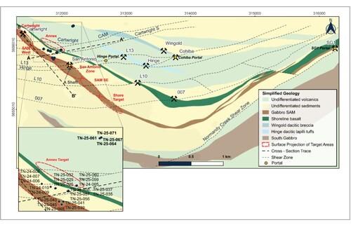
Plan View True North Geology with SAM W and Annex Drill Hole Locations (CNW Group/1911 Gold Corporation)
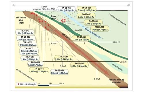
Cross Section Looking NNW SAM W and Annex Targets (CNW Group/1911 Gold Corporation)
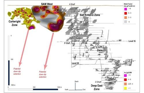
Long Section Looking ENE SAM W Target (CNW Group/1911 Gold Corporation)
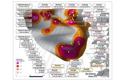
Long Section Looking ENE Expanded View of SAM W with Drill Intercepts (CNW Group/1911 Gold Corporation)
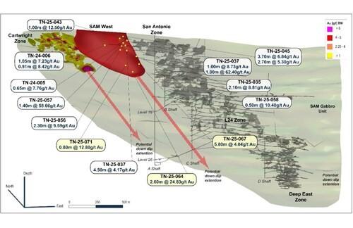
Isometric View Looking NNE SAM W Target with High Grade Gold Intercepts (CNW Group/1911 Gold Corporation)
CPM Group’s 10-Year Copper Outlook are now available. ... READ MORE
Arizona Gold and Silver Inc. (TSX-V: AZS) (OTCQB: AZASF) is ple... READ MORE
Brixton Metals Corporation (TSX-V: BBB) (OTCQX: BBBXF) is pleased... READ MORE
Valkea Resources Corp. (TSX-V: OZ) is pleased to announce the clo... READ MORE
Tiger Gold Corp. (TSX-V: TIGR) (FSE: D150) (OTCQB: TGRGF) is plea... READ MORE


