


Brunswick Exploration Inc. (TSX-V: BRW) (OTCQB: BRWXF) is pleased to report the final set of results obtained as part of the 2025 Winter drill campaign conducted on its Mirage Project. The Mirage Project is located in the Eeyou Istchee–James Bay region of Quebec, approximately 40 kilometers south of the Trans-Taiga Road. This press release primarily focuses on the drilling work carried out in the eastern extension of the MR-6 dyke and the “Stacked Dyke” zone.
Highlights include:
Mr. Killian Charles, President and CEO of BRW, commented: “Brunswick Exploration remains one of the most compelling stories in the mining sector as we leverage the atypical combination of advanced exploration work at Mirage alongside an aggressive global lithium grassroot program which has no comparable peers. As the lithium market regains strength over the coming quarters and years, we are uniquely positioned to benefit from new discoveries and the continued development of Mirage.
“Today’s results serve once more to highlight the exploration potential of Mirage. Even after more than 20,000 meters of drilling over the last 18 months, we have repeatedly and continue to intercept new dykes of appreciable width and grade. As we move toward a maiden resource estimate in late 2025, I am extremely proud of the work the BRW exploration team has achieved across its still growing pipeline of projects.”
Mirage Project Drilling Overview
The Mirage Project comprises 427 claims located roughly 40 kilometers south of the Trans-Taiga Highway in Quebec’s James Bay region and 34 kilometers northeast of Winsome Resources’ Adina Project.
The drilling campaign was primarily aimed at extending the mineralized “Stacked Dyke” zone to the northeast. The highlights presented in this press release are shown in Table 1 and Figures 1 and 2. Collar locations are provided in Table 2.
Figure 1: Zone Location at Mirage Project
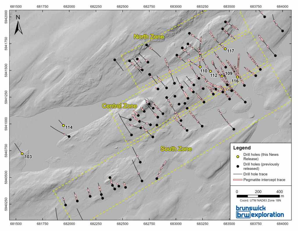
Figure 2: Central Zone of the Mirage Project
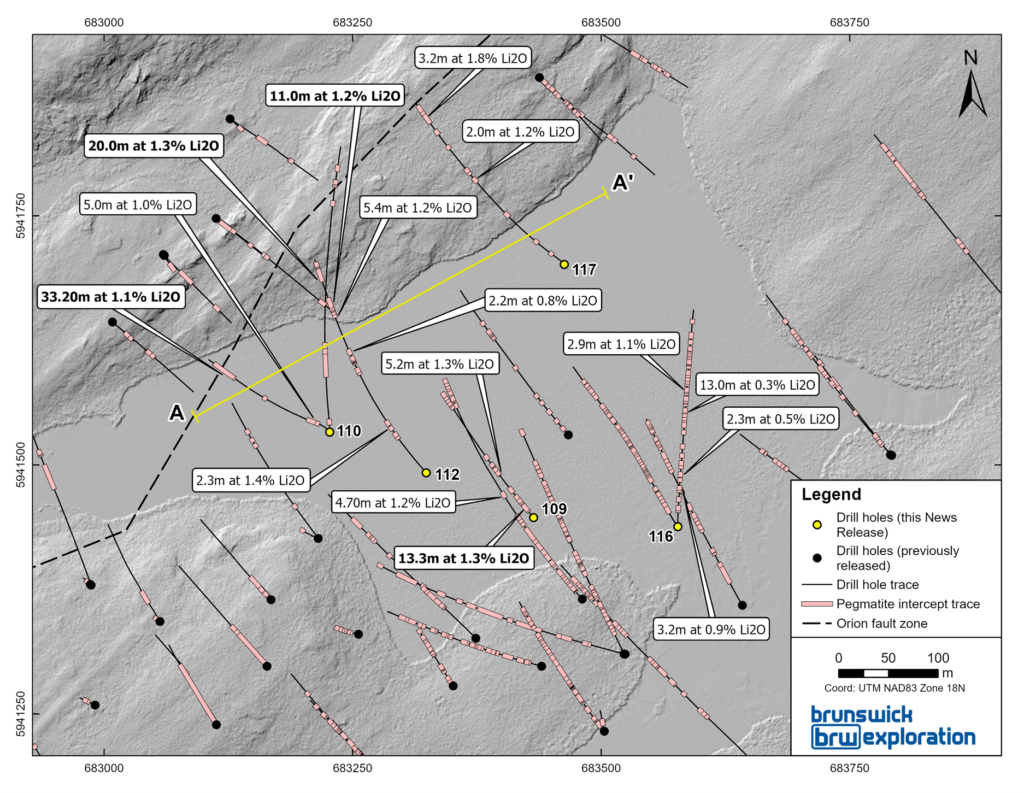
Drill hole MR-25-110 led to the discovery of a new spodumene-bearing pegmatite dyke, grading 1.1% Li₂O over 33.2 meters from 217 to 251 meters (vertical depth of 180 meters), while drill hole MR-25-112 returned 1.3% Li₂O over 20 meters from 367.9 to 387 meters (vertical depth of 290 meters). These two new dykes are interpreted to be sub-parallel, oriented approximately N130/30. Drill hole MR-25-112 also intersected another dyke grading 1.2% Li₂O over 11 meters from 328 to 339 meters (vertical depth of 250 meters), which is believed to be also parallel to the others. These new intersections highlight the stacking of sub-horizontal mineralized dykes in this area. The dykes remain open in all directions.
Figure 3: Section A-A’
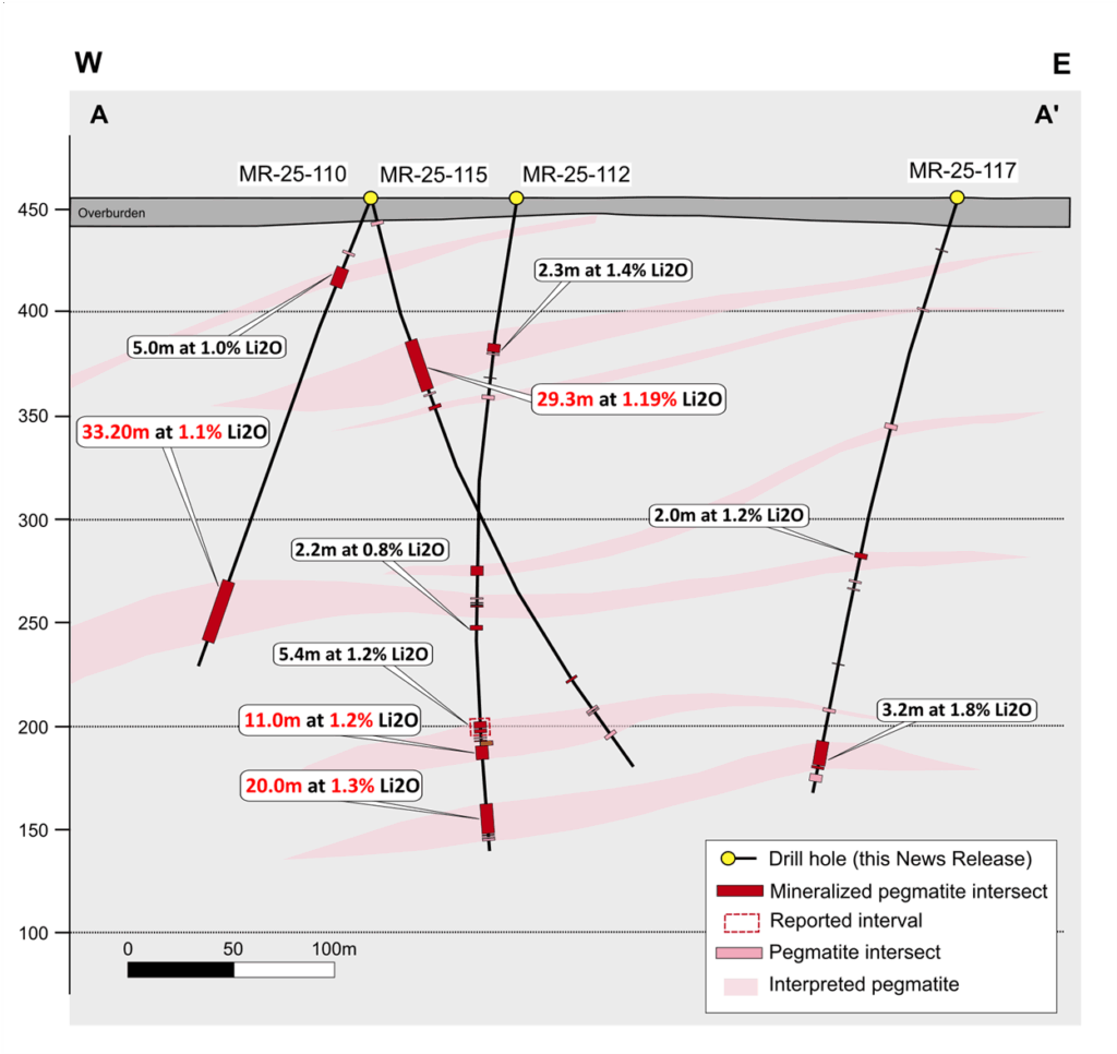
Drill hole MR-25-117 also intersected a 27-meter-wide pegmatite from 329 to 356 meters. This pegmatite is interpreted to be the same one intersected in drill hole MR-25-112 (which returned 1.3% Li₂O over 20 meters from 367.9 to 387 meters). However, due to the proximity of the Lac Orion fault, in MR-25-117, the pegmatite shows significant alteration and the spodumene has been largely replaced by cookeite. As a result, lower values of lithium were reported and only a smaller subinterval returned significant lithium with 1.8% Li₂O over 3.2 meters. Nonetheless, the presence of the dyke over sizeable widths is extremely encouraging and remains an excellent follow-up target for further drilling campaign.
Drill hole MR-25-109 extended the “Stacked Dyke” zone by more than 100 meters to the North, with several spodumene-bearing pegmatite intersections. The widest interval returned 1.3% Li₂O over 13.3 meters, from 21.4 to 34.7 meters. The dykes in this hole are sub-horizontal and demonstrate a change in orientation compared to the central zone, where dykes typically dip 60 to 70 degrees to the southeast.
Drill hole MR-25-116 intersected over forty moderately mineralized pegmatite dykes, generally of limited thickness. While the lithium grades were modest, this hole highlights the strong potential for the mineralized system to continue toward the Northeast. The intersected dykes remain open in all directions.
Drill hole MR-25-113, located approximately 4.5 km northeast of the central zone, was completed as a reconnaissance exploration hole. Unfortunately, no spodumene-bearing pegmatite was intersected in this hole.
Table 1: 2025 Winter Drilling Program Discussed in this Release
| Hole ID | From (m) | To (m) | Length (m) | Li2O (%) | Ta2O5 (ppm) |
| MR-25-109 | 21.4 | 34.7 | 13.3 | 1.3 | 351 |
| MR-25-109 | 64.5 | 69.2 | 4.7 | 1.2 | 266 |
| MR-25-109 | 106.6 | 111.8 | 5.2 | 1.3 | 222 |
| MR-25-110 | 42.6 | 47.6 | 5.0 | 1.0 | 245 |
| MR-25-110 | 217.8 | 251.0 | 33.2 | 1.1 | 128 |
| MR-25-112 | 113.9 | 116.3 | 2.3 | 1.4 | 183 |
| MR-25-112 | 251.5 | 253.7 | 2.2 | 0.8 | 172 |
| MR-25-112 | 316.0 | 321.4 | 5.4 | 1.2 | 193 |
| MR-25-112 | 328.0 | 339.0 | 11.0 | 1.2 | 160 |
| MR-25-112 | 367.9 | 387.8 | 20.0 | 1.3 | 231 |
| MR-25-116 | 52.6 | 55.8 | 3.2 | 0.9 | 172 |
| MR-25-116 | 74.5 | 76.8 | 2.3 | 0.5 | 140 |
| MR-25-116 | 152.0 | 164.9 | 13.0 | 0.3 | 123 |
| MR-25-116 | 200.7 | 203.6 | 2.9 | 1.1 | 141 |
| MR-25-117 | 210.9 | 212.9 | 2.0 | 1.2 | 281 |
| MR-25-117 | 341.5 | 344.6 | 3.2 | 1.8 | 309 |
True thickness is estimated to vary between 80% and 90% across all reported holes in the 2025 Winter campaign.
Table 2: Drill Hole Collars
| Hole ID | Azimut | Dip | Length (m) | UTM NAD83 z18 – East | UTM NAD83 z18 – North |
| MR-25-109 | 300 | -55 | 279 | 683432 | 5941447 |
| MR-25-110 | 300 | -55 | 267 | 683227 | 5941533 |
| MR-25-112 | 300 | -55 | 399 | 683324 | 5941492 |
| MR-25-113 | 300 | -55 | 169.7 | 686828 | 5943668 |
| MR-25-116 | 340 | -45 | 300 | 683577 | 5941438 |
| MR-25-117 | 300 | -50 | 363 | 683463 | 5941701 |
3D model update
Following the completion of the 2025 Winter drill campaign, Brunswick Exploration, in collaboration with PLR Resources (https://www.plr-resources.com/), updated its 3D model in preparation for a first resource estimate planned for late 2025. Figure 3 shows the location of the sections presented in Figures 5 and 6.
Figure 4: Location of Section B-B’ and C-C’
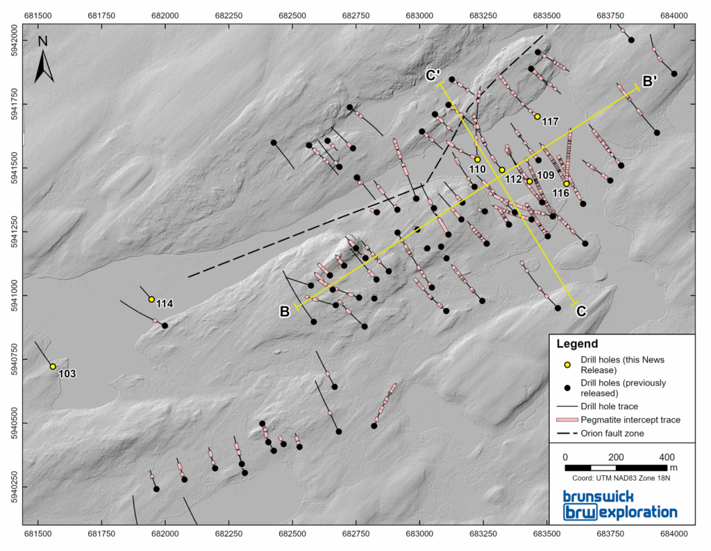
Figure 5: Section B-B’’
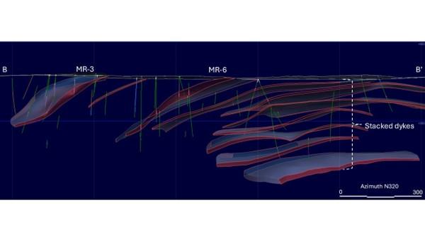
Figure 6: Section C-C’
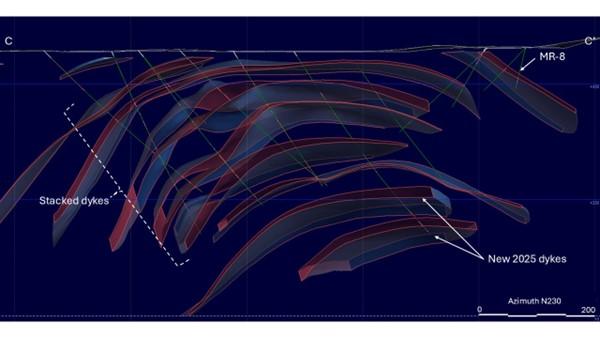
Observations from field work and drilling indicate that the geometry of the pegmatite dykes in the core of the project (covering North, Central and South Zone) is closely linked to a regional antiformal folding pattern. Although the dykes locally appear to be folded, evidence strongly supports that their emplacement was primarily controlled by the hinges of these antiformal folds, rather than the dykes being simply passively deformed post-emplacement.
The emplacement of the pegmatites is interpreted as syn- to post-tectonic, likely occurring towards the final stages of the second deformation event in the region. This timing corresponds with a decrease in regional stress conditions, allowing pegmatitic melts to be focused and emplaced in structurally favorable zones such as fold hinges and lithological contacts.
Hydrothermal alteration observed in specific segments of certain pegmatite dykes, notably at MR-3 and MR-6, indicates post-emplacement metasomatic fluid activity. These fluids are believed to be associated with reactivation along nearby structures, particularly the Orion Lake Fault, which likely acted as a fluid conduit during late-stage tectonism.
Of note, the role of gabbroic units in the area remains to be fully determined; however, their consistent spatial association with pegmatite dykes suggests they may also have influenced pegmatite emplacement. Some pegmatite dykes could be guided by contacts between metagabbro and metavolcanic rocks, potentially acting as rheological boundaries favorable to dyke propagation.
QAQC
All drill core samples were collected under the supervision of BRW employees and contractors. The drill core was transported by helicopter and by truck from the drill platform to the core logging facility in Val-d’Or. Each core was then logged, photographed, tagged, and split by diamond saw before being sampled. All pegmatite intervals were sampled at approximately 1-meter intervals to ensure representativity. Samples were bagged; duplicated on reject, blanks and certified reference materials for lithium were inserted every 20 samples. Samples were bagged and groups of samples were placed in larger bags, sealed with numbered tags, in order to maintain a chain of custody. The sample bags were transported from the BRW contractor facility to the AGAT laboratory in Val-d’Or. All sample preparation and analytical work was performed by AGAT by sodium peroxide fusion with ICP-OES and ICP-MS finish. All results passed the QA/QC screening at the lab and all inserted standard and blanks returned results that were within acceptable limits. All reported drill intersections are calculated based on a lower cutoff grade of 0.3% Li2O, with maximum internal dilution of 5 meters. Host basalts adjacent to the dykes may grade up to 0.3% Li2O but were excluded from the reported intersections.
Qualified Person
The scientific and technical information contained in this press release has been reviewed and approved by Mr. Simon T. Hébert, VP Development. He is a Professional Geologist registered in Quebec and is a Qualified Person as defined by National Instrument 43-101.
About Brunswick Exploration
Brunswick Exploration is a Montreal-based mineral exploration company listed on the TSX-V under symbol BRW. The Company is focused on grassroots exploration for lithium in Canada, a critical metal necessary to global decarbonization and energy transition. The company is rapidly advancing the most extensive grassroots lithium property portfolio in Canada and Greenland.
CPM Group’s 10-Year Copper Outlook are now available. ... READ MORE
Arizona Gold and Silver Inc. (TSX-V: AZS) (OTCQB: AZASF) is ple... READ MORE
Brixton Metals Corporation (TSX-V: BBB) (OTCQX: BBBXF) is pleased... READ MORE
Valkea Resources Corp. (TSX-V: OZ) is pleased to announce the clo... READ MORE
Tiger Gold Corp. (TSX-V: TIGR) (FSE: D150) (OTCQB: TGRGF) is plea... READ MORE


