


![]()
OceanaGold Corporation (TSX: OGC) (OTCQX: OCANF) is pleased to provide results from exploration and resource conversion drilling at the Haile Gold Mine in the United States.
Drill highlights include (core length):
Pisces (initial drilling, located 300 m from Horseshoe)
Horseshoe (definition drilling)
Gerard Bond, President & CEO of OceanaGold, said “Today’s exciting new discovery at Haile continues to demonstrate the exceptional return on investment we receive from exploration. While still early-days at the Pisces discovery, we are excited about its size potential and it remains open in multiple directions. Pisces is close to existing and planned underground infrastructure, which may provide benefits from a mining perspective. Due to the phenomenal exploration success we have seen at Haile recently, including Pisces, Horseshoe and Ledbetter Phase 4, we increased the 2025 exploration budget at Haile by 20% to $10M, the largest exploration budget at Haile since the mine has been in production. This supports our strategy of increasing shareholder value through the drill bit.”
Results can be viewed in 3D using VRIFY at the following link:
https://vrify.com/meetings/recordings/0bcf42cb-b154-4a06-b85c-9f16e267eb8c
|
VRIFY note: Drill results reflect those set forth in OceanaGold’s press release dated February 23, 2025 and do not include all historical drill results except those relevant to the current Pisces exploration target. |
Pisces Discovery
The Pisces discovery is located along the prospective corridor between the Horseshoe and Palomino deposits at approximately 550 metres below surface (Figure 1). Mineralization intercepted to date defines an exploration target1 area of approximately 300 x 250 x 25 metres, where the strike length approximates that of the Horseshoe resource. Mineralization is similar in style to Horseshoe and Palomino, occurring at the metavolcanic/metasediment contact, and hosted by silicified and sulphidized laminated siltstone with zones of local brecciation.
A total of 3,437 metres and five holes have been drilled during the current program, testing the thickness and continuity of mineralization in the vicinity of historical drill holes. Significant intercepts were returned including 44.2 m @ 10.9 g/t Au (DDH1267), 9.4 m @ 44.1 g/t Au (DDH1269), and 42.7 m @ 6.1 g/t Au (DDH1257) (see Figure 2 for DDH1257 and DDH1267 and Table 1). This drilling follows up on the historic results in this area which include 14.4 m @ 4.7 g/t Au (RCT0205), 24.4 m @ 3.1 g/t Au (RCT0165) and 7.6 m @ 7.4 g/t Au (RCT0209) (see Table 2 for historical drill hole results).
Mineralization at Pisces remains open in all directions; to the northeast towards Horseshoe and to the southwest towards Palomino, as well as up and down dip. Drilling has been accelerated with an increased budget to better define the continuity of geology and grade, and ascertain the potential size of this new opportunity, as early as possible.
| ________________________________ | |
| 1. | The exploration target is based on the assessment of limited drill data collected by the Company at Haile. The exploration target is conceptual in nature and insufficient exploration has been undertaken in the area that the exploration target relates to estimate a Mineral Resource. It is uncertain if further exploration will result in the estimation of a Mineral Resource. |
Horseshoe
Eighteen additional resource definition holes for 5,587 metres have been completed since the cut-off date for the 2024 year-end resource estimate for the Horseshoe underground (see news release dated February 19, 2025). These holes targeted southwest extensions to Horseshoe and focused on defining the continuity and extent of three zones: the middle zone with 12 holes, the lower zone with 5 holes, and the upper zone with 1 hole (Figure 3). The results received were in line with expectations and support potential additional growth of the Horseshoe underground resource.
Extensions of the middle zone returned 12.9 m @ 50.1 g/t Au (UGD0073) and 11.1 m @ 4.4 g/t Au (UGD0061). Additional significant results within the middle zone resource include 31.9 m @ 11.7 g/t Au (UGD0075), 21.7 m @ 7.3 g/t Au (UGD0069), 19.4 m @ 6.7 g/t Au (UGD0077), and 19.2 m @ 6.5 g/t Au (UGD0063) (see Table 1).
Extensions of the lower zone include 4.8 m @ 5.4 g/t Au (UGD0071) and 3.1 m @ 6.4 g/t Au (UGD0068).
An additional 10,500 metres of resource definition and conversion drilling in 2025 has commenced at Horseshoe.
Table 1: Recent Haile drill intersections.
| Hole ID | From | To | Interval | Au | Target | Activity |
| (m) | (m) | (m) | (g/t) | |||
| DDH1266 | NSR | Pisces | Initial Drilling | |||
| DDH1267 | 591.0 | 635.1 | 44.2 | 10.9 | Pisces | Initial Drilling |
| DDH1269 | 686.1 | 695.5 | 9.4 | 44.1 | Pisces | Initial Drilling |
| Including | 686.1 | 687.6 | 1.5 | 228.0 | Pisces | Initial Drilling |
| Including | 687.6 | 690.1 | 2.5 | 15.1 | Pisces | Initial Drilling |
| DDH1257 | 560.2 | 602.9 | 42.7 | 6.1 | Pisces | Initial Drilling |
| Including | 587.4 | 590.7 | 3.3 | 30.9 | Pisces | Initial Drilling |
| DDH1247 | NSR | Pisces | Initial Drilling | |||
| UGD0058 | 288.8 | 298.2 | 9.3 | 3.1 | Horseshoe | Definition |
| UGD0059 | NSR | Horseshoe | Definition | |||
| UGD0060 | 258.5 | 265.8 | 7.3 | 4.1 | Horseshoe | Definition |
| UGD0061 | 257.5 | 268.6 | 11.1 | 4.4 | Horseshoe | Definition |
| UGD0063 | 272.8 | 292.0 | 19.2 | 6.5 | Horseshoe | Definition |
| UGD0064 | 270.7 | 281.3 | 10.7 | 1.8 | Horseshoe | Definition |
| UGD0065 | 255.4 | 278.0 | 22.6 | 5.3 | Horseshoe | Definition |
| UGD0066 | NSR | Horseshoe | Definition | |||
| UGD0067 | 252.6 | 260.7 | 8.1 | 4.6 | Horseshoe | Definition |
| UGD0068 | 259.1 | 263.2 | 3.1 | 6.4 | Horseshoe | Definition |
| UGD0069 | 256.6 | 278.3 | 21.7 | 7.3 | Horseshoe | Definition |
| Including | 266.4 | 272.2 | 5.8 | 16.0 | Horseshoe | Definition |
| UGD0071 | 261.7 | 266.6 | 4.8 | 5.4 | Horseshoe | Definition |
| UGD0072 | 272.2 | 279.6 | 7.4 | 16.1 | Horseshoe | Definition |
| UGD0073 | 264.2 | 277.1 | 12.9 | 50.1 | Horseshoe | Definition |
| Including | 266.2 | 267.5 | 1.2 | 149.0 | Horseshoe | Definition |
| UGD0074 | NSR | Horseshoe | Definition | |||
| UGD0075 | 228.6 | 260.5 | 31.9 | 11.7 | Horseshoe | Definition |
| Including | 238.8 | 242.3 | 3.6 | 54.9 | Horseshoe | Definition |
| UGD0076 | 338.3 | 345.5 | 7.2 | 11.9 | Horseshoe | Definition |
| UGD0077 | 242.8 | 262.1 | 19.4 | 6.7 | Horseshoe | Definition |
| And | 272.4 | 288.0 | 15.6 | 6.6 | Horseshoe | Definition |
|
Notes: |
||||||
| • Intervals are core length, not true width. | ||||||
| • “Initial Drilling” intercept is associated with early-stage exploration drilling, while “Definition” drilling are intercepts outside the current resource model shell directed at converting mineralization to an Inferred resource category. NSR = No Significant Result. |
Table 2: Historical Haile drill intersections relevant to the current Pisces exploration target.
| Hole ID | From | To | Interval | Au | Target | Activity |
| (m) | (m) | (m) | (g/t) | |||
| DDH0397 | NSR | Pisces | Initial Drilling | |||
| DDH0596^ | NSR | Pisces | Initial Drilling | |||
| DDH0598^ | NSR | Pisces | Initial Drilling | |||
| DDH0474 | NSR | Pisces | Initial Drilling | |||
| DDH0467 | NSR | Pisces | Initial Drilling | |||
| DDH0622A^ | NSR | Pisces | Initial Drilling | |||
| RCT0083** | 385.6 | 393.2 | 7.6 | 11.7 | Pisces | Initial Drilling |
| RCT0145* | NSR | Pisces | Initial Drilling | |||
| RCT0147 | 545.1 | 548.6 | 3.5 | 3.4 | Pisces | Initial Drilling |
| RCT0165* | 684.3 | 708.7 | 24.4 | 3.1 | Pisces | Initial Drilling |
| RCT0166 | NSR | Pisces | Initial Drilling | |||
| RCT0198 | NSR | Pisces | Initial Drilling | |||
| RCT0205 | 720.2 | 735.8 | 14.4 | 4.7 | Pisces | Initial Drilling |
| RCT0208 | NSR | Pisces | Initial Drilling | |||
| RCT0209 | 598.9 | 606.6 | 7.6 | 7.4 | Pisces | Initial Drilling |
| Notes: | ||||||
| • Intervals are core length, not true width. | ||||||
| • “Initial Drilling” intercept is associated with early-stage exploration drilling. NSR = No Significant Result. | ||||||
| • All data, apart from DDH0596, DDH0598 and DDH0622A represent historical drilling conducted by Romarco Minerals prior to OceanaGold’s ownership of Haile. |
||||||
| • “^” represents OceanaGold drilled holes. | ||||||
| • “*” represents drill hole results reported by Romarco Minerals in its press release dated April11, 2012. | ||||||
| • “**” represents drill hole results reported by Romarco Minerals in its press release dated January 20, 2012. | ||||||
| All historical drill data collected by Romarco Minerals are considered historical in nature and based on prior data and reports prepared by Romarco Minerals. A qualified person from the Company has not undertaken independent investigation of the sampling nor has it independently analyzed the results of the historical drilling to verify the results. OceanaGold is not treating the historical data as current. There can be no assurance that any of the historical drill data is representative. |
For further information relating to drill hole data please refer to the Company’s website at https://investors.oceanagold.com/additional-drillhole-data.
About OceanaGold
OceanaGold is a growing intermediate gold and copper producer committed to safely and responsibly maximizing the generation of Free Cash Flow from our operations and delivering strong returns for our shareholders. We have a portfolio of four operating mines: the Haile Gold Mine in the United States of America; Didipio Mine in the Philippines; and the Macraes and Waihi operations in New Zealand.
Qualified Person Statement
The scientific and technical information contained in this press release, other than historic drill data, has been reviewed and approved by Craig Feebrey, a Member of the Australasian Institute of Mining and Metallurgy and a qualified person under National Instrument 43-101 – Standards of Disclosure for Mineral Projects of the Canadian Securities Administrators (“NI 43-101”). Mr. Feebrey is the Executive Vice President and Chief Exploration Officer of OceanaGold.
QA/QC at Haile Gold Mine
From July 2017 to 2024 almost all Haile exploration core samples have been prepared at the ALS lab in Tucson, Arizona, and analyzed at the ALS lab in Reno, Nevada, each of which is independent from OceanaGold. Select resource conversion core samples were also prepared and analyzed at the SGS lab in Kershaw, South Carolina in 2023 which is also independent from OceanaGold, with confirmation pulp duplicates sent to the ALS lab in Reno, Nevada. Samples are pulverized from a 250g (ALS) or 450g (SGS) sample to 85% passing 75 mesh. Approximately 225g of pulp sample is used for fire assay. Assays are based on a 30g fire assay aliquot for gold with Atomic Absorption finish. If the gold value from Atomic Absorption is >10g/t, an additional 30g of pulp sample is fire assayed for gold using a gravimetric finish. Some holes are composited and analyzed for carbon, sulphur and multi-elements using LECO and ICP-OES methods. Both ALS and SGS labs used for OceanaGold samples are ISO 17025 certified.
Blanks and standards are each inserted every 20th sample. Precision and accuracy of certified reference materials (“CRMs”) compared to expected values have been consistently within 5% RSD and often within 3%. Barren marble and sand are inserted as blanks every 20th sample. CRMs from RockLabs are inserted every 20th sample (5%). CRMs from RockLabs and OREAS are inserted every 20th sample (5%). All blanks and CRMs are handled by the OceanaGold Geology Team and are stored in the locked OceanaGold office.
All drill hole samples are handled and transported from the drill rigs to the secured Haile Exploration warehouse by OceanaGold personnel. Access to the property is controlled by locked doors and cameras monitored by OceanaGold security. The main gate requires an electronic employee badge to enter. Samples are packaged at the Haile Exploration warehouse by OceanaGold geologists and geotechnicians. Samples are trucked in sealed plastic barrels by certified couriers with submittal forms that are verified during sample pick-up and delivery to ALS. No sample shipments have been recorded as missing or tampered with.
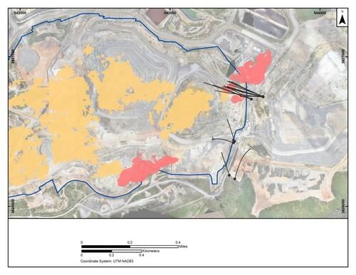
Figure 1: Plan view of the location of the Pisces exploration target (CNW Group/OceanaGold Corporation)
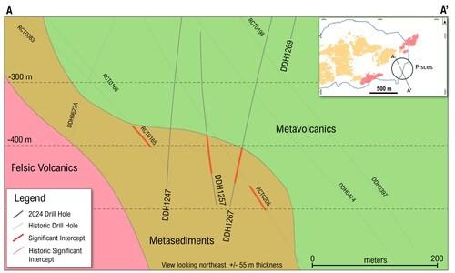
Figure 2: Long section A-A’ showing Pisces exploration target with drill holes (including historic drill holes) annotated (CNW Group/OceanaGold Corporation)
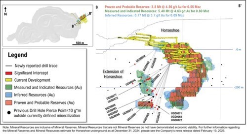
Figure 3: Schematic long section (looking north-west) showing Horseshoe mineralization and recent drill holes annotated (CNW Group/OceanaGold Corporation)
Titan Mining Corporation (NYSE-A:TII) (TSX:TI), an existing zinc concentrate producer in upstate New... READ MORE
Searchlight Resources Inc. (TSX-V: SCLT) (OTC Pink: SCLTF) is pleased to announce that it has close... READ MORE
Nuvau Minerals Inc. (TSX-V: NMC) reports encouraging results from its winter drilling campaign at th... READ MORE
Pacific Ridge Exploration Ltd. (TSX-V: PEX) (OTCQB: PEXZF) (FSE: PQW) is pleased to announce that it... READ MORE
Ximen Mining Corp. (TSX-V: XIM) (FSE: 1XM) (OTC Pink: XXMMF) is pleased to provide the following upd... READ MORE


