WALKER RIVER ANNOUNCES SIGNIFICANT GOLD INTERCEPTS INCLUDING 3.88 G/T OVER 77.72 METERS AT THE LAPON GOLD PROJECT

Walker River Resources Corp. (TSX-V: WRR) is pleased to announce additional assay results from the 2024 reverse circulation drill program at the Lapon Canyon portion of the Lapon Gold Project, in Mineral County, Nevada, 60 km SE of Yerington, NV.
Highlights
| From | To | Width* | Gold | ||
| Drill Hole | (m) | (m) | (m) | (g/t) | |
| LC-24-117 | 74.68 | 152.4 | 77.72 | 3.88 | |
| including | 77.72 | 94.49 | 16.77 | 12.09 | |
| and | 100.58 | 112.78 | 12.2 | 4.08 | |
| LC-24-118 | 68.58 | 128.02 | 59.44 | 1.96 | |
| including | 68.58 | 74.68 | 6.10 | 8.17 | |
| LC-24-110 | 41.15 | 74.68 | 33.53 | 2.70 | |
| including | 45.72 | 57.91 | 12.19 | 5.99 | |
| LC-24-113 | 21.34 | 48.77 | 27.43 | 2.58 | |
| including | 25.91 | 32.00 | 6.09 | 4.13 | |
| and | 39.62 | 44.20 | 4.58 | 4.79 | |
| 68.58 | 76.20 | 7.62 | 1.90 | ||
| including | 70.10 | 73.15 | 3.05 | 4.08 | |
| LC-24-114 | 16.76 | 172.21 | 155.45 | 0.61 | |
| including | 44.20 | 83.82 | 39.62 | 0.90 | |
| and | 103.63 | 117.35 | 13.72 | 2.32 | |
| and | 129.54 | 132.59 | 3.05 | 2.19 | |
| LC-24-119 | 33.53 | 38.10 | 4.57 | 1.06 | |
| 108.20 | 152.40 | 44.2 | 0.87 | ||
| including | 124.97 | 126.49 | 1.52 | 4.13 |
Table 1. Highlighted holes released today. * Denotes the above drill results are presented with lengths representing sampled lengths. True width is estimated to be between 80 and 95 percent of sampled widths.
- Drill hole LC-24-117 returned 3.88 g/t Au over 77.72 meters starting at a depth of 74.68 meters including an intercept of 12.09 g/t Au over 16.77 meters, demonstrating the robust nature of the gold mineralization of the Hotspot zone.
- Drill holes LC-24-114 (0.61 g/t Au over 155.45 metres), LC-24-118 (1.96 g/t Au over 59.44 metres), and LC-24-113 (2.58 g/t Au over 27.34 meters) were also drilled in the Hotspot, clearly demonstrating continuity of the gold mineralization. LC-24-114 was shutdown in mineralization (0.14 g/t Au over 36.58 metres) at a vertical depth of approximately 140 metres and extends Hotspot to the south another 40 metres.
- Drill hole LC-24-110 intercepted 2.70 g/t Au over 33.53 meters and LC-24-113 (2.58 g/t over 27.34 meters). These intercepts extend Hotspot Zone west, toward the Central Zone by approximately 50 metres.
- Notably, LC-24-117, which was drilled to a depth of 152.4 meters remained in gold mineralization at the bottom of the hole, with the interval from 128.02 meters to the bottom returning 0.96 g/t Au over 24.38 metres. This intercept is at approximately 120 m vertical depth, highlighting the zone’s potential at depth.
- LC-24-119 also drilled to depth of 152 meters and remained in mineralization at the bottom of the hole, with the interval from 124.97 meters to the bottom returning 1.23 g/t Au over 27.43 metres. This intercept extends mineralization at Hotspot approximately 50 m to the southeast from all previous holes drilled.
- The 2024 drill programs at Lapon Canyon were exploration and definition focused. Drill holes were planned with the intent to define the extent and geometry of the mineralized system and test for new mineralized zones along strike and at depth.
- Drilling at Lapon Canyon is carried out in different directions (azimuths) from the same drill pad, for systematic drilling on section, drill pads are placed at every 30 to 60 meters, with up to five holes per pad.
- Previous and current drilling continue to define a sub to horizontal geometry of the gold system. High grade shoots may have developed within the broader mineralized domains.
| Drill Hole | From | To | Width* | Gold | |
| (m) | (m) | (m) | (g/t) | ||
| LC-24-107 | 12.19 | 53.34 | 41.15 | 0.55 | |
| Including | 36.58 | 47.24 | 10.66 | 1.24 | |
| LC-24-108 | 0.00 | 60.96 | 60.96 | 0.44 | |
| LC-24-109 | 0.00 | 57.91 | 57.91 | 0.31 | |
| Including | 38.10 | 50.29 | 12.19 | 0.76 | |
| LC-24-110 | 41.15 | 74.68 | 33.53 | 2.70 | |
| Including | 45.72 | 57.91 | 12.19 | 5.99 | |
| LC-24-111 | 76.20 | 102.11 | 25.91 | 0.14 | |
| LC-24-112 | 24.38 | 35.05 | 10.67 | 0.24 | |
| 91.44 | 118.87 | 27.43 | 0.18 | ||
| LC-24-113 | 21.34 | 48.77 | 27.43 | 2.58 | |
| including | 25.91 | 32.00 | 6.09 | 4.13 | |
| and | 39.62 | 44.20 | 4.58 | 4.79 | |
| 68.58 | 76.20 | 7.62 | 1.90 | ||
| including | 70.10 | 73.15 | 3.05 | 4.08 | |
| LC-24-114 | 16.76 | 172.21 | 155.45 | 0.61 | |
| Including | 44.20 | 83.82 | 39.62 | 0.90 | |
| and | 103.63 | 117.35 | 13.72 | 2.32 | |
| and | 129.54 | 132.59 | 3.05 | 2.19 | |
| 192.02 | 228.60 | 36.58 | 0.14 | ||
| LC-24-115 | 105.16 | 115.82 | 10.66 | 0.37 | |
| LC-24-116 | 36.58 | 68.58 | 32.00 | 0.30 | |
| including | 65.53 | 68.58 | 3.05 | 2.09 | |
| LC-24-117 | 15.24 | 65.53 | 50.29 | 0.23 | |
| 74.68 | 152.4 | 77.72 | 3.88 | ||
| Including | 77.72 | 94.49 | 16.77 | 12.09 | |
| Including | 100.58 | 112.78 | 12.2 | 4.08 | |
| LC-24-118 | 0 | 21.34 | 21.34 | 0.35 | |
| 35.05 | 59.44 | 24.39 | 0.27 | ||
| 68.58 | 128.02 | 59.44 | 1.96 | ||
| Including | 68.58 | 74.68 | 6.10 | 8.17 | |
| LC-24-119 | 0 | 10.67 | 10.67 | 0.1 | |
| 33.53 | 38.10 | 4.57 | 1.06 | ||
| 108.20 | 152.40 | 44.2 | 0.87 | ||
| Including | 124.97 | 126.49 | 1.52 | 4.13 |
Table 2. All drill holes and intervals released today. * Denotes the above drill results are presented with lengths representing sampled lengths. True width is estimated to be between 80 and 95 percent of sampled widths

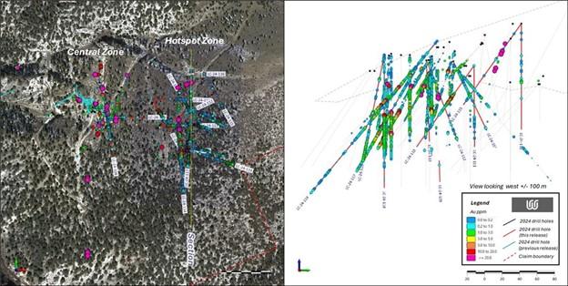
Figure 1: Plan and section view of the Hotspot zone, Central zone, with assay results from historical drilling (grey traces) and 2024 drilling (red traces).
Michel David, Walker River’s President & CEO states: “We are extremely encouraged by these current and past drill results which continue to confirm the potential of the project. We look forward to additional results from Lapon Canyon and very excited with our ongoing interpretation of the gold mineralization at Lapon Canyon.”
On-going work at Lapon Canyon consists of data compilation, interpretation and resource modelling. Further results will be released as they become available. Field work will restart as soon as conditions allow.
The results from the 2024 drill programs and subsequent data compilation will enable the completion of an initial NI 43-101 compliant mineral resource on the Project.
Sampling Methodology, Chain of Custody, Quality Control and Quality Assurance
All sampling was conducted under the supervision of the Company’s project geologists and the chain of custody from the drill to the sample preparation facility was continuously monitored. A blank or certified reference material was inserted approximately every tenth sample. The Lapon Canyon samples were delivered to American Assays Laboratories’ certified laboratory facilities in Sparks, NV. The samples were crushed, pulverized and the sample pulps digested and analyzed for gold using fire assay fusion and a 50 g gravimetric finish. Certain intensely altered samples used a 1 kg pulp screened to 100 microns. Duplicate assay on screen undersize. Assay of entire oversize fraction.
Samples are taken and bagged directly at the drill rig at every 1.5-meter interval, standard in the exploration industry. A small sample is also taken at the drill rig and put into a chip tray for examination purposes and to determine those sample bags that should be sent to the lab for assay purposes. Often this work is carried out using a microscope for the examination of the rock chips. The full sample bag from the interval chosen for assay purposes is then sent directly from the drill site to the lab, located in Sparks, NV.
The scientific and technical information contained in this news release has been reviewed, verified and approved by Dave Nuttall P.Geo, President of Serac Exploration, who is an independent Qualified Person as defined under NI 43-101 Standards of Disclosure for Mineral Projects.
About the Lapon Gold Project
The Lapon Gold Project consists of 147 claims (2940 acres) situated in the Wassuk Range, within the Walker Lane shear zone, a 100 km wide structural corridor extending in a southeast direction from Reno, Nevada. The Project is easily accessible by secondary state roads from the main highway (25 kilometres), and is located approximately 60 kilometres southeast of Yerington, Nevada. A state power grid transmission line passes within three kilometres of the Project.
The Lapon Gold Project includes Lapon Canyon, the Pikes Peak claims located 4 kilometres to the north, and the Rattlesnake and Range Front claims 3 kilometres to the west and over 600 meters lower than the present drilling at Lapon Canyon.
The Rattlesnake, Range Front, and Pikers Peak claims cover over 8 km of possible extensions of the range front zones to the west, north, and south of Lapon Canyon, adding several additional drill target areas to the project. Rattlesnake and Pikes Peak contain numerous historical mining and milling areas that consist of adits at different levels, shafts and underground workings, and a network of existing roads providing access throughout. Little or no exploration work has been carried out on these claims prior to Walker’s arrival. It is notable that the Rattlesnake area and adits are on strike with the Lapon Canyon discoveries located 3 km on strike and 600 meters above.Lapon Canyon hosts historical high grade gold mining with approximately 2000 feet of undergoing workings in three adits. Historical underground work returned numerous assay values in the one ounce per ton range, with a sample at the end of the A adit returning 20.6 ounces per ton Au. (NI 43-101, Montgomery and Barr, 2004).
MORE or "UNCATEGORIZED"
Aldebaran Announces Closing of $40 Million Bought Deal Offering
Aldebaran Resources Inc. (TSX-V: ALDE) (OTCQX: ADBRF) is please... READ MORE
Erdene Announces Closing of $25 Million Bought Deal Private Placement
Erdene Resource Development Corp. (TSX:ERD) (MSE:ERDN) (OTCQX: ER... READ MORE
NOVAGOLD Announces Closing of Upsized Bought Deal for Gross Proceeds of US$310 Million
NOVAGOLD RESOURCES INC. (NYSE: NG) (TSX: NG) is pleased to report... READ MORE
Guanajuato Silver Sees Significant Growth in Resources at Valenciana
~ Inferred Mineral Resources Increased by 630% to 20.3M AgEq Ounc... READ MORE
Copper Quest Increases and Closes Unit Offering for Total Gross Proceeds of $2,099,890
Copper Quest Exploration Inc. (CSE: CQX) (OTCQB: IMIMF) (FRA: 3MX... READ MORE


